Gesamtpreis (1 Artikel Artikel):
Versandziel:

anglia regnum (19 Ergebnisse)
Direkt zu den wichtigsten Suchergebnissen
Suchfilter
Produktart
- Alle Product Types
- Bücher (6)
- Magazine & Zeitschriften (Keine weiteren Ergebnisse entsprechen dieser Verfeinerung)
- Comics (Keine weiteren Ergebnisse entsprechen dieser Verfeinerung)
- Noten (Keine weiteren Ergebnisse entsprechen dieser Verfeinerung)
- Kunst, Grafik & Poster (Keine weiteren Ergebnisse entsprechen dieser Verfeinerung)
- Fotografien (Keine weiteren Ergebnisse entsprechen dieser Verfeinerung)
- Karten (13)
- Manuskripte & Papierantiquitäten (Keine weiteren Ergebnisse entsprechen dieser Verfeinerung)
Zustand Mehr dazu
- Neu (Keine weiteren Ergebnisse entsprechen dieser Verfeinerung)
- Wie Neu, Sehr Gut oder Gut Bis Sehr Gut (1)
- Gut oder Befriedigend (6)
- Ausreichend oder Schlecht (Keine weiteren Ergebnisse entsprechen dieser Verfeinerung)
- Wie beschrieben (12)
Einband
- alle Einbände
- Hardcover (Keine weiteren Ergebnisse entsprechen dieser Verfeinerung)
- Softcover (1)
Weitere Eigenschaften
- Erstausgabe (Keine weiteren Ergebnisse entsprechen dieser Verfeinerung)
- Signiert (Keine weiteren Ergebnisse entsprechen dieser Verfeinerung)
- Schutzumschlag (Keine weiteren Ergebnisse entsprechen dieser Verfeinerung)
- Angebotsfoto (16)
Sprache (3)
Preis
- Beliebiger Preis
- Weniger als EUR 20 (Keine weiteren Ergebnisse entsprechen dieser Verfeinerung)
- EUR 20 bis EUR 45 (Keine weiteren Ergebnisse entsprechen dieser Verfeinerung)
- Mehr als EUR 45
Gratisversand
- Kostenloser Versand nach USA (Keine weiteren Ergebnisse entsprechen dieser Verfeinerung)
Land des Verkäufers
Verkäuferbewertung
-
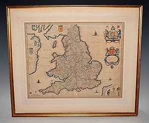
Anglia Regnum - Original Copper Engraved Map - 1650
Sprache: Englisch
Verlag: Joan Blaeu, Amsterdam, 1650
Anbieter: Hornseys, Ripon, Vereinigtes Königreich
Verbandsmitglied: PBFA
Verkäuferbewertung 5 von 5 Sternen

EUR 298,15
EUR 28,95 Versand
Versand von Vereinigtes Königreich nach USAAnzahl: 1 verfügbar
In den WarenkorbNo Binding. Zustand: Very Good. Date: c.1650. Latin text to the reverse. Sheet Size: 56.5cm x 43.4cm. Original or early hand-colouring. Original central fold lines. Minor creasing. Short closed tear to the base of the central fold line which has been repaired to the reverse with archive tape. Very minor age-toning but generally very bright and clean with good margins. A strong impression. Overall in very good condition. Scarce thus.
-

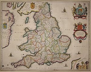
Anglia Regnum
Verlag: Amsterdam, 1634
Anbieter: Clive A. Burden Ltd., Chalfont St. Giles, BUCKS, Vereinigtes Königreich
Verkäuferbewertung 5 von 5 Sternen
Karte
EUR 310,08
EUR 25,65 Versand
Versand von Vereinigtes Königreich nach USAAnzahl: 1 verfügbar
In den WarenkorbNo binding. 385 x 495 mm., early outline colour, with Spanish text, with tear to the upper margin repaired, in good condition. The Blaeu firm's first topographical atlas appeared in 1630 in one volume and was gradually expanded. By 1640 it was in three volumes and contained just 4 British Isles maps. His chief rival, the Hondius-Jansson atlas contained 18 maps. Both joined a race to make their fourth volumes a complete atlas of the British Isles. Blaeu was first, publishing his magnificent work in 1645. Of the general maps contained Blaeu was also the first to produce one of England and Wales first appearing in 1634. The map is derived from that of John Speed although hear lacking the figures along the sides as befitted the new style being set by the Dutch mapmakers. It is however beautifully decorated with the coats of arms of Great Britain and Ireland along with an ornate scale and title cartouche. There is known to exist a proof state of this map, so technically this is a second state, with Spanish text as issued in 1659. Koeman (1967-70) Bl. 5 no. 107 p. 89; Shirley (1991) no. 440; Van der Krogt, P. (Atlantes) 5100:2.
-
AN ORIGINAL ENGRAVED MAP OF Anglia regnum. Copper engraved map of the Kingdom of England
Verlag: Atlas Novus Ca 1642, 1642
Anbieter: PROCTOR / THE ANTIQUE MAP & BOOKSHOP, DORCHESTER, Vereinigtes Königreich
Verbandsmitglied: PBFA
Verkäuferbewertung 5 von 5 Sternen
Karte
EUR 459,15
EUR 23,16 Versand
Versand von Vereinigtes Königreich nach USAAnzahl: 1 verfügbar
In den WarenkorbLg.map (engr.surface 20.5 x 16 inches). In ivory mount. An attractive and decorative map in very good condition. Mount a little tanned. Nicely Original hand-coloured. Jan Jansson Jr (1588-1664), or Johannes Janssonius, was the son of a bookseller and publisher who had worked with Jodocus Hondius Sr. From about 1633 onwards, his imprint appears on the title-pages of the Mercator-Hondius "Atlas", in conjunction with his brother-in-law, Henry, as they re-issued their "Atlas" in competition with the Blaeus.
-

Anglia Regnum.
Verlag: Amsterdam, 1630, Latin text edition. 350 x 460mm (13ľ x 18 inches)., 1630
Anbieter: Tooley, Adams & Co., Wallingford, OXON, Vereinigtes Königreich
Verkäuferbewertung 4 von 5 Sternen

EUR 453,19
EUR 43,01 Versand
Versand von Vereinigtes Königreich nach USAAnzahl: 1 verfügbar
In den WarenkorbUncoloured; minor marginal nicks and toning to the edges of the paper, short repaired tear to lower centrefold in the margin, small rust spot in Ireland, otherwise a very good example. Mercator's map of England and Wales is on a larger scale than his map of the British Isles, because of this he is able to include more place names. Although based on Saxton, there are some curious spellings of places, suggesting perhaps that the engraver was using a foreign source. SHIRLEY: No.181. KOEMAN: Me 29A.
-
Anglia Regnum, Mercator-Hondius, anno 1630, old colours
Verlag: Mercator Gerhard, 1512-1594, 1630
Anbieter: Hammelburger Antiquariat, Hammelburg, Deutschland
Verkäuferbewertung 4 von 5 Sternen
Karte
Kein Einband. Zustand: Gut. Anglia Regnum, Mercator-Hondius, anno 1630, old colours Coppermap, edited by Mercator-Hondius, approx. anno 1630, Original colours, size of the leaf: 47 x 55 cm., french text on verso, wide margins.
-

Anglia regnum
Verlag: c.1623, Amsterdam, 1623
Anbieter: Alexandre Antique Prints, Maps & Books, Toronto, ON, Kanada
Verkäuferbewertung 5 von 5 Sternen
Karte
Zustand: Very Good. A highly detailed and beautiful map of England. Latin text on verso. Gerardus Mercator (1512?1594) was a Flemish geographer, cosmographer and cartographer. He is most renowned for creating the 1569 world map based on a new projection which represented sailing courses of constant bearing (rhumb lines) as straight lines. Mercator was a notable maker of globes and scientific instruments. He also had interests in theology, philosophy, history, mathematics, and geomagnetism. He was also an accomplished engraver and calligrapher., Size : 470x354 (mm), 18.50x13.94 (Inches), Original Hand Coloring.
-
EARLY LARGE RARE MAP OF ENGLAND 1595 " Anglia Regnum." From the French text edition of Mercator?s Atlas III
Verlag: Duisberg 1595, 1595
Anbieter: PROCTOR / THE ANTIQUE MAP & BOOKSHOP, DORCHESTER, Vereinigtes Königreich
Verbandsmitglied: PBFA
Verkäuferbewertung 5 von 5 Sternen
EUR 498,51
EUR 23,16 Versand
Versand von Vereinigtes Königreich nach USAAnzahl: 1 verfügbar
In den WarenkorbLarge coloured map held in wooden frame with glass front. Engraved Size 47cm x 35cm Frame Size 66cm x 56cm Very good. Large Margins, with a few faint marks. Old frame has small chip on hand hand side. FRENCH text to verso. ORIGINAL slightly GARISH HAND COLOURING This hand colored first state Mercator map of Great Britain of 1595 is a highly detailed rendering of England as it was at the end of the 16th century. Eastern Ireland and the west coast of Holland, Belgium and France are also included. Cities, ports, churches, estates and forts are included in the map, and it is embellished by a lovely frigate sailing off the coast between Holland and Suffolk.
-

Anglia Regnum.
Verlag: Amsterdam, 1636-. French text edition. 390 x 500mm (15Ľ x 19ľ inches)., 1636
Anbieter: Tooley, Adams & Co., Wallingford, OXON, Vereinigtes Königreich
Verkäuferbewertung 4 von 5 Sternen
EUR 500,89
EUR 43,01 Versand
Versand von Vereinigtes Königreich nach USAAnzahl: 1 verfügbar
In den WarenkorbFinely coloured; very slight age-toning as is often the case with maps by Jansson, minor nicks to the edges of the paper, short centrefold split to lower margin, repaired, otherwise a fine example. One of the most attractive early Dutch maps of England and Wales available.
-

Magnae Britanniae pars meridionalis in qua Regnum Anglia .
Verlag: Artist: Homann Johann Babtiste ( - 1724 ) Nuremberg ca : 1710, 1664
Anbieter: Antique Sommer& Sapunaru KG, München, Deutschland
Verkäuferbewertung 3 von 5 Sternen

Technic: Copper print, colorit: original colored, condition: Very good, size (in cm): 55 x 48 cm, Map shows the whole of England with magnificent cartouches.
-

Anglia Regnum si quod Aliud in Toto Oceano Ditissimum et Florentissimum
Verlag: Paris, 1605
Anbieter: Clive A. Burden Ltd., Chalfont St. Giles, BUCKS, Vereinigtes Königreich
Verkäuferbewertung 5 von 5 Sternen
Karte
EUR 2.206,32
EUR 25,65 Versand
Versand von Vereinigtes Königreich nach USAAnzahl: 1 verfügbar
In den WarenkorbNo binding. Zustand: Good. 385 x 480 mm., with double folds as usual, small tear at double fold professionally repaired, otherwise in good condition. Jean Le Clerc (1560-c.1621) was an engraver, bookseller, and publisher who spent a number of years in Tours before moving to Paris sometime around 1594. This very rare map is derived from the Abraham Ortelius - Christopher Saxton map of 1603, itself ultimately from Saxton's map of 1579. This example is in the second state with his name present. The first is extremely rare. It replicates Saxton's map of England of 1579 in a beautifully engraved style. A naval battle is taking place off the Cornish coast. Le Clerc is most noted for his separately published set of continental maps c.1602. In 1619 Le Clerc re-issued Maurice Bouguereau's 'Theatre Francois' of 1594 as the 'Theatre Geographique du Royaume de France' and included many new plates. A good example of a beautifully engraved map often found in poor condition. Provenance: Clive A. Burden Ltd. 2009; private English collection. Kelly (2007); Loeb-Larocque (1989); Pastoureau (1984) Le Clerc; Shirley (1991) 271.
-

Anglia Regnum.
Verlag: Amsterdam, 1633, French text edition. 350 x 460mm (13ľ x 18 inches)., 1633
Anbieter: Tooley, Adams & Co., Wallingford, OXON, Vereinigtes Königreich
Verkäuferbewertung 4 von 5 Sternen
EUR 667,86
EUR 43,01 Versand
Versand von Vereinigtes Königreich nach USAAnzahl: 1 verfügbar
In den WarenkorbFine original colour; minor marginal defects, otherwise a very good example. Mercator's map of England and Wales is on a larger scale than his map of the British Isles, because of this he is able to include more place names. Although based on Saxton, there are some curious spellings of places, suggesting perhaps that the engraver was using a foreign source. SHIRLEY: No.181. KOEMAN: Me 36A.
-
Anglia, Regnum si quod aliud in toto Oceano ditissimum et florentissimum
Verlag: c.1603, Antwerp, Belgium, 1603
Anbieter: Alexandre Antique Prints, Maps & Books, Toronto, ON, Kanada
Verkäuferbewertung 5 von 5 Sternen
Karte
Zustand: Very Good, margins extended. Important map of United Kingdom by Ortelius based on an earlier map by Christopher Saxton in 1579., Size : 384x483 (mm), 15.12x19.02 (Inches), Hand Colored.
-

Anglia Regnum.
Verlag: Anversa, Jean Baptiste Vrients, 1603
Anbieter: Libreria Ex Libris ALAI-ILAB/LILA member, Roma, RM, Italien
Verkäuferbewertung 5 von 5 Sternen
Karte
Incisione originale su rame (cm. 48,8x39 piů margini) tratta dal 'Theatrum Orbis Terrarum'. Splendida coloritura antica all'acquarello. Abili restauri lungo la piegatura centrale e lievi tracce di ossidazione ma buon esemplare. Provenienza: Biblioteca del Castello di Cirey. Van den Broecke, 20.
-
Anglia Regnum
Verlag: c. 1633, Amsterdam, 1633
Anbieter: Alexandre Antique Prints, Maps & Books, Toronto, ON, Kanada
Verkäuferbewertung 5 von 5 Sternen
Karte
Early Latin example of Mercator\\\\\\\\\\\\\\\'s map of Great Britain first published in \"Atlas Sive Cosmographia.\\\" Includes a decorative cartouche and a ship at sale. French text on Verso. , Size : 349x467 (mm), 13.75x18.40 (Inches), Hand Colored Map is strengthened by acid free tissue paper for long term preservation. Otherwise, Generally Good.
-

Anglia Regnum in Omnes Suos Ducatus, Comitatus, et Provincias Divisum.
Verlag: Amsterdam, 1680
Anbieter: Alexandre Antique Prints, Maps & Books, Toronto, ON, Kanada
Verkäuferbewertung 5 von 5 Sternen
Karte
Size : 575x485 (mm), 22.625x19.125 (Inches), Original Hand Coloring, 0 Very Good, laid on contemporary thick paper. Some browning due to the colour transfer of the image on the opposite page while in atlas.
-

Magnae Britanniae Pars Meridionalis in qua Regnum Anglia tam in Septum Antiqua Anglo-Saxonum Regna (.)
Verlag: J.B. Homann, 1730
Anbieter: Antiquariaat Dat Narrenschip, Middelburg, Niederlande
Verkäuferbewertung 5 von 5 Sternen
Karte
No Binding. Zustand: Good. Antique map of England and Wales. Top right cartouche with title and publisher's imprint. At the bottom a decorative vignette with an image of a government council with a British monarch. Scale sticks bottom left. Backside blank. Copper engraving with partial old colour, published around 1730 in Nuremberg by Johann Baptist Homann. Bottom right, near London, a professionally restored tear. Some small tears have been repaired in the margins. Dimensions (image): 58 x 49 cm.
-

Anglia regnum
Verlag: Jodocus Hondius, 1619
Anbieter: Antiquariaat Dat Narrenschip, Middelburg, Niederlande
Verkäuferbewertung 5 von 5 Sternen
Karte
No Binding. Zustand: Fine. Antique map of England. Title cartouche with scale stick top right. Latin text on the back. Hand-coloured copper engraving, made by Gerard Mercator in 1585. Published in Amsterdam in 1619 by Jodocus Hondius in "Atlas Sive Cosmographicae Meditationes De Fabrica Mundi Et Fabricati Figura. (.)." A tear in the center fold below was repaired on verso. Dimensions (image): 36 x 47 cm.
-

Kupferstich- Karte, b. Janssonius & Hondius, "Anglia Regnum".
Sprache: Deutsch
Anbieter: Antiquariat Clemens Paulusch GmbH, Berlin, Deutschland
Verkäuferbewertung 5 von 5 Sternen
Karte
mit altem Grenzkolorit, 1638, 39 x 50 Koeman's Atlantes Neerlandici, 5100:1B Shirley, British Isles ( 1477 - 1650 ), Nr. 482. - Am rechten Rand Titelkartusche mit Wappen, darüber großes Wappen.
-
Anglia regnum
Sprache: Deutsch
Erscheinungsdatum: 1642
Anbieter: Kunstantiquariat Andreas Senger, Hamburg, Deutschland
Verkäuferbewertung 5 von 5 Sternen
Karte
Kein Einband. Zustand: Gut. Es handelt sich hierbei um eine originale, kolorierte Kupferstich-Landkarte des Königreichs England von Johann Janssonius (1588 - 1664) aus dem Jahr 1642. *** Titel: Anglia regnum *** Gebiet bzw. Ort: England, Großbritannien *** Kartograph: Johann Janssonius (1588 - 1664) *** Jahr: 1642 *** Größe des Plattenbereichs: 39 x 50 cm *** Technik: Kupferstich *** Zustand (Perfekt/ Sehr gut/ Gut/ Ordentlich/ Mäßig/ Schlecht): In gutem Erhaltungszustand *** Bemerkungen: - - - - International buyers welcome. If you have any questions, please don't hesitate to ask. - - - ----- Auf Wunsch stellen wir Ihnen gerne ein kostenfreies Echtheitszertifikat aus ------ If you wish, we will gladly provide a certificate of authenticity free of charge ---.