Gesamtpreis (1 Artikel Artikel):
Versandziel:

africae tabula nova (22 Ergebnisse)
Direkt zu den wichtigsten Suchergebnissen
Suchfilter
Produktart
- Alle Product Types
- Bücher (8)
- Magazine & Zeitschriften (Keine weiteren Ergebnisse entsprechen dieser Verfeinerung)
- Comics (Keine weiteren Ergebnisse entsprechen dieser Verfeinerung)
- Noten (Keine weiteren Ergebnisse entsprechen dieser Verfeinerung)
- Kunst, Grafik & Poster (3)
- Fotografien (Keine weiteren Ergebnisse entsprechen dieser Verfeinerung)
- Karten (11)
- Manuskripte & Papierantiquitäten (Keine weiteren Ergebnisse entsprechen dieser Verfeinerung)
Zustand Mehr dazu
- Neu (Keine weiteren Ergebnisse entsprechen dieser Verfeinerung)
- Wie Neu, Sehr Gut oder Gut Bis Sehr Gut (Keine weiteren Ergebnisse entsprechen dieser Verfeinerung)
- Gut oder Befriedigend (5)
- Ausreichend oder Schlecht (Keine weiteren Ergebnisse entsprechen dieser Verfeinerung)
- Wie beschrieben (17)
Einband
- alle Einbände
- Hardcover (Keine weiteren Ergebnisse entsprechen dieser Verfeinerung)
- Softcover (Keine weiteren Ergebnisse entsprechen dieser Verfeinerung)
Weitere Eigenschaften
- Erstausgabe (1)
- Signiert (Keine weiteren Ergebnisse entsprechen dieser Verfeinerung)
- Schutzumschlag (Keine weiteren Ergebnisse entsprechen dieser Verfeinerung)
- Angebotsfoto (20)
Sprache (2)
Preis
- Beliebiger Preis
- Weniger als EUR 20 (Keine weiteren Ergebnisse entsprechen dieser Verfeinerung)
- EUR 20 bis EUR 45 (Keine weiteren Ergebnisse entsprechen dieser Verfeinerung)
- Mehr als EUR 45
Gratisversand
Land des Verkäufers
Verkäuferbewertung
-

Nova Africae Tabula Auctore Jodoco Hondio
Verlag: Artist: Hondius Hendrik ( - 1650 ) Amsterdam; issued in: Amsterdam; ca: 1619, 1597
Anbieter: Antique Sommer& Sapunaru KG, München, Deutschland
Verkäuferbewertung 4 von 5 Sternen

EUR 1.010,00
EUR 45,00 Versand
Versand von Deutschland nach USAAnzahl: 1 verfügbar
In den WarenkorbTechnic: Copper print, colorit: original colored, condition: Some restorations due to original color, mounted., size (in cm): 37 x 50, Map shows total Africa with its countries and borders, decorative offshore ships, sea monsters and animals.
-

Africae Tabula Nova.
Verlag: Antwerp, 1570-, Latin text edition. 375 x 505mm (14ľ x 20 inches)., 1573
Anbieter: Tooley, Adams & Co., Wallingford, OXON, Vereinigtes Königreich
Verkäuferbewertung 4 von 5 Sternen
EUR 1.963,98
EUR 42,93 Versand
Versand von Vereinigtes Königreich nach USAAnzahl: 1 verfügbar
In den WarenkorbPossibly original colour; light soiling to margins, overall a very good example. This beautiful map although derivative is nevertheless one of the cornerstones of any African map collection. (Tooley). Geographically a close copy of Gastaldi's map of 1564, Ortelius adding only one new name Cayneca and making his Cape more pointed. Zanzibar is now on the West Coast and the Nile is based on Ptolemy. It is difficult to date this map precisely, van den Broecke indicates that the number 4 on the verso and the Latin text appears first in 1570, there are a further six editions with Latin text until 1603, when the date under the title is removed. This example has the date 1570. TOOLEY: Africa p.88, illus. NORWICH: 10; VAN DEN BROECKE: 8.
-

Africae Tabula Nova.
Verlag: Antwerp, 1570-1603, Latin text edition. 375 x 505mm (14ľ x 20 inches)., 1602
Anbieter: Tooley, Adams & Co., Wallingford, OXON, Vereinigtes Königreich
Verkäuferbewertung 4 von 5 Sternen
EUR 1.666,41
EUR 42,93 Versand
Versand von Vereinigtes Königreich nach USAAnzahl: 1 verfügbar
In den WarenkorbUncoloured; small hole in the lower margin, expertly repaired and hardly noticeable, otherwise a superb example. This beautiful map although derivative is nevertheless one of the cornerstones of any African map collection. (Tooley). Geographically a close copy of Gastaldi's map of 1564, Ortelius adding only one new name Cayneca and making his Cape more pointed. Zanzibar is now on the West Coast and the Nile is based on Ptolemy. It is difficult to date this map precisely, van den Broecke indicates that the number 4 on the verso and the Latin text appears first in 1570, there are a further six editions with Latin text until 1603, when the date under the title is removed. This example still has the date 1570, but the copperplate has cracked in the title, indicating 1602. TOOLEY: Africa p.88, illus. NORWICH: 10; VAN DEN BROECKE: 8.
-

Africae Tabula Nova.
Verlag: Antwerp, 1570-, Latin text edition. 375 x 505mm (14ľ x 20 inches)., 1573
Anbieter: Tooley, Adams & Co., Wallingford, OXON, Vereinigtes Königreich
Verkäuferbewertung 4 von 5 Sternen
EUR 2.023,49
EUR 42,93 Versand
Versand von Vereinigtes Königreich nach USAAnzahl: 1 verfügbar
In den WarenkorbOriginal colour; light soiling to margins, very short split to the lower margin at centrefold, otherwise a superb example. This beautiful map although derivative is nevertheless one of the cornerstones of any African map collection. (Tooley). Geographically a close copy of Gastaldi's map of 1564, Ortelius adding only one new name Cayneca and making his Cape more pointed. Zanzibar is now on the West Coast and the Nile is based on Ptolemy. It is difficult to date this map precisely, van den Broecke indicates that the number 4 on the verso and the Latin text appears first in 1570, there are a further six editions with Latin text until 1603, when the date under the title is removed. This example has the date 1570. TOOLEY: Africa p.88, illus. NORWICH: 10; VAN DEN BROECKE: 8.
-

Africae Tabula Nova.
Verlag: Antwerp, Belgium, 1570
Anbieter: Alexandre Antique Prints, Maps & Books, Toronto, ON, Kanada
Verkäuferbewertung 5 von 5 Sternen

Karte
Zustand: Very Good, age toning. Map of Africa Continent by Abraham Ortelius, published in Theatrum Orbis Terrarum, Latin Text on verso., Size : 367x495 (mm), 14.45x19.49 (Inches), Original Hand Coloring, 0.
-
Africae Tabula Nova.
Verlag: Antwerp, Belgium, 1570
Anbieter: Alexandre Antique Prints, Maps & Books, Toronto, ON, Kanada
Verkäuferbewertung 5 von 5 Sternen
Karte
Zustand: Very Good, age toning. Map of Africa Continent by Abraham Ortelius, published in Theatrum Orbis Terrarum,Latin Text on verso., Size : 378x507 (mm), 14.88x19.96 (Inches), Original Hand Coloring, 0.
-
![Bild des Verkäufers für AFRICAE Nova Tabula [Africa] zum Verkauf von Frame](https://pictures.abebooks.com/inventory/md/md31239910359.jpg)
Zustand: ACEPTABLE. [Un] Mapa, correspondiente a la primera estampación en blanco y negrode la edición de 1636 de los mapas de Mercator-Hondius editados para el Novus Atlas de Janssonius. Edición con el texto en latín al dorso. Johannes Janssonius (también conocido como Johann, o Jan Jansson, o Janszoon), nació en Arnhem en 1588 y falleció en Amsterdam en1664. Hijo de Jan Janssen, fue un renombrado geógrafo y editor del siglo XVII, en el contexto en que los holandeses dominaban la publicación de mapas en Europa. Jan conoció el oficio por primera vez a través de su padre, quien también era librero y editor. En 1612, se casó con Elisabeth Hondius, hija de Jodocus Hondius y hermana de Henricus. Tras su matrimonio, se instalaron en Amsterdam, donde él ejercería como librero y editor de material cartográfico. Curiosamente, se instaló junto a la librería Blaeu, yasí estalló la encarnizada competencia entre Jan Janssonius yWillem Jansz Blaeu (1571-1638). En la década de 1630, Janssonius trabajó con su cuńado, Henricus Hondius (1597-1651), hijo de Jodocus. Su obra más exitosa fue la reedición del atlas "Mercator-Hondius". Jodocus había adquirido las planchas del atlas de Mercator, publicado por primera vez en 1595, y agregó 36 mapas adicionales. Los primeros mapas de Jonssonius datan de 1616. Tras la muerte de Jodocus Hondius, el mismo ańo que Janssonius se casó con su hija(1612), Henricus se hizo cargo de la publicación y en 1633 Janssonius se unió a la empresa y comenzaron a publicar atlas juntos, hasta 1640, ańo en que Henricus dejó el negocio enteramente a Janssonius. Su gran atlas pasaría a llamarse ahora Atlas Novus, y llegó a constar de 6 volúmenes;y más tarde, dada la rivalidad con Joan Blaeu, hijo y sucesor de Willem, volvería a ampliarloy a editarlo con el título deAtlas Major y en once volúmenes. Las planchas de cobre de los atlas de Janssonius se vendieron posteriormente a Schenk y Valck. ___________ First State and edition of this map printed in Black and whitefor the Mercator-Hondius Novus Atlas in 1636 with latin text. Formato (cm): 51 aprox.x53.
-
No binding. Zustand: Very good. First. Antwerp: [N.p.], 1570 or later. Double-page map of AFRICA (FIRST STATE) from the Latin edition of Abraham ORTELIUS' "THEATRUM ORBIS TERRARUM" (17 Ľ x 21 ˝ inches; 14 ˝ x 19 ľ inches plate size) with original hand color and full margins. Condition: very good; some creasing in top half along the margins and extending into the image; repair in top right quadrant. LAVISHLY colored map of Africa (including a naval battle scene) based on the cartographical information of Gastaldi's 8-sheet map from 1564 and to a lesser extent the Mercator world map from 1569. Norwich (1983) finds that the "Theatrum Orbis Terrarum" added one name, Carneca, to Gastaldi's Africa, and made the Cape more pointed. Zanzibar is transferred from the east to the west coast. The Nile is based on the Ptolemaic concept. The present map counts as a prototypical representation of Africa in 16th century cartography.
-

Africae tabula nova
Verlag: Anversa, Jean Baptiste Vrients, 1603
Anbieter: Libreria Ex Libris ALAI-ILAB/LILA member, Roma, RM, Italien
Verkäuferbewertung 4 von 5 Sternen
Karte
Incisione originale su rame (cm. 50,5x37,5 piů ampi margini) tratta dal 'Theatrum Orbis Terrarum'. Splendida coloritura antica all'acquarello. Margini bianchi laterali con mancanze, altrimenti ottimo esemplare. Provenienza: Biblioteca del Castello di Cirey. Van den Broecke, 8.
-

Africae nova Tabula. Auct. Hen. Hondio. 1631.
Verlag: Hondius, 1631
Anbieter: Angelika C. J. Friebe Ltd. - MapWoman, Dorking, Vereinigtes Königreich
Verkäuferbewertung 4 von 5 Sternen
Karte
EUR 1.309,32
EUR 23,11 Versand
Versand von Vereinigtes Königreich nach USAAnzahl: 1 verfügbar
In den WarenkorbNo Binding. Zustand: Very Good. Hondius Amsterdam 1633 copper engraved map ; overall 48 x 58 cm; plate 38 x 49 cm. Fold as issued; one vertical soft fold; paper evenly toned; small worm holes; some marginal dusting; o/w vg cond. A very decorative map of the African continent by Jodocus Hondius for Mercator's 'Atlas sive Geographicae'. The map is decorated with an elaborate title cartouche and various sailing ships and sea monsters. French text on verso. Pagination 621/624. Hondius intended this map to be part of the first edition Mercator's atlas; unfortunately, the project didn't get finished until 1606, 12 years after Mercator's death, with many edition in Latin, French, Dutch and English. After Hondius' death in 1612, the atlas continued to be published under his name but by his widow until 1619, after which it was republished by his second son, Henricus. [ref: 3382].
-

Regnorum Siciliae et Sardiniae nec non Melitae sen Maltae, Insula cum adjectis Italiae et Africae Litoribus Nova Tabula. Auctore. Ioh. Bapt: Homanno Geogra Norimbergae. Homann, Johann Sardinia Copper Engraving, Hand Colored Grosser Atlas, Nuremberg 1720
Verlag: Homann 1720-30, Nürnberg, 1720
Anbieter: Antiquariat Reinhold Berg eK Inh. R.Berg, Regensburg, Deutschland
Verkäuferbewertung 5 von 5 Sternen
Karte
Other. Original antique hand-colored copper engraving, from the Homann atlas, published in Nuremberg, 1720. Depicting Sardinia, this map is a fine example of 1720s European cartography. Image: 488 by 578mm (19 by 22 inches). An attractive and historically significant 18th-century map for the discerning collector. Johann Baptist Homann (16641724) was the most important German cartographer and publisher of the early 18th century. Born in Bavaria, he founded his cartographic publishing house in Nuremberg in 1702, which rapidly became the leading German map publisher. In 1715, Emperor Charles VI appointed him Imperial Geographer (Kayserlicher Geographus), the highest cartographic honor in the Holy Roman Empire. Homann's maps are known for their superb copper engraving, rich hand coloring, and elaborate allegorical cartouches featuring figures, coats of arms, and historical vignettes. After his death in 1724, the firm continued as 'Homann Erben' (Homann's Heirs) and published maps well into the 19th century. Homann maps are held at the Germanisches Nationalmuseum in Nuremberg and major international institutions.A very decorative map of Sicily and Sardinia. With many engraved place-names, rivers. In the upper middle is a allegoric figurative cartouche. Inside the map are a lot of Isles pictured. On the map are same ships to see. At the left lower side is a small picture which shows the region from the famous Vulcan Aetna.A fine example from Grosser Atlas, Nuremberg, sought after by collectors of antique maps of Italy, antique maps of Sardinia, and antique hand-colored copper engravings for sale. In very good condition. Light age-toning to the sheet, as expected for a 18th-century map. In excellent condition. 488 by 578mm (19 by 22 inches). 488 by 578mm (19 by 22 inches).
-
Africae Tabula Nova
Verlag: Ortelius, Abraham, Antwerp, 1570
Anbieter: Antikvariat Krenek, Prag, Tschechien
Verbandsmitglied: ILAB
Verkäuferbewertung 5 von 5 Sternen
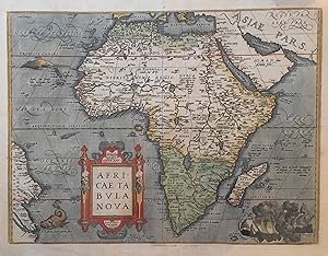
Africa. "Africae Tabula Nova". Orig. copperplate engraving. A. Ortelius, Antwerp, 1570. With ornamental title-cartouche, 3 sea-monsters and a depiction of a naval battle. 37,5:50 cm (14 3/4 x 19 3/4 inch.). Norwich 10; V. d. Broecke 8.1; Koeman III, map 8600:31, Lat. ed. - First state with the date. - This fine early image of the African continent is based on the Gastaldi wall map of 1564. Published in a Latin edition of Ortelius's ground-breaking atlas Theatrum Orbis Terrarum, it is embellished with a ferocious sea battle southeast of Madagascar and several sea monsters in the Atlantic. The drawing of the far eastern coast of Brazil, shown as well below the Equator, differs significantly from the World and America maps.
-
Tabula Nova Partis Africae
Verlag: Vienna, 1541
Anbieter: Antipodean Books, Maps & Prints, ABAA, Garrison, NY, USA
Verbandsmitglied: ABAA ANZAAB ESA ILAB
Verkäuferbewertung 4 von 5 Sternen
Zustand: Very good condition. The second map to show just southern Africa; it is based on the Waldseemuller modern map of southern Africa, and derived from Ptolemy. Decoratively illustrated with African kings, serpents, an elephant and a Christian soldier riding a sea monster towards Madagascar. Three large rivers arise from a mountain range, labeled 'Fontes Nili' (source of the Nile), other mountain ranges, and coastal towns named in Latin or Portuguese. With the figure of the King of Portugal riding a sea monster towards Madagascar. Based on the slightly larger map from 1513 published in "Ptolemy's Geographia". The atlas was reprinted in 1520, 1522, 1525, 1535 and 1541. This wood block was cut in 1525 for the publisher J.Grünninger. This being the variant of 1541, now without the banner title, but title in letter type and blank verso. From the last edition of Ptolemy's "Geography", with maps by Laurens Fries and the text edited by Michael Servetus. Servetus was accused of heresy and burnt at the stake. Calvin ordered that copies of the book should be burnt with him, although this copy seems to have eluded the flames. Wood block map with early hand color. Blank on the verso, with the number 39 at the lower right corner. Image size: 16 7/8 x 13". Paper size: 21 1/4 x 15". Strengthened on the verso, very faint browning at middle of center fold, otherwise very good. Betz, p. 55-56. Tooley, "Map Collectors' Circle, No. 30 Printed Maps of the Continent of Africa Part II", p. 61-62. Karrow, "Mapmakers of the Sixteenth Century".
-

World Map and 4 continents - set of 5 engraved handcolored maps. - "Mappa Totius Mundi vel Planiglobium Terrestris" - "Nova Tabula Americae" - "Nova Tabula Europae" - "Nova Tabula Asiae" - "Nova Tabula Africae"
Sprache: Deutsch
Verlag: Augsburg, Kilian, 1759
Anbieter: Antiquariat Steffen Völkel GmbH, Seubersdorf, Deutschland
Verkäuferbewertung 5 von 5 Sternen
Kunst / Grafik / Poster
EUR 1.200,00
EUR 30,00 Versand
Versand von Deutschland nach USAAnzahl: 1 verfügbar
In den Warenkorbeach map-size c. 27 x 34,5 cm -- each sheet c. 300 x 370mm -- the map of Africa with marginal tear into image on bottom, not closed and no loss. -- light age toning -- a very rare and decorative set. -- On the world map and the America map California is shown as an island. // Wir, das Antiquariat Steffen Völkel, kaufen und verkaufen alte Bücher, Handschriften, Zeichnungen, Autographen, Grafiken und Fotografien. Wir sind stets am Ankauf von kompletten Bibliotheken, Sammlungen und Nachlässen interessiert. Sprache: Deutsch Gewicht in Gramm: 550.
-
Africae nova tabula Auct. J. Hondio New map of Africa designed by J Hondius
Erscheinungsdatum: 1673
Anbieter: Rare Collections, Brighton East, VIC, Australien
Verbandsmitglied: ABA
Verkäuferbewertung 5 von 5 Sternen
Jan Evertsz Cloppenburg (Publisher) Pieter vd Keere engraved the map [1630] 1673 Introductio in universam geographiam Amsterdam; Johannes Janssonius van Wesberge, 1673 [1630] This small map (25cm x 18.5cm) was engraved by Pieter van den Keere (AKA Petrus Kaerius) and is in the 1st state. It seems to be based on the 1617 map by Willem Blaeu's 1617 and the Jodocus Hondius II maps of 1619 & 1623; The map was used in a number of publications, originally in Atlas Minor (Mercator / Hondius) - with the number 11 at the top right. The features of no page number, no signature and no print above the map are consistent with its publication in the 1673 Atlas Minor. "The Cloppenburch (i.e. Jan Evertz Clobbenburg) version of the Mercator-Hondius Atlas Minor (i.e. this map) was only published in 1630, 1632, and 1636. Cloppenburch was either forced out of business or Johannes Janssonius bought his copperplates, as the plates later appeared in a 1673 edition of Atlas Minor by Johannes Janssonius van Waesberge, the son-in-law of Janssonius. A second edition of this atlas appeared in 1676 in Dutch and Latin. This map also appeared in 1676 in an edition of Phillip Clüver's Introductionis in Universam Geographicam." (Betz's Mapping of Africa # 65) This outline coloured map is in very good condition. There is age-toning (paper oxidation) outside the plate line (especially at the top and on the right) caused by prior mounting non non-archival boards., some chipping to the top edges, Acid free tape strips on the top back from previous mounting. Small 2mm hole of the west coast of Southern Africa between the coast and the illustrated boat 250 by 185mm (9ľ by 7Ľ inches).
-
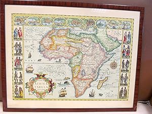
Nova Africae Tabula Auctore Jodoco Hondio. Excusum in edubus Auctoris Amsterdammi 1617. ( Nachdruck )
Anbieter: Antiquariat Friederichsen e. K., Hamburg, Deutschland
Verbandsmitglied: BOEV
Verkäuferbewertung 5 von 5 Sternen
Kunst / Grafik / Poster
Bildmaß der Darstellung ca. 41 x 61 cm ( Höhe x Breite ), Rahmenmaß ca. 54 x 70 cm ( ungeöffnet ). Der offensichtliche Nachdruck mit zahlreichen kleinen die Karte umgebenden Vignetten mit Figuren und Ortsansichten, auf der Karte eine schöne Titelkartusche, eine Windrose, einige Schiffe und Meeresgetier. Das schöne Blatt ist im weißen Außenrand gebräunt, und gering fleckig sonst von guter Erhaltung. Der Rahmen ist stärker bestoßen. ( Bitte beachten: Hier ist wegen Bruchgefahr und Übergröße leider kein Versand möglich - hier bitte nur Selbstabholung nach Absprache bzw. selbst organisierter Abtransport ). ( Lagerort KG ) ( Weitere Bilder auf Anfrage ) / Artikel 22247 /// Image size approx. 41 x 61 cm (height x width), frame size approx. 54 x 70 cm (unopened). This is an apparent reprint with numerous small vignettes surrounding the map, depicting figures and townscapes. The map itself features a beautiful title cartouche, a compass rose, and several ships and marine animals. The attractive sheet is browned along the white outer edge and slightly stained, otherwise in good condition. The frame shows more significant wear. (Please note: Due to the risk of breakage and its size, shipping is unfortunately not possible collection in person by prior arrangement or self-organized transport is preferred.) (Location: KG) (Further images available upon request) / Item 22247 /// Dimensions de l'image: env. 41 x 61 cm (hauteur x largeur); dimensions du cadre: env. 54 x 70 cm (non ouvert). Il s'agit vraisemblablement d'une réimpression ornée de nombreuses vignettes représentant des personnages et des paysages urbains. La carte elle-męme présente un élégant cartouche de titre, une rose des vents, ainsi que plusieurs navires et animaux marins. La belle feuille est brunie sur le bord blanc extérieur et légčrement tachée, mais reste en bon état. Le cadre est plus usé. (Attention: en raison du risque de casse et de ses dimensions, l'expédition est malheureusement impossible. Le retrait sur place (sur rendez-vous) ou le transport par vos soins sont préférables.) (Lieu: KG) (Photos supplémentaires disponibles sur demande) / Article 22247.
-

Africae nova Tabula.
Erscheinungsdatum: 1650
Anbieter: Geographicus Rare Antique Maps, Brooklyn, NY, USA
Verbandsmitglied: ABAA ESA ILAB
Verkäuferbewertung 4 von 5 Sternen
Karte
Very good. Upper margin reinforced and recornered, else excellent. Size 14 x 18.5 Inches. This is Peter Mariette's 1650 map of Africa, published in his Theatre Géographique de France . The present example is a rare French edition that does not appear in OCLC and has appeared only twice on the market since 2008. A Long-Lived and Influential Mapping This map's geography originally appeared in the 1619 Africae nova Tabula of Jodocus Hondius Jr. as part of his set of four continent maps and remained a staple of the Hondius/Janssonius atlases. It was widely copied: Bertius, Tavernier, Boisseau, and Berey all produced works based on this map, as did Mariette. The present map of Africa - though anonymous - is attributed to Peter Mariette, who included it in his 1650 Theatre Géographique de France . Although published in Paris, the map's geography and decorative elements are Dutch, leading some to believe it to have been engraved by Cornelis Danckerts. A Closer Look The map's cartography follows Hondius' original both in terms of detail and execution. The coastline, in particular, is rich in toponomy, and the overall shape of the continent is accurate. Points within the continent, nonetheless, reveal the European ignorance of Africa's interior that would remain largely unchanged until well into the 19th century. The Nile, for example, is illustrated with its sources in the lakes of Zaire and Zaflan, an assumption inherited from no less venerable an authority than the 2nd-century Alexandrian geographer Claudius Ptolemy. The equally fictitious Lake Sachaf, derived from Laurent Fries' 1522 geography, appears in southern Africa, feeding the Zambere River, which flows to the Rio de Spirito Santo. The Cuama River is shown north of the Rio de Spirito Santo, but unlike earlier maps (including the 1608 Blaeu wall map), the Cuama is given its own source rather than sharing Lake Sachaf. The Niger River is shown running, essentially, in the wrong direction, emptying into the Senegal River after having flowed from a supposed Lake Niger (a misunderstanding of the Niger Inland Delta?) in the general vicinity of what is now the Central African Republic. (The detailed mapping of the Niger River would not be complete until the 1890s.) The map is embellished with lions, zebras, elephants, ostriches, and camels. There is even, south of the Niger River, a dragon. Flying fish skim the waters west of Guinea, and two ships sail the Oceanus Aethiopicus in the lower left quadrant of the map. Publication History and Census Betz attributes the work to Pierre Mariette, who included it in his c. 1650 Theatre Géographique de France . This map's engraver is unknown, but Betz proposes Cornelis Danckerts, who collaborated with Mariette on the 1647 Totius Africae Nova et Exacta . The map is rare. There are no examples cataloged in OCLC, and it has only appeared on the market twice since 2008. References: Betz, R., The Mapping of Africa #80.
-

Regnorum Siciliae et Sardiniae nec non Melitae, seu Maltae Insuale cum adjectis Italiae, et Africae Litoribus Nova Tabula.
Erscheinungsdatum: 1710
Anbieter: Geographicus Rare Antique Maps, Brooklyn, NY, USA
Verbandsmitglied: ABAA ESA ILAB
Verkäuferbewertung 3 von 5 Sternen

Karte
Very good. Minor soiling to bottom corners. Contemporaneous backing on paper. Minor partial centerfold split, fully stabilized on verso. Size 20.5 x 23.25 Inches. A beautiful example of Johann Baptist Homann's 1710 map of Sicily and Sardinia, Italy. The map illustrates the islands as they were vigorously contended for by the Spanish Hapsburgs and the French Bourbons during the War of Spanish Succession (1701 - 1714). A Closer Look Coverage extends from Sardinia to Calabria and the Gulf of Taranto, south to include all of Sicily, Malta, Gozo, and parts of northern Africa in the vicinity of Tunis. Sicily is divided according to its ancient provinces: Val di Mazara, Val di Noto, and Val Demone. A large inset in the lower left illustrates Catania, with Mout Etna erupting in the background - likely referencing the devastating eruption and earthquake of 1693, which destroyed the city and the surrounding Val di Noto. In the lower right, an inset of Valletta, Malta, reflects its role as the stronghold of the Knights Hospitaller, whose naval defenses provided the first line of defense against Ottoman expansion. The allegorical cartouche at the top center underscores the fertile island's role as a breadbasket of the Mediterranean. Supporting figures hold aloft bunches of great and a cycle - symbols of harvest and plenty. Below, cherubs support the arms of Sicily and Sardinia. Above and to the right of the cartouch, Hephaestus, god of fire, metalworking, and craftsmanship, works his forge, which mythology associates with Mt. Etna. Sicily, Sardinia, and the War of the Spanish Succession During the War of Spanish Succession (1701 - 1714), Sicily and Sardinia played pivotal roles as strategically significant Mediterranean islands vigorously contested by European powers. Initially, under Spanish Habsburg control, these islands became bargaining chips in the broader conflict over the Spanish throne following the death of Charles II of Spain in 1700. The war saw alliances shift as the Bourbon claimant, Philip V of Spain, fought against a coalition of European powers seeking to prevent Bourbon dominance. By the Treaty of Utrecht in 1713, which ended much of the war, Sicily was awarded to Victor Amadeus II of Savoy, marking the Savoyard dynasty's rise as a European power. Sardinia, however, remained with Spain until 1720, when it was ceded to the Austrian Habsburgs in exchange for Sicily as part of the Treaty of The Hague. This exchange established the Kingdom of Sardinia under Savoyard control, with Sardinia remaining a key element of Italian unification in the 19th century. The war reshaped the political landscape of the Mediterranean, reducing Spanish influence and distributing territorial control among emerging European powers. Publication History and Census This is the first plate of this map - engraved between 1707 and 1710 for inclusion in the 1710 edition of the Neuer Atlas . It has a notably richer impression and finer engraving than the subsequent c. 1715 plate, recognizable by less expressive engraving and the inclusion of Homann's Privilege. The present example is from a 1710 edition of the Neuer Atlas . In its many editions, the map is well-represented in institutional collections, and versions of the map occasionally appear on the market. However, there is no complete census of individual states and plates, so the dating of these pieces is difficult to determine without examination of the maps themselves. References: OCLC 694920584.
-

Africae nova Tabula Auct. Hen. Hondio.
Erscheinungsdatum: 1666
Anbieter: Geographicus Rare Antique Maps, Brooklyn, NY, USA
Verbandsmitglied: ABAA ESA ILAB
Verkäuferbewertung 4 von 5 Sternen
Karte
Very good. Mended centerfold split with minor loss to border, not impacting map image. Size 14.75 x 19.75 Inches. This is an attractive example of the Hondius map of Africa. It is a classic of Dutch decorative cartography. The map is embellished with lions, zebras, elephants, ostriches, and monkeys, while the oceans display seven sailing ships menaced by sea monsters. Flying fish skim the waters west of Guinea. A merman and mermaid embrace in the southern Atlantic - a recurring image in Hondius' maps (the identical couple appears in at least one other, Hondius' 1631 map of Italy.) A Long-Lived and Influential Work This map was originally engraved in 1619 by Jodocus Hondius Jr. as part of a set of four continent maps, and would appear in his brother Henricus Hondius' atlases starting in 1631. It replaced the map engraved by the elder Jodocus Hondius in 1606 - the earlier map had been based largely on the work of Gerard Mercator. Hondius' new map was derived from the 1617 Blaeu folio as well as the 1608 Blaeu wall map of Africa, but it was in turn widely copied: Bertius, Tavernier, Boisseau, and Berey all produced work based upon this map. A Closer Look Hondius's cartography follows Blaeu's folio map both in terms of detail and execution: a wise choice emphasizing clarity and sharpness, presenting detail without sacrificing legibility. The coastline, in particular, is rich in toponomy, and the overall shape of the continent is remarkably accurate. Points within the continent, nonetheless, reveal the European ignorance of Africa's interior that would remain largely unchanged until well into the 19th century. The Nile, for example, is illustrated with its sources in the lakes of Zaire and Zaflan, an assumption inherited from no less venerable an authority than the 2nd-century Alexandrian geographer Claudius Ptolemy. The equally fictitious Lake Sachaf, derived from Laurent Fries' 1522 geography, appears in southern Africa, feeding the Zambere River, flowing to the Rio de Spirito Santo. The Cuama River is shown north of the Rio de Spirito Santo, but unlike earlier maps - including the 1608 Blaeu wall map - the Cuama is given its own source, instead of sharing a source at Lake Sachaf. The Niger River is shown running, essentially, in the wrong direction, emptying into the Senegal River, after having flowed from a supposed Lake Niger (a misunderstanding of the Niger inland delta?) in the general vicinity of what is now the Central African Republic. (The detailed mapping of the Niger River would not be complete until the 1890s.) Publication History and Census This is the fifth state of Jodocus and Henricus Hondius' map. It was initially engraved in 1619. From the 1631 third state, it was included in the majority of the Hondius / Janssonius atlases. This particular example appeared in the 1666 edition of the Atlas Contractus . Thirteen examples of the separate map, in various editions but not this one, are cataloged in institutional collections. The 1666 Atlas Contractus is catalogued only in the Sachsische Landesbibliothek, Staatsbibliothek Zu Berlin, and the ULB Sachsen Anhalt Zentrale. References: Betz, R., The Mapping of Africa A Cartobibliography of Printed Maps of the African Continent to 1700, 58.3. Norwich, O. I., Norwich's Maps of Africa: An Illustrated and Annotated Cartobibliography, 34. Van der Krogt, P. C. J., Koeman's Atlantes Neerlandici, (3 Vols), 8600: 1D.4.
-
Ortelius Africa Africae nova tabula - 1573
Erscheinungsdatum: 1573
Anbieter: raremapexchange, Neuendettelsau, Deutschland
Verkäuferbewertung 3 von 5 Sternen
Karte
Kein Einband. Zustand: Befriedigend. Original engraving from: Ortelius: Theatrum orbis terrarum. German edition, 1573. Sheetsize: 50 x 39 cm. Condition: please see photo - slight spotting and staining - lower centerfold with tear 11 cm and slight wear to margins.
-

Kupferstich- Karte, v. Hen. Hondius, "Africae nova tabula . 1631".
Sprache: Deutsch
Anbieter: Antiquariat Clemens Paulusch GmbH, Berlin, Deutschland
Verkäuferbewertung 5 von 5 Sternen
Karte
EUR 1.100,00
EUR 26,90 Versand
Versand von Deutschland nach USAAnzahl: 1 verfügbar
In den Warenkorbmit altem Grenzkolorit, 1638, 38 x 50 Koeman's Atlantes Neerlandici, 8600:1D.2. Tooley, Maps of Africa, S. 44; Betz 58.3. Die mit 1631 datierte Karte erschien unverändert bis 1646, hier aus der lateinischen Ausgabe 1638. Schöne Karte mit zahlreichen Segelschiffen und Meeresungeheuern im Kartenbild.
-

"Africae tabula nova",
Sprache: Deutsch
Erscheinungsdatum: 1570
Anbieter: Kunstantiquariat Tobias Müller, Würzburg, Deutschland
Verkäuferbewertung 5 von 5 Sternen
EUR 1.200,00
EUR 25,00 Versand
Versand von Deutschland nach USAAnzahl: 1 verfügbar
In den WarenkorbAltkolor. Kupferstichkarte mit großer altkolor. Kartusche, kleiner Seeschlachtdarstellung und drei Seeungeheuern von A. Ortelius, Antwerpen 1570. 37,2 x 50,0 cm. - Minimal gebräunt, glatt, kleiner Lichtrand, alte Klebestreifenreste auf der Rückseite, kleines restauriertes Loch im linken Kartenteil, dort auch eine unkolor. schmale Quetschfalte. - Aus einer lateinischen Ausgabe (s. Text auf der Rückseite). - Dekorative und gut erhaltene Karte des gesamten afrikanischen Kontinents aus der frühen Neuzeit im kräftigen Altkolorit. Sprache: Deutsch Gewicht in Gramm: 0.