Gesamtpreis (1 Artikel Artikel):
Versandziel:

a o a map sheet orientation mini maps von hoffman walter (2 Ergebnisse)
Feedback
Direkt zu den wichtigsten Suchergebnissen
Suchfilter
Produktart
- Alle Product Types
- B³cher (2)
- Magazine & Zeitschriften (Keine weiteren Ergebnisse entsprechen dieser Verfeinerung)
- Comics (Keine weiteren Ergebnisse entsprechen dieser Verfeinerung)
- Noten (Keine weiteren Ergebnisse entsprechen dieser Verfeinerung)
- Kunst, Grafik & Poster (Keine weiteren Ergebnisse entsprechen dieser Verfeinerung)
- Fotografien (Keine weiteren Ergebnisse entsprechen dieser Verfeinerung)
- Karten (Keine weiteren Ergebnisse entsprechen dieser Verfeinerung)
- Manuskripte & Papierantiquitõten (Keine weiteren Ergebnisse entsprechen dieser Verfeinerung)
Zustand Mehr dazu
- Neu (Keine weiteren Ergebnisse entsprechen dieser Verfeinerung)
- Wie Neu, Sehr Gut oder Gut Bis Sehr Gut (Keine weiteren Ergebnisse entsprechen dieser Verfeinerung)
- Gut oder Befriedigend (Keine weiteren Ergebnisse entsprechen dieser Verfeinerung)
- Ausreichend oder Schlecht (Keine weiteren Ergebnisse entsprechen dieser Verfeinerung)
- Wie beschrieben (2)
Einband
- alle Einbõnde
- Hardcover (Keine weiteren Ergebnisse entsprechen dieser Verfeinerung)
- Softcover (1)
Weitere Eigenschaften
- Erstausgabe (Keine weiteren Ergebnisse entsprechen dieser Verfeinerung)
- Signiert (Keine weiteren Ergebnisse entsprechen dieser Verfeinerung)
- Schutzumschlag (Keine weiteren Ergebnisse entsprechen dieser Verfeinerung)
- Angebotsfoto (2)
Sprache (1)
Preis
- Beliebiger Preis
- Weniger als EUR 20 (Keine weiteren Ergebnisse entsprechen dieser Verfeinerung)
- EUR 20 bis EUR 45
- Mehr als EUR 45 (Keine weiteren Ergebnisse entsprechen dieser Verfeinerung)
Gratisversand
- Kostenloser Versand nach USA (Keine weiteren Ergebnisse entsprechen dieser Verfeinerung)
Land des Verkõufers
Verkõuferbewertung
-
A-O-A Map Sheet: Orientation Mini-maps.
Verlag: Walter K. Hoffman. January/February1976., Hong Kong., 1976
Anbieter: Asia Bookroom ANZAAB/ILAB, Canberra, ACT, Australien
Verkõuferbewertung 5 von 5 Sternen

EUR 43,37
Wõhrung umrechnenEUR 25,56 f³r den Versand von Australien nach USAAnzahl: 1 verf³gbar
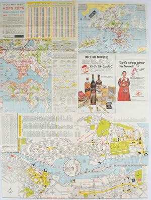
In den WarenkorbColoured tourist map brochure of maps of Hong Kong printed both sides (six maps in total), folded. Brochure also includes advertisements, currency rates. Minor tears along folds, otherwise in good condition. Text in traditional Chinese, English and Japanese. Sheet measures 58.2 x 43.4cm. Sheet includes 6 individual maps: Map of British Crown Colony of Hong Kong, Map of the Urban Area (with routes for public transportation), Map of Tsimshatsui (large scale street map), Map of Central District (large scale street map), Map of Wanchai (large scale street map), Map of Causeway Bay (large scale street map), Map of Portuguese Overseas Province of Macau. On the maps of Central and TST the names of many businesses, hotels, etc are marked.
-
A-O-A Map Sheet: Orientation Mini-maps.
Verlag: A-O-A Ltd. June/July1977., Hong Kong., 1977
Anbieter: Asia Bookroom ANZAAB/ILAB, Canberra, ACT, Australien
Verkõuferbewertung 5 von 5 Sternen
EUR 43,37
Wõhrung umrechnenEUR 25,56 f³r den Versand von Australien nach USAAnzahl: 1 verf³gbar
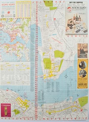
In den WarenkorbColoured tourist maps of Hong Kong printed both sides on a sheet, folded. One general area map of Hong Kong and three detailed street maps featuring Kowloon Peninsula, Tsimshatsui and Central District. Generally in very good condition, text in traditional Chinese, English and Japanese. Sheet measures 58.2 x 43cm. The tourist maps include currency rate, tourist advice, advertisements for foreign and local brands and shops (e.g. A-O-A Gambling Handbook for Macau, Duty Free shopping centres, Chinese Arts & Crafts centres, acupuncture clinic, etc.) The maps of Central and TST have the names of many hotels, businesses, post offices etc marked on them.