
Gesamtpreis (1 Artikel Artikel):
Versandziel:

winkles rapkin (8 Ergebnisse)
Feedback
Direkt zu den wichtigsten Suchergebnissen
Suchfilter
Produktart
- Alle Product Types
- Bücher (8)
- Magazine & Zeitschriften (Keine weiteren Ergebnisse entsprechen dieser Verfeinerung)
- Comics (Keine weiteren Ergebnisse entsprechen dieser Verfeinerung)
- Noten (Keine weiteren Ergebnisse entsprechen dieser Verfeinerung)
- Kunst, Grafik & Poster (Keine weiteren Ergebnisse entsprechen dieser Verfeinerung)
- Fotografien (Keine weiteren Ergebnisse entsprechen dieser Verfeinerung)
- Karten (Keine weiteren Ergebnisse entsprechen dieser Verfeinerung)
- Manuskripte & Papierantiquitäten (Keine weiteren Ergebnisse entsprechen dieser Verfeinerung)
Zustand
- Alle
- Neu (Keine weiteren Ergebnisse entsprechen dieser Verfeinerung)
- Antiquarisch (8)
Einband
- alle Einbände
- Hardcover (Keine weiteren Ergebnisse entsprechen dieser Verfeinerung)
- Softcover (2)
Weitere Eigenschaften
- Erstausgabe (2)
- Signiert (Keine weiteren Ergebnisse entsprechen dieser Verfeinerung)
- Schutzumschlag (Keine weiteren Ergebnisse entsprechen dieser Verfeinerung)
- Angebotsfoto (8)
Sprache (2)
Preis
- Beliebiger Preis
- Weniger als EUR 20 (Keine weiteren Ergebnisse entsprechen dieser Verfeinerung)
- EUR 20 bis EUR 45
- Mehr als EUR 45
Gratisversand
- Kostenloser Versand nach USA (Keine weiteren Ergebnisse entsprechen dieser Verfeinerung)
Land des Verkäufers
Verkäuferbewertung
-
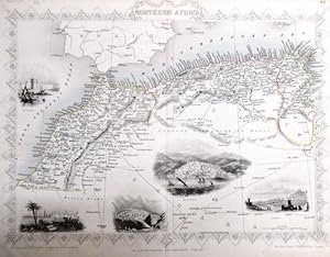
steal engraving / Grenzcolorierter Stahlstich Northern Africa. Mit weiteren 5 Bildstahlstichen 1)Mogador. 2) Marocco. 3) Constantine. 4) Algiers. 5)Tunis.
Verlag: The London Printing and Publishing Company. o.J. [ca 1850], 1850
Sprache: Englisch
Anbieter: Antiquariat Carl Wegner, Berlin, B, Deutschland
Verbandsmitglied: GIAQ
Verkäuferbewertung 5 von 5 Sternen

Erstausgabe
EUR 22,00
Währung umrechnenEUR 9,00 für den Versand von Deutschland nach USAAnzahl: 1 verfügbar
In den WarenkorbSoftcover. Blattgröße 27x36 cm, Stichgröße 21 x 30 cm, mittig längs gefaltet. Die Tafel mit floraler Rahmung, eingezeichneten Längen- und Breitengraden und Maßstabsangabe. Das Blatt an den Rändern und in der Querfalte leicht lichtrandig und fingerfleckig, an der linken unteren Ecke eine Faltstelle, sonst schönes Exemplar. --- In english language. Good condition. Die Tafel beschriftet mit der Ziffer 61. Wahrscheinlich die entsprechende Tafel aus dem Werk von John Tallis: Illustrated atlas and modern history of the world. -- Zu dekorativen Zwecken, zum Rahmen geeignet. Weitere Karten aus dem gleichen Werk vorhanden. "John Rapkin was a mapmaker who was concerned with the aesthetic value of his work as well as cartographic content. His fine maps are distinguished by the trademark decorative borders, vignettes and title displays. Rapkin worked in close association with the equally respected publisher John Tallis. The publishing rights of many of the maps passed to The London Printing and Publishing Company circa 1850. " -- Bitte Portokosten außerhalb EU erfragen! / Please ask for postage costs outside EU! / S ' il vous plait demander des frais de port en dehors de l ' UE! -- Genießen Sie den Frühling mit einem guten Buch ! GM25-502030.
-
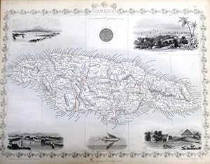
steal engraving / Grenzcolorierter Stahlstich Jamaica. Mit 6 weiteren BildStahlstichen 1) Port Royal Harbour. 2) Seal of the Colony. 3) Kingston. 4) Port Antonio. 5) Fliegender Fisch. 6) Sugar Mill.
Verlag: The London Printing and Publishing Company. o.J. [ca 1850], 1850
Sprache: Englisch
Anbieter: Antiquariat Carl Wegner, Berlin, B, Deutschland
Verbandsmitglied: GIAQ
Verkäuferbewertung 5 von 5 Sternen
Erstausgabe
EUR 36,00
Währung umrechnenEUR 9,00 für den Versand von Deutschland nach USAAnzahl: 1 verfügbar
In den WarenkorbSoftcover. Blattgröße 27x36 cm, Stichgröße 22 x 32 cm, mittig längs gefaltet. Die Tafel mit floraler Rahmung, eingezeichneten Längen- und Breitengraden und Maßstabsangabe. Das Blatt an den Rändern und in der Querfalte leicht lichtrandig sonst schönes Exemplar. --- In english language. Good condition. Die Tafel beschriftet mit der Ziffer 80. Wahrscheinlich die entsprechende Tafel aus dem Werk John Tallis: illustrated atlas and modern history of the world. -- Zu dekorativen Zwecken, zum Rahmen geeignet. Weitere Karten aus dem gleichen Werk vorhanden. "John Rapkin was a mapmaker who was concerned with the aesthetic value of his work as well as cartographic content. His fine maps are distinguished by the trademark decorative borders, vignettes and title displays. Rapkin worked in close association with the equally respected publisher John Tallis. The publishing rights of many of the maps passed to The London Printing and Publishing Company circa 1850. " -- Bitte Portokosten außerhalb EU erfragen! / Please ask for postage costs outside EU! / S ' il vous plait demander des frais de port en dehors de l ' UE! -- Genießen Sie den Frühling mit einem guten Buch ! GM25-502032.
-
"Islands in the Atlantic" mit Karte der Azoren, Kanarischen Inseln, Madeira, der Bermuda Inseln und der Kapverden sowie Ansichten von Fayal, Villa Franca und Pico (Azoren), Felsenkappelle von San Vicente, Funchal (Madeira) und Teneriffa (Kanarische Inseln). Aus: The Illustrated Atlas, And Modern History of the World Geographical, Political, Commercial & Statistical, Edited By R. Montgomery Martin, Esq.
Verlag: London & New York Rogers & Tallis, 1851
Sprache: Englisch
Anbieter: Versandantiquariat Christine Laist, Seeheim-Jugenheim, Deutschland
Verkäuferbewertung 5 von 5 Sternen
EUR 145,00
Währung umrechnenEUR 30,00 für den Versand von Deutschland nach USAAnzahl: 1 verfügbar
In den WarenkorbO-Stahlstichblatt aus dem "Illustrated Atlas" mit handkoloriertem floralverziertem Schmuckrahmen. Blatt mit sechs Karten der verschiedenen Inselgruppen im Atlantik nebst sechs Landschaftsansichten. Blattgröße: 27 x 37 cm.
-
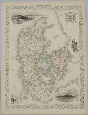
Denmark.
Verlag: John Tallis & Company. [Circa1850s]., London & New York., 1850
Anbieter: Asia Bookroom ANZAAB/ILAB, Canberra, ACT, Australien
Verkäuferbewertung 5 von 5 Sternen
EUR 101,90
Währung umrechnenEUR 18,81 für den Versand von Australien nach USAAnzahl: 1 verfügbar
In den WarenkorbLithographed map, with original outline hand colour, 34.5 x 24.7 cm (including border and captions),five fine vignette illustrations, decorative border, central fold, edges with light toning in very good condition. Attractive decorative map with fine vignettes of Copenhagen, Sleswig and Elsinore, figures in costume, the coat of arms of Denmark and an amiable equine pair by the great mapmaker and publisher John Tallis.
-
Black Sea
Verlag: Mar Nero
Anbieter: Sergio Trippini, Gavirate, Italien
Verkäuferbewertung 5 von 5 Sternen
EUR 80,00
Währung umrechnenEUR 46,00 für den Versand von Italien nach USAAnzahl: 1 verfügbar
In den WarenkorbCarta geografica del Mar Baltico, piccole vedute delle cittŕ di Sebastopoli, Varna, Odessa, Sinope, Costantinopoli e Silistria. Piega centrale editoriale.
-
The Crimea
Verlag: Crimea
Anbieter: Sergio Trippini, Gavirate, Italien
Verkäuferbewertung 5 von 5 Sternen
EUR 80,00
Währung umrechnenEUR 46,00 für den Versand von Italien nach USAAnzahl: 1 verfügbar
In den WarenkorbCarta geografica della penisola, piccole vedute delle cittŕ di Sebastopoli, Eupatoria, Balaklava, le secche di Alma e riquadro con topografia del porto di Sebastopoli. Piega centrale editoriale.
-
Baltic Sea
Verlag: Mar Baltico
Anbieter: Sergio Trippini, Gavirate, Italien
Verkäuferbewertung 5 von 5 Sternen
EUR 80,00
Währung umrechnenEUR 46,00 für den Versand von Italien nach USAAnzahl: 1 verfügbar
In den WarenkorbCarta geografica del Mar Baltico, piccole vedute delle cittŕ di Sanpietroburgo, Abo, Helsingfors, Kronstadt e Revel. Piega centrale editoriale.
-

Chili and La Plata
Verlag: The Illustrated Atlas and Modern History of the World, Geographical, Political, Commercial & Statistical. John Tallis & Company, 1850, 1850
Anbieter: Peter Harrington. ABA/ ILAB., London, Vereinigtes Königreich
Verbandsmitglied: ABA ILAB PBFA
Verkäuferbewertung 5 von 5 Sternen
EUR 115,08
Währung umrechnenEUR 16,47 für den Versand von Vereinigtes Königreich nach USAAnzahl: 1 verfügbar
In den WarenkorbA highly decorative map for the period with vignettes showing towns and local scenes, the whole enclosed in an elegant border. Steel engraving. In fine condition. Original colour.


