William slight (2 Ergebnisse)
Verlag: Published by authority of the Government. Under the direction of A.J. Skene, MA Surveyor General, The Hon. J. J. Casey, President, Board of Land and Works & Comr. of Lands & Survey, August 15th 1872., Melbourne,, 1872
Anbieter: Daniel Crouch Rare Books Ltd, London, Vereinigtes KönigreichDaniel Crouch Rare Books Ltd
Verkäufer/-in kontaktierenVerkäufer/-in mit 4 SternenZustand: Gebraucht
EUR 6.042,69
EUR 23,47 VersandVersand von Vereinigtes Königreich nach USAAnzahl: 1 verfügbar
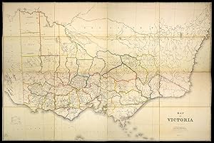
In den WarenkorbVictoria during the Gold Rush Large lithographed map with contemporary hand-colour in outline, dissected and laid down on linen, folding into green cloth covers, gilt A detailed map of the state of Victoria. At the time of printing, Victoria was a relatively new colony, established in 1851. The discovery of gold near Ballarat an…d Bendigo a few months later set off one of the largest gold rushes in history, as settlers poured in to seek their fortunes. The map reflects the colony's source of population and wealth, showing how settlements cluster around the gold fields. The map was commissioned and overseen by Alexander Skene and the Hon. J. J. Casey. Alexander Skene was a Scottish surveyor who had a prominent role in land distribution and regulation in Australia. The Hon. J. J. Casey was the Commissioner for Victoria at the time, a colourful figure who went on to become Minister for Justice. A contemporary newspaper reports in 1878 that Casey had complained that someone without a title had preceded him into dinner at the Paris Exposition Universelle, and had told the Prince of Wales himself that Victoria should be given more land. While his manner may have been distasteful, Casey's claim was built on a solid foundation. Gold exports from Victoria enabled Britain to clear all foreign debts by the end of the century, and the explosion in population, particularly in Melbourne, meant that it was one of the most successful new colonies. However, the growth in population also initiated demands for agricultural and political reform, policies aided by the accurate surveying and mapping of Victoria, and the ultimate aim of this map. Rare: known in only a handful of examples: the Beinecke, the NLA, the State Library of NSW, and the State Library of Victoria NLA MAP RM 1945; Tooley 898.

- Karte
Anbieter: Daniel Crouch Rare Books Ltd, London, Vereinigtes KönigreichDaniel Crouch Rare Books Ltd
Verkäufer/-in kontaktierenVerkäufer/-in mit 4 SternenZustand: Gebraucht
EUR 6.042,69
EUR 23,47 VersandVersand von Vereinigtes Königreich nach USAAnzahl: 1 verfügbar
In den Warenkorb"one of the most beautiful geological maps ever produced in Australia" (La Trobe) Revised. Six sheet colour printed lithograph map, joined and mounted on canvas. The third geological map of Australia after J. Beete Jukes (a modified Arrowsmith map dated 1850) and Robert Smyth (1873). It is based on Skene and Slight's earlier map… 'Continental Australia' (first published October 1879), with a second edition in 1880, followed by various editions, in whole or in part, including being used as the basis for the maps of each colony in the 'Sands Atlas' (1887). Brown reports that "at an 1880-81 exhibition in Melbourne, 'A Geological Sketch Map' of the continent, being the Skene map, hand coloured by Arthur Everett, Chief Draftsman of the Victorian Mining Department, was exhibited. The Department then went ahead with a printed version, as here, issued in November 188, on 6 sheets, printed in 11 colours at a price of £3/10/-. The 'Argus' (26 Nov 1887) commented that "as a specimen of lithographic printing, the map is a creditable work of art, the registry or joining of the various colours being free from overlaps and uncoloured areas". The 'La Trobe Journal' article of 2001 says that four editions of the maps were published in 1887-88, and refers to it as "one of the most beautiful geological maps ever produced in Australia". It comments that most of the known copies are varnished roll maps in poor condition, and that no copy seems to have been kept in the separate sheets as issued". Literature: Clancy, 'Maps that Shaped Australia', pages 17-23.
