Gesamtpreis (1 Artikel Artikel):
Versandziel:

warner beers (51 Ergebnisse)
Direkt zu den wichtigsten Suchergebnissen
Suchfilter
Produktart
- Alle Product Types
- Bücher (50)
- Magazine & Zeitschriften (Keine weiteren Ergebnisse entsprechen dieser Verfeinerung)
- Comics (Keine weiteren Ergebnisse entsprechen dieser Verfeinerung)
- Noten (Keine weiteren Ergebnisse entsprechen dieser Verfeinerung)
- Kunst, Grafik & Poster (Keine weiteren Ergebnisse entsprechen dieser Verfeinerung)
- Fotografien (Keine weiteren Ergebnisse entsprechen dieser Verfeinerung)
- Karten (1)
- Manuskripte & Papierantiquitäten (Keine weiteren Ergebnisse entsprechen dieser Verfeinerung)
Zustand Mehr dazu
- Neu (14)
- Wie Neu, Sehr Gut oder Gut Bis Sehr Gut (Keine weiteren Ergebnisse entsprechen dieser Verfeinerung)
- Gut oder Befriedigend (33)
- Ausreichend oder Schlecht (Keine weiteren Ergebnisse entsprechen dieser Verfeinerung)
- Wie beschrieben (4)
Einband
Weitere Eigenschaften
- Erstausgabe (2)
- Signiert (Keine weiteren Ergebnisse entsprechen dieser Verfeinerung)
- Schutzumschlag (Keine weiteren Ergebnisse entsprechen dieser Verfeinerung)
- Angebotsfoto (39)
Sprache (2)
Gratisversand
Land des Verkäufers
Verkäuferbewertung
-

Inside Secrets to Finding a Teaching Job
Anbieter: Better World Books: West, Reno, NV, USA
Verkäuferbewertung 5 von 5 Sternen

Zustand: Very Good. Former library copy. Pages intact with possible writing/highlighting. Binding strong with minor wear. Dust jackets/supplements may not be included. Includes library markings. Stock photo provided. Product includes identifying sticker. Better World Books: Buy Books. Do Good.
-
Inside Secrets to Finding a Teaching Job
Anbieter: Better World Books Ltd, Dunfermline, Vereinigtes Königreich
Verkäuferbewertung 5 von 5 Sternen
EUR 5,40
EUR 5,80 Versand
Versand von Vereinigtes Königreich nach USAAnzahl: 1 verfügbar
In den WarenkorbZustand: Good. Former library copy. Pages intact with minimal writing/highlighting. The binding may be loose and creased. Dust jackets/supplements are not included. Includes library markings. Stock photo provided. Product includes identifying sticker. Better World Books: Buy Books. Do Good.
-

History of Defiance County, Ohio
Anbieter: PBShop.store US, Wood Dale, IL, USA
Verkäuferbewertung 5 von 5 Sternen
PAP. Zustand: New. New Book. Shipped from UK. Established seller since 2000.
-
History of Defiance County, Ohio
Anbieter: PBShop.store UK, Fairford, GLOS, Vereinigtes Königreich
Verkäuferbewertung 4 von 5 Sternen

EUR 32,06
EUR 7,84 Versand
Versand von Vereinigtes Königreich nach USAAnzahl: 15 verfügbar
In den WarenkorbPAP. Zustand: New. New Book. Shipped from UK. Established seller since 2000.
-

History of Fayette County, Indiana: Containing a History of the Townships, Towns, Villages, Schools, Churches, Industries, etc.; Portraits of Early . and Prominent men; Biographies, etc., etc. .
Anbieter: Majestic Books, Hounslow, Vereinigtes Königreich
Verkäuferbewertung 4 von 5 Sternen
EUR 33,69
EUR 7,54 Versand
Versand von Vereinigtes Königreich nach USAAnzahl: 4 verfügbar
In den WarenkorbZustand: New.
-

History of Defiance County, Ohio Containing a History of the County, Its Townships, Towns Etc, Military Record, Portraits of Early Settlers and Personal Reminiscences Etc Classic Reprint
Anbieter: PBShop.store US, Wood Dale, IL, USA
Verkäuferbewertung 5 von 5 Sternen
HRD. Zustand: New. New Book. Shipped from UK. Established seller since 2000.
-
History of Defiance County, Ohio Containing a History of the County, Its Townships, Towns Etc, Military Record, Portraits of Early Settlers and Personal Reminiscences Etc Classic Reprint
Anbieter: PBShop.store UK, Fairford, GLOS, Vereinigtes Königreich
Verkäuferbewertung 4 von 5 Sternen
EUR 37,92
EUR 6,81 Versand
Versand von Vereinigtes Königreich nach USAAnzahl: 15 verfügbar
In den WarenkorbHRD. Zustand: New. New Book. Shipped from UK. Established seller since 2000.
-

EUR 29,49
EUR 48,99 Versand
Versand von Deutschland nach USAAnzahl: Mehr als 20 verfügbar
In den WarenkorbZustand: New.
-

EUR 41,95
EUR 48,99 Versand
Versand von Deutschland nach USAAnzahl: Mehr als 20 verfügbar
In den WarenkorbZustand: New.
-

Taschenbuch. Zustand: Neu. History of Fayette County, Indiana | containing a history of the townships, towns, villages, schools, churches, industries, etc.; portraits of early settlers and prominent men; biographies, etc., etc. | Beers and Co. Warner | Taschenbuch | 336 S. | Englisch | 2019 | hansebooks | EAN 9783337747053 | Verantwortliche Person für die EU: BoD - Books on Demand, In de Tarpen 42, 22848 Norderstedt, info[at]bod[dot]de | Anbieter: preigu.
-

History of Fayette County, Indiana : Containing a History of the Townships, Towns, Villages, Schools, Churches, Industries, etc.; Portraits of Early Settlers and Prominent men; Biographies, etc., etc. .
Sprache: Englisch
Verlag: Creative Media Partners, LLC Okt 2022, 2022
ISBN 10: 1015666167 ISBN 13: 9781015666160
Anbieter: AHA-BUCH GmbH, Einbeck, Deutschland
Verkäuferbewertung 5 von 5 Sternen
Taschenbuch. Zustand: Neu. Neuware.
-

History of Fayette County, Indiana : Containing a History of the Townships, Towns, Villages, Schools, Churches, Industries, etc.; Portraits of Early Settlers and Prominent men; Biographies, etc., etc. .
Sprache: Englisch
Verlag: Creative Media Partners, LLC Okt 2022, 2022
ISBN 10: 1015660657 ISBN 13: 9781015660656
Anbieter: AHA-BUCH GmbH, Einbeck, Deutschland
Verkäuferbewertung 5 von 5 Sternen
Buch. Zustand: Neu. Neuware.
-

History of Adams County, Pennsylvania
Sprache: Englisch
Verlag: SOUTHERN HISTORICAL PR INC, 2022
ISBN 10: 1639140840 ISBN 13: 9781639140848
EUR 68,10
EUR 48,99 Versand
Versand von Deutschland nach USAAnzahl: Mehr als 20 verfügbar
In den WarenkorbZustand: New. KlappentextBy: Warner, Beers & Company 1886, reprinted 2022, 756 pages, New Index, soft cover, ISBN #978-1-63914-084-8. Adams County was created in 1800 from York County which in turn was carved out of Lancaster County. It lies.
-

History of Cumberland County, Pennsylvania
Sprache: Englisch
Verlag: SOUTHERN HISTORICAL PR INC, 2022
ISBN 10: 1639140832 ISBN 13: 9781639140831
EUR 68,72
EUR 48,99 Versand
Versand von Deutschland nach USAAnzahl: Mehr als 20 verfügbar
In den WarenkorbZustand: New. KlappentextBy: Warner, Beers & Company 1886, reprinted 2022, 816 pages, New Index, soft cover, ISBN #978-1-63914-083-1. Cumberland County was created in 1750 from Lancaster County. It lies in the south-central portion of the st.
-

History of Adams County, Pennsylvania
Sprache: Englisch
Verlag: Southern Historical Press Nov 2022, 2022
ISBN 10: 1639140840 ISBN 13: 9781639140848
Anbieter: AHA-BUCH GmbH, Einbeck, Deutschland
Verkäuferbewertung 5 von 5 Sternen
Taschenbuch. Zustand: Neu. Neuware - By: Warner, Beers & Company 1886, reprinted 2022, 756 pages, New Index, soft cover, ISBN #978-1-63914-084-8.
-

History of Cumberland County, Pennsylvania
Sprache: Englisch
Verlag: Southern Historical Press Nov 2022, 2022
ISBN 10: 1639140832 ISBN 13: 9781639140831
Anbieter: AHA-BUCH GmbH, Einbeck, Deutschland
Verkäuferbewertung 5 von 5 Sternen
Taschenbuch. Zustand: Neu. Neuware - By: Warner, Beers & Company 1886, reprinted 2022, 816 pages, New Index, soft cover, ISBN #978-1-63914-083-1.
-

Plans of East Chester, Pelham, and New Rochelle
Verlag: F. W. Beers, New York, 1867
Anbieter: Antipodean Books, Maps & Prints, ABAA, Garrison, NY, USA
Verbandsmitglied: ABAA ANZAAB ESA ILAB
Verkäuferbewertung 3 von 5 Sternen

Zustand: Very good condition. 14.5 by 17.5 inches engraved map. This is from the Beers atlas.
-

Town of Yonkers
Verlag: F. W. Beers, New York, 1867
Anbieter: Antipodean Books, Maps & Prints, ABAA, Garrison, NY, USA
Verbandsmitglied: ABAA ANZAAB ESA ILAB
Verkäuferbewertung 3 von 5 Sternen
Zustand: Very good. 14.5 by 17.5 inches engraved map. This is from the Beers atlas that includes Westchester, Putnam & Dutchess County, which is unusual. Very good condition.
-
Town of Cortlandt. Original color map
Verlag: F. W. Beers, New York, 1867
Anbieter: Antipodean Books, Maps & Prints, ABAA, Garrison, NY, USA
Verbandsmitglied: ABAA ANZAAB ESA ILAB
Verkäuferbewertung 3 von 5 Sternen
Zustand: Very good overall. A lithograph map of this Westchester NY town, which extends from Peekskill down to Croton Point. From the Beers atlas that includes Westchester, Putnam & Dutchess County. 14.5 by 17.5".
-
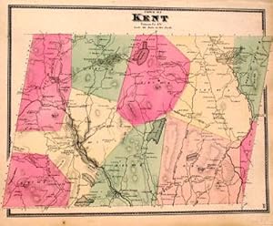
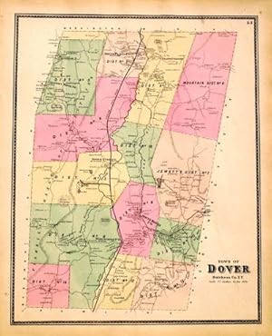
Town of Kent
Verlag: F. W. Beers, New York, 1867
Anbieter: Antipodean Books, Maps & Prints, ABAA, Garrison, NY, USA
Verbandsmitglied: ABAA ANZAAB ESA ILAB
Verkäuferbewertung 3 von 5 Sternen
Zustand: Very good. 14.5 by 17.5 inches engraved map. This is from the Beers atlas that includes Westchester, Putnam & Dutchess County, which is unusual. Very good condition.
-
The History of the County of Brant, Ontario
Verlag: Warner, Beers & Co, Toronto, 1883
Anbieter: Attic Books (ABAC, ILAB), London, ON, Kanada
Verkäuferbewertung 5 von 5 Sternen
Hardcover. Zustand: Very good. iv, [4], 689 p. 25 cm. 10 b&w portraits. Rebound in half burgundy leather with original black cloth. Light soiling to cloth. New endpapers. Repaired title page. A little light spotting and thumbing. Title continues: "Containing A History of the County; Its Townships, Cities, Towns, Schools, Churches, etc.; General and Local Statistics; Portraits of Early Settlers and Prominent Men; History of the Six Nation Indians and Captain Joseph Brant (Thayendanegea); History of the Dominion of Canada, Miscellaneous Matters; Etc., Etc., Etc." As its title indicates, a comprehensive history of Brant County until time of publication. Covers native history, the City of Brantford, township histories, biographies.
-
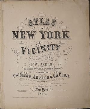
Atlas of New York and Vicinity. includes Dutchess County
Verlag: F.W. Beers, New York, 1867
Anbieter: Antipodean Books, Maps & Prints, ABAA, Garrison, NY, USA
Verbandsmitglied: ABAA ANZAAB ESA ILAB
Verkäuferbewertung 3 von 5 Sternen
Erstausgabe
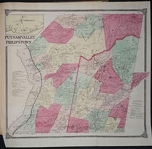
Hardcover. Zustand: Good + overall. First printing. Folio, 61 maps plus engraved table, many folding. This is a rare variant of the Beers atlas. Includes Westchester, Putnam & Dutchess County, which is unusual. 4pp lithographed prints of Bedford, Mahopac, North Salem. Maps include New York & Vicinity; New York, Brooklyn; West Farms, Westchester Morrisania; Town of Yonkers; City of Yonkers; Eastchester, Pelham & New Rochelle; Greenburgh; Beekman; Beekman Town; Mamaroneck, Scarsdale, White Plains; White Plains; Mt. Pleasant and Ossining; Borough of Sing Sing; Town of North Castle; Town of Newcastle, inset of Chappaqua; Bedford; Pound Ridge; Lewisboro incl. South Salem; Cortlandt; Peekskill; Yorktown; Somers & North Salem; Philipstown Putnam Valley; Cold Spring & Nelsonville; Carmel; Plan of Carmel Village; Southeast; Patterson & Brewsters Station; Patterson; Kent; Plan of Dutchess County; Plan of Fishkill; Plan of Mattewan; Plan of the Village of Fishkill; Wappingers Falls & Channingville; Town of East Fishkill; Beekman; Poughquag; Pawling; Town of Poughkeepskie; Plan of the City of Poughkeepsie; Town of LaGrange; Unionvale; Dover; Dover Plains & Pawling Station. Plan of the town of Hyde Park and Village of Staatsburg, Plans of the villages of Hyde Park and Pleasant Valley, Plan of the town of Pleasant Valley, Plan of the town of Washington, Plans of the villages of Washington, Mabbettsville, Hart's Village, Strandfordville and Bangall, Plan of the town of Amenia, Plans of the villages of Amenia, South Amenia, City of Amenia, Union, and Wassaic, Plan of the town of Clinton, Plan of the town of Strandford, Plans of the towns of Northeast and villages of Millerton including Manhattan Iron Works, Plan of the town of Rhinebeck, Plan of the borough of Rhinebeck, Plans of Rhinecliff and villages of Clinton Hollow and Clinton Corners, Plan of the town of Red Hook, Plans of the villages of Tivoli, Madalin, Barrytown, Annandale and Upper Red Hook, Plan of the village of Red Hook, Plans of the town of Milan and villages of Jackson's Corner, Milanville, Rock City and Lafayetteville, Plan of the town and village of Pine Plains. Also 5 lithographic illustrations of homes & farms. bound in rear. Map of NY on onion skin with a 12" closed tear, the rest of the folding maps (on onion skin) and the others (on cream paper) are in very nice condition. Orig. brown gilt stamped cloth boards marked, rubbed, black leather spine rubbed. Light damp mark on engravings at the back. Foxing in early margins.
-
Atlas of New York and Vicinity. includes Dutchess County
Verlag: F. W. Beers, A. D. Ellis, & G. G. Soule, New York, 1867
Anbieter: Antipodean Books, Maps & Prints, ABAA, Garrison, NY, USA
Verbandsmitglied: ABAA ANZAAB ESA ILAB
Verkäuferbewertung 3 von 5 Sternen
Erstausgabe
Hardcover. Zustand: Very good condition. First printing. A highly unusual variant of Beers atlas of New York, with many maps of Dutchess County. Folio, 44 maps, many folding. Includes Westchester, Putnam & lower Dutchess County, which is unusual. A nice clean copy. Folding maps on onion skin paper, in very good condition. Original publishers binding but with amateur rebacking with dark brown cloth. Gilt bright, corners rubbed. The New York general map and the Fishkill map are loose. A very tight and clean copy. Maps include New York & Vicinity; New York & Brooklyn; Westchester, West Farms (Brooklyn), Morrisania; Town of Yonkers; City of Yonkers; Eastchester, Pelham & New Rochelle; Greenburgh; Plan of Beekmantown, Tarrytown & Irving; Mamaroneck, Scarsdale, White Plains; White Plains; Mt. Pleasant and Ossining; Borough of Sing Sing; Town of North Castle; Town of Newcastle, inset of Chappaqua; Bedford; Pound Ridge; Lewisboro incl. South Salem; Cortlandt; Peekskill; Yorktown; Somers & North Salem; Philipstown Putnam Valley; Cold Spring & Nelsonville; Carmel (insetsof Towners Station, Southeast Center & Millton); Town of South-East; Brewsters Station & Patterson; Plan of the Town of Patterson; Kent; Outline Plan of Dutchess County; Plan of Fishkill; Plan of Matteawan & Fishkill; Plan of the Village of Fishkill; Wappingers Falls & Channingville; Town of East Fishkill; Plan of the town of Beekman & villages of Beekmanville, Poughquag & Greenhaven; Pawling; Town of Poughkeepsie; Plan of the city of Poughkeepsie; Town of LaGrange; Unionvale; Dover, Dover Plains, South Dover & Pawling Station. Also 11 lithographic illustrations of home & farms on 4pp.
-
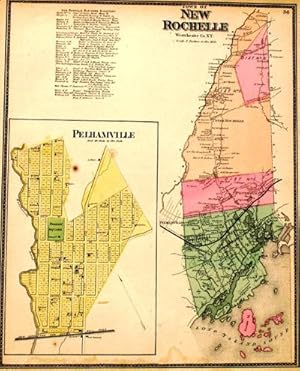
Town of New Rochelle
Verlag: F. W. Beers, New York, 1867
Anbieter: Antipodean Books, Maps & Prints, ABAA, Garrison, NY, USA
Verbandsmitglied: ABAA ANZAAB ESA ILAB
Verkäuferbewertung 3 von 5 Sternen
Zustand: Very good. 14.5 by 17.5 inches engraved map. Includes a view of Pelhamville. This is from the Beers atlas that includes Westchester, Putnam & Dutchess County, which is unusual. Very good condition.
-
Town of Beekman
Verlag: F. W. Beers, New York, 1867
Anbieter: Antipodean Books, Maps & Prints, ABAA, Garrison, NY, USA
Verbandsmitglied: ABAA ANZAAB ESA ILAB
Verkäuferbewertung 3 von 5 Sternen
Zustand: Very good. 14.5 by 17.5 inches engraved map which includes views of Poughquag, Beekmanville, and Green Haven. This is from the Beers atlas that includes Westchester, Putnam & Dutchess County, which is unusual. Very good condition.
-
Zustand: Very good. 14.5 by 17.5 inches engraved map. This is from the Beers atlas that includes Westchester, Putnam & Dutchess County, which is unusual. Very good condition.
-
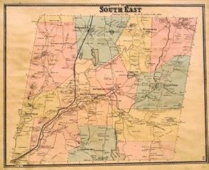
Town of South East
Verlag: F. W. Beers, New York, 1867
Anbieter: Antipodean Books, Maps & Prints, ABAA, Garrison, NY, USA
Verbandsmitglied: ABAA ANZAAB ESA ILAB
Verkäuferbewertung 3 von 5 Sternen
Zustand: Very good. 14.5 by 17.5 inches engraved map. This is from the Beers atlas that includes Westchester, Putnam & Dutchess County, which is unusual. Very good condition.
-
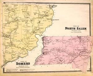
Town of Somers, Town of North Salem
Verlag: F. W. Beers, New York, 1867
Anbieter: Antipodean Books, Maps & Prints, ABAA, Garrison, NY, USA
Verbandsmitglied: ABAA ANZAAB ESA ILAB
Verkäuferbewertung 3 von 5 Sternen
Zustand: Very good. 14.5 by 17.5 inches engraved map. This is from the Beers atlas that includes Westchester, Putnam & Dutchess County, which is unusual. Very good condition.
-
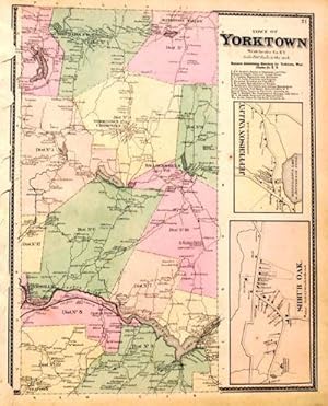
Town of Yorktown
Verlag: F. W. Beers, New York, 1867
Anbieter: Antipodean Books, Maps & Prints, ABAA, Garrison, NY, USA
Verbandsmitglied: ABAA ANZAAB ESA ILAB
Verkäuferbewertung 3 von 5 Sternen
Zustand: Very good. 14.5 by 17.5 inches engraved map. This is from the Beers atlas that includes Westchester, Putnam & Dutchess County, which is unusual. Very good condition.
-
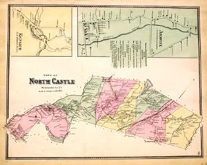
Town of North Castle, Including Armonk and Kensico
Verlag: F. W. Beers, New York, 1867
Anbieter: Antipodean Books, Maps & Prints, ABAA, Garrison, NY, USA
Verbandsmitglied: ABAA ANZAAB ESA ILAB
Verkäuferbewertung 3 von 5 Sternen
Zustand: Very good. 14.5 by 17.5 inches engraved map. This is from the Beers atlas that includes Westchester, Putnam & Dutchess County, which is unusual. Very good condition.