
Gesamtpreis (1 Artikel Artikel):
Versandziel:

waldseemüller martin (39 Ergebnisse)
Feedback
Direkt zu den wichtigsten Suchergebnissen
Suchfilter
Produktart
- Alle Product Types
- Bücher (27)
- Magazine & Zeitschriften (Keine weiteren Ergebnisse entsprechen dieser Verfeinerung)
- Comics (Keine weiteren Ergebnisse entsprechen dieser Verfeinerung)
- Noten (Keine weiteren Ergebnisse entsprechen dieser Verfeinerung)
- Kunst, Grafik & Poster (Keine weiteren Ergebnisse entsprechen dieser Verfeinerung)
- Fotografien (Keine weiteren Ergebnisse entsprechen dieser Verfeinerung)
- Karten (12)
- Manuskripte & Papierantiquitäten (Keine weiteren Ergebnisse entsprechen dieser Verfeinerung)
Zustand
Weitere Eigenschaften
- Erstausgabe (Keine weiteren Ergebnisse entsprechen dieser Verfeinerung)
- Signiert (Keine weiteren Ergebnisse entsprechen dieser Verfeinerung)
- Schutzumschlag (Keine weiteren Ergebnisse entsprechen dieser Verfeinerung)
- Angebotsfoto (21)
Sprache (5)
Gratisversand
Land des Verkäufers
Verkäuferbewertung
-

Time Warping for Beginners
Verlag: CreateSpace Independent Publishing Platform, 2018
ISBN 10: 1721080252 ISBN 13: 9781721080250
Sprache: Englisch
Anbieter: Ria Christie Collections, Uxbridge, Vereinigtes Königreich
Verkäuferbewertung 5 von 5 Sternen

EUR 9,34
Währung umrechnenEUR 5,91 für den Versand von Vereinigtes Königreich nach DeutschlandAnzahl: Mehr als 20 verfügbar
In den WarenkorbZustand: New. Waldseemuller, Martin; Ringmann, Mathias; Ribero, Diego (illustrator). In.
-

EUR 19,50
Währung umrechnenKostenlos für den Versand innerhalb von/der DeutschlandAnzahl: 5 verfügbar
In den WarenkorbTaschenbuch. Zustand: Neu. Die Cosmographiae Introductio des Martin Waldseemüller | Martin Waldseemüller (u. a.) | Taschenbuch | Deutsch | Inktank-Publishing | EAN 9783750918535 | Verantwortliche Person für die EU: Inktank-Publishing, Konsul-Smidt-Str. 92, 28217 Bremen, maruhn[at]musketierverlag[dot]de | Anbieter: preigu.
-

EUR 19,96
Währung umrechnenKostenlos für den Versand innerhalb von/der DeutschlandAnzahl: Mehr als 20 verfügbar
In den WarenkorbZustand: New.
-

Die Cosmographiae Introductio Des Martin Waldseemüller (Ilacomilus) in Faksimiledruck (German Edition)
Anbieter: Ria Christie Collections, Uxbridge, Vereinigtes Königreich
Verkäuferbewertung 5 von 5 Sternen
EUR 17,75
Währung umrechnenEUR 5,91 für den Versand von Vereinigtes Königreich nach DeutschlandAnzahl: Mehr als 20 verfügbar
In den WarenkorbZustand: New. In.
-

EUR 28,32
Währung umrechnenKostenlos für den Versand innerhalb von/der DeutschlandAnzahl: Mehr als 20 verfügbar
In den WarenkorbKartoniert / Broschiert. Zustand: New.
-

The Cosmographić Introductio Of Martin Waldseemüller In Facsimile: Followed By The Four Voyages Of Amerigo Vespucci, With Their Translation Into English
Anbieter: Ria Christie Collections, Uxbridge, Vereinigtes Königreich
Verkäuferbewertung 5 von 5 Sternen
EUR 24,89
Währung umrechnenEUR 5,91 für den Versand von Vereinigtes Königreich nach DeutschlandAnzahl: Mehr als 20 verfügbar
In den WarenkorbZustand: New. In.
-

Die Cosmographiae Introductio Des Martin Waldseemüller (Ilacomilus) in Faksimiledruck (German Edition)
Anbieter: Ria Christie Collections, Uxbridge, Vereinigtes Königreich
Verkäuferbewertung 5 von 5 Sternen
EUR 31,56
Währung umrechnenEUR 5,91 für den Versand von Vereinigtes Königreich nach DeutschlandAnzahl: Mehr als 20 verfügbar
In den WarenkorbZustand: New. In.
-

EUR 21,24
Währung umrechnenEUR 7,43 für den Versand von Kanada nach DeutschlandAnzahl: 1 verfügbar
In den WarenkorbHardcover. Zustand: New. Size of the book: US Trade 152 x 229 mm and around 200 Cream color pages.
-

Cosmographiae Introductio Cum Quibusdam Geometriae Ac Astronomiae Principijs Ad Eam Rem Necessarijs Classic Reprint
Anbieter: PBShop.store UK, Fairford, GLOS, Vereinigtes Königreich
Verkäuferbewertung 4 von 5 Sternen

EUR 18,56
Währung umrechnenEUR 4,60 für den Versand von Vereinigtes Königreich nach DeutschlandAnzahl: 15 verfügbar
In den WarenkorbPAP. Zustand: New. New Book. Shipped from UK. Established seller since 2000.
-

EUR 22,61
Währung umrechnenKostenlos für den Versand innerhalb von/der DeutschlandAnzahl: Mehr als 20 verfügbar
In den WarenkorbZustand: New.
-

Die Cosmographiae Introductio Des Martin Waldseemller Ilacomilus In Faksimiledruck Herausgegeben Mit Einer Einleitung Classic Reprint
Anbieter: PBShop.store UK, Fairford, GLOS, Vereinigtes Königreich
Verkäuferbewertung 4 von 5 Sternen
EUR 19,55
Währung umrechnenEUR 4,60 für den Versand von Vereinigtes Königreich nach DeutschlandAnzahl: 15 verfügbar
In den WarenkorbPAP. Zustand: New. New Book. Shipped from UK. Established seller since 2000.
-

EUR 40,14
Währung umrechnenKostenlos für den Versand innerhalb von/der DeutschlandAnzahl: Mehr als 20 verfügbar
In den WarenkorbGebunden. Zustand: New.
-

The Cosmographić Introductio Of Martin Waldseemüller In Facsimile: Followed By The Four Voyages Of Amerigo Vespucci, With Their Translation Into English
Anbieter: Ria Christie Collections, Uxbridge, Vereinigtes Königreich
Verkäuferbewertung 5 von 5 Sternen
EUR 34,91
Währung umrechnenEUR 5,91 für den Versand von Vereinigtes Königreich nach DeutschlandAnzahl: Mehr als 20 verfügbar
In den WarenkorbZustand: New. In.
-

EUR 29,10
Währung umrechnenKostenlos für den Versand innerhalb von/der DeutschlandAnzahl: Mehr als 20 verfügbar
In den WarenkorbGebunden. Zustand: New. KlappentextrnrnExcerpt from Die Cosmographiae Introductio Des Martin Waldseemueller (Ilacomilus): In Faksimiledruck Herausgegeben Mit Einer EinleitungDiese umfangreiche, so wel des Neuen und Interessanten bietende Publikation wurde bei Ge.
-

THE COSMOGRAPHIĆ INTRODUCTION. Followed by the Four Voyages of Amerigo Vespucci, with their Translation into English; to which are added Waldseemüller's Two World Maps of 1507. With an Introduction by Prof. Joseph Fischer and Prof. Franz von Wieser. Edited by Prof. Charles George Herbermann.
Verlag: Books for Libraries Press New York, 1969
Anbieter: Francis Edwards ABA ILAB, Hay on Wye, Vereinigtes Königreich
Verbandsmitglied: ABA ILAB PBFA
Verkäuferbewertung 5 von 5 Sternen
EUR 26,88
Währung umrechnenEUR 14,83 für den Versand von Vereinigtes Königreich nach DeutschlandAnzahl: 1 verfügbar
In den WarenkorbReprint. [viii] + 30pp. + [civ] + (31-151)pp. + [i]. 4 folding plates, diagrams. From the library of Ann Savours Shirley with inscription, original gilt lettered brown cloth. Select Bibliographies Reprint Series. US$30.
-
Cosmographiae Introductio
Verlag: Readex Microprint
Anbieter: Powell's Bookstores Chicago, ABAA, Chicago, IL, USA
Verkäuferbewertung 5 von 5 Sternen
EUR 30,21
Währung umrechnenEUR 15,32 für den Versand von USA nach DeutschlandAnzahl: 1 verfügbar
In den WarenkorbZustand: Used - Very Good. 1966. Cloth, 151 pp., illus. Facsimile of the edition of 1507.
-
Cosmographiae Introductio
Verlag: University Microfilms
Anbieter: Wonder Book, Frederick, MD, USA
Verkäuferbewertung 5 von 5 Sternen
EUR 17,99
Währung umrechnenEUR 21,89 für den Versand von USA nach DeutschlandAnzahl: 1 verfügbar
In den WarenkorbZustand: Fair. Acceptable condition. Former Library book. March of America Facsimile Series, 2. Latin and English edition. (America, Discovery, Exploration, Books in Latin) A readable, intact copy that may have noticeable tears and wear to the spine. All pages of text are present, but they may include extensive notes and highlighting or be heavily stained. Includes reading copy only books.
-
Cosmographiae Introductio
Verlag: University Microfilms
Anbieter: Wonder Book, Frederick, MD, USA
Verkäuferbewertung 5 von 5 Sternen
EUR 21,37
Währung umrechnenEUR 21,89 für den Versand von USA nach DeutschlandAnzahl: 1 verfügbar
In den WarenkorbZustand: Fair. Acceptable condition. Former Library book. (geography, early works to 1800, america, discovery and exploration) A readable, intact copy that may have noticeable tears and wear to the spine. All pages of text are present, but they may include extensive notes and highlighting or be heavily stained. Includes reading copy only books.
-

The Naming of America: Martin Waldseemuller's 1507 World Map and the Cosmographiae Introduction
Anbieter: Revaluation Books, Exeter, Vereinigtes Königreich
Verkäuferbewertung 5 von 5 Sternen
EUR 74,84
Währung umrechnenEUR 11,86 für den Versand von Vereinigtes Königreich nach DeutschlandAnzahl: 1 verfügbar
In den WarenkorbHardcover. Zustand: Brand New. 121 pages. 9.25x7.75x0.75 inches. In Stock.
-
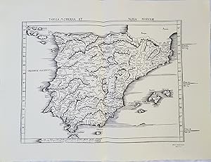
Mapa - Map : TABULA MODERNA ET NOVA HISPANIAE (Reproducción)
Verlag: Ed, Estrasburgo, 1513
Anbieter: LIBRERÍA MAESTRO GOZALBO, Carcaixent, Spanien
Verkäuferbewertung 5 von 5 Sternen
Karte
EUR 37,40
Währung umrechnenEUR 21,90 für den Versand von Spanien nach DeutschlandAnzahl: 1 verfügbar
In den WarenkorbZustand: Buen estado. 1 lámina sin enmarcar Buen estado Está basado en el primer mapa moderno impreso de Espańa incluido en la Geographia publicada en Ulm en 1482. Pertenece a la edición de la Geografía de Ptolomeo realizada por Waldseemüller y publicada en Estrasburgo en 1513.
-

Mapa - Map : TABULA MODERNA ET NOVA HISPANIAE (Facsímil)
Verlag: Ed, Estrasburgo, 1513
Anbieter: LIBRERÍA MAESTRO GOZALBO, Carcaixent, Spanien
Verkäuferbewertung 5 von 5 Sternen
Karte
EUR 44,25
Währung umrechnenEUR 21,90 für den Versand von Spanien nach DeutschlandAnzahl: 1 verfügbar
In den WarenkorbZustand: Buen estado. 1 lámina sin enmarcar Buen estado Está basado en el primer mapa moderno impreso de Espańa incluido en la Geographia publicada en Ulm en 1482. Pertenece a la edición de la Geografía de Ptolomeo realizada por Waldseemüller y publicada en Estrasburgo en 1513.
-
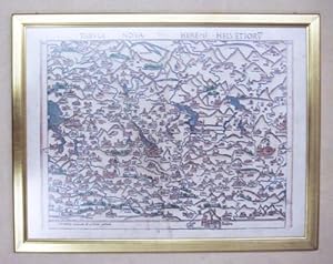
Tabula Nova Heremi Helvetiorum. Holzschnitt (Faksimile).
Verlag: / 1986, 1732
Sprache: Deutsch
Anbieter: antiquariat peter petrej - Bibliopolium AG, Zürich, ZH, Schweiz
Verkäuferbewertung 4 von 5 Sternen
EUR 467,34
Währung umrechnenEUR 28,00 für den Versand von Schweiz nach DeutschlandAnzahl: 1 verfügbar
In den Warenkorb53 x 67 cm, gerahmt., 43 x 56 cm, Tabula nova Heremi Helvetiorum von Martin Waldseemüller (um 1472?1520) stammt aus der Ptolemäusausgabe die 1513 in Strassburg bei Schott gedruckt wurde. Südorientierte Karte der Deutsch-Schweiz. Martin Waldseemüller (auch Waltzemüller, gräzisiert Hylacomylus oder Ilacomilus; * um 1472/1475 in Wolfenweiler bei Freiburg im Breisgau; ? 16. März 1520 in Sankt Didel) deutscher Kartograf der Renaissance. Er erstellte die erste Weltkarte, auf der die Landmassen im Westen nach Amerigo Vespucci mit dem Namen ?America? bezeichnet wurden. (Blumer, Bibliographie der Gesamtkarten, 32-33, Nr. 2) 2200 gr. Schlagworte: Reisen - Karten, Panoramen, Helvetica - Allgemein.
-
Introducción a la Cosmografía y las Cuatro Navegaciones de Américo Vespucio.
Verlag: Universidad Nacional Autónoma de México, México, 2007
Anbieter: Librería José Porrúa Turanzas S.A., Madrid, Spanien
Verkäuferbewertung 4 von 5 Sternen
EUR 100,00
Währung umrechnenEUR 15,00 für den Versand von Spanien nach DeutschlandAnzahl: 1 verfügbar
In den WarenkorbFirst Edition - Primera edición. México, Universidad Nacional Autónoma de México, 2007. 3 volúmenes. En 4ş (235 x 160)mm. -I: Facsímil en Latín: ciii-2 láminas plegados en blanco y negro. -II: Traducción del Latín: 147 pp., (5) h. -III: Carpeta con CD y mapa plegado. Facsimil de la edición príncipe de 1507 de la introducción a la cosmografía de Waldseemüller. En 1505, Mathias Ringmann y Martin Waldseemüller se dieron a la tarea de realizar una nueva edición de la Geographia de Ptolomeo que superara a las anteriores y que incluyera la mayor cantidad posible de noticias derivadas de los nuevos descubrimientos geográficos. Por ese tiempo llegó a sus manos un ejemplar del Mundus novus escrito por Américo Vespucio. La lectura de este texto los entusiasmó tanto que, sin abandonar la idea de la nueva edición de la Geographia, se decidió preparar antes un mapamundi. Para facilitar la lectura de este mapa, Martin Waldseemüller escribió la Cosmographiae introdutio y decidió incluir en ella, para dar credibilidad al mapa, la traducción al latín de las Cuatro navegaciones. Hoy, en conmemoración de los 500 ańos de esta obra, se presenta una edición en espańol con notas y un estudio introductorio del doctor Miguel León-Portilla. En esta ocasión se incluyen también los facsímiles de la Cosmographiae introductio y el mapamundi de Waldseemüller, tanto en impreso como en versión digital. 235x160mm. (9Ľx6Ľ").
-
Die älteste Karte mit dem Namen Amerika aus dem Jahre 1507 und die Carta Marina aus dem Jahre 1516 des M. Waldseemüller (Ilacomilus) / The oldest map with the name America and the carta marina of the year 1516 by M. Waldseemüller (Ilacomus) / hrsg. von Jos Fischer und Fr. R. von Wieser.
Anbieter: Antiquariaat A. Kok & Zn. B.V., Amsterdam, Niederlande
Verkäuferbewertung 4 von 5 Sternen
EUR 110,00
Währung umrechnenEUR 15,95 für den Versand von Niederlande nach DeutschlandAnzahl: 1 verfügbar
In den Warenkorb[Innsbruck, 1903] Reprint Amst., 1968. [3],55 pp. 27 double-page b./w. plates (numbered 1-20, 20a, 21-26), 2 synoptical tables of topographical names in Africa and America illustrating the relation of the two maps to several other maps before 1516 & several further reproductions illustrating the 41-page introduction in German with a parallel English translation. Nicely re-bound in modern hardcover (dark blue linen, gilt lettered burgundy red label on the spine). Folio. (Theatrum Orbis Terrarum).A reprint of the facsimile edition of 1903 containing the two monumental wall maps by Martin Waldseemüller (1470-1521), published in 1507 and 1516. Both are reproduced in ca. 1903 from the only surviving copies in the library of Wolfegg Castle in Württemberg. A single copy of the 1507 map survived, presently housed at the Library of Congress in Washington. The Waldseemüller map, Universalis Cosmographia, is a printed wall map of the world by German cartographer Martin Waldseemüller, originally published in April 1507. It is known as the first map to use the name "America". Its main map, and his globe gores of the same date, depict the American continents in two pieces. These depictions differ from the small inset map in the top border, which shows the two American continents joined by an isthmus. The name America is placed on what is now called South America on the main map, this being the first map known to use this name. As explained in Cosmographiae Introductio, the name was bestowed in honor of the Italian Amerigo Vespucci. The map is drafted on a modification of Ptolemy's second projection, expanded to accommodate the Americas and the high latitudes. [Source: Wikipedia].
-
![Bild des Verkäufers für Universalis Cosmographia Secundum Ptolomaei Traditionem et Americi Vespucii Alior[m]que Lustrationes zum Verkauf von Delirium Books · Susana Bardón](https://pictures.abebooks.com/inventory/md/md32219276644.jpg)
Universalis Cosmographia Secundum Ptolomaei Traditionem et Americi Vespucii Alior[m]que Lustrationes
Verlag: Madrid, 1959
Anbieter: Delirium Books · Susana Bardón, Madrid, Spanien
Verkäuferbewertung 4 von 5 Sternen
Karte
EUR 900,00
Währung umrechnenEUR 15,00 für den Versand von Spanien nach DeutschlandAnzahl: 1 verfügbar
In den WarenkorbSin Encuadernar. Zustand: Como Nuevo. El mapa que cambió la percepción del mundo. Mapamundi mural, de 230 x 130 cm., estampado en 12 hojas de formato 48 x 65 cm., que una vez unidas forman la representación del mundo conocida a principios del siglo XVI. Reproducción FACSIMILAR a tamańo real del mapa planisferio de Walsemuller probablemente la obra más icónica de la historia de la cartografía publicado originariamente en 1507. Fue el primer mapa en emplear el nombre de América para designar al continente recién descubierto, en honor a Americo Vespucio. En la parte superior incluye dos medallones: uno con Asia, África y Europa junto a un retrato de Ptolomeo, y otro con América junto a un retrato de Vespucio. Marcó un hito en su momento pues fue el primero en mostrar América como un continente separado de Asia y el primero en introducir el nombre de América. Se cree que se imprimieron 1000 ejemplares en su momento pero a día de hoy tan solo se conserva un ejemplar en la Biblioteca del Congreso en los Estados Unidos. Esta edición facsímil, realizada en Madrid corrió a cargo del editor e historiador Carlos Sanz.
-
Octava Asie Tabvla
Verlag: J. Schott, 1513
Anbieter: Antiquariaat Dat Narrenschip, Middelburg, Niederlande
Verkäuferbewertung 5 von 5 Sternen
Karte
EUR 2.600,00
Währung umrechnenEUR 16,00 für den Versand von Niederlande nach DeutschlandAnzahl: 1 verfügbar
In den WarenkorbNo Binding. Zustand: Very Good. Trapezoidal map of the eastern part of Central Asia with the western part of China to the east. The Central Asian steppe, formerly Schytia Extra Imaum. This map by Martin Waldseemüller is based on Claudius Ptolemy (87-150), the famous geographer of Antiquity. Some minor spots on the margins. Woodcut, published in Strasbourg in 1513 by J. Schott in "Claudii Ptolemei viri Alexandrini Mathematical discipline Philosophi dictissimi Geographiae opus novissima (.)." Dimensions (picture): 37 x 52 cm.
-
Tabula nova Asiae minoris.
Verlag: Gaspar Trechsel, 1541
Anbieter: Antiquariaat Dat Narrenschip, Middelburg, Niederlande
Verkäuferbewertung 5 von 5 Sternen
Karte
EUR 650,00
Währung umrechnenEUR 16,00 für den Versand von Niederlande nach DeutschlandAnzahl: 1 verfügbar
In den WarenkorbNo Binding. Zustand: Very Good. Antique map of Asia Minor and Cyprus. Cartographer: Martin Waldseemuller. Based on Ptolemy. Woodcut, published in Vienne in 1541 by Gaspar Trechsel in "Claudii Ptolemaei Alexandrini Geographicae Enarrationis, Libri Octo, (.)" Dimensions (picture): 28 x 37 cm.
-
Tabula Terrae Novae
Verlag: Michael Servetus, Vienna, 1541
Anbieter: Alexandre Antique Prints, Maps & Books, Toronto, ON, Kanada
Verkäuferbewertung 2 von 5 Sternen

Karte
EUR 11.723,28
Währung umrechnenEUR 7,44 für den Versand von Kanada nach DeutschlandAnzahl: 1 verfügbar
In den WarenkorbZustand: Very Good. Latin Text on verso.An important early map of the Americas by Martin Waldseemüller which was first published in 1513 and later, on 1522 and onwards Laurent Fries republished it. The last 2 editions were published by Michael Servetus who was burn alive for heresy. The text on the reverse of the maps in the last 2 editions ends with a protest against the use of name America for the new world.Lorenz (Laurent) Fries (c.1490 - c.1531) was a physician, astrologer and geographer born in Alsace. After studying medicine and spending time at several European universities, he settled in Strasbourg where he met publisher and printer Johann Grüninger. With Grüninger, he worked on a new edition of Ptolemy's "Geographia" with woodcut maps reduced from Martin Waldseemuller's "Geographie Opus Novissima", which were published in various editions from 1522 - 1541, even after Fries died., Size : 285x375 (mm), 11.22x14.76 (Inches), Hand Colored, 0.
-
(Stolen)Nona Euro Pe Tabula
Verlag: Martin Waldseemuller c. 1513, Strasburg, 1513
Anbieter: Alexandre Antique Prints, Maps & Books, Toronto, ON, Kanada
Verkäuferbewertung 2 von 5 Sternen
Karte
EUR 5.861,64
Währung umrechnenEUR 7,44 für den Versand von Kanada nach DeutschlandAnzahl: 1 verfügbar
In den WarenkorbZustand: Excellent. (Stolen)A fine and strong impression of this rare map of Eastern Europe from the 1513 edition of Waldseemüller's modern atlas Geographia.The verso is blank. The watermark is similar to fleur de lis sitting on a multi headed star.Large Ptolemaic map depicting Europe and Balkan from the Adriatic Sea to the Black Sea.The Atlas ' GEOGRAPHIE OPUS NOVISSIMA TRADUCTIONE E GRECORUM ARCHETYPIS ' one of the most important edition of Ptolemy Atlases.was published by Johannes Schott in Strasburg 1513., Size : 434x618 (mm), 17.09x24.33 (Inches), Black & White.
-
![Bild des Verkäufers für [Tabula Terrae Novae .] zum Verkauf von Altea Antique Maps](https://pictures.abebooks.com/inventory/md/md31449518973.jpg)
[Tabula Terrae Novae .]
Erscheinungsdatum: 1541
Anbieter: Altea Antique Maps, London, Vereinigtes Königreich
Verbandsmitglied: ABA ILAB PBFA
Verkäuferbewertung 5 von 5 Sternen
Karte
EUR 10.387,31
Währung umrechnenEUR 29,66 für den Versand von Vereinigtes Königreich nach DeutschlandAnzahl: 1 verfügbar
In den WarenkorbVienne: Gaspar Treschel, 1541. Woodcut, printed area 285 x 430mm. A fine example of one of the earliest obtainable maps to show the New World, this example being the fourth and last issue of the Fries reduction of Wäldseemüller's famous map, which is the first printed atlas map devoted to the Americas and said to have been compiled with the assistance of Columbus himself. It shows the eastern coasts of America and the western coast of Europe & Africa 55ş North to 35ş South, with a rudimentary 'Florida', Cuba, Hispaniola and Jamaica. In his version Fries added a Spanish flag over Cuba and a vignette scene in South America depicting cannibals and an opossum, both reported by Vespucci. It was Wäldseemüller's world map of 1507 that first used the name 'America', placing in southern South America, after Vespucci, who explored that region and proved it was not part of Asia. When the name began to be used for the entire landmass Wäldseemüller used this map to emphasise Columbus's importance: a Latin text above 'Terra Nova' reads 'This land and the adjacent islands were discovered by Christopher Columbus on the mandate of the King of Castile'. This map was originally intended not for an edition of Ptolemy but for a new 'Chronica mundi' being written by Wäldseemüller: his death c.1520 caused the project to be shelved, so the woodcuts were used to publish a smaller sized and so cheaper edition of the 'Geography'. The title, as above, is on the reverse. This edition was one of two with a text edited by Michael Servetus, who would later be burned at the stake for heresy, on a pyre of his own books, on the behest of John Calvin. BURDEN: 4.


