
Gesamtpreis (1 Artikel Artikel):
Versandziel:

thomas abel brimage spratt after (1 Ergebnisse)
Direkt zu den wichtigsten Suchergebnissen
Produktart
- Alle Produktarten
- B³cher
- Magazine & Zeitschriften
- Comics
- Noten
- Kunst, Grafik & Poster
- Fotografien
- Karten (1)
-
Manuskripte &
Papierantiquitõten
Zustand
- Alle
- Neu
- Antiquarisch/Gebraucht
Einband
- alle Einbõnde
- Hardcover
- Softcover
Weitere Eigenschaften
- Erstausgabe
- Signiert
- Schutzumschlag
- Angebotsfoto
Land des Verkõufers
Verkõuferbewertung
-
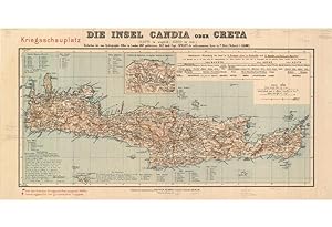
CRETAN STATE: DIE INSEL CANDIA ODER CRETA : (KRITI IM NEUGRIECH., KIRID IM T▄RK.) ; KRIEGSSCHAUPLATZ ; REDUCTION DER VOM HYDROGRAPHIC OFFICE IN LONDON 1862 PUBLICIRTEN, 1852 DURCH SPRATT AUFGENOMMENEN KARTE IN 2 BLATT (IN MASSSTAB 1:146.00
Verlag: Lithography in colour (Very Good, softvertical fold, old pencil annotations in white margins) 25 x 54 cm.
Anbieter: Antiquariat Dasa Pahor GbR, M³nchen, Deutschland
Bewertung:

Karte
Berlin: Dietrich Reimer (Ernst Vohsen) [1897]. An uncommon separately published map of the island of Crete, shows the theatre of war of 1897, which lead to the establishment of the Cretan state a year later. - This detailed separately published map of Crete shows the theatre of war of 1897. The ports marked with a red flag are sieged by the Greeks and the ports marked with a round red flag by foreign armies. In 1897, the year this map was made, the Ottoman Empire declared war on Greece, which led the Great Powers, being Britain, France, Italy, Austria-Hungary and Russia, to intervene and declare war on the Ottoman Empire. The island of Crete, an Ottoman possession since the end of the Cretan War, became a theater of war between the countries, until it was pronounced the State of Crete a year later. It was annexed to the Kingdom of Greece in 1913. The draft of the map is based upon a two sheet map of Crete by an English hydrographer, geologist and vice-admiral Thomas Abel Brimage Spratt (1881-1888), We could only trace four examples in libraries worldwide. References: OCLC: 928154853. Library of Congress. Map Division., A list of atlases and maps applicable to the world war; comp. under the direction of Philip Lee Phillips, chief, Division of maps, 1918, p. 133; Lothar Z÷gner, Antike Welten, neue Regionen: Heinrich Kiepert, 1818-1899, 1999, p. 103, no. 260.