Gesamtpreis (1 Artikel Artikel):
Versandziel:

teesdale henry (29 Ergebnisse)
Produktart
- Alle Product Types
- Bücher (13)
- Magazine & Zeitschriften
- Comics
- Noten
- Kunst, Grafik & Poster
- Fotografien
- Karten (16)
- Manuskripte & Papierantiquitäten
Zustand
Einband
Weitere Eigenschaften
- Erstausgabe
- Signiert
- Schutzumschlag
- Angebotsfoto (28)
Gratisversand
- Versand nach USA gratis
Land des Verkäufers
Verkäuferbewertung
-

Narrative of the Defence of Kars, historical and military. From Documents and Notes taken by the several Officers serving on the Staff of Her Majesty s Commissioner with the Ottoman Army in Asia Minor. Lieut. Col. C. Teesdale C.B., and W. Simpson.
Verlag: British Library, Historical Print Editions, 2011
ISBN 10: 124143428XISBN 13: 9781241434281
Buch
Zustand: New.
-

Derbyshire.
Erscheinungsdatum: 1835
Anbieter: Henry Sotheran Ltd, London, Vereinigtes Königreich
Verbandsmitglied: ABA ILAB PBFA
Bewertung:

Original steel engraved map with original hand colouring. Published in Teesdale's New British Atlas. 1835. 413 x 340 mm. Three horizontal folds, with a small spot to the top of the map and two tears to the head and tail of the right margin, just affecting the engraved border of the map, both have been professionaly repaired, nonetheless an attractive map.
-
ORIGINAL ENGRAVED MAP OF DORSET From: New British Atlas. Antique Hand Coloured.
Verlag: Teesdale & co. Holborn. ca.1830, 1830
Anbieter: PROCTOR / THE ANTIQUE MAP & BOOKSHOP, DORCHESTER, Vereinigtes Königreich
Verbandsmitglied: PBFA
Bewertung:

Karte
(Printed area approx 17x14 inches.) Un-mounted. In very good condition. Crease to centre shows originality.
-

Herefordshire.
Verlag: London:, 1831
Anbieter: Robert Frew Ltd. ABA ILAB, London, Vereinigtes Königreich
Verbandsmitglied: ABA ILAB PBFA
Bewertung:
Karte
41 x 34 cm. Original block colour. Double page map. Very good condition.
-

Leicestershire.
Verlag: London:, 1831
Anbieter: Robert Frew Ltd. ABA ILAB, London, Vereinigtes Königreich
Verbandsmitglied: ABA ILAB PBFA
Bewertung:
Karte
41 x 34 cm. Original block colour. Double page map. Very good condition.
-
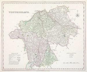
Westmorland.
Verlag: London:, 1831
Anbieter: Robert Frew Ltd. ABA ILAB, London, Vereinigtes Königreich
Verbandsmitglied: ABA ILAB PBFA
Bewertung:
Karte
34.2 x 41.5 cm. Original block colour. Double page map. Very good condition.
-

Cambridgeshire.
Verlag: London:, 1831
Anbieter: Robert Frew Ltd. ABA ILAB, London, Vereinigtes Königreich
Verbandsmitglied: ABA ILAB PBFA
Bewertung:
Karte
41 x 34 cm. Full original colour. Single page engraved map. Very good condition.
-

Monmouthshire.
Verlag: London: c1830-42, 1830
Anbieter: Peter Harrington. ABA/ ILAB., London, Vereinigtes Königreich
Verbandsmitglied: ABA ILAB PBFA
Bewertung:
A large and impressive county map by Henry Teesdale, published in his popular 'New British Atlas' - an atlas that was reissued a number of times. Map features include a compass rose, an explanation table, hundreds reference and coach roads are highlighted. Size: 465 x 370 mm. Copperplate engraving in full wash colour. Slightly toned and with a little offsettng, but in good condition.
-

Worcestershire.
Verlag: London. 1829-35, 1829
Anbieter: Peter Harrington. ABA/ ILAB., London, Vereinigtes Königreich
Verbandsmitglied: ABA ILAB PBFA
Bewertung:
Teesdale was a publisher and a founder member of the Royal Geographical Society. Between 1829 &1835 he published the "New British Atlas", and from it, this is his attractive map of Worcestershire. The map has depth and detail, and comes with helpful explanatory notes. Size: 370 x 460 mm. Copperplate engraving with original wash colour. Good condition. Some offsetting.
-

Spain & Portugal.
Verlag: London: 1831, 1831
Anbieter: Peter Harrington. ABA/ ILAB., London, Vereinigtes Königreich
Verbandsmitglied: ABA ILAB PBFA
Bewertung:
A beautiful and nicely detailed map of Spain and Portugal, in wonderful 'soft' wash colour, engraved by John Dower and published by Henry Teesdale's in 'A New General Atlas of the World'. Each region is coloured separately, and the border consists of a Greek key design. Size: 370 x 475 mm. Copperplate engraving with original wash colour. Good condition.
-

Leicestershire.
Verlag: London:, 1829
Anbieter: Robert Frew Ltd. ABA ILAB, London, Vereinigtes Königreich
Verbandsmitglied: ABA ILAB PBFA
Bewertung:
Karte
34 x 41 cm. Full original colour. Single page engraved map. Very good condition.
-

Monmouthshire
Verlag: London:, 1829
Anbieter: Robert Frew Ltd. ABA ILAB, London, Vereinigtes Königreich
Verbandsmitglied: ABA ILAB PBFA
Bewertung:
Karte
41.5 x 34 cm. Full original colour. Single page engraved map. Small tear to lower right corner, just affecting the border and with some loss to margin, otherwise in good condition.
-

Herefordshire.
Verlag: London:, 1829
Anbieter: Robert Frew Ltd. ABA ILAB, London, Vereinigtes Königreich
Verbandsmitglied: ABA ILAB PBFA
Bewertung:
Karte
41.5 x 34 cm. Full original colour. Single page engraved map. Very good condition.
-

Bedfordshire.
Verlag: London:, 1829
Anbieter: Robert Frew Ltd. ABA ILAB, London, Vereinigtes Königreich
Verbandsmitglied: ABA ILAB PBFA
Bewertung:
Karte
41.5 x 34 cm. Full original colour. Single page engraved map. Very good condition.
-

Northampton.
Verlag: London:, 1829
Anbieter: Robert Frew Ltd. ABA ILAB, London, Vereinigtes Königreich
Verbandsmitglied: ABA ILAB PBFA
Bewertung:
Karte
34 x 41.5 cm. Full original colour. Single page engraved map. Very good condition.
-

(Untitled) West Riding of Yorkshire.
Verlag: London: c1835, 1835
Anbieter: Peter Harrington. ABA/ ILAB., London, Vereinigtes Königreich
Verbandsmitglied: ABA ILAB PBFA
Bewertung:
A detailed map of the West Riding of Yorkshire, complete with explanation table. Each Wapontack is separately coloured, principal cities are highlighted, railways and all major roads are shown. Published in Henry Teesdale's Improved Edition of the New British Atlas. Size: 370 x 460 mm. Copperplate engraving in original hand colour. Some minor staining to the upper right corner, old rubbed pencil markings affecting the engraved surface, otherwise in good condition.
-

The World on Mercators Projection
Verlag: London, 1839
Anbieter: Antipodean Books, Maps & Prints, ABAA, Garrison, NY, USA
Verbandsmitglied: ABAA ANZAAB ESA ILAB
Bewertung:
A steel engraving of the world, with original outline color. From the Edinburgh Cabinet Atlas of 1839. Showing Australia divided in half, with New Holland to the west and New South Wales to the east; and Tasmania as Van Diemens Land. With just a small coastline for the Antarctic continent, showing Palmers Land and 'Grahams Land 1832'. With Greenland attached to a mythical northern land and the Northwest Passage shown up to and including Melville Island. At the lower right: "Drawn & Engraved by J. Dower, Pentonville, London" At the center below the border: "London. Published by Henry Teesdale & Co. 302 High Holborn". On watermarked paper "J. Whatman 1838". With a center fold. Slightly toned at lower right corner, otherwise very good. Image size: 16 1/8 x 13 1/8". Paper size: 18 x 14 1/2".
-
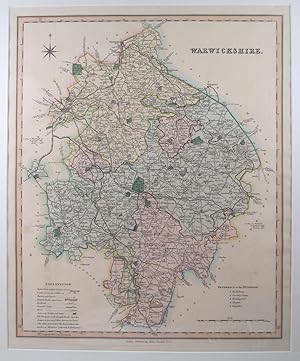
Warwickshire.
Verlag: London:, 1829
Anbieter: Robert Frew Ltd. ABA ILAB, London, Vereinigtes Königreich
Verbandsmitglied: ABA ILAB PBFA
Bewertung:
Karte
41.5 x 34 cm. Full original colour. Single page engraved map. Very good condition.
-

Cambridgeshire.
Verlag: London:, 1829
Anbieter: Robert Frew Ltd. ABA ILAB, London, Vereinigtes Königreich
Verbandsmitglied: ABA ILAB PBFA
Bewertung:
Karte
41 x 34 cm. Full original colour. Single page engraved map. Very good condition.
-

South Wales.
Verlag: London:, 1829
Anbieter: Robert Frew Ltd. ABA ILAB, London, Vereinigtes Königreich
Verbandsmitglied: ABA ILAB PBFA
Bewertung:
Karte
34 x 41.5 cm. Full original colour. Single page engraved map. Very good condition.
-

OXFORDSHIRE
Verlag: Improved Edition of the New British Atlas. Henry Teesdale & Co. 1835., 1835
Anbieter: Peter Harrington. ABA/ ILAB., London, Vereinigtes Königreich
Verbandsmitglied: ABA ILAB PBFA
Bewertung:
A detailed map of Oxfordshire in full original colour. Reference to the Hundreds, Scale and Key. Copper engraving. Original colour. Very good condition. Size: 34 x 41.5 cm. (13˝ x 16˝ inches).
-
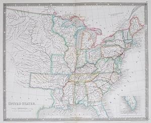
United States.
Verlag: London Henry Teesdale & Co., 1844
Anbieter: Robert Frew Ltd. ABA ILAB, London, Vereinigtes Königreich
Verbandsmitglied: ABA ILAB PBFA
Bewertung:
Karte
(47.5 x 38.5 cm). Original engraved map of the United States with original hand-colouring. Some light soiling to upper margin. Generally very good.
-

Cambridgeshire.
Verlag: London: Henry Teesdale, c. 1835, 1835
Anbieter: Peter Harrington. ABA/ ILAB., London, Vereinigtes Königreich
Verbandsmitglied: ABA ILAB PBFA
Bewertung:
A detailed map Cambridgeshire, complete with explanation table. Each area is separately coloured, principal cities are highlighted, railways and all major roads are shown. Published in Henry Teesdale's Improved Edition of the New British Atlas. Copperplate engraving in original hand colour. Sheet size: 46.5 x 37 cm. Image size: 41 x 34 cm Very good condition, centrefold as issued.
-
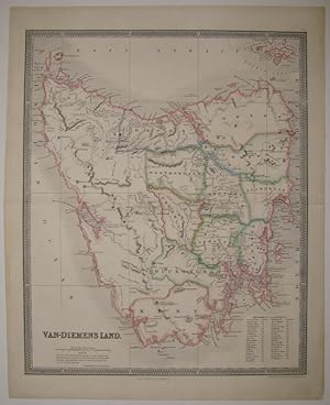
Van-Diemens Land
Verlag: Henry Teesdale & Co, London
Anbieter: Argosy Book Store, ABAA, ILAB, New York, NY, USA
Bewertung:
Zustand: very good(+). John Dower (illustrator). Map. Engraving with original hand outline color. Image measures 16.25" x 13.25". Beautiful clear double page map of Tasmania divided into counties, circa 1835. Notes extensive geographical features. Topographical elements indicated with hachure marks. A table indicates the original 37 districts. Van Diemen's Land was the original name used by most Europeans for the island of Tasmania, now part of Australia. The name was changed from Van Diemen's Land to Tasmania in 1856. It was first named after Dutch explorer Abel Tasman. Engraved by John Dower and published in Teesdale's "New General Atlas of the World". Small tear to right edge, repair to centerfold.
-

Ireland.
Verlag: London:, 1829
Anbieter: Robert Frew Ltd. ABA ILAB, London, Vereinigtes Königreich
Verbandsmitglied: ABA ILAB PBFA
Bewertung:
Karte
64 x 51.5 cm. Full original colour. Large folding page map of Ireland. A few minor stains scattered across sheet. Some occasional light offsetting, otherwise in good condition.
-

Persia and Arabia.
Verlag: London, 1847., 1847
Anbieter: Antiquariat INLIBRIS Gilhofer Nfg. GmbH, Vienna, A, Österreich
Verbandsmitglied: ILAB VDA VDAO
Bewertung:
Engraved map (41 x 33 cm), hand-coloured in outline. - Al-Qasimi 243.
-
Yorkshire To the Nobility, Gentry & Clergy of Yorkshire this Map of the County constructed from a survey commenced in the year 1817 & corrected in the years 1827 & 1828, is respectfully dedicated by the proprietors.
Verlag: LondonHenry Teesdale and Co. and C. Stocking Paternoster Row. April 21. ., 1828
Anbieter: Robert Frew Ltd. ABA ILAB, London, Vereinigtes Königreich
Verbandsmitglied: ABA ILAB PBFA
Bewertung:
Karte
Very large folding map of the county printed over three equal parts. Overall c. 184 x 220 cm,Each part dissected into 24 sections and mounted on linen, the parts fold into original calf slipcase, red label. The map with full original colour, large vignette view of York Minster to lower right corner.
-
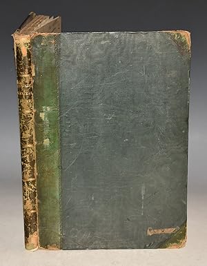
A Travelling Atlas : Containing a Complete Set of County Maps, on Which are Delineated all the Mail & Turnpike Roads, The Cities, Towns .
Verlag: Henry Teesdale & Co. 1843, London, 1843
Anbieter: Foster Books - Stephen Foster - ABA, ILAB, & PBFA, London, Vereinigtes Königreich
Verbandsmitglied: ABA ILAB PBFA
Bewertung:
Full Leather. Zustand: Very Good. (iii), + 45 plates, pp. Contemporary decoratively embossed black leather with gilt title panel to front board. New black morocco spine. All edges gilt. Slight wear to corners and board edges. Early ownership stamp to front pastedown & endpaper. Early ink name to rear free endpaper. Engraved title-page with vignette. With forty-five full-page colour maps, including one folding. Plates complete. A few minor light stains to some plates. The maps show roads and railways. OCLC records just Cambridge for this edition, with copies of the 1830 edition in the BL, Cambs & Newberry Library, Chicago. Very scarce. This atlas appears to have been a commercial failure. Perhaps because it followed Teesdale's successful 'New British Atlas', published only the year before. This later edition emphasises the roads and the newly emerging railway network. Small 4to.
-
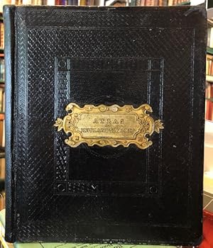
A New General Atlas of The World, Compiled from the best authorities both English & Foreign, containing separate Maps of its various Countries & States, and exhibiting their Boundaries & Divisions, also the chains of Mountains, Rivers, Lakes and other Geographical Features. Comprehended in Forty-Seven Maps, including Ancient Maps of Greece, the Roman & Persian Empires & Palestine, from drawings made expressly for this work, by John Dower.
Verlag: London, Henry Teesdale & Co., 1836 1st, 1836
Anbieter: PROCTOR / THE ANTIQUE MAP & BOOKSHOP, DORCHESTER, Vereinigtes Königreich
Verbandsmitglied: PBFA
Bewertung:
Large Hardback, approx 15 x 10 inches. Halfbound in dark green calf leather and dark green silk cloth to boards. Gilt lettering and banding to spine. Brown endpapers. In very good condition. Ends of spine and corners bumped and chipped, spine rubbed. Some rubbing and marks to boards. Small binders label to corner of front endpaper ?J. Martin & Son.? Some darkening to back sides of endpapers, neat inscription to verso of title plate. Some minor handling/thumb marks to edges of plates, else plates all very clean and bright throughout. Else a very good clean and tight copy. Illustrated with 47 hand-coloured double-page engraved map plates (India plate is larger, fold-out) PLUS engraved double-page title plate with vignette.