
Gesamtpreis (1 Artikel Artikel):
Versandziel:

stanfords geographical establishment (6 Ergebnisse)
Direkt zu den wichtigsten Suchergebnissen
Suchfilter
Produktart
- Alle Product Types
- Bücher (1)
- Magazine & Zeitschriften (Keine weiteren Ergebnisse entsprechen dieser Verfeinerung)
- Comics (Keine weiteren Ergebnisse entsprechen dieser Verfeinerung)
- Noten (Keine weiteren Ergebnisse entsprechen dieser Verfeinerung)
- Kunst, Grafik & Poster (Keine weiteren Ergebnisse entsprechen dieser Verfeinerung)
- Fotografien (Keine weiteren Ergebnisse entsprechen dieser Verfeinerung)
- Karten (5)
- Manuskripte & Papierantiquitäten (Keine weiteren Ergebnisse entsprechen dieser Verfeinerung)
Zustand Mehr dazu
- Neu (Keine weiteren Ergebnisse entsprechen dieser Verfeinerung)
- Wie Neu, Sehr Gut oder Gut Bis Sehr Gut (2)
- Gut oder Befriedigend (3)
- Ausreichend oder Schlecht (1)
- Wie beschrieben (Keine weiteren Ergebnisse entsprechen dieser Verfeinerung)
Einband
- alle Einbände
- Hardcover (2)
- Softcover (Keine weiteren Ergebnisse entsprechen dieser Verfeinerung)
Weitere Eigenschaften
- Erstausgabe (Keine weiteren Ergebnisse entsprechen dieser Verfeinerung)
- Signiert (Keine weiteren Ergebnisse entsprechen dieser Verfeinerung)
- Schutzumschlag (Keine weiteren Ergebnisse entsprechen dieser Verfeinerung)
- Angebotsfoto (6)
Sprache (2)
Gratisversand
- Kostenloser Versand nach USA (Keine weiteren Ergebnisse entsprechen dieser Verfeinerung)
Land des Verkäufers
Verkäuferbewertung
-
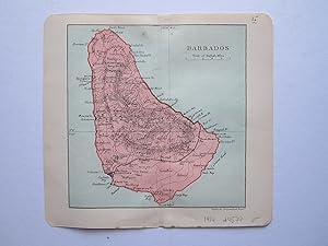
Barbados
Verlag: Duckworth & Co. London, 1914
Anbieter: Angelika C. J. Friebe Ltd. - MapWoman, Dorking, Vereinigtes Königreich
Verkäuferbewertung 4 von 5 Sternen

Karte
EUR 17,74
EUR 22,96 Versand
Versand von Vereinigtes Königreich nach USAAnzahl: 1 verfügbar
In den WarenkorbNo Binding. Zustand: Near Fine. colour printed map; overll 17 x 18 cm. fold as issued; exc. cond. A very attractive map of Barbados from Stanford's "The Pocket Guide to The West Indies"; edited by Algeron E. Aspinall; 3rd edition.
-
Stanford's War Maps No.5 - The North Sea (also titled Map of the North Sea)
Sprache: Englisch
Verlag: Edward Stanford, London, 1914
Anbieter: Dendera, London, Vereinigtes Königreich
Verkäuferbewertung 5 von 5 Sternen

Karte
EUR 206,97
EUR 28,71 Versand
Versand von Vereinigtes Königreich nach USAAnzahl: 1 verfügbar
In den WarenkorbHardcover. Zustand: Good. Colour map 73 x 56cm, dissected in 18 sections and mounted on linen, folding into the original red cloth case 13 x 19cm with Stanford's title label to the front, and adverts inside. Map good, tanned with cloth bleeding and damp staining to verso. Case acceptable only, heavily damp stained, though structurally sound. Dated 12 August 1914, 8 days after Britain declared war on Germany. It covers the British Isles, Faroe Islands, Benelux, Denmark, most of Germany, Southern Scandinavia and parts of France, Russia & Austria-Hungary on a scale of 50.8235 miles to 1 inch or 1:3,220,177. This map was updated as the war progressed. Rare - 10 copies of all editions on Worldcat and Jisc (20 Aug 1914, 1916, 1917).
-
Stanford's Popular Map of the Seat of War in the East, including Turkey in Europe and Asia, Greece, the Black Sea, the Adjacent Parts of Austria, Russia &c; Egypt, Cairo, and Suez on the South; the Caspian Sea on the East; and Venice, Rome, and Malta on the West
Verlag: Edward Stanford, London, 1877
Anbieter: Dendera, London, Vereinigtes Königreich
Verkäuferbewertung 5 von 5 Sternen
Karte
EUR 413,94
EUR 28,71 Versand
Versand von Vereinigtes Königreich nach USAAnzahl: 1 verfügbar
In den WarenkorbHardcover. Zustand: Very Good. The long title is from the front panel. The map itself is simply titled "Stanford's Popular Map of the Seat of War". Colour folding map 68 x 50cm dissected in 18 sections mounted on linen, folding into the original red cloth case 12 x 18cm with Stanford's printed label to the front and advert for Stanford's Series of New Library Maps to inner panels. Map very good, tanned with some spotting, creased to the lower right corner. Case good, marked, with partial splits and minor loss to spine cloth. Undated, c1877, dating to the Russo-Turkish War of 1877-78, which weakened and diminished the Ottoman Empire. Scale approx 1:5,000,000. Features include railways, submarine telegraph lines, and relief shown by hachures. Scarce.
-
Map ] The Pacific War Zone with Routes and Distances
Verlag: Edward Stanford, London, 1944
Anbieter: Dendera, London, Vereinigtes Königreich
Verkäuferbewertung 5 von 5 Sternen
Karte
EUR 177,40
EUR 28,71 Versand
Versand von Vereinigtes Königreich nach USAAnzahl: 1 verfügbar
In den WarenkorbNo Binding. Zustand: Fair. Colour folding map 115 x 88cm. The map itself is undated, but Oct 18, 1944 is pencilled to the lower margin. Fair only, with wear and closed tears to edges, pinholes to corners, small holes at intersections, minor loss, label residue to top edge, and ink spots lower right. Colours bright. A sliding scale is given in miles for the Equator and respective parallels, with Hawaii close to the centre. Features include main railways and steamship routes with distances in nautical miles. Rare, with Worldcat and Jisc showing more than one copy each at the British Library, Oxford, and National Library of Scotland, and Worldcat showing one each at the Universities of Amsterdam and Michigan (dates estimated 1942, 1944, and 1945).
-
Large Scale Map of the Nile from Dongola to Khartum. Scale 16 miles to 1 inch. Maße Karte ca. 57.5 x 73 cm.
Verlag: Published by Edward Stanford, London, 1884, 1884
Zustand: good. Landkarte. Sofortversand aus Deutschland. Artikel wiegt maximal 500g. 1 Seiten. Karte mit Beschädigungen, Verfärbungen. Rückseite mit Beschriftung. Vorderseite mit kl. Stempel.
-

JAPAN (London, Edward Stanford, Stanford's Grographical Establishment)
Erscheinungsdatum: 1887
Karte
No Binding. Zustand: As New. Detailed map of Japan, from Stanford's London Atlas. 47.4 x 60cm.


![Bild des Verkäufers für Map ] The Pacific War Zone with Routes and Distances zum Verkauf von Dendera](https://pictures.abebooks.com/inventory/md/md30961911285.jpg)
