
Gesamtpreis (1 Artikel Artikel):
Versandziel:

spitzbergen (19 Ergebnisse)
Direkt zu den wichtigsten Suchergebnissen
Suchfilter
Produktart
- Alle Product Types
- Bücher (14)
- Magazine & Zeitschriften (Keine weiteren Ergebnisse entsprechen dieser Verfeinerung)
- Comics (Keine weiteren Ergebnisse entsprechen dieser Verfeinerung)
- Noten (Keine weiteren Ergebnisse entsprechen dieser Verfeinerung)
- Kunst, Grafik & Poster (1)
- Fotografien (Keine weiteren Ergebnisse entsprechen dieser Verfeinerung)
- Karten (4)
- Manuskripte & Papierantiquitäten (Keine weiteren Ergebnisse entsprechen dieser Verfeinerung)
Zustand Mehr dazu
- Neu (Keine weiteren Ergebnisse entsprechen dieser Verfeinerung)
- Wie Neu, Sehr Gut oder Gut Bis Sehr Gut (Keine weiteren Ergebnisse entsprechen dieser Verfeinerung)
- Gut oder Befriedigend (2)
- Ausreichend oder Schlecht (Keine weiteren Ergebnisse entsprechen dieser Verfeinerung)
- Wie beschrieben (17)
Einband
Weitere Eigenschaften
- Erstausgabe (5)
- Signiert (1)
- Schutzumschlag (Keine weiteren Ergebnisse entsprechen dieser Verfeinerung)
- Angebotsfoto (9)
Sprache (3)
Gratisversand
Land des Verkäufers
Verkäuferbewertung
-

Spitzbergen. Eine landeskundliche Studie. - Ergänzungsheft Nr. 211 zu: Petermanns Mitteilungen.
Verlag: Gotha, Justus Perthes, 1931., 1931
Anbieter: Antiquariat Carl Wegner, Berlin, B, Deutschland
Verbandsmitglied: GIAQ
Verkäuferbewertung 5 von 5 Sternen

Erstausgabe
Softcover. 27,5 x 19 cm. Originalbroschur, der Einband ist etwas randlädiert. 109 Seiten mit Abbildungen im Anhang auf den Tafeln 1 - 8, teilweise ausfaltbar. Innen sauber. Insgesamt guter Zustand. -- Bitte Portokosten außerhalb EU erfragen! / Please ask for postage costs outside EU! / S ' il vous plait demander des frais de port en dehors de l ' UE! // Bitte beachten Sie auch unsere Fotos! / Please also note our photos! / Veuillez noter nos photos -- Freuen Sie sich mit uns auf den Frühlingsanfang und lesen Sie einen Liebesroman aus unserer Schmonzettenecke! -- Wir kaufen Ihre werthaltigen Bücher! K00946-413809.
-

Weltgeschehen am Rande des Polarmeeres. Spitzbergen in der Weltpolitik.
Verlag: Würzburg, Marienburg-Verlag., 1964
Anbieter: ANTIQUARIAT MATTHIAS LOIDL, Unterreit-Stadl, Deutschland
Verkäuferbewertung 5 von 5 Sternen
Gr.-8°. 204 S., OLwd. mit (etw. verblaßtem) OUmschl. EA.
-
BIRD PRINT, LACOPUS HYPERBOREUS , LASSEN BAY, SPITZBERGEN, BY TREVOR BATTYE, FIRST PROOF, ORNITHOLOGY PRINT
Sprache: Englisch
Erscheinungsdatum: 1968
Anbieter: K Books Ltd ABA ILAB, York, YORKS, Vereinigtes Königreich
Verbandsmitglied: ABA ILAB PBFA
Verkäuferbewertung 5 von 5 Sternen
Erstausgabe
EUR 23,69
EUR 22,54 Versand
Versand von Vereinigtes Königreich nach USAAnzahl: 1 verfügbar
In den WarenkorbSingle Sheet Engraving. Zustand: Very Good. No Jacket. TREVOR BATTYE (illustrator). First Edition. BIRD PRINT, LACOPUS HYPERBOREUS , LASSEN BAY, SPITZBERGEN, BY TREVOR BATTYE, FIRST PROOF, ORNITHOLOGY PRINT. BEAUTIFULLY COLOURED, SNOW SCENE AND MOUNTAINS IN BACKGROUND CIRCA 1968, TOO LARGE TO MOUNT SO DISPATCHED FOLDED IN A STRONG TUBE.
-
Spitzberg. Norddeutscher Lloyd Bremen .
Verlag: Bremen ca, 1910
Anbieter: Antiquariat Hartmut R. Schreyer, Augsburg, Deutschland
Verkäuferbewertung 5 von 5 Sternen
6 Bll. (le.we.) mit 7 teils doppelblattgr. Fotoabb. (davon 3 farbig). 30 x 24,5 cm. Illustr.Orig.-Kart. Text französisch. - Werbeheft des Norddeutschen Lloyd mit Informationen zu Spitzbergen. - (gut erhalten).
-
Projet de mesure d un arc du méridien de 4° 20 au Spitzberg. Mémoire publié par l Académie Royale des Sciences de Sučde.
Verlag: Stockholm, Norstedt & Söner, 1893., 1893
Anbieter: Antiquariat MEINDL & SULZMANN OG, Wien - Vienna, Österreich
Verkäuferbewertung 4 von 5 Sternen

Gr.-8°. Mit 1 mehrf. gef., farb. Karte. 31 SS. Hln. d. Zt. mit goldgepr. Rtitel (guter Erhaltungszustand, Innendeckel mit Bibl.-Schildchen, Titel mit Bibl.-Stempel).
-
Spitzbergen . Mit 180 Zeichnungen, Karten und Diagrammen vom Verfasser.
Verlag: Leipzig : Brockhaus,, 1922
Anbieter: Antiquariat Hartmut R. Schreyer, Augsburg, Deutschland
Verkäuferbewertung 5 von 5 Sternen
327 S. Gr-8°. Illustr.Orig.-Leinen. 2. Aufl. - (Name auf Titelbild verso, sonst gut erhalten).
-
Spitzbergens Natur und Geschichte. Mit einer Einführung von Geh. Reg.-Rat Prof. Dr. H. Hergesell. Autorisierte deutsche Ausgabe. Mit zahlreichen Illustrationen und Karten und einem Führer für Spitzbergen-Touristen. Autorisierte deutsche Ausgabe.
Verlag: Berlin, Verlag Nordland., 1912
Anbieter: Antiquariat Rainer Schlicht, Berlin, Deutschland
Verbandsmitglied: GIAQ ILAB VDA
Verkäuferbewertung 5 von 5 Sternen
1.-3. Tausend. Ca. 22,5 x 14,5 cm. 125 (1) Seiten, mit Abbildungen und Karten. Illustrierter Original-Leinenband. Seltener Spitzbergen-Führer. Einband leicht fleckig, erste und letzte Seiten leicht stockfleckig. Schönes Exemplar.
-
Tre mĺnaders dag, minnen frĺn Svenska Spetsbergs-Expeditionen 1890. Stockholm 1891.
Verlag: 1891, 1891
Anbieter: Charlotte Du Rietz Rare Books (ILAB), Stockholm, Schweden
Verkäuferbewertung 5 von 5 Sternen
Erstausgabe
12mo. Pp. (xii), 176. With frontispiece, 7 full page plates and 7 illustrations in the text. Original pictorial boards, spine restored, some staining to covers. Bookplate and old ownership signature. Scarce first edition of this charming travelogue by the expedition's zoologist. The Swedish expedition to Spitzbergen during the summer of 1890 was headed by Gustaf Nordenskiöld. The aim of the mission was to investigate geological and zoological conditions at Spitzbergen. Hulth 100. Ragnar Thorén, Svenska Arktiska expeditioner under 1800-talet, pp. 187-206.
-
Zoologische Ergebnisse der Schwedischen Expedition nach Spitzbergen 1908 unter Leitung von Prof. De Geer. Theil II. (Kungl. Svenska Vetenskapsakademiens Handlingar. Band 54). Stockholm 1915-1918.
Verlag: 1915, 1915
Anbieter: Charlotte Du Rietz Rare Books (ILAB), Stockholm, Schweden
Verkäuferbewertung 5 von 5 Sternen
4to. Original boards. This volume; (part 54 of the "Proceedings of the Royal Swedish Academy") is complete with 10 different zoological works. Comprises:1. ODHNER, N.HJ.: Die Molluskenfauna des Eisfjordes. With 13 plates; 2. VON HOFSTEN, N.: Die Echinodermen des Eisfjords. With two plates; 3. HENTSCHEL, E.: Die Spongien des Eisfjords; 4. JÄDERHOLM, E.: Die Hydroiden des Eisfjords; 5. APPELLÖF, A.: DIe Pyenogoniden des Eisfjords. With one plate; 6. BJÖRCK, W.: Die Schizopoden des Eisfjords; 7. VON HOFSTEN, N.: Die Decapoden Crustaceen des Eisfjords. With two plates; 8. OLDEVIG, H.: Die Amphipoden, Isopoden und Cumaceen des Eisfjords; 9. MOLANDER, A.R.: Die Alcyonaceen des Eisfjords; 10. VON HOFSTEN, N.: Die Fische des Eisfjords.This was De Geer's last and also his largest expedition to Spizbergen. The purpose of the expedition was to continue the cartographic work of the Isfjorden region and to further investigate the charcteristic polar-sea environment in detail with various studies of the physical geography and the marine zoology, etc. Liljequist, High Latitudes, pp. 323-326.
-
Nouvelles Observations sur le District volcanique du Spitsberg du Nord.
Anbieter: Herman H. J. Lynge & Sřn ILAB-ABF, Copenhagen, Dänemark
Verkäuferbewertung 5 von 5 Sternen
Kristiania, Dybwad, 1914. Lex8vo. Contemp. hcloth. Gilt lettering. (4),33 pp., 13 photographic plates and 4 folded maps. (Videnskapsselskapets Skrifter. I. math.-naturv. Klasse. 1914. No.9).
-

ADOLF MIETHE (1862-1927 nach Zugunglück) deutscher Photochemiker und Pionier der Fototechnik. 1910 nahm er an der Studienexpedition des Grafen Zeppelin nach Spitzbergen teil, die die Möglichkeit erkundete, die Polargebiete mit einem Luftschiff zu erforschen, und dazu meteorologische Untersuchungen vornahm. 1914 leitete er eine Expedition nach Sandnessjřen in Norwegen zur Beobachtung der Sonnenfinsternis vom 21. August; Geheimer Regierungsrat. Seit 1960 ist er Namensgeber für den Miethe-Gletscher in der Antarktis.
Anbieter: Herbst-Auktionen, Detmold, Deutschland
Verkäuferbewertung 3 von 5 Sternen

Erstausgabe Signiert
SPITZBERGEN Das Alpenland im Eismeer, Sommerfahrten und Wanderungen von A. Miethe. (Großer Text-Fotobildband) Verlag Dietrich Reimer (Ernst Vohsen) Berlin, 1. Auflage 1925, ERSTAUSGABE, 264 SS. gebunden (Hardcover Oln. kl. 4°, Einband mit Gebrauchsspuren), ordentlich erhalten, Innendeckel mit EX LIBRIS des Widmungsempfängers - Titelseite mit eigenhändiger Widmung, Empfehlung, Ort, Datum, Unterschrift in Tinte signiert "Herrn Expeditionschef Zimmer mit besten Empfehlungen MIRETHE Charlottenburg 4/5/26" ZUSÄTZLICH auf vorderen Innendeckel montiert . Brief (1 S. 4° mit gedrucktem persönlichen Briefkopf) mit Ort, Datum, eigenhändiger Unterschrift in Tinte signiert Charlottenburg, 28. Juni 25 - an denselben, Expeditionschef Zimmer, Forsvars-Ministeriet Oslo über sein Spitzbergen-Projekt und mit baldiger Besuchs-Ankündigung in Oslo. - SEHR SELTEN !
-
Nogle Bidrag til de nordlige Landes Geografi og Naturhistorie, sammenstillede efter Iagttagelser, gjorte paa den norske Nordhavs-Expedition 1876-78. Med 6 farvetrykte Billeder og 9 Trćsnit samt 2 Karter. - Contributions to the Geography and Natural Hi.
Anbieter: Herman H. J. Lynge & Sřn ILAB-ABF, Copenhagen, Dänemark
Verkäuferbewertung 5 von 5 Sternen
(Christiania (Oslo), Grřndahl & Sřn, 1882). Folio. (36 x 28 cm.). Samtidigt hshirtbd. Kapitćler reparerede. 36 pp. med dobbeltspaltet tekst (dansk of engelsk) og trćsnit i teksten samt 6 pragtfulde kromolitograferede plancher tegnet af F.W. Schiertz, litograferet af F. Larsen, Hoffenberg & Trap, 2 litograferede kort. Udsnit (eller sćrtryk) af "Den Norske Nordhavs-Expedition 1876-1878. The Norwegian North-Atlantic Expedition 1876-1878". De 6 farvelitografier er i perfekt stand: 1. Fra Vestmanna-Öerne. Island. - 2. Lagunen paa Östsiden af Jan Mayen. - 3. Beerenberg. Jan Mayen. - 4. Östsiden af Beeren-Eiland. - 5. Sydkap. Spidsbergen. - 6. Magdalene-Bai. Spidsbergen. - Kortene: 1. Kaart over Jan Mayen udarbejdet af C. Wille og H. Mohn. - 2. Kart over Advent Bay. Optaget af C.F. Wille.
-
Voyage au Pole Boréal, fait en 1773, par Ordre du Roi D'Angleterre. Traduit de L'Anglois.
Anbieter: Herman H. J. Lynge & Sřn ILAB-ABF, Copenhagen, Dänemark
Verkäuferbewertung 5 von 5 Sternen
Erstausgabe
Paris, Saillant & Nyon (et) Pissot, 1775. 4to. Contemp. full calf. Raised bands, richly gilt spine, titlelabel with gilt lettering. Stamps on title-page. XII,260 (incl. 2 folded tables),(4) pp., 3 folded engraved maps and 9 folded engraved plates. Internally clean, 3 plates with a faint dampstain. First French edition. "An importent addition to nautical science which does honor to its author. Besides of a journal of the voyage, it contains a descriptive catalogue of the natural productions of Spitzbergen." (Sabin). Phipps here mapped the northern part of Spitzbergen.Sabin,62574.
-
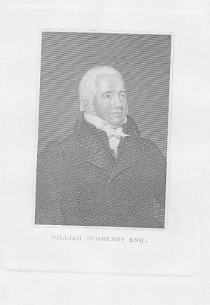
Porträt. Halbfigur, halbrechts. Stahlstich (anonym), 15,5 x 12 cm, um 1850.
Anbieter: Antiquariat Michael Eschmann, Groß-Gerau, Deutschland
Verkäuferbewertung 4 von 5 Sternen
Kunst / Grafik / Poster
0. Selten. - Schönes Blatt in guter Erhaltung. Sprache: Deutschu.
-
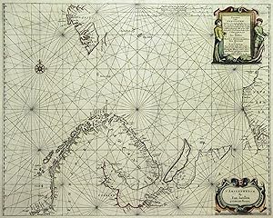
![Bild des Verkäufers für [Greneland / Wiches Lande]. zum Verkauf von Geographicus Rare Antique Maps](https://pictures.abebooks.com/inventory/md/md32068517142.jpg)
[Greneland / Wiches Lande].
Erscheinungsdatum: 1744
Anbieter: Geographicus Rare Antique Maps, Brooklyn, NY, USA
Verbandsmitglied: ABAA ESA ILAB
Verkäuferbewertung 4 von 5 Sternen
Karte
Excellent. A superb example with a bold strike. Centerfold very unobtrusive. Size 11.5 x 13 Inches. This is a scarce 1744 Church / Edge map of map of the Arctic Spitzbergen / Svalbard archipelago. The region here represented was the Europe's best whaling and walrusing ground in the 18th century. A Closer Look The mapping of the western portions of the archipelago - formerly known as Spitzbergen - is very accurate, despite being erroneously labeled 'Greneland.' In its earliest version, printed by Samuel Purchas, it was attributed to Thomas Edge, an English whaler and seal-hunter who made a number of voyages to the region, and after whom several features on the map are named. For more than a century, this was the most detailed map of the Arctic archipelago. The Map The map is untitled, and the most prominent place name is 'Greneland,' which was the English term for the islands the Dutch called Spitzbergen, here referring to Svalbard. To the west is Prince Charles' Island, now known as Foreland . The coastline of the aptly-named Nordaustlandet is confused: Edge, if indeed he composed the map, could not say whether it was another island or part of Svalbard, and he passes this bafflement on to the reader. Only the west coasts of Barents' Island and Edge Island are shown, and the passage dividing them - Freemansundet - is here referred to as Ald Fremans Inlett , suggesting that Edge suspected the two islands to be connected. At the eastern extreme lies Wiches lande , which is either a representation of an insufficiently-distant Nova Zembla, or entirely imaginary, there being no corresponding actual land mass. In his account in Purchas, Edge that an English ship 'discoverd to the eastwards of Greenland (Svalbard) as farre to the North-Wards as seventie nine degreez, and an iland which he named Witches Iland, and divers other ilands as by the map appeareth.' By the description, this might refer to the Kong Karls Land Islands, which the large coastline of the map's 'Wiches Lande' does not at all resemble. The Vignettes The eleven scenes bordering the map, also informed by Edges' voyages to the islands, depict the whaling, walrus, and bear-hunting which drew 17th century European sailors. Whaling, in particular, is shown in detail, including the means by which the whales were processed for oil and blubber. Thomas Edge and the Muscovy Company The Muscovy Company was a joint-stock company initially chartered in 1555 to exploit a monopoly of trade between England and Russia. In 1577, Queen Elizabeth I extended the Company's charter to include a monopoly on whaling. The most profitable whaling grounds in the beginning of the seventeenth century were centered around Spitsbergen. In 1611, the company gave Captain Thomas Edge command of two ships for a whaling voyage. He wrote of the journey in his A Brief Discovery of the Northern Discoveries , published posthumously Purchas His Pilgrimes where it was accompanied by the first version of the present map. The details on the map, as well as the vignettes, were not intended as generalized descriptions of whaling, walrusing, and so on, but were depictions of specific events in Edge's journeys to which he referred in his text. Later publications by the Churchill brothers accompany accounts other than Edge's, a testament to its longevity. Publication History and Census This map was printed on at least two plates; the first appeared in Samuel Purchas' 1625 Purchas His Pilrimes ; the second appeared in the fourth volume of Awnsham and John Chuchill's 1704 Collection of Voyages and Travels . A further edition of that work, printed in 1744, included this map as well, either printed from a much-reworked second or third plate. This example corresponds to the 1744 issue of the map. Churchill's Voyages and Travels , are well represented in institutional collections. Separate examples - possibly of the 1704 issue - are listed in the Danish National Library and the Royal Danish Library. References: OCLC 81600.
-
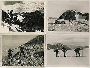
51 photographs by expedition photographer W. Ankersen.
Anbieter: Meridian Rare Books ABA PBFA, London, Vereinigtes Königreich
Verbandsmitglied: ABA ILAB PBFA
Verkäuferbewertung 5 von 5 Sternen
EUR 3.571,46
EUR 28,90 Versand
Versand von Vereinigtes Königreich nach USAAnzahl: 1 verfügbar
In den WarenkorbNo Binding. Zustand: Very Good. 51 original photographs, each approx. 88 x 115mm., all inkstamped to verso with the expedition name and the separate inkstamp of Dr. W. Ankersen, many also bearing the inkstamp of expedition leader Dr. Max Grotewahl and/or the inkstamp of the Archiv für Polarforschung, all numbered variously several times in ink or by hand, 9 of them identified by hand to verso; in very good and unfaded condition. The Deutsche Spitzbergen Expedition of 1925 was a 4-man expedition led by Max Grotewahl, with Walter Ankersen (photographer), Fritz Biller (cinematographer), and Rudolf Jupitz (geologist and biologist). The four men spent the period from mid-July to early Septetmber exploring the Magdalena Bay region in north west Spitsbergen. They crossed three new passes and ascended six peaks for the first time. The expedition travelled back from Spitsbergen aboard S.M.S. Zieten, then under the command of Alfred Ritscher. The present collection of photographs is the work of the the expedition photographer Ankersen, but seems to derive from Grotewahl's archives in Kiel. All but one, a photograph showing a map of the expedition's routes, show field images from the expedition, including high-level shots taken during their climbs, mountain views, images of the various camps, an image of the cruise ship that carried the expedition to Spitsbergen, and an image of the Zieten which brought it back. The photographs appear never to have been published.
-

'Carte Du Spits-Berg Suivant les Hollandois, Pour servir ŕ Histoire Générale des Voages. Par M.B. Ingr. de la Marine 1758.':.
Sprache: Deutsch
Anbieter: Antiquariat Norbert Haas, Bedburg-Hau, Deutschland
Verkäuferbewertung 5 von 5 Sternen
Karte
Kupferstich v. Jacques Nicolas Bellin aus A.F. Prévost d'Exiles: Histoire générale des voyages, dat. 1758, 22 x 30,5 Tooley's Dic. of Mapm. Rev. Ed. A - D, S. 116f. - Zeigt die norwegische Inselgruppe Spitzbergen im Nordatlantik und Arktischen Ozean. - Oben links Titelkartusche. Shows the Norway archipelago Spitsbergen in the Arctic Ocean and North Atlantic Ocean. - At the top left title cartouche.
-

Kupferstich- Karte, b. Jan Janssonius, "Pascaart van de Zee-Cutsen van Finmarcken, Laplant, Russland, Nova Zembla en Spitsberge .".
Sprache: Deutsch
Anbieter: Antiquariat Clemens Paulusch GmbH, Berlin, Deutschland
Verkäuferbewertung 5 von 5 Sternen
Karte
EUR 1.100,00
EUR 26,90 Versand
Versand von Deutschland nach USAAnzahl: 1 verfügbar
In den Warenkorbmit altem Grenzkolorit, um 1650, 43,6 x 55 Krogt. Koeman's Atlantes Neerlandici, Bd. 1, Seite 567 ( Abbildung 0120:1 - lat. Ausgabe mit den Seitenzahlen 111-112 = 1. Ausgabe ). - Seltene Seekarte des nördl. Teils von Norwegen und der Halbinsel Kola. Im Osten noch Nowa Zemla, im Norden mittig Spitzbergen.
-
Kupferstich- Karte, b. Jan Janssonius, "Pascaart van de Zee-Cutsen van Finmarcken, Laplant, Russland, Nova Zembla en Spitsberge .".
Sprache: Deutsch
Anbieter: Antiquariat Clemens Paulusch GmbH, Berlin, Deutschland
Verkäuferbewertung 5 von 5 Sternen
Karte
EUR 1.100,00
EUR 26,90 Versand
Versand von Deutschland nach USAAnzahl: 1 verfügbar
In den Warenkorbmit altem Grenzkolorit, 1659, 43,6 x 55 Krogt. Koeman's Atlantes Neerlandici, Bd. 1, Seite 567 ( Abbildung 0120:1 - lat. Ausgabe 1659). - Seltene Seekarte des nördl. Teils von Norwegen und der Halbinsel Kola. Im Osten noch Nowa Zemla, im Norden mittig Spitzbergen. - Restauriert.

