
Gesamtpreis (1 Artikel Artikel):
Versandziel:

shannon joseph (27 Ergebnisse)
Produktart
- Alle Product Types
- Bücher (27)
- Magazine & Zeitschriften
- Comics
- Noten
- Kunst, Grafik & Poster
- Fotografien
- Karten
- Manuskripte & Papierantiquitäten
Zustand
Einband
Weitere Eigenschaften
- Erstausgabe (1)
- Signiert
- Schutzumschlag
- Angebotsfoto (17)
Gratisversand
- Versand nach USA gratis
Land des Verkäufers
Verkäuferbewertung
-

There and Back Again : A Child of the Sixties Returns to His Catholic Roots
Verlag: Joseph Shannon, 2018
ISBN 10: 0692092064ISBN 13: 9780692092064
Buch
Zustand: Very Good. Used book that is in excellent condition. May show signs of wear or have minor defects.
Mehr Angebote von anderen Verkäufern bei ZVAB
Neu ab EUR 21,50
Gebraucht ab EUR 9,66
Mehr entdecken Softcover
-

The Best American Science Fiction and Fantasy 2019
Verlag: HMH Books 2019-10-01, Boston, 2019
ISBN 10: 1328604373ISBN 13: 9781328604378
Buch
paperback. Zustand: New. Language: ENG.
-

Joseph Shannon
Verlag: Poindexter Gallery nd, New York
Erstausgabe
First edition. Softcover. [4 pages.] Exhibition catalog for a show that ran April 15 through May 11. Includes a total of 10 black and white illustrations A very good copy in stapled wrappers with some slight foxing. Uncommon.
-
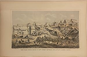
View From School House in 42nd Street Between 2nd & 3rd Av.s Looking North
Verlag: W.C. Rogers & Co, New York, 1868
Anbieter: Argosy Book Store, ABAA, ILAB, New York, NY, USA
Bewertung:

unbound. Lithograph. Image measures 4" x 7". This image shows the east side of 42nd Street in the early stages of its development. Marking some of the northern-most settlement of Manhattan, the area shown here is little more than a shantytown, with small wooden houses built into a rocky terrain. Playing children cavort with scattered livestock such as pigs, goats, and sheep, while the adult residents work with carts and wagons carrying goods. The image appeared in the 1868 edition of Shannon's Manual of the Corporation of the City of New York, an annual compendium of records about city history, city council information, and public works through text, maps, lithographs, and engravings.
-

Zustand: Sehr gut - gebraucht. DVD gut erhalten in Box de en Zustand: 3, Sehr gut - gebraucht, DVD , , Citizen Kane, Orson Wells Joseph Cotten, Agnes Moorehead, Harry Shannon, Ruth Warrick, Dorothy Comingore.
-

Meso Killers: A Saga of Corporate Greed, Lies, and the Painful Deaths of American Workers
Verlag: Amazon Digital Services LLC - Kdp Mär 2020, 2020
ISBN 10: 1633853527ISBN 13: 9781633853522
Buch
Taschenbuch. Zustand: Neu. Neuware.
-

The Adventures of DAKOTAH JOE With His Best Friend TOMMY THE TOAD
Verlag: G Publishing, 2020
ISBN 10: 1732245215ISBN 13: 9781732245211
Buch
Zustand: Hervorragend. Zustand: Hervorragend | Seiten: 32 | Sprache: Englisch.
-

Deliberate Practice in Psychedelic-Assisted Therapy (Essentials of Deliberate Practice Series)
Verlag: American Psychological Associati, 2024
ISBN 10: 1433841711ISBN 13: 9781433841712
Buch
paperback. Zustand: New. BRAND NEW ** SUPER FAST SHIPPING FROM UK WAREHOUSE ** 30 DAY MONEY BACK GUARANTEE.
-
MANUAL OF THE CORPORATION OF THE CITY OF NEW YORK. 1868
Verlag: Common Council, New York, 1869
Anbieter: Second Story Books, ABAA, Rockville, MD, USA
Bewertung:

Hardcover. Octavo; G-/no DJ; Hardcover w/out DJ; Spine, blue with gold print; Boards in blue cloth with gold print, mitred edges, wear to corners and spine caps, stains, soiling, puckering to cloth on rear, toning to spine; Text block has cracked hinges, intermittent spine breaks, mild age-toning to paper, checked against The Society of Iconophiles "Index" (1906) half of the 25 illustrations, some on folded plates, (maps, chromolithographs, engravings, facsimiles, etc.) are missing including the frontispiece map; xiv, 912 pages, frontispiece (port.), illustrated (some color). NOTE: Shelved in Room X, atop one of the bookcases. 1317834. FP New Rockville Stock.
-
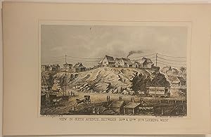
View In Sixth Avenue, Between 55th & 57th St.s Looking West
Verlag: W.C. Rogers & Co, New York, 1868
Anbieter: Argosy Book Store, ABAA, ILAB, New York, NY, USA
Bewertung:
unbound. Lithograph. Image measures 4 1/8" x 6 3/8". Wooden shacks perched atop a rocky hill dominate this view of what would eventually become midtown Manhattan. In the foreground, a trolley and telegraph wires evidence the slow arrival of industrialization to an area filled with horse-drawn carriages and simple buildings. The print is in good condition with full margins. Overall very bright and clean. The image appeared in the 1868 edition of Shannon's Manual of the Corporation of the City of New York, an annual compendium of records about city history, city council information, and public works through text, maps, lithographs, and engravings.
-
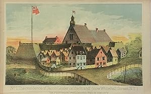
No. 1 The residence of Jacob Leisler on "the Strand" (now Whitehall Street, N.Y.); The First Brick Dwelling Erected in the City
Verlag: New York, 1869
Anbieter: Argosy Book Store, ABAA, ILAB, New York, NY, USA
Bewertung:
unbound. Chromolithograph. Image measures 5.5" x 8". This image shows the estate of Jacob Leisler on what is now Whitehall Street. Jacob Leisler was a German-born colonist in the Province of New York. He gained wealth in New Amsterdam in the fur trade and tobacco business.It is the first brick residence built in the city. An interesting view of Dutch New York The image appeared in the 1869 edition of Shannon's Manual of the Corporation of the City of New York, an annual compendium of records about city history, city council information, and public works through text, maps, lithographs, and engravings.
-

Illuminating Metalwork. Metal, Object, and Image in Medieval Manuscripts. (Sense, Matter and Medium, 4).
Verlag: Berlin: de Gruyter 2021., 2021
Anbieter: Antiquariat Bergische Bücherstube Mewes, Overath, Deutschland
Verbandsmitglied: GIAQ ILAB VDA
Bewertung:
523 S., 184 farb. Abb. Lit.verz. Reg. Kart. *neuwertig* The presence of gold, silver, and other metals is a hallmark of decorated manuscripts, the very characteristic that makes them "illuminated." Medieval artists often used metal pigment and leaf to depict metal objects both real and imagined, such as chalices, crosses, tableware, and even idols; the luminosity of these representations contrasted pointedly with the surrounding paints, enriching the page and dazzling the viewer. To elucidate this key artistic tradition, this volume represents the first in-depth scholarly assessment of the depiction of precious-metal objects in manuscripts and the media used to conjure them. From Paris to the Abbasid caliphate, and from Ethiopia to Bruges, the case studies gathered here forge novel approaches to the materiality and pictoriality of illumination. In exploring the semiotic, material, iconographic, and technical dimensions of these manuscripts, the authors reveal the canny ways in which painters generated metallic presence on the page. Illuminating Metalwork is a landmark contribution to the study of the medieval book and its visual and embodied reception, and is poised to be a staple of research in art history and manuscript studies, accessible to undergraduates and specialists alike.
-

The French College Literary Journal - November 1870 (Vol. IV, No. XXIII)
Verlag: W. B. Kelly / French College, Blackrock, Dublin, 1870
Anbieter: Between the Covers-Rare Books, Inc. ABAA, Gloucester City, NJ, USA
Verbandsmitglied: ABAA ESA ILAB IOBA
Bewertung:
Softcover. Zustand: Very Good. Periodical. Octavo. [167]-196pp. Moderately soiled, chipping to the spine and vertical crease to covers and text, a very good and sound copy. The French College was the original name of Blackrock College, one of Dublin's great Catholic middle class boys schools, so called because it provided a French style of education. Notable Blackrock alumni include Eamon De Valera, Liam O'Flaherty, John Charles McQuaid, Brian O'Nolan and Bob Geldof. This issue includes contributions from: James Doheny, Patrick Cahill, C. Shannon, Arthur F. O'Keeffe, Joseph Peart, and Thomas Fagan. Scarce. *OCLC* locates only two records at the The University of Kansas Archives and The National Archives of Ireland.
-
MANUAL OF THE CORPORATION OF THE CITY OF NEW YORK. 1868
Verlag: Common Council, New York, 1869
Anbieter: Second Story Books, ABAA, Rockville, MD, USA
Bewertung:
Hardcover. Octavo; Fair/no DJ; Hardcover w/out DJ; Spine, brown with gold print; Boards in brown, mild wear to spine caps, hinges, and corners, bump to spine head, mild shelfwear; Text block has inscription in ink on front endpapers, tanning to pages surrounding plates, paper is lightly age-toned, some foxing to plates, checked against The Society of Iconophiles "Index" (1906) some of the numerous illustrations, some on folded plates, (maps, chromolithographs, engravings, facsimiles, etc.) are missing (missing illustrations include frontispiece maps and port., illustrations on pages xiv, 229, 510, 520, 526, 536, 696, 812), also missing pages 803-812; xiv, 912 pages, illustrated (some color). NOTE: Shelved in Room X, atop one of the bookcases. 1317577. FP New Rockville Stock.
-
Interior View of Tammany Hall, Decorated for the National Convention July 4th 1868
Verlag: W.C. Rogers & Co, New York, 1868
Anbieter: Argosy Book Store, ABAA, ILAB, New York, NY, USA
Bewertung:
unbound. Color lithograph. Image measures 12 1/2" x 17 1/2" . Sheet measures 15" x 20". This impressive print shows a grand, patriotic display inside of New York City's Tammany Hall located in Lower Manhattan. The image commemorates the 1868 Democratic National Convention, the first convention to be held after the end of the Civil War. Condition is very good. Part of lower left border missing, does not affect image. Color is vibrant. The image appeared in the 1868 edition of Shannon's Manual of the Corporation of the City of New York, an annual compendium of records about city history, city council information, and public works through text, maps, lithographs, and engravings.
-
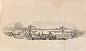
Contemplated East River Bridge
Verlag: E. Jones & Co, New York, 1869
Anbieter: Argosy Book Store, ABAA, ILAB, New York, NY, USA
Bewertung:
hardcover. View. Lithograph. 8 1/2" x 12". This view depicts an early image of what would be the Brooklyn Bridge, the first bridge across the East River from Manhattan to Brooklyn. Folds as issued and some stains, otherwise in good condition. It comes from the 1869 edition the "Manual of the Corporation of the City of New York," which was one of the two manuals published by the New York City Common Council, issued by Joseph Shannon, clerk of the council in 1868 and 1869. The "Manuals of the Corporation" were directories of extensive historical and contemporary records of New York first compiled by D.T. Valentine. These books include detailed information on the meetings of the Aldermen Council, ordinances passed, public officials, the city's debts, directories of hospitals, alms houses and schools, ferry schedules, lists of public porters, demographics and census information, and descriptions of historic buildings and streets. Much of the information was gleaned from Dutch and English sources, as processed by Valentine. By this late date in the publishing of the manuals - the first was released in 1841 and the last in 1870 - the volumes had become extremely lavish, filled with illustrated and full-color folding maps. The 1869 edition is no exception, as it is illustrated throughout with lithographs and engravings of important city landmarks and personalities. There are a number of fold-out maps, including a "Map of the City of New York Showing its Political Divisions and Subdivisions" from August 1869 at the front of the volume. D.T. Valentine (1801-1869) served as the Deputy to the Clerk of the Common Council for thirty-seven years and took it upon himself to compile the "Manuals", which he updated and published annually from 1841-1866. Joseph Shannon succeeded Valentine as Clerk and published the manuals for 1868 and 1869. It is an excellent source of early New York City history, and this view of the Brooklyn Bridge before it was completed in 1883 is a principal facet of that.
-

Map of New York I. with the adjacent Rocks and other remarkable Parts of Hell-Gate
Verlag: Joseph Shannon, New York, 1869
Anbieter: Argosy Book Store, ABAA, ILAB, New York, NY, USA
Bewertung:
unbound. Color lithograph. Measures 8.5" x 10.25" This is an unusual 1868 republication of Thomas Kitchin's 1778 map of New York City and surroundings during the American Revolutionary War. Originally published in The London Magazine, it features the whole of Manhattan as well as western Long Island (part of Brooklyn and Queens today), southwestern Westchester County, and New Jersey along the Hudson. Incredibly detailed, it notes topographical features, roads, areas of settlement, fortifications, and forts. The City of New York extends from to the southern tip of Manhattan to today's City Hall, depicting the relatively small city at the time. Thomas Kitchin (1719-1784) was an English engraver and map-maker. His maps and atlases of England earned him the position of hydrographer to the King. This large map of Poland is an impressive example of his work. The map appeared in the 1869 edition of The Manual of the Corporation of the City of New York by Joseph Shannon, Clerk of the Common Council, an annual compendium of records about city history, city council information, and public works through text, maps, lithographs, and engravings. The "Manuals of the Corporation" were directories of extensive historical and contemporary records of New York first compiled by D.T. Valentine. These books include detailed information on the meetings of the Aldermen Council, ordinances passed, public officials, the city's debts, directories of hospitals, alms houses and schools, ferry schedules, lists of public porters, demographics and census information, and descriptions of historic buildings and streets. Much of the information was gleaned from Dutch and English sources, as processed by Valentine. By this late date in the publishing of the manuals - the first was released in 1841 and the last in 1870 - the volumes had become extremely lavish, filled with illustrated and full-color folding maps. The 1869 edition is no exception, as it is illustrated throughout with lithographs and engravings of important city landmarks and personalities. D.T. Valentine (1801-1869) served as the Deputy to the Clerk of the Common Council for thirty-seven years and took it upon himself to compile the "Manuals", which he updated and published annually from 1841-1866. Joseph Shannon succeeded Valentine as Clerk and published the manuals for 1868 and 1869. The final edition of the manual was published by John Hardy. It is an excellent source of early New York City history.
-

Central Park Guide; 1869 Map of Central Park
Verlag: E. Jones & Co, New York, 1869
Anbieter: Argosy Book Store, ABAA, ILAB, New York, NY, USA
Bewertung:
hardcover. Map. Lithograph. 16.5" x 7.5". This uncommon map of Central Park is as inviting as it is riveting. A 19th century depiction of the roads, trails, and bodies of water in the park, it labels 57 important landmarks, including the famous Central Park Mall, the fountain, the different meadows, and various statues, as well as more helpful sites such as drinking fountains, boat landings, and bathrooms. Additionally, each gate along the border of the park is labeled. It comes from the 1869 edition the "Manual of the Corporation of the City of New York," which was one of the two manuals published by the New York City Common Council, issued by Joseph Shannon, clerk of the council in 1868 and 1869. The "Manuals of the Corporation" were directories of extensive historical and contemporary records of New York first compiled by D.T. Valentine. These books include detailed information on the meetings of the Aldermen Council, ordinances passed, public officials, the city's debts, directories of hospitals, alms houses and schools, ferry schedules, lists of public porters, demographics and census information, and descriptions of historic buildings and streets. Much of the information was gleaned from Dutch and English sources, as processed by Valentine. By this late date in the publishing of the manuals - the first was released in 1841 and the last in 1870 - the volumes had become extremely lavish, filled with illustrated and full-color folding maps. The 1869 edition is no exception, as it is illustrated throughout with lithographs and engravings of important city landmarks and personalities. There are a number of fold-out maps, including a "Map of the City of New York Showing its Political Divisions and Subdivisions" from August 1869 at the front of the volume. D.T. Valentine (1801-1869) served as the Deputy to the Clerk of the Common Council for thirty-seven years and took it upon himself to compile the "Manuals", which he updated and published annually from 1841-1866. Joseph Shannon succeeded Valentine as Clerk and published the manuals for 1868 and 1869. It is an excellent source of early New York City history, and this early Central Park guide is a principal facet of that.
-

New York and Environs
Verlag: W.C. Rogers & Co, New York, 1868
Anbieter: Argosy Book Store, ABAA, ILAB, New York, NY, USA
Bewertung:
unbound. Map. Lithograph. Measures 16" x 12.75". This exceptionally beautiful birds-eye-view of New York was issued in 1868 by D. T. Valentine. Incredibly detailed, the view features Manhattan Island as seen from Jersey City and Hoboken. Parts of Brooklyn, Queens are visible in the background. Showing a stunning level of detail, countless buildings, including churches, are illustrated in profile with individual windows visible. Several ships and boats are featured in the harbor and river, and a train is seen headed east with several people appearing in the foreground. The view is in good condition with minor foxing throughout. Verso repairs along some original fold lines, tight margin lower left. This view appeared in the 1868 edition of The Manual of the Corporation of the City of New York by Joseph Shannon, Clerk of the Common Council, an annual compendium of records about city history, city council information, and public works through text, maps, lithographs, and engravings. The "Manuals of the Corporation" were directories of extensive historical and contemporary records of New York first compiled by D.T. Valentine. Popularly called Valentine's Manuals, the texts were richly illustrated with maps, lithographs, and engravings. D.T. Valentine (1801-1869) served as the Deputy to the Clerk of the Common Council for thirty-seven years and took it upon himself to compile the "Manuals", which he updated and published annually from 1841-1866. Joseph Shannon succeeded Valentine as Clerk and published the manuals for 1868 and 1869. The final edition of the manual was published by John Hardy. By this date in the publishing of the manuals, the volumes had become extremely lavish, filled with illustrated and full-color folding maps. The 1868 edition is no exception, as it is illustrated throughout with lithographs and engravings of important city landmarks and personalities. It is an excellent source of early New York City history.
-

Map of the City of New York, Showing its Political Divisions and Subdivisions
Verlag: Joseph Shannon, New York, 1869
Anbieter: Argosy Book Store, ABAA, ILAB, New York, NY, USA
Bewertung:
unbound. Color lithograph. Image measures 37.5" x 8.5". In good condition. This is a lovely 1869 map of New York City issues by Joseph Shannon. Actually five maps on two sides of a single sheet, each map depicts a different aspect of the political landscape of the city. The large map on recto shows Ward Boundaries, Assembly Districts, and Election Districts. Four smaller maps on verso are divided into Wards and Senate Districts, Wards and Congressional Districts, Wards and School Districts, and Wards and Justice Districts. Each map is incredibly detailed and color coded. Although Central Park is illustrated in each of the smaller maps on verso, it is delineated on the large map. It comes from the 1869 edition the "Manual of the Corporation of the City of New York," which was one of the two manuals published by the New York City Common Council, issued by Joseph Shannon, clerk of the council in 1868 and 1869. The "Manuals of the Corporation" were directories of extensive historical and contemporary records of New York first compiled by D.T. Valentine. These books include detailed information on the meetings of the Aldermen Council, ordinances passed, public officials, the city's debts, directories of hospitals, alms houses and schools, ferry schedules, lists of public porters, demographics and census information, and descriptions of historic buildings and streets. Much of the information was gleaned from Dutch and English sources, as processed by Valentine. By this late date in the publishing of the manuals - the first was released in 1841 and the last in 1870 - the volumes had become extremely lavish, filled with illustrated and full-color folding maps. The 1869 edition is no exception, as it is illustrated throughout with lithographs and engravings of important city landmarks and personalities. D.T. Valentine (1801-1869) served as the Deputy to the Clerk of the Common Council for thirty-seven years and took it upon himself to compile the "Manuals", which he updated and published annually from 1841-1866. Joseph Shannon succeeded Valentine as Clerk and published the manuals for 1868 and 1869. The final edition of the manual was published by John Hardy. It is an excellent source of early New York City history.
-
Manual of the Corporation of the city of New York 1868. (Handbuch der Gesellschaft der Stadt New York 1868.)
Verlag: New York Jones, 1868
Anbieter: Neusser Buch & Kunst Antiquariat, Neuss, NRW, Deutschland
Bewertung:

0. 8° 912 Seiten, mit Titelbild, ausklappbaren Karten und 26 lithografierten Diagrammen und Ansichten. OLwd. Einband mit Rücken- und Deckelvergoldung, berieben und bestossen, hinterer Deckel lose, an den Kapitalen leicht eingerissen, Seiten mit Bräunung. Die "Manuals of the Corporation" waren Verzeichnisse umfangreicher historischer und zeitgenössischer Aufzeichnungen von New York. Diese Bücher enthalten detaillierte Informationen zu den Sitzungen des Aldermen Council, verabschiedeten Verordnungen, Beamten, den Schulden der Stadt, Verzeichnissen von Krankenhäusern, Almosenhäusern und Schulen, Fährplänen, Listen öffentlicher Träger, demografischen Daten und Informationen zur Volkszählung sowie Beschreibungen historischer Gebäude und Straßen. Ein herausstechendes Nachschlagewerk für die frühe Geschichte New Yorks. Sprache: Englischglisch 1,700 gr.
-
Manual of the Corporation of the City of New York, for 1869
Verlag: E. Jones & Co, New York, 1869
Anbieter: Argosy Book Store, ABAA, ILAB, New York, NY, USA
Bewertung:
hardcover. First. Illustrated manual of the Corporation of the City of New York. 896pp. with engraved portraits, fold out maps, lithograph views, etc. Thick 8vo, rebound in yellow buckram. Bookplate "From the Library of William M. Ivins" pasted on inside front cover. Maps and illustrations complete according to the "Index to the Illustrations in the Manuals of the Corporation of the City of New York", published by the Society of Iconophiles, 1906. New York: E. Jones & Co., 1869. This 1869 edition the "Manual of the Corporation of the City of New York" was one of the two manuals published by the New York City Common Council to be issued by Joseph Shannon, clerk of the council in 1868 and 1869. The "Manuals of the Corporation" were directories of extensive historical and contemporary records of New York first compiled by D.T. Valentine. These books include detailed information on the meetings of the Aldermen Council, ordinances passed, public officials, the city's debts, directories of hospitals, alms houses and schools, ferry schedules, lists of public porters, demographics and census information, and descriptions of historic buildings and streets. Much of the information was gleaned from Dutch and English sources, as processed by Valentine. By this late date in the publishing of the manuals - the first was released in 1841 and the last in 1870 - the volumes had become extremely lavish, filled with illustrated and full-color folding maps. The 1869 edition is no exception, as it is illustrated throughout with lithographs and engravings of important city landmarks and personalities. There are a number of fold-out maps, including a "Map of the City of New York Showing its Political Divisions and Subdivisions" from August 1869 at the front of the volume. This example is complete ad has been rebound. D.T. Valentine (1801-1869) served as the Deputy to the Clerk of the Common Council for thirty-seven years and took it upon himself to compile the "Manuals", which he updated and published annually from 1841-1866. Joseph Shannon succeeded Valentine as Clerk and published the manuals for 1868 and 1869. This compendium is an excellent source of early New York City history.
-
Manual of the Corporation for 1868
Verlag: Joseph Shannon, New York, 1868
Anbieter: Argosy Book Store, ABAA, ILAB, New York, NY, USA
Bewertung:
hardcover. Zustand: very good. Illustrated manual of the Corporation of the City of New York. 912 pages with frontispiece, 2 fold out maps and 24 lithographed diagrams and views. Brown buckram with gold stamped spine and covers. Minor scuffing to cover, head and tail of spine. Pages 487-490 loose. Thick 8vo. Corners slightly bumped minor scuffs to cover. Maps and illustrations in excellent condition and complete according to the "Index to the Illustrations in the Manuals of the Corporation of the City of New York", published by the Society of Iconophiles, 1906. New York: 1868. First edition, rare. The "Manuals of the Corporation" were directories of extensive historical and contemporary records of New York first compiled by D.T. Valentine. These books include detailed information on the meetings of the Aldermen Council, ordinances passed, public officials, the city's debts, directories of hospitals, alms houses and schools, ferry schedules, lists of public porters, demographics and census information, and descriptions of historic buildings and streets. Much of the information was gleaned from Dutch and English sources, as processed by Valentine. Notable illustrations in this edition include a view of "Spuyten Duyvel Creek" and "South East View of the City of New York 1768". Maps in this edition include "[Map of] New-York City County, and Vicinity" and "This Plan of the City of New York.was made for the purpose of shewing the progress and extent of the Great Fire which happened in the 1776.". D.T. Valentine (1801-1869) served as the Deputy to the Clerk of the Common Council for thirty-seven years without being promoted to Clerk. Valentine took it upon himself to compile the "Manuals", which he updated and published annually from 1841-1866. Joseph Shannon succeeded Valentine as Clerk and published the manuals for 1868 and 1869. Many copies were personalized for prominent officials. This compendium is an excellent source of early New York City history.
-
Map of the City of New York; Shannon and Rogers rare map of the city of New York
Verlag: Joseph Shannon, New York, 1868
Anbieter: Argosy Book Store, ABAA, ILAB, New York, NY, USA
Bewertung:
unbound. Color lithograph. Measures 7.75" x 40.25" This is a rare and unusual 1868 map of New York City covers the entirety of Manhattan along with some parts of Queens, Brooklyn, and the Bronx. Extraordinarily detailed, it identifies streets, ferry lines, railroads, parks, and several other topographical features. Depth soundings are included in the Hudson and East Rivers. Wards are numbered and color coded. The map also shows former property and lot times, and the property owners' names for a few buildings. Central Park, under construction at the time, is illustrated in detail with the Old and New Reservoirs identified, along with The Ramble. The map appeared in the 1868 edition of The Manual of the Corporation of the City of New York by Joseph Shannon, Clerk of the Common Council, an annual compendium of records about city history, city council information, and public works through text, maps, lithographs, and engravings. The "Manuals of the Corporation" were directories of extensive historical and contemporary records of New York first compiled by D.T. Valentine. These books include detailed information on the meetings of the Aldermen Council, ordinances passed, public officials, the city's debts, directories of hospitals, alms houses and schools, ferry schedules, lists of public porters, demographics and census information, and descriptions of historic buildings and streets. Much of the information was gleaned from Dutch and English sources, as processed by Valentine. By this late date in the publishing of the manuals - the first was released in 1841 and the last in 1870 - the volumes had become extremely lavish, filled with illustrated and full-color folding maps. The 1868 edition is no exception, as it is illustrated throughout with lithographs and engravings of important city landmarks and personalities. D.T. Valentine (1801-1869) served as the Deputy to the Clerk of the Common Council for thirty-seven years and took it upon himself to compile the "Manuals", which he updated and published annually from 1841-1866. Joseph Shannon succeeded Valentine as Clerk and published the manuals for 1868 and 1869. The final edition of the manual was published by John Hardy. It is an excellent source of early New York City history.
-

Map of the upper part of the Island of Manhattan above Eighty-Sixth Street Arranged to Illustrate the Battle of Harlem Heights
Verlag: W.C. Rogers & Co, New York, 1868
Anbieter: Argosy Book Store, ABAA, ILAB, New York, NY, USA
Bewertung:
unbound. Map. Color lithograph. Image measures 14.5" x 24". This incredible 1868 map of Upper Manhattan illustrate the early stages of the American Revolutionary War, specifically the Battle of Harlem Heights. The map shows Upper Manhattan from 81st Street to Fort George and includes the Upper East and West Sides, Morningside Heights, Inwood, Harlem and Washington Heights. Topography and geographical features shown in extensive detail with relief in hachures. Shows street grids, parks, notable buildings, docks, tunnels, waterways and swampland. Central Park is not delineated. The Battle of Harlem Heights was fought during the 1776 New York and New Jersey campaigns of the American Revolutionary War in what is today the Morningside Heights neighborhood. After being defeated in the Battle of Long Island, Washington held a few high ground positions in the northern parts of Manhattan and galvanized his troops against the superior British attackers. The Americans managed to push back the British, resulting in Washington's first battlefield victory of the war. He would however be forced to withdraw from New York later that year. The map indicates colors illustrating the British and American positions in red and blue respectively. A key near the bottom locates the Americans and British troops and the line of march for each. The map is in good condition with some foxing and verso repair along a tear near the left border and original fold lines. The map appeared in the 1868 edition of The Manual of the Corporation of the City of New York by Joseph Shannon, Clerk of the Common Council, an annual compendium of records about city history, city council information, and public works through text, maps, lithographs, and engravings. The "Manuals of the Corporation" were directories of extensive historical and contemporary records of New York first compiled by D.T. Valentine. These books include detailed information on the meetings of the Aldermen Council, ordinances passed, public officials, the city's debts, directories of hospitals, alms houses and schools, ferry schedules, lists of public porters, demographics and census information, and descriptions of historic buildings and streets. Much of the information was gleaned from Dutch and English sources, as processed by Valentine. By this late date in the publishing of the manuals - the first was released in 1841 and the last in 1870 - the volumes had become extremely lavish, filled with illustrated and full-color folding maps. The 1868 edition is no exception, as it is illustrated throughout with lithographs and engravings of important city landmarks and personalities. D.T. Valentine (1801-1869) served as the Deputy to the Clerk of the Common Council for thirty-seven years and took it upon himself to compile the "Manuals", which he updated and published annually from 1841-1866. Joseph Shannon succeeded Valentine as Clerk and published the manuals for 1868 and 1869. The final edition of the manual was published by John Hardy. It is an excellent source of early New York City history.


