Gesamtpreis (1 Artikel Artikel):
Versandziel:

s d u k society diffusion useful knowledge (566 Ergebnisse)
Direkt zu den wichtigsten Suchergebnissen
Suchfilter
Produktart
- Alle Product Types
- Bücher (55)
- Magazine & Zeitschriften (Keine weiteren Ergebnisse entsprechen dieser Verfeinerung)
- Comics (Keine weiteren Ergebnisse entsprechen dieser Verfeinerung)
- Noten (Keine weiteren Ergebnisse entsprechen dieser Verfeinerung)
- Kunst, Grafik & Poster (Keine weiteren Ergebnisse entsprechen dieser Verfeinerung)
- Fotografien (Keine weiteren Ergebnisse entsprechen dieser Verfeinerung)
- Karten (511)
- Manuskripte & Papierantiquitäten (Keine weiteren Ergebnisse entsprechen dieser Verfeinerung)
Zustand Mehr dazu
- Neu (Keine weiteren Ergebnisse entsprechen dieser Verfeinerung)
- Wie Neu, Sehr Gut oder Gut Bis Sehr Gut (Keine weiteren Ergebnisse entsprechen dieser Verfeinerung)
- Gut oder Befriedigend (445)
- Ausreichend oder Schlecht (60)
- Wie beschrieben (61)
Einband
- alle Einbände
- Hardcover (3)
- Softcover (Keine weiteren Ergebnisse entsprechen dieser Verfeinerung)
Weitere Eigenschaften
- Erstausgabe (Keine weiteren Ergebnisse entsprechen dieser Verfeinerung)
- Signiert (Keine weiteren Ergebnisse entsprechen dieser Verfeinerung)
- Schutzumschlag (Keine weiteren Ergebnisse entsprechen dieser Verfeinerung)
- Angebotsfoto (566)
Sprache (1)
Gratisversand
- Kostenloser Versand nach USA (Keine weiteren Ergebnisse entsprechen dieser Verfeinerung)
Land des Verkäufers
Verkäuferbewertung
-

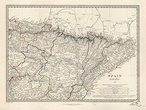
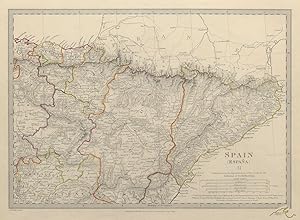
SPAIN (ESPAŃA), II., North-East, Madrid to Mediterranean
Erscheinungsdatum: 1844
Anbieter: Antiqua Print Gallery, London, Vereinigtes Königreich
Verkäuferbewertung 3 von 5 Sternen

Karte
EUR 6,53
Währung umrechnenEUR 11,52 für den Versand von Vereinigtes Königreich nach USAAnzahl: 1 verfügbar
In den WarenkorbZustand: Good. SPAIN NORTH EAST.Cataluna Aragon Soria Navarra Bizcaya Guipozcoa.SDUK 1844 map. Antique steel engraved map with original outline hand colouring (coloring); Engraved by J & C Walker (This map was originally published by Baldwin & Cradock in 1831; this date is printed on the map. This edition of the map was printed and published by Charles Knight in 1844.). 27.0 x 36.0cm, 10.5 x 14.25 inches. Condition: Good. There is nothing printed on the reverse side, which is plain.
-
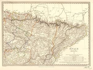
SPAIN (ESPAŃA), II., North-East, Madrid to Mediterranean
Erscheinungsdatum: 1874
Anbieter: Antiqua Print Gallery, London, Vereinigtes Königreich
Verkäuferbewertung 3 von 5 Sternen
Karte
EUR 6,53
Währung umrechnenEUR 11,52 für den Versand von Vereinigtes Königreich nach USAAnzahl: 1 verfügbar
In den WarenkorbZustand: Good. SPAIN NORTH EAST Cataluna Aragon Soria Navarra Bizcaya Guipozcoa SDUK 1874 map. Antique steel engraved map with original outline hand colouring; Engraved by J & C Walker (1874). 28.0 x 38.5cm, 11 x 15 inches. Condition: Good. There is nothing printed on the reverse side, which is plain.
-
SPAIN (ESPAŃA), II., North-East, Madrid to Mediterranean
Erscheinungsdatum: 1846
Anbieter: Antiqua Print Gallery, London, Vereinigtes Königreich
Verkäuferbewertung 3 von 5 Sternen
Karte
EUR 6,53
Währung umrechnenEUR 11,52 für den Versand von Vereinigtes Königreich nach USAAnzahl: 2 verfügbar
In den WarenkorbZustand: Good. SPAIN NORTH EAST. Cataluna Aragon Soria Navarra Guipozcoa Bizcaya. SDUK 1846 map. Antique steel engraved map with original outline hand colouring; Engraved by J & C Walker (The map has been corrected to 1845. This date is printed on the map. The map was published in 1846). 27.5 x 36.5cm, 10.75 x 14.5 inches. Condition: Good. The image shown may have been taken from a different example of this map than that which is offered for sale. The map you will receive is in good condition but there may be minor variations in the condition from that shown in the image which may include some light spotting. This map was coloured by hand at the time of publication, thus the colouration may vary slightly between different examples of the map; the colouring applied to the map you receive may differ slightly from that shown in the image. There is nothing printed on the reverse side, which is plain.
-
SPAIN (ESPAŃA), II., North-East, Madrid to Mediterranean
Erscheinungsdatum: 1848
Anbieter: Antiqua Print Gallery, London, Vereinigtes Königreich
Verkäuferbewertung 3 von 5 Sternen
Karte
EUR 6,53
Währung umrechnenEUR 11,52 für den Versand von Vereinigtes Königreich nach USAAnzahl: 1 verfügbar
In den WarenkorbZustand: Good. SPAIN NORTH EAST.Cataluna Aragon Soria Navarra Bizcaya Guipozcoa.SDUK 1848 map. Antique steel engraved map with original outline hand colouring; Engraved by J & C Walker (This map was originally published by Baldwin & Cradock in 1831; this date is printed on the map. This edition of the map was printed and published by Charles Knight in 1848.). 27.0 x 36.0cm, 10.5 x 14.25 inches. Condition: Good. There is nothing printed on the reverse side, which is plain.
-

SPAIN (ESPAŃA), II., North-East, Madrid to Mediterranean
Erscheinungsdatum: 1844
Anbieter: Antiqua Print Gallery, London, Vereinigtes Königreich
Verkäuferbewertung 3 von 5 Sternen
Karte
EUR 6,53
Währung umrechnenEUR 11,52 für den Versand von Vereinigtes Königreich nach USAAnzahl: 1 verfügbar
In den WarenkorbZustand: Good. SPAIN NORTH EAST.Cataluna Aragon Soria Navarra Bizcaya Guipozcoa.SDUK 1844 map. Antique steel engraved map with original outline hand colouring (coloring); Engraved by J & C Walker (This map was originally published by Baldwin & Cradock in 1831; this date is printed on the map. This edition of the map was printed and published by Chapman & Hall in 1844.). 27.0 x 36.0cm, 10.5 x 14.25 inches. Condition: Good. The image shown may have been taken from a different example of this map than that which is offered for sale. The map you will receive is in good condition but there may be minor variations in the condition from that shown in the image. This map was coloured by hand at the time of publication, thus the colouration may vary slightly between different examples of the map; the colouring applied to the map you receive may differ slightly from that shown in the image. There is nothing printed on the reverse side, which is plain.
-
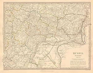
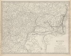
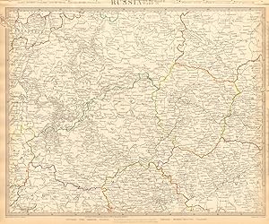
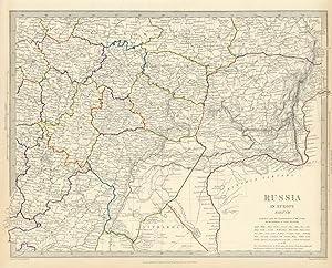
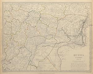
RUSSIA IN EUROPE, PART VII., South East: Moscow to Astrakhan
Erscheinungsdatum: 1845
Anbieter: Antiqua Print Gallery, London, Vereinigtes Königreich
Verkäuferbewertung 3 von 5 Sternen
Karte
EUR 6,53
Währung umrechnenEUR 11,52 für den Versand von Vereinigtes Königreich nach USAAnzahl: 1 verfügbar
In den WarenkorbZustand: Good. RUSSIA. Astrakhan Kostroma Viatra Perm Penza Saratov Kazan Tambor. SDUK 1845 map. Antique steel engraved map with original outline hand colouring; Cartography by Imperial Russian Atlas; engraved by J & C Walker (1845). 32.5 x 41.5cm, 12.75 x 16.25 inches. Condition: Good. There is nothing printed on the reverse side, which is plain.
-
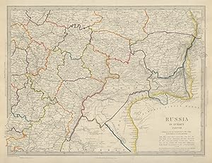
RUSSIA IN EUROPE, PART VII., South East: Moscow to Astrakhan
Erscheinungsdatum: 1874
Anbieter: Antiqua Print Gallery, London, Vereinigtes Königreich
Verkäuferbewertung 3 von 5 Sternen
Karte
EUR 6,53
Währung umrechnenEUR 11,52 für den Versand von Vereinigtes Königreich nach USAAnzahl: 1 verfügbar
In den WarenkorbZustand: Good. RUSSIA Astrakhan Kostroma Viatra Perm Penza Saratov Kazan Tambor SDUK 1874 map. Antique steel engraved map with original outline hand colouring; Cartography by Imperial Russian Atlas; engraved by J & C Walker (1874). 32.5 x 42.5cm, 12.75 x 16.75 inches. Condition: Good. There is nothing printed on the reverse side, which is plain.
-
SPAIN (ESPAŃA), II., North-East, Madrid to Mediterranean
Erscheinungsdatum: 1844
Anbieter: Antiqua Print Gallery, London, Vereinigtes Königreich
Verkäuferbewertung 3 von 5 Sternen
Karte
EUR 6,53
Währung umrechnenEUR 11,52 für den Versand von Vereinigtes Königreich nach USAAnzahl: 2 verfügbar
In den WarenkorbZustand: Good. SPAIN NORTH EAST.Cataluna Aragon Soria Navarra Bizcaya Guipozcoa.SDUK 1844 map. Antique steel engraved map with original outline hand colouring (coloring); Engraved by J & C Walker (This map was originally published by Baldwin & Cradock in 1831; this date is printed on the map. This edition of the map was printed and published by Chapman & Hall in 1844.). 27.0 x 36.0cm, 10.5 x 14.25 inches. Condition: Good. The image shown may have been taken from a different example of this map than that which is offered for sale. The map you will receive is in good condition but there may be minor variations in the condition from that shown in the image. This map was coloured by hand at the time of publication, thus the colouration may vary slightly between different examples of the map; the colouring applied to the map you receive may differ slightly from that shown in the image. There is nothing printed on the reverse side, which is plain.
-
RUSSIA IN EUROPE, PART VII., South East: Moscow to Astrakhan
Erscheinungsdatum: 1844
Anbieter: Antiqua Print Gallery, London, Vereinigtes Königreich
Verkäuferbewertung 3 von 5 Sternen
Karte
EUR 7,12
Währung umrechnenEUR 11,52 für den Versand von Vereinigtes Königreich nach USAAnzahl: 1 verfügbar
In den WarenkorbZustand: Good. RUSSIA.Astrakhan Kostroma Viatra Perm Penza Saratov Kazan Tambor.SDUK 1844 map. Antique steel engraved map with original outline hand colouring (coloring); Cartography from the Imperial Atlas of Russia in Europe; engraved by J & C Walker (This map was originally published by Baldwin & Cradock in 1835; this date is printed on the map. This edition of the map was printed and published by Charles Knight in 1844.). 32.0 x 40.0cm, 12.5 x 15.5 inches. Condition: Good. There is nothing printed on the reverse side, which is plain.
-
RUSSIA IN EUROPE, PART VII., South East: Moscow to Astrakhan
Erscheinungsdatum: 1844
Anbieter: Antiqua Print Gallery, London, Vereinigtes Königreich
Verkäuferbewertung 3 von 5 Sternen
Karte
EUR 7,12
Währung umrechnenEUR 11,52 für den Versand von Vereinigtes Königreich nach USAAnzahl: 1 verfügbar
In den WarenkorbZustand: Good. RUSSIA.Astrakhan Kostroma Viatra Perm Penza Saratov Kazan Tambor SDUK 1844 map. Antique steel engraved map; Cartography from the Imperial Atlas of Russia in Europe; engraved by J & C Walker (This map was originally published by Baldwin & Cradock in 1835; this date is printed on the map. This edition of the map was printed and published by Chapman & Hall in 1844.). 32.0 x 40.0cm, 12.5 x 15.5 inches. Condition: Good. There is nothing printed on the reverse side, which is plain.
-
RUSSIA IN EUROPE, PART VII., South East: Moscow to Astrakhan
Erscheinungsdatum: 1844
Anbieter: Antiqua Print Gallery, London, Vereinigtes Königreich
Verkäuferbewertung 3 von 5 Sternen
Karte
EUR 7,12
Währung umrechnenEUR 11,52 für den Versand von Vereinigtes Königreich nach USAAnzahl: 5 verfügbar
In den WarenkorbZustand: Good. RUSSIA.Astrakhan Kostroma Viatra Perm Penza Saratov Kazan Tambor.SDUK 1844 map. Antique steel engraved map with original outline hand colouring (coloring); Cartography from the Imperial Atlas of Russia in Europe; engraved by J & C Walker (This map was originally published by Baldwin & Cradock in 1835; this date is printed on the map. This edition of the map was printed and published by Chapman & Hall in 1844.). 32.0 x 40.0cm, 12.5 x 15.5 inches. Condition: Good. The image shown may have been taken from a different example of this map than that which is offered for sale. The map you will receive is in good condition but there may be minor variations in the condition from that shown in the image. This map was coloured by hand at the time of publication, thus the colouration may vary slightly between different examples of the map; the colouring applied to the map you receive may differ slightly from that shown in the image. There is nothing printed on the reverse side, which is plain.
-
GERMANY (DEUTSCHLAND), I., The Prussian States, Saxony &c
Erscheinungsdatum: 1874
Anbieter: Antiqua Print Gallery, London, Vereinigtes Königreich
Verkäuferbewertung 3 von 5 Sternen
Karte
EUR 7,72
Währung umrechnenEUR 11,52 für den Versand von Vereinigtes Königreich nach USAAnzahl: 1 verfügbar
In den WarenkorbZustand: Good. GERMANY DEUTSCHLAND Holstein Hanover Mecklenburg Prussia Saxony SDUK 1874 map. Antique steel engraved map with original outline hand colouring; Cartography by Le Coq, Anton, Klein, Coulon; engraved by J & C Walker (1874). 34.5 x 41.5cm, 13.5 x 16.25 inches. Condition: Good. There is nothing printed on the reverse side, which is plain.
-
GERMANY (DEUTSCHLAND), I., Holstein, Hanover, Mecklenburg, Prussian States, Saxony etc
Erscheinungsdatum: 1845
Anbieter: Antiqua Print Gallery, London, Vereinigtes Königreich
Verkäuferbewertung 3 von 5 Sternen
Karte
EUR 7,72
Währung umrechnenEUR 11,52 für den Versand von Vereinigtes Königreich nach USAAnzahl: 2 verfügbar
In den WarenkorbZustand: Good. NORTHERN GERMANY. Holstein Hanover Mecklenburg Prussia Saxony. SDUK 1845 map. Antique steel engraved map with original outline hand colouring; Cartography by Le Coq, Anton, Klein, Coulon; engraved by J & C Walker (1845). 35.0 x 41.0cm, 13.75 x 16.25 inches. Condition: Good. There is nothing printed on the reverse side, which is plain.
-
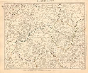
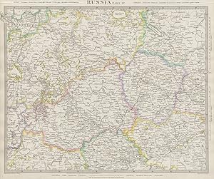
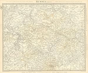
RUSSIA, PART IV., Novgorod Tver Smolensk Vologda Iarolslav Moskva (Moscow) Vladimir. St. Petersburg to Moscow.
Erscheinungsdatum: 1845
Anbieter: Antiqua Print Gallery, London, Vereinigtes Königreich
Verkäuferbewertung 3 von 5 Sternen
Karte
EUR 8,31
Währung umrechnenEUR 11,52 für den Versand von Vereinigtes Königreich nach USAAnzahl: 2 verfügbar
In den WarenkorbZustand: Good. RUSSIA. Novgorod Tver Smolensk Vologda Iarolslav Moscow Vladimir. SDUK 1845 map. Antique steel engraved map with original outline hand colouring; Cartography by Imperial Russian Atlas; engraved by J & C Walker (1845). 34.5 x 41.5cm, 13.5 x 16.25 inches. Condition: Good. There is nothing printed on the reverse side, which is plain.
-

GERMANY (DEUTSCHLAND), I., Holstein, Hanover, Mecklenburg, Prussian States, Saxony etc
Erscheinungsdatum: 1844
Anbieter: Antiqua Print Gallery, London, Vereinigtes Königreich
Verkäuferbewertung 3 von 5 Sternen
Karte
EUR 8,31
Währung umrechnenEUR 11,52 für den Versand von Vereinigtes Königreich nach USAAnzahl: 1 verfügbar
In den WarenkorbZustand: Good. GERMANY DEUTSCHLAND.Holstein Hanover Mecklenburg Prussia Saxony.SDUK 1844 map. Antique steel engraved map with original outline hand colouring (coloring); Cartography by Le Coq, Anton, Klein, Coulon; engraved by J & C Walker (This map was originally published by Baldwin & Cradock in 1833; this date is printed on the map. This edition of the map was printed and published by Charles Knight in 1844.). 32.0 x 40.0cm, 12.5 x 15.5 inches. Condition: Good. Light spotting. There is nothing printed on the reverse side, which is plain.
-
GERMANY (DEUTSCHLAND), III., Baden, Wurtemberg, Bavaria, Tyrol and Switzerland
Erscheinungsdatum: 1874
Anbieter: Antiqua Print Gallery, London, Vereinigtes Königreich
Verkäuferbewertung 3 von 5 Sternen
Karte
EUR 8,31
Währung umrechnenEUR 11,52 für den Versand von Vereinigtes Königreich nach USAAnzahl: 1 verfügbar
In den WarenkorbZustand: Good. GERMANY SOUTH, SWITZERLAND AUSTRIA Baden Württemberg Bavaria Tyrol SDUK 1874 map. Antique steel engraved map with original outline hand colouring; Cartography by Raglovich, Keller, Fallon; engraved by J & C Walker (1874). 41.0 x 35.0cm, 16 x 13.75 inches. Condition: Good. There is nothing printed on the reverse side, which is plain.
-

GERMANY (DEUTSCHLAND), I., Holstein, Hanover, Mecklenburg, Prussian States, Saxony etc
Erscheinungsdatum: 1844
Anbieter: Antiqua Print Gallery, London, Vereinigtes Königreich
Verkäuferbewertung 3 von 5 Sternen
Karte
EUR 8,31
Währung umrechnenEUR 11,52 für den Versand von Vereinigtes Königreich nach USAAnzahl: 4 verfügbar
In den WarenkorbZustand: Good. GERMANY DEUTSCHLAND.Holstein Hanover Mecklenburg Prussia Saxony.SDUK 1844 map. Antique steel engraved map with original outline hand colouring (coloring); Cartography by Le Coq, Anton, Klein, Coulon; engraved by J & C Walker (This map was originally published by Baldwin & Cradock in 1833; this date is printed on the map. This edition of the map was printed and published by Chapman & Hall in 1844.). 32.0 x 40.0cm, 12.5 x 15.5 inches. Condition: Good. The image shown may have been taken from a different example of this map than that which is offered for sale. The map you will receive is in good condition but there may be minor variations in the condition from that shown in the image. This map was coloured by hand at the time of publication, thus the colouration may vary slightly between different examples of the map; the colouring applied to the map you receive may differ slightly from that shown in the image. There is nothing printed on the reverse side, which is plain.
-
GERMANY (DEUTSCHLAND), III., Baden, Wurtemberg, Bavaria, Tyrol and Switzerland
Erscheinungsdatum: 1848
Anbieter: Antiqua Print Gallery, London, Vereinigtes Königreich
Verkäuferbewertung 3 von 5 Sternen
Karte
EUR 8,91
Währung umrechnenEUR 11,52 für den Versand von Vereinigtes Königreich nach USAAnzahl: 1 verfügbar
In den WarenkorbZustand: Good. GERMANY SWITZERLAND AUSTRIA. Baden, Württemberg, Bavaria, Tyrol. SDUK 1848 map. Antique steel engraved map with original outline hand colouring; Cartography by Raglovich, Keller, Fallon; engraved by J & C Walker (This map was originally published by Baldwin & Cradock in 1832; this date is printed on the map. This edition of the map was printed and published by Charles Knight in 1848.). 40.0 x 32.0cm, 15.5 x 12.5 inches. Condition: Good. There is nothing printed on the reverse side, which is plain.
-
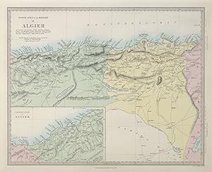
NORTH AFRICA OR BARBARY, II., ALGIER
Erscheinungsdatum: 1857
Anbieter: Antiqua Print Gallery, London, Vereinigtes Königreich
Verkäuferbewertung 3 von 5 Sternen
Karte
EUR 8,91
Währung umrechnenEUR 11,52 für den Versand von Vereinigtes Königreich nach USAAnzahl: 1 verfügbar
In den WarenkorbZustand: Good. NORTH AFRICA OR BARBARY II. ALGIER. Algeria Algiers. SDUK 1857 old antique map. Antique steel engraved map with original hand colouring; Engraved by J & C Walker (1857). 33.0 x 41.0cm, 13 x 16 inches. Condition: Good. There is nothing printed on the reverse side, which is plain.
-
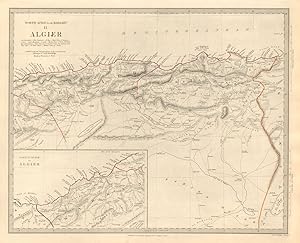
NORTH AFRICA OR BARBARY, II., ALGIER. .
Erscheinungsdatum: 1846
Anbieter: Antiqua Print Gallery, London, Vereinigtes Königreich
Verkäuferbewertung 3 von 5 Sternen
Karte
EUR 8,91
Währung umrechnenEUR 11,52 für den Versand von Vereinigtes Königreich nach USAAnzahl: 1 verfügbar
In den WarenkorbZustand: Good. NORTH AFRICA OR BARBARY II. ALGIER. Algeria Algiers. SDUK 1846 old antique map. Antique steel engraved map with original outline hand colouring; Engraved by J & C Walker (1846). 33.0 x 41.0cm, 13 x 16 inches. Condition: Good. The image shown may have been taken from a different example of this map than that which is offered for sale. The map you will receive is in good condition but there may be minor variations in the condition from that shown in the image which may include some light spotting. This map was coloured by hand at the time of publication, thus the colouration may vary slightly between different examples of the map; the colouring applied to the map you receive may differ slightly from that shown in the image. There is nothing printed on the reverse side, which is plain.
-
GERMANY (DEUTSCHLAND), IV., Austrian Dominions, I. Bohemia, Moravia, Austria, Styria, Illyria, Croatia, Sclavonia and Western Hungary
Erscheinungsdatum: 1845
Anbieter: Antiqua Print Gallery, London, Vereinigtes Königreich
Verkäuferbewertung 3 von 5 Sternen
Karte
EUR 8,91
Währung umrechnenEUR 11,52 für den Versand von Vereinigtes Königreich nach USAAnzahl: 2 verfügbar
In den WarenkorbZustand: Good. AUSTRIAN DOMINION. Bohemia Moravia Styria Illyria Croatia Hungary. SDUK 1845 map. Antique steel engraved map with original outline hand colouring; Cartography by Fallon, Lipsky; engraved by J & C Walker (The map was originally published in 1832, and is indicated to be corrected to 1843. These dates are printed on the map. This edition of the map was published in 1845). 41.0 x 33.0cm, 16.25 x 12.75 inches. Condition: Good. There is nothing printed on the reverse side, which is plain.
-

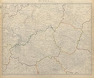
RUSSIA, PART IV., Novgorod Tver Smolensk Vologda Iarolslav Moskva (Moscow) Vladimir. St. Petersburg to Moscow.
Erscheinungsdatum: 1844
Anbieter: Antiqua Print Gallery, London, Vereinigtes Königreich
Verkäuferbewertung 3 von 5 Sternen
Karte
EUR 9,50
Währung umrechnenEUR 11,52 für den Versand von Vereinigtes Königreich nach USAAnzahl: 1 verfügbar
In den WarenkorbZustand: Good. RUSSIA.Novgorod Tver Smolensk Vologda Iarolslav Moscow Vladimir.SDUK 1844 map. Antique steel engraved map with original outline hand colouring (coloring); Cartography from the Imperial Atlas of Russia in Europe; engraved by J & C Walker (This map was originally published by Baldwin & Cradock in 1834; this date is printed on the map. This edition of the map was printed and published by Charles Knight in 1844.). 32.0 x 40.0cm, 12.5 x 15.5 inches. Condition: Good. There is nothing printed on the reverse side, which is plain.
-
RUSSIA, PART IV., Novgorod Tver Smolensk Vologda Iarolslav Moskva (Moscow) Vladimir. St. Petersburg to Moscow.
Erscheinungsdatum: 1844
Anbieter: Antiqua Print Gallery, London, Vereinigtes Königreich
Verkäuferbewertung 3 von 5 Sternen
Karte
EUR 9,50
Währung umrechnenEUR 11,52 für den Versand von Vereinigtes Königreich nach USAAnzahl: 1 verfügbar
In den WarenkorbZustand: Good. RUSSIA Moscow Novgorod Smolensk Tver Vologda Iarolslav Vladimir SDUK 1844 map. Antique steel engraved map; Cartography from the Imperial Atlas of Russia in Europe; engraved by J & C Walker (This map was originally published by Baldwin & Cradock in 1834; this date is printed on the map. This edition of the map was printed and published by Charles Knight in 1844.). 32.0 x 40.0cm, 12.5 x 15.5 inches. Condition: Good. Light spotting. There is nothing printed on the reverse side, which is plain.
-
RUSSIA, PART IV., Novgorod Tver Smolensk Vologda Iarolslav Moskva (Moscow) Vladimir. St. Petersburg to Moscow.
Erscheinungsdatum: 1844
Anbieter: Antiqua Print Gallery, London, Vereinigtes Königreich
Verkäuferbewertung 3 von 5 Sternen
Karte
EUR 9,50
Währung umrechnenEUR 11,52 für den Versand von Vereinigtes Königreich nach USAAnzahl: 2 verfügbar
In den WarenkorbZustand: Good. RUSSIA Moscow Novgorod Smolensk Tver Vologda Iarolslav Vladimir SDUK 1844 map. Antique steel engraved map with original outline hand colouring (coloring); Cartography from the Imperial Atlas of Russia in Europe; engraved by J & C Walker (This map was originally published by Baldwin & Cradock in 1834; this date is printed on the map. This edition of the map was printed and published by Chapman & Hall in 1844.). 32.0 x 40.0cm, 12.5 x 15.5 inches. Condition: Good. The image shown may have been taken from a different example of this map than that which is offered for sale. The map you will receive is in good condition but there may be minor variations in the condition from that shown in the image. This map was coloured by hand at the time of publication, thus the colouration may vary slightly between different examples of the map; the colouring applied to the map you receive may differ slightly from that shown in the image. There is nothing printed on the reverse side, which is plain.
-
RUSSIA, PART IV., Novgorod Tver Smolensk Vologda Iarolslav Moskva (Moscow) Vladimir. St. Petersburg to Moscow.
Erscheinungsdatum: 1844
Anbieter: Antiqua Print Gallery, London, Vereinigtes Königreich
Verkäuferbewertung 3 von 5 Sternen
Karte
EUR 9,50
Währung umrechnenEUR 11,52 für den Versand von Vereinigtes Königreich nach USAAnzahl: 1 verfügbar
In den WarenkorbZustand: Good. RUSSIA.Novgorod Tver Smolensk Vologda Iarolslav Moscow Vladimir SDUK 1844 map. Antique steel engraved map with original outline hand colouring (coloring); Cartography from the Imperial Atlas of Russia in Europe; engraved by J & C Walker (This map was originally published by Baldwin & Cradock in 1834; this date is printed on the map. This edition of the map was printed and published by Chapman & Hall in 1844.). 32.0 x 40.0cm, 12.5 x 15.5 inches. Condition: Good. The top margin has been restored. There is nothing printed on the reverse side, which is plain.
-
RUSSIA, PART IV., Novgorod Tver Smolensk Vologda Iarolslav Moskva (Moscow) Vladimir. St. Petersburg to Moscow.
Erscheinungsdatum: 1844
Anbieter: Antiqua Print Gallery, London, Vereinigtes Königreich
Verkäuferbewertung 3 von 5 Sternen
Karte
EUR 9,50
Währung umrechnenEUR 11,52 für den Versand von Vereinigtes Königreich nach USAAnzahl: 2 verfügbar
In den WarenkorbZustand: Fair. RUSSIA.Novgorod Tver Smolensk Vologda Iarolslav Moscow Vladimir.SDUK 1844 map. Antique steel engraved map with original outline hand colouring (coloring); Cartography from the Imperial Atlas of Russia in Europe; engraved by J & C Walker (This map was originally published by Baldwin & Cradock in 1834; this date is printed on the map. This edition of the map was printed and published by Chapman & Hall in 1844.). 32.0 x 40.0cm, 12.5 x 15.5 inches. Condition: Fair: The top of the title (above the map) has been cropped slightly, and there is some damage to the paper along the top edge where the map was bound in. There is nothing printed on the reverse side, which is plain.
-

GERMANY (DEUTSCHLAND), IV., Austrian Dominions, I. Bohemia, Moravia, Austria, Styria, Illyria, Croatia, Sclavonia and Western Hungary
Erscheinungsdatum: 1844
Anbieter: Antiqua Print Gallery, London, Vereinigtes Königreich
Verkäuferbewertung 3 von 5 Sternen
Karte
EUR 10,09
Währung umrechnenEUR 11,52 für den Versand von Vereinigtes Königreich nach USAAnzahl: 1 verfügbar
In den WarenkorbZustand: Good. AUSTRIAN DOMINION.Bohemia Moravia Styria Illyria Croatia Hungary.SDUK 1844 map. Antique steel engraved map with original outline hand colouring (coloring); Cartography by Fallon, Lipsky; engraved by J & C Walker (This map was originally published by Baldwin & Cradock in 1832; this date is printed on the map. This edition of the map was printed and published by Charles Knight in 1844.). 40.0 x 32.0cm, 15.5 x 12.5 inches. Condition: Good. There is nothing printed on the reverse side, which is plain.
-

GERMANY (DEUTSCHLAND), IV., Austrian Dominions, I. Bohemia, Moravia, Austria, Styria, Illyria, Croatia, Sclavonia and Western Hungary
Erscheinungsdatum: 1844
Anbieter: Antiqua Print Gallery, London, Vereinigtes Königreich
Verkäuferbewertung 3 von 5 Sternen
Karte
EUR 10,09
Währung umrechnenEUR 11,52 für den Versand von Vereinigtes Königreich nach USAAnzahl: 1 verfügbar
In den WarenkorbZustand: Good. AUSTRIAN DOMINION.Bohemia Moravia Styria Illyria Croatia Hungary.SDUK 1844 map. Antique steel engraved map with original outline hand colouring (coloring); Cartography by Fallon, Lipsky; engraved by J & C Walker (This map was originally published by Baldwin & Cradock in 1832; this date is printed on the map. This edition of the map was printed and published by Chapman & Hall in 1844.). 40.0 x 32.0cm, 15.5 x 12.5 inches. Condition: Good. The image shown may have been taken from a different example of this map than that which is offered for sale. The map you will receive is in good condition but there may be minor variations in the condition from that shown in the image. This map was coloured by hand at the time of publication, thus the colouration may vary slightly between different examples of the map; the colouring applied to the map you receive may differ slightly from that shown in the image. There is nothing printed on the reverse side, which is plain.
-
France, III., South, from Poitiers to the Mediterranean
Erscheinungsdatum: 1848
Anbieter: Antiqua Print Gallery, London, Vereinigtes Königreich
Verkäuferbewertung 3 von 5 Sternen
Karte
EUR 10,09
Währung umrechnenEUR 11,52 für den Versand von Vereinigtes Königreich nach USAAnzahl: 1 verfügbar
In den WarenkorbZustand: Good. FRANCE STH.Aquitaine Pyrénées Provence Languedoc Rhône Auvergne.SDUK 1848 map. Antique steel engraved map with original outline hand colouring; Engraved by J & C Walker (This map was originally published by Baldwin & Cradock in 1831; this date is printed on the map. This edition of the map was printed and published by Charles Knight in 1848.). 29.0 x 40.5cm, 11.25 x 16 inches. Condition: Good. There is nothing printed on the reverse side, which is plain.
-
NORTH AMERICA, SHEET VIII., Ohio, with parts of Kentucky and Virginia
Erscheinungsdatum: 1844
Anbieter: Antiqua Print Gallery, London, Vereinigtes Königreich
Verkäuferbewertung 3 von 5 Sternen
Karte
EUR 10,09
Währung umrechnenEUR 11,52 für den Versand von Vereinigtes Königreich nach USAAnzahl: 1 verfügbar
In den WarenkorbZustand: Fair. Ohio with parts of Kentucky, Virginia & Indiana. USA. Counties SDUK 1844 map. Antique steel engraved map with original outline hand colouring (coloring); Cartography by Tanner; engraved by J & C Walker (This map was originally published by Baldwin & Cradock in 1833; this date is printed on the map. This edition of the map was printed and published by Chapman & Hall in 1844.). 39.0 x 33.0cm, 15.5 x 13 inches. Condition: Fair: Tide mark in top right corner. Blemish in margin. There is nothing printed on the reverse side, which is plain.