
Gesamtpreis (1 Artikel Artikel):
Versandziel:

rapkin john (325 Ergebnisse)
Direkt zu den wichtigsten Suchergebnissen
Produktart
- Alle Product Types
- Bücher (140)
- Magazine & Zeitschriften
- Comics
- Noten
- Kunst, Grafik & Poster (1)
- Fotografien
- Karten (184)
- Manuskripte & Papierantiquitäten
Zustand
Einband
- alle Einbände
- Hardcover
- Softcover (4)
Weitere Eigenschaften
- Erstausgabe (5)
- Signiert
- Schutzumschlag
- Angebotsfoto (298)
Gratisversand
- Versand nach USA gratis
Land des Verkäufers
Verkäuferbewertung
-
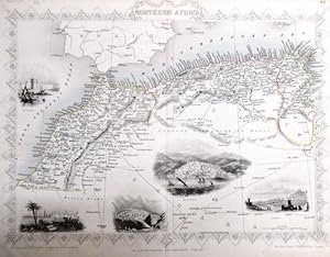
steal engraving / Grenzcolorierter Stahlstich Northern Africa. Mit weiteren 5 Bildstahlstichen 1)Mogador. 2) Marocco. 3) Constantine. 4) Algiers. 5)Tunis.
Verlag: The London Printing and Publishing Company. o.J. [ca 1850], 1850
Erstausgabe
Softcover. Blattgröße 27x36 cm, Stichgröße 21 x 30 cm, mittig längs gefaltet. Die Tafel mit floraler Rahmung, eingezeichneten Längen- und Breitengraden und Maßstabsangabe. Das Blatt an den Rändern und in der Querfalte leicht lichtrandig und fingerfleckig, an der linken unteren Ecke eine Faltstelle, sonst schönes Exemplar. --- In english language. Good condition. Die Tafel beschriftet mit der Ziffer 61. Wahrscheinlich die entsprechende Tafel aus dem Werk von John Tallis: Illustrated atlas and modern history of the world. -- Zu dekorativen Zwecken, zum Rahmen geeignet. Weitere Karten aus dem gleichen Werk vorhanden. "John Rapkin was a mapmaker who was concerned with the aesthetic value of his work as well as cartographic content. His fine maps are distinguished by the trademark decorative borders, vignettes and title displays. Rapkin worked in close association with the equally respected publisher John Tallis. The publishing rights of many of the maps passed to The London Printing and Publishing Company circa 1850. " -- Bitte Portokosten außerhalb EU erfragen! / Please ask for postage costs outside EU! / S ' il vous plait demander des frais de port en dehors de l ' UE! -- Genießen Sie den Sommer und bestellen Sie was zum Lesen! GM25-502030.
-

Holland, antique map with vignette views
Verlag: John Tallis & Co., London, 1854
Anbieter: Antipodean Books, Maps & Prints, ABAA, Garrison, NY, USA
Verbandsmitglied: ABAA ANZAAB ESA ILAB
Bewertung:

Maps. Steel engraved map from the famous Victorian publisher John Tallis, well-known for the attractive vignette views surrounding the maps, which illustrate the peoples & customs of the region. 9 3/4 x 13 1/2" plus margins. Attractive decorative border around edge, very good condition.
-
Turkey in Europe, antique map with vignette views
Verlag: John Tallis & Co., London, 1854
Anbieter: Antipodean Books, Maps & Prints, ABAA, Garrison, NY, USA
Verbandsmitglied: ABAA ANZAAB ESA ILAB
Bewertung:
Maps. Steel engraved map from the famous Victorian publisher John Tallis, well-known for the attractive vignette views surrounding the maps, which illustrate the peoples & customs of the region. 12 1/2 x 10" plus margins. Attractive decorative border around edge, period outline color, very good condition.
-
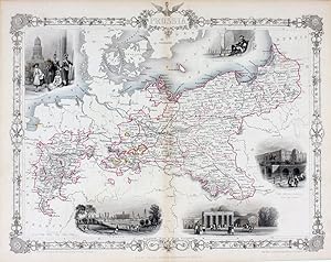
Prussia, antique map with vignette views
Verlag: John Tallis & Co., London, 1854
Anbieter: Antipodean Books, Maps & Prints, ABAA, Garrison, NY, USA
Verbandsmitglied: ABAA ANZAAB ESA ILAB
Bewertung:
Maps. Steel engraved map from the famous Victorian publisher John Tallis, well-known for the attractive vignette views surrounding the maps, which illustrate the peoples & customs of the region. 12 1/2 x 10" plus margins. Attractive decorative border around edge, period outline color, very good condition.
-
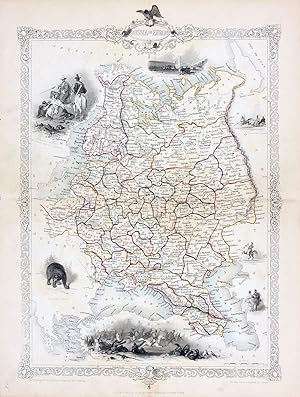
Russia in Europe, antique map with vignette views
Verlag: John Tallis & Co., London, 1854
Anbieter: Antipodean Books, Maps & Prints, ABAA, Garrison, NY, USA
Verbandsmitglied: ABAA ANZAAB ESA ILAB
Bewertung:
Maps. Steel engraved map from the famous Victorian publisher John Tallis, well-known for the attractive vignette views surrounding the maps, which illustrate the peoples & customs of the region. 9 1/2 x 13 1/2" plus margins. Attractive decorative border around edge, period outline color, very good condition.
-
Belgium, antique map with vignette views
Verlag: John Tallis & Co., London, 1854
Anbieter: Antipodean Books, Maps & Prints, ABAA, Garrison, NY, USA
Verbandsmitglied: ABAA ANZAAB ESA ILAB
Bewertung:
Maps. Steel engraved map from the famous Victorian publisher John Tallis, well-known for the attractive vignette views surrounding the maps, which illustrate the peoples & customs of the region. 12 1/2 x 10" plus margins. Attractive decorative border around edge, original hand color. Very good condition.
-
British Guayana, antique map with vignette views
Verlag: John Tallis & Co., London, 1854
Anbieter: Antipodean Books, Maps & Prints, ABAA, Garrison, NY, USA
Verbandsmitglied: ABAA ANZAAB ESA ILAB
Bewertung:
Maps. Steel engraved map from the famous Victorian publisher John Tallis, well-known for the attractive vignette views surrounding the maps, which illustrate the peoples & customs of the region. Vignettes include: Georgetown, Christmas Cataract, New Amsterdam, and Ataraipu or the Devil's Rock. 10 x 12 1/2" plus margins. Attractive decorative border around edge, period outline color, very good condition.
-
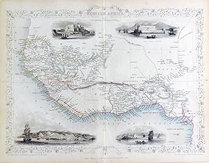
Western Africa, antique map with vignette views
Verlag: John Tallis & Co., London, 1854
Anbieter: Antipodean Books, Maps & Prints, ABAA, Garrison, NY, USA
Verbandsmitglied: ABAA ANZAAB ESA ILAB
Bewertung:
Maps. Steel engraved map from the famous Victorian publisher John Tallis, well-known for the attractive vignette views surrounding the maps, which illustrate the peoples & customs of the region. 12 1/2 x 10" plus margins. Attractive decorative border around edge, period outline color, very good condition.
-
Belgium, antique map with vignette views
Verlag: John Tallis & Co., London, 1854
Anbieter: Antipodean Books, Maps & Prints, ABAA, Garrison, NY, USA
Verbandsmitglied: ABAA ANZAAB ESA ILAB
Bewertung:
Maps. Steel engraved map from the famous Victorian publisher John Tallis, well-known for the attractive vignette views surrounding the maps, which illustrate the peoples & customs of the region. 12 1/2 x 10" plus margins. Attractive decorative border around edge, original hand color. Very good condition.
-
Russia in Europe, antique map with vignette views
Verlag: John Tallis & Co., London, 1854
Anbieter: Antipodean Books, Maps & Prints, ABAA, Garrison, NY, USA
Verbandsmitglied: ABAA ANZAAB ESA ILAB
Bewertung:
Maps. Steel engraved map from the famous Victorian publisher John Tallis, well-known for the attractive vignette views surrounding the maps, which illustrate the peoples & customs of the region. 9 1/2 x 13 1/2" plus margins. Attractive decorative border around edge, period outline color, small archival repair at center, o/w very good condition.
-
Germany, antique map with vignette views
Verlag: John Tallis & Co., London, 1854
Anbieter: Antipodean Books, Maps & Prints, ABAA, Garrison, NY, USA
Verbandsmitglied: ABAA ANZAAB ESA ILAB
Bewertung:
Maps. Steel engraved map from the famous Victorian publisher John Tallis, well-known for the attractive vignette views surrounding the maps, which illustrate the peoples & customs of the region. 9 1/2 x 13 1/2" plus margins. Attractive decorative border around edge, period outline color, very good condition.
-
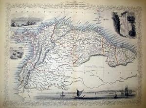
Venezuela, New Granada, Equador, and The Guayanas, antique map with vignette views
Verlag: John Tallis & Co., London, 1854
Anbieter: Antipodean Books, Maps & Prints, ABAA, Garrison, NY, USA
Verbandsmitglied: ABAA ANZAAB ESA ILAB
Bewertung:
Maps. Steel engraved map from the famous Victorian publisher John Tallis, well-known for the attractive vignette views surrounding the maps, which illustrate the peoples & customs of that region. 10 x 13 1/2" plus margins. Attractive decorative border around edge, period outline color, very good condition.
-
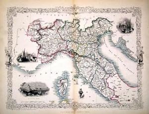
Northern Italy, antique map with vignette views
Verlag: John Tallis & Co., London, 1854
Anbieter: Antipodean Books, Maps & Prints, ABAA, Garrison, NY, USA
Verbandsmitglied: ABAA ANZAAB ESA ILAB
Bewertung:
Maps. Map of Northern Italy ending in Naples and including Corsica. Steel engraved map from the famous Victorian publisher John Tallis, well-known for the attractive vignette views surrounding the maps, which illustrate the peoples & customs of that region. 10 x 13 1/2" plus margins. Attractive decorative border around edge, period outline color, very good condition.
-
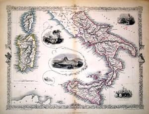
Southern Italy, antique map with vignette views
Verlag: John Tallis & Co., London, 1854
Anbieter: Antipodean Books, Maps & Prints, ABAA, Garrison, NY, USA
Verbandsmitglied: ABAA ANZAAB ESA ILAB
Bewertung:
Maps. Map of Southern Italy from Rome down and including Corsica, Sardinia, and Sicily. Steel engraved map from the famous Victorian publisher John Tallis, well-known for the attractive vignette views surrounding the maps, which illustrate the peoples & customs of that region. 10 x 13 1/2" plus margins. Attractive decorative border around edge, period outline color, very good condition.
-
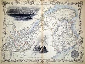
East Canada and New Brunswick, antique map with vignette views
Verlag: John Tallis & Co., London, 1854
Anbieter: Antipodean Books, Maps & Prints, ABAA, Garrison, NY, USA
Verbandsmitglied: ABAA ANZAAB ESA ILAB
Bewertung:
Maps. Map of New Brunswick and a portion of Quebec extending east to Montreal. Steel engraved map from the famous Victorian publisher John Tallis, well-known for the attractive vignette views surrounding the maps, which illustrate the peoples & customs of that region. 10 x 13 1/2" plus margins. Attractive decorative border around edge, period outline color, very good condition.
-
Chili and La Plata, antique map with vignette views
Verlag: John Tallis & Co., London, 1854
Anbieter: Antipodean Books, Maps & Prints, ABAA, Garrison, NY, USA
Verbandsmitglied: ABAA ANZAAB ESA ILAB
Bewertung:
Maps. Map of Chile with vignettes of travelling post, the Gobernador, the Grand Square of Buenos Ayres, Water Seller of Buenos Ayres and Rattlesnake. Steel engraved map from the famous Victorian publisher John Tallis, well-known for the attractive vignette views surrounding the maps, which illustrate the peoples & customs of that region. 10 x 13 1/2" plus margins. Attractive decorative border around edge, period outline color, very good condition.
-
Venezuela, New Granada, Equador, and The Guayanas, antique map with vignette views
Verlag: John Tallis & Co., London, 1854
Anbieter: Antipodean Books, Maps & Prints, ABAA, Garrison, NY, USA
Verbandsmitglied: ABAA ANZAAB ESA ILAB
Bewertung:
Maps. Steel engraved map from the famous Victorian publisher John Tallis, well-known for the attractive vignette views surrounding the maps, which illustrate the peoples & customs of that region. 10 x 13 1/2" plus margins. Attractive decorative border around edge, period outline color, very good condition.
-
France, antique map with vignette views
Verlag: John Tallis & Co., London, 1854
Anbieter: Antipodean Books, Maps & Prints, ABAA, Garrison, NY, USA
Verbandsmitglied: ABAA ANZAAB ESA ILAB
Bewertung:
Maps. Steel engraved map from the famous Victorian publisher John Tallis, well-known for the attractive vignette views surrounding the maps, which illustrate the peoples & customs of the region. 12 1/2 x 10" plus margins. Attractive decorative border around edge, period outline color, dusty on vignettes, o/w good condition.
-
Cabool, the Punjab and Beloochistan, antique map with vignette views
Verlag: John Tallis & Co., London, 1854
Anbieter: Antipodean Books, Maps & Prints, ABAA, Garrison, NY, USA
Verbandsmitglied: ABAA ANZAAB ESA ILAB
Bewertung:
Maps. Map of modern Afghanistan, Pakistan, and a portion of North-West India. Steel engraved map from the famous Victorian publisher John Tallis, well-known for the attractive vignette views surrounding the maps, which illustrate the peoples & customs of that region. 10 x 13 1/2" plus margins. Attractive decorative border around edge, period outline color, very good condition.
-
Northern Italy, antique map with vignette views
Verlag: John Tallis & Co., London, 1854
Anbieter: Antipodean Books, Maps & Prints, ABAA, Garrison, NY, USA
Verbandsmitglied: ABAA ANZAAB ESA ILAB
Bewertung:
Maps. Map of Northern Italy ending in Naples and including Corsica. Steel engraved map from the famous Victorian publisher John Tallis, well-known for the attractive vignette views surrounding the maps, which illustrate the peoples & customs of that region. 10 x 13 1/2" plus margins. Attractive decorative border around edge, period outline color, very good condition.
-
France, antique map with vignette views
Verlag: John Tallis & Co., London, 1854
Anbieter: Antipodean Books, Maps & Prints, ABAA, Garrison, NY, USA
Verbandsmitglied: ABAA ANZAAB ESA ILAB
Bewertung:
Maps. Steel engraved map from the famous Victorian publisher John Tallis, well-known for the attractive vignette views surrounding the maps, which illustrate the peoples & customs of the region. 12 1/2 x 10" plus margins. Attractive decorative border around edge, period outline color, sml. split at bottom of fold, o/w very good condition.
-
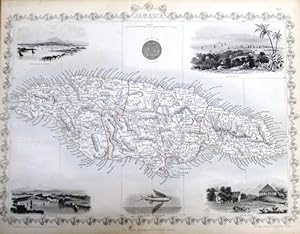
steal engraving / Grenzcolorierter Stahlstich Jamaica. Mit 6 weiteren BildStahlstichen 1) Port Royal Harbour. 2) Seal of the Colony. 3) Kingston. 4) Port Antonio. 5) Fliegender Fisch. 6) Sugar Mill.
Verlag: The London Printing and Publishing Company. o.J. [ca 1850], 1850
Erstausgabe
Softcover. Blattgröße 27x36 cm, Stichgröße 22 x 32 cm, mittig längs gefaltet. Die Tafel mit floraler Rahmung, eingezeichneten Längen- und Breitengraden und Maßstabsangabe. Das Blatt an den Rändern und in der Querfalte leicht lichtrandig sonst schönes Exemplar. --- In english language. Good condition. Die Tafel beschriftet mit der Ziffer 80. Wahrscheinlich die entsprechende Tafel aus dem Werk John Tallis: illustrated atlas and modern history of the world. -- Zu dekorativen Zwecken, zum Rahmen geeignet. Weitere Karten aus dem gleichen Werk vorhanden. "John Rapkin was a mapmaker who was concerned with the aesthetic value of his work as well as cartographic content. His fine maps are distinguished by the trademark decorative borders, vignettes and title displays. Rapkin worked in close association with the equally respected publisher John Tallis. The publishing rights of many of the maps passed to The London Printing and Publishing Company circa 1850. " -- Bitte Portokosten außerhalb EU erfragen! / Please ask for postage costs outside EU! / S ' il vous plait demander des frais de port en dehors de l ' UE! -- Genießen Sie den Sommer und bestellen Sie was zum Lesen! GM25-502032.
-
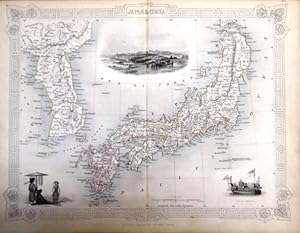
steal engraving / Grenzcolorierter Stahlstich Japan & Corea. Mit 2 Textseite 313/314. und mit weiteren drei BildStahlstichen 1) Coreans. 2) Yedo. 3) State Barge.
Verlag: The London Printing and Publishing Company. o.J. [ca 1850], 1850
Erstausgabe
Softcover. Blattgröße 27x36 cm, Kartengröße 22 x 29,5 cm, mittig längs gefaltet. Die Tafel mit floraler Rahmung, eingezeichneten Längen- und Breitengraden, Maßstabsangabe. Rückseitig Textseiten 313 und 314 zu Japan (zweispaltig). Das Blatt an den Rändern und in der Querfalte leicht lichtrandig. Das zweiseitige Textblatt zur Hälfte an der Karte klebend, mit leichtem Papierverlust im inneren Seitenbereich. Auf den Textseiten alphabetisch der Buchstabe J mit u.a.: January, Janus, Japan. Jar -Erklärungen. Gutes Exemplar. --- In english language. Good condition. Die Tafel beschriftet mit der Ziffer 45. Wahrscheinlich die entsprechende Tafel aus dem Werk von John Tallis: Illustrated atlas and modern history of the world.-- Zu dekorativen Zwecken, zum Rahmen geeignet. Weitere Karten aus dem gleichen Werk vorhanden. "John Rapkin was a mapmaker who was concerned with the aesthetic value of his work as well as cartographic content. His fine maps are distinguished by the trademark decorative borders, vignettes and title displays. Rapkin worked in close association with the equally respected publisher John Tallis. The publishing rights of many of the maps passed to The London Printing and Publishing Company circa 1850. " -- Bitte Portokosten außerhalb EU erfragen! / Please ask for postage costs outside EU! / S ' il vous plait demander des frais de port en dehors de l ' UE! -- Genießen Sie den Sommer und bestellen Sie was zum Lesen! Laden3.
-
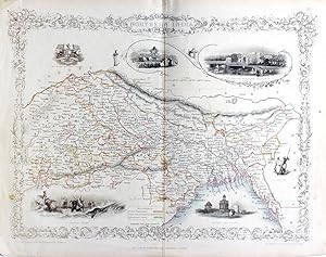
Northern India, antique map with vignette views
Verlag: John Tallis & Co., London, 1854
Anbieter: Antipodean Books, Maps & Prints, ABAA, Garrison, NY, USA
Verbandsmitglied: ABAA ANZAAB ESA ILAB
Bewertung:
Maps. Steel engraved map from the famous Victorian publisher John Tallis, well-known for the attractive vignette views surrounding the maps, which illustrate the peoples & customs of that region. 10 x 13 1/2" plus margins. Attractive decorative border around edge, very good condition.
-
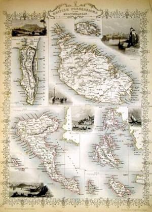
British Possessions in the Mediterranean, antique map with vignette views
Verlag: John Tallis & Co., London, 1854
Anbieter: Antipodean Books, Maps & Prints, ABAA, Garrison, NY, USA
Verbandsmitglied: ABAA ANZAAB ESA ILAB
Bewertung:
Maps. Map of Britain's possessions in the Mediterranean including Gibraltar, Malta, Corfu, and others. Steel engraved map from the famous Victorian publisher John Tallis, well-known for the attractive vignette views surrounding the maps, which illustrate the peoples & customs of that region. 10 x 13 1/2" plus margins. Attractive decorative border around edge, period outline color, very good condition.
-
Northern India, antique map with vignette views
Verlag: John Tallis & Co., London, 1854
Anbieter: Antipodean Books, Maps & Prints, ABAA, Garrison, NY, USA
Verbandsmitglied: ABAA ANZAAB ESA ILAB
Bewertung:
Maps. Steel engraved map from the famous Victorian publisher John Tallis, well-known for the attractive vignette views surrounding the maps, which illustrate the peoples & customs of that region. 10 x 13 1/2" plus margins. Attractive decorative border around edge, period outline color, slightly foxed, o/w good condition.
-
![Bild des Verkäufers für [Map] Baltic Sea zum Verkauf von Kaaterskill Books, ABAA/ILAB](https://pictures.abebooks.com/inventory/md/md30661485703.jpg)
[Map] Baltic Sea
Verlag: London Printing and Publishing Company, London, 1853
Anbieter: Kaaterskill Books, ABAA/ILAB, East Jewett, NY, USA
Verbandsmitglied: ABAA ILAB IOBA
Bewertung:

1 sheet, folded. 27 x 37 .5 cm. Engraved map, outlined in color, with five engraved vignettes. 27 x 37.5 cm. Contains decorated border. Illustrations drawn & engraved by H. Winkles, and depict Kronstadt, Revel, St. Petersburg, Abo, and Helsingfors. Taken from Tallis' "Illustrated Atlas and Modern History of the World" or "The Illustrated War with Russia", after he formed a partnership with Ephraim Tipton Brain in 1853, as the London Publishing Company. Very good, edge worn, few marginal tears, faint soiling.
-
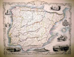
Spain and Portugal, antique map with vignette views
Verlag: John Tallis & Co., London, 1854
Anbieter: Antipodean Books, Maps & Prints, ABAA, Garrison, NY, USA
Verbandsmitglied: ABAA ANZAAB ESA ILAB
Bewertung:
Maps. Steel engraved map from the famous Victorian publisher John Tallis, well-known for the attractive vignette views surrounding the maps, which illustrate the peoples & customs of that region. 10 x 13 1/2" plus margins. Attractive decorative border around edge, period outline color, dusty at top margin, o/w good condition.
-
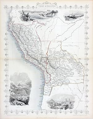
Peru & Bolivia, antique map with vignette views
Verlag: John Tallis & Co., London, 1854
Anbieter: Antipodean Books, Maps & Prints, ABAA, Garrison, NY, USA
Verbandsmitglied: ABAA ANZAAB ESA ILAB
Bewertung:
Maps. Steel engraved map from the famous Victorian publisher John Tallis, well-known for the attractive vignette views surrounding the maps, which illustrate the peoples & customs of the region. 10 x 12 1/2" plus margins. Attractive decorative border around edge, period outline color, very good condition.
