Gesamtpreis (1 Artikel Artikel):
Versandziel:

quad matthias (80 Ergebnisse)
Direkt zu den wichtigsten Suchergebnissen
Suchfilter
Produktart
- Alle Product Types
- Bücher (53)
- Magazine & Zeitschriften (Keine weiteren Ergebnisse entsprechen dieser Verfeinerung)
- Comics (Keine weiteren Ergebnisse entsprechen dieser Verfeinerung)
- Noten (Keine weiteren Ergebnisse entsprechen dieser Verfeinerung)
- Kunst, Grafik & Poster (3)
- Fotografien (Keine weiteren Ergebnisse entsprechen dieser Verfeinerung)
- Karten (24)
- Manuskripte & Papierantiquitäten (Keine weiteren Ergebnisse entsprechen dieser Verfeinerung)
Zustand Mehr dazu
- Neu (6)
- Wie Neu, Sehr Gut oder Gut Bis Sehr Gut (7)
- Gut oder Befriedigend (15)
- Ausreichend oder Schlecht (Keine weiteren Ergebnisse entsprechen dieser Verfeinerung)
- Wie beschrieben (52)
Einband
Weitere Eigenschaften
- Erstausgabe (2)
- Signiert (Keine weiteren Ergebnisse entsprechen dieser Verfeinerung)
- Schutzumschlag (2)
- Angebotsfoto (71)
Sprache (3)
Gratisversand
Land des Verkäufers
Verkäuferbewertung
-

Die Jahr Blum Welch Da Begreifft Ud in Sich Helt Fast Alle Iahren Dieser Welt Namhafft Persone, Stedt und Lant Hieraus Dir Werden mit Bekant In Reime Weis VIL Mercklich Thaten und Geschicht
Anbieter: PBShop.store US, Wood Dale, IL, USA
Verkäuferbewertung 5 von 5 Sternen

PAP. Zustand: New. New Book. Shipped from UK. Established seller since 2000.
-
Die Jahr Blum Welch Da Begreifft Ud in Sich Helt Fast Alle Iahren Dieser Welt Namhafft Persone, Stedt und Lant Hieraus Dir Werden mit Bekant In Reime Weis VIL Mercklich Thaten und Geschicht
Anbieter: PBShop.store UK, Fairford, GLOS, Vereinigtes Königreich
Verkäuferbewertung 5 von 5 Sternen
EUR 16,89
EUR 3,75 für den Versand von Vereinigtes Königreich nach USAAnzahl: 15 verfügbar
In den WarenkorbPAP. Zustand: New. New Book. Shipped from UK. Established seller since 2000.
-

Die Jahr Blum Welch Da Begreifft Ud in Sich Helt Fast Alle Iahren Dieser Welt Namhafft Persone, Stedt und Lant Hieraus Dir Werden mit Bekant In Reime Weis VIL Mercklich Thaten und Geschicht
Anbieter: PBShop.store US, Wood Dale, IL, USA
Verkäuferbewertung 5 von 5 Sternen
HRD. Zustand: New. New Book. Shipped from UK. Established seller since 2000.
-
Die Jahr Blum Welch Da Begreifft Ud in Sich Helt Fast Alle Iahren Dieser Welt Namhafft Persone, Stedt und Lant Hieraus Dir Werden mit Bekant In Reime Weis VIL Mercklich Thaten und Geschicht
Anbieter: PBShop.store UK, Fairford, GLOS, Vereinigtes Königreich
Verkäuferbewertung 5 von 5 Sternen
EUR 21,50
EUR 4,74 für den Versand von Vereinigtes Königreich nach USAAnzahl: 15 verfügbar
In den WarenkorbHRD. Zustand: New. New Book. Shipped from UK. Established seller since 2000.
-

Geographisch Handtbuch : Cologne 1600
Verlag: Theatrum Orbis Terrarum, Amsterdam, 1969
Sprache: Englisch
Hardcover. Zustand: Very Good. 4to (28 cm), XIXXX pp, 2 ff, 82 folding maps. Publisher's cloth with dust jacket (ex-library copy, but clean and firm, without stamps or marks, two bookplates, dj rubbed at extremities and slightly stained). Matthias Quad (1557-1613) was an engraver and cartographer who worked in Cologne. This volume is a facsimile of his Geographisches Handtbuch, an atlas in quarto originally published in 1599. The introduction by Wilhelm Bonacker includes a biography of Quad, detailed descriptions of the various editions of the Geographisches Handtbuch, and a bibliography of Quad's other works.
-

Die Jahr Blum
Anbieter: buchversandmimpf2000, Emtmannsberg, BAYE, Deutschland
Verkäuferbewertung 5 von 5 Sternen
Taschenbuch. Zustand: Neu. Neuware -Die Jahr Blum - Ein kurzer Auszug und Begriff aus vielerlei Jüdischen, Griechischen, Römischen und Deutschen Scripten ist ein unveränderter, hochwertiger Nachdruck der Originalausgabe aus dem Jahr 1595.Hans Elektronisches Buch ist Herausgeber von Literatur zu unterschiedlichen Themengebieten wie Forschung und Wissenschaft, Reisen und Expeditionen, Kochen und Ernährung, Medizin und weiteren Genres. Der Schwerpunkt des Verlages liegt auf dem Erhalt historischer Literatur. Viele Werke historischer Schriftsteller und Wissenschaftler sind heute nur noch als Antiquitäten erhältlich. Hans Elektronisches Buch verlegt diese Bücher neu und trägt damit zum Erhalt selten gewordener Literatur und historischem Wissen auch für die Zukunft bei.Books on Demand GmbH, Überseering 33, 22297 Hamburg 84 pp. Deutsch.
-

Taschenbuch. Zustand: Neu. Die Jahr Blum | Ein kurzer Auszug und Begriff aus vielerlei Jüdischen, Griechischen, Römischen und Deutschen Scripten | Matthias Quad | Taschenbuch | 84 S. | Deutsch | 2017 | hansebooks | EAN 9783743680661 | Verantwortliche Person für die EU: Hansebooks GmbH, Trakehner Weg 52, 22844 Norderstedt, gb[at]hansebooks[dot]com | Anbieter: preigu.
-

Geographisch Handtbuch, Cologne 1600
Verlag: Nico Israel
Anbieter: Powell's Bookstores Chicago, ABAA, Chicago, IL, USA
Verkäuferbewertung 5 von 5 Sternen
Zustand: Used - Like New. 1969. Theatrum Orbis Terrarum. Cloth, dj., small quarto, unpaginated facsimile. Some light scuffing to dj. Otherwise in excellent condition. Fine.
-
Zustand: Good. Gilt hardcover, (full-page) b/w maps; With an introduction by Wilhelm Bonacker. Text in German and English.; Some tobacco smell; book plate on verso front cover, no dust jacket.
-
Geographisch Handtbuch: Cologne 1600
Verlag: Theatrum Orbis Terrarum, Netherlands, 1969
Anbieter: Rooke Books PBFA, Bath, Vereinigtes Königreich
Verbandsmitglied: PBFA
Verkäuferbewertung 5 von 5 Sternen
EUR 140,71
EUR 17,06 für den Versand von Vereinigtes Königreich nach USAAnzahl: 1 verfügbar
In den WarenkorbCloth. Zustand: Fine. Zustand des Schutzumschlags: Near Fine. Not Stated (illustrator). A very smart facsimile of the first world atlas produced by a German author, with the original dust wrapper. Main body of the text is written in German, with some English sections of the introduction. Facsimile of the first German edition of this world atlas, now thought to have been published before the first Latin edition. Illustrated throughout. The first atlas produced by a German author, with maps mainly based on Ortelius with their own charm and delicacy of execution. Some are decorated with reigning monarchs, with six relating to America. Original maps drawn by Johan Bussemacher, a German engraver, publisher, printer, and art dealer based in Cologne. Written by Matthias Quad, an engraver and cartographer from Cologne who was the first European mapmaker to use dotted lines to indicate international borders. With an introduction by Wilhelm Bonacker, a German cartographer and map-historian. In the original full cloth binding. Externally, excellent. Original unclipped dust wrapper is very smart with the odd small mark to the panels. Internally, firmly bound. Pages are very bright and clean throughout. A plain sticker to the front free endpaper. Fine. book.
-
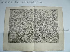
NIEDERSACHSEN & SACHSEN-ANHALT: BRAUNSCHWICK DUCATUS, HILDESHEIM
Verlag: Quad Matthias, 1557-1613, 1613
Anbieter: Hammelburger Antiquariat, Hammelburg, Deutschland
Verkäuferbewertung 5 von 5 Sternen
Hardcover. Zustand: very good. NIEDERSACHSEN & SACHSEN-ANHALT: BRAUNSCHWICK DUCATUS, HILDESHEIM EPISCOP: HALBERSTAT EPISOP: Author: Mathias QUAD (15571613) Place and Year: 1608 Technique: Copper engraving (tiny tears in white margins, slightly age-toned, otherwise in a good condition), sheet: 36 cm x 27,5 cm Highly decorative copper engraved map shows Lower Saxony and Saxony-Anhalt. The map was published in an atlas 'Fasciculus Geographicus' by Matthias Quad (1557 - 1613). Quad was born in the Dutch city of Deventer, where Jacob Roelofs spent his youth. In the 1580 Quad moved to Cologne. The city accepted many political and religious refugees, like Roelofs van Deventer himself some years before. At the same time Frans Hogenberg was active in Cologne too. At the end of the 16th century this city was one of the publishing centres of Europe. Most of the Quad's small format atlases were printed in this time in Cologne. In the time of twelve years he produced 18 geographical-historical books. Because of his controversial religious believes he had to leave Cologne in 1604. After moving around Germany for nine years he died in Eppingen (Baden-Wurttemberg) in 1613. Schöne detaillierte Karte von Niedersachsen und Sachsen-Anhalt mit Hildesheim, Braunschweig und Halberstadt. Aus 'Fasciculus Geographicus'. Gering gebräunt, kleine Risse im Rand, insgesamt gut erhalten. Verso Text.
-
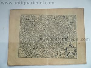
Bayern, anno 1596, Quad/Bussemacher, Karte
Verlag: Quad Matthias, 1557-1613, 1613
Anbieter: Hammelburger Antiquariat, Hammelburg, Deutschland
Verkäuferbewertung 5 von 5 Sternen
Hardcover. Zustand: very good. Bayern, anno 1596, Quad/Bussemacher, Karte BAYERN BAVARIA, GERMANY: BAVARIA DUCATUS. Author: Mathias QUAD (15571613) - Johann BUSSEMACHER (fl. c.1580 1613) Place and Year: Cologne, [1596]. Technique: Kupferstich Copper engraving (Very Good, slightly age-toned), 26,5 x 36 cm (10,4 x 14,2 inches). Detailed map shows Bavaria in Germany. The map was engraved by Johann Bussemacher and published in an atlas 'Fasciculus Geographicus' by Matthias Quad (1557 - 1613). Quad was born in the Dutch city of Deventer, where Jacob Roelofs spent his youth. In the 1580 Quad moved to Cologne. The city accepted many political and religious refugees, like Roelofs van Deventer himself some years before. At the same time Frans Hogenberg was active in Cologne too. At the end of the 16th century this city was one of the publishing centres of Europe. Most of the Quad's small format atlases were printed in this time in Cologne. In the time of twelve years he produced 18 geographical-historical books. Because of his controversial religious believes he had to leave Cologne in 1604. After moving around Germany for nine years he died in Eppingen (Baden-Wurttemberg) in 1613.
-
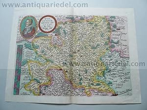
Wirtenbergensis, anno 1600, Quad
Verlag: Quad Matthias, 1557-1613, 1613
Anbieter: Hammelburger Antiquariat, Hammelburg, Deutschland
Verkäuferbewertung 5 von 5 Sternen
Hardcover. Zustand: very good. "WIRTENBERGENSIS DVCATVS Auctore Georgio Gadnero.", flächenkolorierte Kupferkarte von Quad M., bei Bussemacher, lat. Rückentext, anno 1600. Zeigt das Gebiet zwischen Schwäbisch Hall, Ulm, Bad Herrenalb , Stuttgart im Zentrum der Karte. Blatt: 27x35 cm.
-
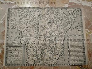
Abyssinorum, map, anno 1600, Bussemacher/Quad, scarce
Verlag: Quad Matthias, 1557-1613, 1613
Anbieter: Hammelburger Antiquariat, Hammelburg, Deutschland
Verkäuferbewertung 5 von 5 Sternen
Hardcover. Zustand: very good. Coppermap, edited Quad/Bussemacher, anno 1600, size: 21x29 cm.
-

KLEINE BETTLEKTÜRE FÜR JECKE KÖLNER. Leckerbissen für Kölsche und Imis
Anbieter: HPI, Inhaber Uwe Hammermüller, Herzebrock-Clarholz, Deutschland
Verkäuferbewertung 1 von 5 Sternen

Hardcover. Zustand: Gut. Eine Sammlung humorvoller und kultureller Geschichten über Köln und seine einzigartige Karnevalskultur. Zustand: Einband mit stärkeren Gebrauchsspuren, Seiten geringfügig gebräunt, insgesamt GUTER Zustand. Stichworte: Genres: Humor, Lokalgeschichte, Kurzgeschichten; Schlagworte: Köln, Jecken, Humor, Geschichten, Deutschland, Rheinland, Karneval, Kultur, Kölner, Karnevalskultur. 123 Deutsch 148g.
-
KLEINE BETTLEKTÜRE FÜR JECKE KÖLNER. Leckerbissen für Kölsche und Imis
Anbieter: Butterfly Books GmbH & Co. KG, Herzebrock-Clarholz, Deutschland
Verkäuferbewertung 5 von 5 Sternen
SonderangebotEUR 4,05
EUR 500,00 für den Versand von Deutschland nach USAAnzahl: 1 verfügbar
In den WarenkorbHardcover. Zustand: Gut. Eine Sammlung humorvoller und kultureller Geschichten über Köln und seine einzigartige Karnevalskultur. Zustand: Einband mit stärkeren Gebrauchsspuren, Seiten geringfügig gebräunt, insgesamt GUTER Zustand. Stichworte: Genres: Humor, Lokalgeschichte, Kurzgeschichten; Schlagworte: Köln, Jecken, Humor, Geschichten, Deutschland, Rheinland, Karneval, Kultur, Kölner, Karnevalskultur. 123 Deutsch 148g.
-

Bavaria Ducatus
Verlag: Lambert Andreas, Cologne, 1594
Anbieter: Clive A. Burden Ltd., Chalfont St. Giles, BUCKS, Vereinigtes Königreich
Verkäuferbewertung 5 von 5 Sternen
Karte
EUR 87,94
EUR 25,22 für den Versand von Vereinigtes Königreich nach USAAnzahl: 1 verfügbar
In den WarenkorbNo binding. 195 x 290 mm., in good condition. A fine example of the Matthias Quad map of Bavaria, Germany, engraved by Johann Bussemacher. It was published in 'Europae Totius Orbis Terrarum' in 1594 and orientated with north at the top. It extends from Augsburg in the west to Passaw in the east. The city of Augsburg in the south east is also depicted. Meurer "Atlantes Colonienses" Qua 4 no. 15.
-

Palatinatus Bavariae
Verlag: Cologne, 1600
Anbieter: Clive A. Burden Ltd., Chalfont St. Giles, BUCKS, Vereinigtes Königreich
Verkäuferbewertung 5 von 5 Sternen
Karte
EUR 87,94
EUR 25,22 für den Versand von Vereinigtes Königreich nach USAAnzahl: 1 verfügbar
In den WarenkorbNo binding. 195 x 290 mm., in good condition. A fine example of the Matthias Quad map of Bavaria, Germany, engraved by Johann Bussemacher. It was published in 'Geographisch Handtbuch' in 1600 and orientated with north at the top. It is on a good scale extending from Nurnberg in the west to Ingolstatt and Regensburgh in the south. Meurer 'Atlantes Colonienses' Qua 6 no. 26.
-
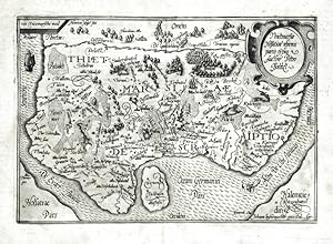
Thietmarsiae Holsatiae regionis partis typus
Verlag: Johann Bussemacher, Köln, 1596
Anbieter: Antikvariat Krenek, Prag, Tschechien
Verbandsmitglied: ILAB
Verkäuferbewertung 5 von 5 Sternen
Karte
Kein Einband. Zustand: Sehr gut. Kreis Dithmarschen. "Thietmarsiae Holsatiae regionis partis typus". Orig. Kupferstich Karte nach P. Böckel von M. Quad. Bei J. Bussemacher in Köln, 1597.Mit ornament. Titelkart., Meilenzeiger oben links und kl. Schiff darunter. 18,5:26,5 cm auf breitrandigem Papier. Ostorientierte Karte von Elbemündung von Brunsbüttel bis in die Nordsee.
-
"Sclavonia, Croatia, Bosnia & Dalmatiae Pars Maior. Johan bussemecher excudit". Aus Matthias Quad: Geographisch Handtbuch.
Verlag: Köln, Quad, 1600., 1600
Anbieter: Antiquariat MEINDL & SULZMANN OG, Wien - Vienna, Österreich
Verkäuferbewertung 5 von 5 Sternen
Blattgröße ca. 24,5 x 32 cm. Bildausschnitt ca. 18 x 28 cm. Rückseite mit deutschem Text: ". Es seindt zwischen dem Venedischen Meer und Ungerlandt zwo namhaffte Prouintzen gelegen, die man Illyricum unnd Dalmatiam hat geheissen . Nach etlicher sag, so ist Croatia vorzeiten Lyburnia gewesen . Die Völcker dieses Lands seind ein zeitlang gar grober sitten gewesen, und haben auff dem Meer geschifft unnd geraubt.". Matthias Quad von Kinckelbach (1557-1613) war historisch-geographischer Schriftsteller, Kupferstecher und Schulmeister. Er lebte von 1587 bis 1604 in Köln. Im Jahr 1592 entstand hier sein erstes schriftstellerisches Werk, eine Art Atlas, bei dem der Text auf den Rückseiten der Karten gedruckt wurde. In einem Zeitraum von nur zwölf Jahren, von 1592 bis Ende 1604, verfasste Quad 18 historisch-geographische Schriften. Diese Werke wurden fast sämtlich in Köln verlegt, meist bei Johann Bussemacher und Wilhelm Lützenkirchen.- Papier tlw. etw. gebräunt. Der Rückenfalz im unteren Rand tlw. restauriert.
-
Portugalliae que olim Lusitania, novissima et exactissima descriptio. 1590
Verlag: Johann Bussemacher, Köln, 1594
Anbieter: Antikvariat Krenek, Prag, Tschechien
Verbandsmitglied: ILAB
Verkäuferbewertung 5 von 5 Sternen
Karte
Kein Einband. Zustand: Gut bis sehr gut. Portugal. "Portugalliae que olim Lusitania, novissima et exactissima descriptio. 1590". Orig. copperplate engraving, M. Quad after V. A. Secco's map of Portugal. Published by J. Bussemacher, Köln, 1594. With ornamental cartouche, coat-of-arms, 2 ships and a sea-monster. 18,5:26,5 cm (7 1/4 x 10 3/4 inch.). A very decorative map of Portugal. Oriented to the West.
-
Elsatia Superior, Ober Elsas
Verlag: Cologne, 1600
Anbieter: Clive A. Burden Ltd., Chalfont St. Giles, BUCKS, Vereinigtes Königreich
Verkäuferbewertung 5 von 5 Sternen
Karte
EUR 164,16
EUR 25,22 für den Versand von Vereinigtes Königreich nach USAAnzahl: 1 verfügbar
In den WarenkorbNo binding. 200 x 270 mm., with old colour, light soiling to margin otherwise in good condition. An early map of the region of Alsace oriented to the west showing both sides of the upper Rhine River between Basel and Lahr. Engraved by Johann Bussemacher it is from Quad's 'Geographisch Handtbuch'. Meurer, P.H. (Cologne) Qua 16.
-

NAMURCUM, CUM, ADJACENTIBUS REGIONIBUS DESCR NAMEN.
Verlag: Fascilus Geographicus. 1608, 1608
Anbieter: Peter Harrington. ABA/ ILAB., London, Vereinigtes Königreich
Verbandsmitglied: ABA ILAB PBFA
Verkäuferbewertung 5 von 5 Sternen
EUR 170,02
EUR 25,05 für den Versand von Vereinigtes Königreich nach USAAnzahl: 1 verfügbar
In den WarenkorbMap of part of Belgium and Luxembourg. North is to the left. Matthaus Quad was a German cartographer based in Cologne, which, at the time was the centre for German cartography. This map is from his Fascilus Geographicus. It was printed by Johannes Bussemacher. Copper engraving. Overall good condition. Some show through from reverse. Original colour. Size: 27 x 19.5 cm. (10˝ x 7˝ inches).
-

FLORENTISSIMUS RHENI PALATINATUS. 32.
Verlag: Fascilus Geographicus. 1608, 1608
Anbieter: Peter Harrington. ABA/ ILAB., London, Vereinigtes Königreich
Verbandsmitglied: ABA ILAB PBFA
Verkäuferbewertung 5 von 5 Sternen
EUR 170,02
EUR 25,05 für den Versand von Vereinigtes Königreich nach USAAnzahl: 1 verfügbar
In den WarenkorbA curious map of the Rheinland and Hessen regions of Germany. East appears to be to the right of the map, and west to the left, so Frankfurt for example is shown to the left of Meintz, and Bingen on the right when in fact they should be the other way round. Matthaus Quad was a German cartographer based in Cologne, which, at the time was the centre for German cartography. This map is from his Fascilus Geographicus. It was printed by Johannes Bussemacher. Copper engraving. Overall good condition. Some show through from reverse, and old repair to top margin. Original colour. Size: 27 x 21 cm. (10˝ x 8˝ inches).
-

THURINGIA. 32.
Verlag: Fascilus Geographicus. 1608, 1608
Anbieter: Peter Harrington. ABA/ ILAB., London, Vereinigtes Königreich
Verbandsmitglied: ABA ILAB PBFA
Verkäuferbewertung 5 von 5 Sternen
EUR 170,02
EUR 25,05 für den Versand von Vereinigtes Königreich nach USAAnzahl: 1 verfügbar
In den WarenkorbMap of the Free State of Thuringia, located in central Germany. Considered one of the smallest of Germany's sixteen Bundesländer (federal states). The lion insignia from the state flag is shown in reverse on the right. Matthaus Quad was a German cartographer based in Cologne, which, at the time was the centre for German cartography. This map is from his Fascilus Geographicus. It was printed by Johannes Bussemacher. Copper engraving. Overall good condition. Some show through from reverse. Original colour. Size: 27 x 21 cm. (10˝ x 8˝ inches).
-

BRAUNSWICK DUCATUS. HILDESHEIM EPISCOP: & HALBERSTAT EPISCOP:
Verlag: Frankfurt. 1608, 1608
Anbieter: Peter Harrington. ABA/ ILAB., London, Vereinigtes Königreich
Verbandsmitglied: ABA ILAB PBFA
Verkäuferbewertung 5 von 5 Sternen
EUR 170,02
EUR 25,05 für den Versand von Vereinigtes Königreich nach USAAnzahl: 1 verfügbar
In den WarenkorbHandsome map of part of central Germany. Title cartouche at left centre. Matthaus Quad was a German cartographer based in Cologne, which, at the time was the centre for German cartography. This map is from his Fascilus Geographicus. It was printed by Johannes Bussemacher. Copper engraving. Very good condition. Good margins. Rivers, forests and a few place-names outlined in brown and green. Original outline colour. Size: 30 x 21 cm.
-

MISNIAE ET LUSATIAE TABULA.
Verlag: Fascilus Geographicus. 1608, 1608
Anbieter: Peter Harrington. ABA/ ILAB., London, Vereinigtes Königreich
Verbandsmitglied: ABA ILAB PBFA
Verkäuferbewertung 5 von 5 Sternen
EUR 170,02
EUR 25,05 für den Versand von Vereinigtes Königreich nach USAAnzahl: 1 verfügbar
In den WarenkorbHandsome map of part of south-western Germany centred on Dresden.Title cartouche at top left. Matthaus Quad was a German cartographer based in Cologne, which, at the time was the centre for German cartography. This map is from his Fascilus Geographicus. It was printed by Johannes Bussemacher. Copper engraving. Very good condition. Good margins. Rivers, forests and a few place-names outlined in brown and green. Original outline colour. Size: 27.5 x 19 cm. (11 x 7˝ inches).
-

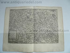
Waldeck Comitatus.
Verlag: Köln: Bussemecher um ,, 1592
Anbieter: Antiquariat Ruthild Jäger, Lueneburg, Deutschland
Verkäuferbewertung 4 von 5 Sternen

Kunst / Grafik / Poster
Kupferstichkarte, 27 x 19,5cm. Breitrandig. (wohl aus: M. Quad: Europae totius orbis terrarum desycriptio. Köln: Bussemecher 1592). * Dekorative Karte der Grafschaft Waldeck mit dem Gebiet bis Meschede, Brilon, Warburg, Fritzlar, Wildungen, Schmalenberg; Rollwerkkartusche mit Wappen. Rückseitig deutsche Beschreibung der Grafschaft (Text leicht durchscheinend). Selten.
-

Saxonum regionis quatenus eius gentis imperium nomenque olim patebat, recens germanague delineatio, Christiano Schrotenio authore.
Verlag: Fascilus Geographicus. 1608, 1608
Anbieter: Peter Harrington. ABA/ ILAB., London, Vereinigtes Königreich
Verbandsmitglied: ABA ILAB PBFA
Verkäuferbewertung 5 von 5 Sternen
EUR 193,48
EUR 25,05 für den Versand von Vereinigtes Königreich nach USAAnzahl: 1 verfügbar
In den WarenkorbMap of north east Germany. Matthaus Quad was a German cartographer based in Cologne, which, at the time was the centre for German cartography. This map is from his Fascilus Geographicus. It was printed by Johannes Bussemacher. Copper engraving. Very good condition. Some show through from reverse. Some place-names, rivers and forests are highlighted in brown and green. Uncoloured. Size: 26.5 x 18 cm. (10˝ x 7 inches).