
Gesamtpreis (1 Artikel Artikel):
Versandziel:

philippe pretot etienne andre moithey (4 Ergebnisse)
Direkt zu den wichtigsten Suchergebnissen
Produktart
- Alle Produktarten
- Bücher (2)
- Magazine & Zeitschriften
- Comics
- Noten
- Kunst, Grafik & Poster
- Fotografien
- Karten (2)
-
Manuskripte &
Papierantiquitäten
Zustand
- Alle
- Neu
- Antiquarisch/Gebraucht
Einband
- alle Einbände
- Hardcover
- Softcover
Weitere Eigenschaften
- Erstausgabe
- Signiert
- Schutzumschlag
- Angebotsfoto (3)
Land des Verkäufers
Verkäuferbewertung
-
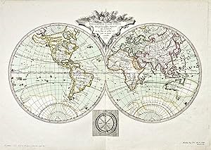
Indication Nautique des princip aux, espaces de l'Ocean." - World Map Mappenmonde Weltkarte Karte
Verlag: Paris, 1772
Anbieter: Antiquariat Steffen Völkel GmbH, Seubersdorf, Deutschland
Bewertung:

Karte
Seltene altkolorierte Kupferstich-Karte von E.A. Philippe de Pretot. -- Blatt-Maße: ca. 31 x 46 cm. -- gut erhalten. || Rare hand colored engraved map by E.A. Philippe de Pretot. -- in very good condition. Sprache: Französisch Gewicht in Gramm: 1550.
-

CZECH REPUBLIC: CHOROGRAPHIE DU ROYAUME DE BOHEME, DU DUCHE DE SILESIE, DES MARQUISATS DE MORAVIE ET DE LUSACE.
Anbieter: Antiquariat Dasa Pahor GbR, München, Deutschland
Bewertung:

Karte
Decorative map shows Bohemia, Silesia, Moravia and Lusatia, parts of today's Czech Republic, Poland and Germany. With decorative recent colour. This map was published in Philippe de Pretot' Atlas Universel pour l'Etude de la Geographie et de l'histoire Ancienne et Moderne in Paris in 1787. Philippe de Pretot was a French geographer and a mamber of Academies de Rouen and d'Angers.
-

L'ANGLETERRE
Verlag: Cosmographie Universale. 1787., 1787
Anbieter: Peter Harrington. ABA/ ILAB., London, Vereinigtes Königreich
Verbandsmitglied: ABA ILAB PBFA
Bewertung:
Detailed map of England with ornamental title cartouche and coats of arms. Copper engraving. Later colour. Fine condition. Light foxing to the margins, not affecting the image. Size: 41 x 28 cm. (16 x 11 inches).
-

CHOROGRAPHIE DU CERCLE DE SOUABE.
Verlag: Atlas Universal. 1787, 1787
Anbieter: Peter Harrington. ABA/ ILAB., London, Vereinigtes Königreich
Verbandsmitglied: ABA ILAB PBFA
Bewertung:
Map of south east Germany. Decorated cartouche at top right. 'Explication des Signes' and scales at lower left. Copper engraving. Later colour. Fine condition. Size: 34 x 26.5 cm. (13˝ x 10˝ inches).
