
Gesamtpreis (1 Artikel Artikel):
Versandziel:

mitchell samuel augustus young james (7 Ergebnisse)
Direkt zu den wichtigsten Suchergebnissen
Suchfilter
Produktart
- Alle Product Types
- B³cher (7)
- Magazine & Zeitschriften (Keine weiteren Ergebnisse entsprechen dieser Verfeinerung)
- Comics (Keine weiteren Ergebnisse entsprechen dieser Verfeinerung)
- Noten (Keine weiteren Ergebnisse entsprechen dieser Verfeinerung)
- Kunst, Grafik & Poster (Keine weiteren Ergebnisse entsprechen dieser Verfeinerung)
- Fotografien (Keine weiteren Ergebnisse entsprechen dieser Verfeinerung)
- Karten (Keine weiteren Ergebnisse entsprechen dieser Verfeinerung)
- Manuskripte & Papierantiquitõten (Keine weiteren Ergebnisse entsprechen dieser Verfeinerung)
Zustand Mehr dazu
- Neu (Keine weiteren Ergebnisse entsprechen dieser Verfeinerung)
- Wie Neu, Sehr Gut oder Gut Bis Sehr Gut (Keine weiteren Ergebnisse entsprechen dieser Verfeinerung)
- Gut oder Befriedigend (1)
- Ausreichend oder Schlecht (Keine weiteren Ergebnisse entsprechen dieser Verfeinerung)
- Wie beschrieben (6)
Einband
Weitere Eigenschaften
- Erstausgabe (1)
- Signiert (Keine weiteren Ergebnisse entsprechen dieser Verfeinerung)
- Schutzumschlag (Keine weiteren Ergebnisse entsprechen dieser Verfeinerung)
- Angebotsfoto (2)
Sprache (1)
Preis
- Beliebiger Preis
- Weniger als EUR 20 (Keine weiteren Ergebnisse entsprechen dieser Verfeinerung)
- EUR 20 bis EUR 45 (Keine weiteren Ergebnisse entsprechen dieser Verfeinerung)
- Mehr als EUR 45
Gratisversand
Land des Verkõufers
Verkõuferbewertung
-
Mitchell's Reference & Distance map of the United States.
Verlag: Philadelphia: Samuel Augustus Mitchell, 1848 (copyright 1833), 1848
Anbieter: Arader Galleries - AraderNYC, New York, NY, USA
Verkõuferbewertung 5 von 5 Sternen

Erstausgabe
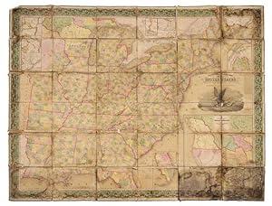
Unbound. 1st Edition. "Engraved folding wall map with large inset map of Texas, Oregon and California in lower right, several smaller inset maps of the Falls of Niagara, Northern Maine, Rochester, Albany, Washington, Charleston, and Florida on the perimeter (overall 56 x 71 in.; 142.5 x 179.6 cm), hand-colored in wash and outline, dissected in 36 sections and mounted on linen, engraving of an eagle on a seashell grasping an olive branch in his left talon and arrows in the right, flanked by the capitol at Washington and Philadelphia (attributed to William Mason), wide ornate vine border, green cloth selvage. BINDING/CONDITION: Marbled paper outer panels. Dampstained with traces of mold chiefly on the linen backing but occasionally affecting portions of the map, some sections separating from backing at corners, margins of several sections creased. (65B2C) FIRST PRINTING OF A LANDMARK MAP OF THE WEST AND THE FIRST TO INCLUDE AN INSET MAP OF TEXAS. This monumental wall map was produced by Mitchell the same year as his pocket size map of Texas, Oregon and California "[It is] an important map [depicting] the western political situation on the eve of the Mexican War. A composite map, it judiciously incorporated the recent work of Nicollet, Wilkes, Frķmont, and Emory. Both the Oregon Trail and the 'Caravan route to Santa Fe' are included" (Schwartz & Ehrenberg). Wheat adds: "This map represents a great step forward [utilizing] the recent explorations that had bounded and determined the nature of the Great Basin. The Texas claim to a western boundary up to the Rio Grande is here shown, with the northern panhandle extending all the way to the 42nd parallel, following Emory's map of Texas" (Wheat). PROVENANCE: Evelyn and Eric P. Newman (sale, Leslie Hindman, 12 November 2018, Lot 89) REFERENCES: Rumsey 4308.000; Schwartz & Eherenberg, The Mapping of America, p. 276; Wheat, Mapping of the Transmississippi (1959) II:35, no. 520 (referring to the pocket map's "Accompaniement")".
-

Mitchell's Traveller's Guide through the United States, Containing the Principal Cities, Towns, &c Alphabetically Arranged; Together with the Stage, Steam-Boat, Canal, and Rail-Road Routes, with the Distances, in Miles, from Place to Place.
Verlag: Philadelphia: Thomas, Cowperthwait & Co., [1845]., 1845
Anbieter: Arader Galleries - AraderNYC, New York, NY, USA
Verkõuferbewertung 5 von 5 Sternen
Hardcover. Folding engraved map (17 4/8 x 21 4/8 inches) showing the United States as far west as Indiana Territory, as far south as Florida with 8 insets of the Vicinity of Cincinnati; Vicinity of Albany; Vicinity of the Falls of Niagara; Vicinity of New York; Vicinity of Charleston; Vicinity of Baltimore and Washington; Vicinity of Philadelphia; and Vicinity of Boston, with original hand-colour in outline (very browned). 78-page guide. Original blind-embossed tan roan, lettered in gilt on upper cover. Provenance: Several canal routes through Ohio, Indiana, Pennsylvania, and New York shown in blue ink. First published in 1832, with accompanying text added in 1834, and continuously updated and enlarged. "Internal improvements coupled with the great Irish and German migrations beginning in 1827 led to the production of traveler's guides that depicted roads and their distances, steamboat and canal routes, and lengths of principal railroads. In 1832 Samuel Augustus Mitchell first issued his 'Traveller's Guide through the United States' and complimented it two years later with 'Tourist Pocket Maps' of the different states. These early works and their multitudinous progeny over the next fifty years laid the foundation for the road maps of today" (Schwartz & Ehrenberg, The Mapping of America, page 255).
-
Map of the States of Ohio, Indiana and Illinois with the Settled Part of Michigan.
Verlag: Philadelphia: S. Augustus Mitchell, 1835., 1835
Anbieter: Arader Galleries - AraderNYC, New York, NY, USA
Verkõuferbewertung 5 von 5 Sternen
Hardcover. Engraved folding pocket map (17 4/8 x 21 6/8 inches to the neat-line, full margins). Letterpress census laid down on the front past-down. Fine folding engraved map with insets of the "Lead Region East of the Mississippi River"; "Falls of Ohio"; "Vicinity of Cincinnati"; and "Vicinity of Detroit", with original hand-colour in full (some browing and short separations at folds). Contemporary publisher's red roan, gilt (scuffed). First issued in 1834, and with some changes from that issue: Lake Michigan has been redrawn, the addition of new counties in Indiana is notes, such as Porter, Newton, and Jasper, etc.). Iowa did not become a territory until 1838 and a state until 1844, and is labeled here as Missouri and Wisconsin Territory. Interestingly this map shows the controversial Dubuque lead mining region, including the site of Julien Dubuque's grave. Between 1796, when this grant was confirmed by the Spanish governor of Louisiana, and his death in 1810, Dubuque had succeeded in establishing a monopoly controlling the smelting and shipping of lead from the region, known as the "Mines of Spain". Unable to sustain a working relationship with the local Ioway Indians Dubuque's creditors who succeeded to his rights abandoned the enterprise, and lead-mining rights in Iowa remained in a legal turmoil that lasted until 1853, when the United States Supreme Court issued a landmark decision on the ownership of the Dubuque area mines, disallowing claims based on Julien Dubuque's Spanish land grants.
-
Map of the States of Ohio, Indiana and Illinois with the Settled Part of Michigan.
Verlag: Philadelphia: S. Augustus Mitchell, 1836., 1836
Anbieter: Arader Galleries - AraderNYC, New York, NY, USA
Verkõuferbewertung 5 von 5 Sternen
Hardcover. Engraved folding pocket map (17 4/8 x 22 2/8 inches to the neat-line, full margins). Letterpress census laid down on the front past-down. Fine folding engraved map with insets of the "Lead Region East of the Mississippi River"; "Falls of Ohio"; "Vicinity of Cincinnati"; and "Vicinity of Detroit", with original hand-colour in full (some spotting and offseting). Contemporary publisher's cherry roan, gilt (a bit rubbed). First issued in 1834, and with some changes from that issue: Lake Michigan has been redrawn, the addition of new counties in Indiana is notes, such as Porter, Newton, and Jasper, etc.). Iowa did not become a territory until 1838 and a state until 1844, and is labeled here as Missouri and Wisconsin Territory. Interestingly this map shows the controversial Dubuque lead mining region, including the site of Julien Dubuque's grave. Between 1796, when this grant was confirmed by the Spanish governor of Louisiana, and his death in 1810, Dubuque had succeeded in establishing a monopoly controlling the smelting and shipping of lead from the region, known as the "Mines of Spain". Unable to sustain a working relationship with the local Ioway Indians Dubuque's creditors who succeeded to his rights abandoned the enterprise, and lead-mining rights in Iowa remained in a legal turmoil that lasted until 1853, when the United States Supreme Court issued a landmark decision on the ownership of the Dubuque area mines, disallowing claims based on Julien Dubuque's Spanish land grants.
-
Map of the States of Ohio, Indiana and Illinois with the Settled Part of Michigan.
Verlag: Philadelphia: S. Augustus Mitchell, 1837., 1837
Anbieter: Arader Galleries - AraderNYC, New York, NY, USA
Verkõuferbewertung 5 von 5 Sternen
Hardcover. Single sheet (17 x 21 inches to the neat-line, full margins). Letterpress census laid down on the front past-down. Fine folding engraved map with insets of the "Lead Region East of the Mississippi River"; "Falls of Ohio"; "Vicinity of Cincinnati"; and "Vicinity of Detroit", with original hand-colour in full (laid down on archival tissue, one or two small losses, some staining). Original black roan, gilt (a bit rubbed). Provenance: some canal routes marked in red and blue pen. First issued in 1834, and with some changes from that issue: Lake Michigan has been redrawn, the addition of new counties in Indiana is notes, such as Porter, Newton, and Jasper, etc.). Iowa did not become a territory until 1838 and a state until 1844, and is labeled here as Missouri and Wisconsin Territory. Interestingly this map shows the controversial Dubuque lead mining region, including the site of Julien Dubuque's grave. Between 1796, when this grant was confirmed by the Spanish governor of Louisiana, and his death in 1810, Dubuque had succeeded in establishing a monopoly controlling the smelting and shipping of lead from the region, known as the "Mines of Spain". Unable to sustain a working relationship with the local Ioway Indians Dubuque's creditors who succeeded to his rights abandoned the enterprise, and lead-mining rights in Iowa remained in a legal turmoil that lasted until 1853, when the United States Supreme Court issued a landmark decision on the ownership of the Dubuque area mines, disallowing claims based on Julien Dubuque's Spanish land grants.
-
The Tourists Pocket map of Pennsylvania Exhibiting Its Internal Improvements, Road Distances, &c.
Verlag: Philadelphia: S. Augustus Mitchell, 1833., 1833
Anbieter: Arader Galleries - AraderNYC, New York, NY, USA
Verkõuferbewertung 5 von 5 Sternen
Hardcover. Single sheet (13 x 14 6/8 inches to the neat-line, full margins). Letterpress Pennsylvania Census for 1830 laid-down on the front paste-down, Mitchell's imprint on the back paste-down. Fine engraved map of Pennsylvania, with insets of the Lehigh and Schuylkill Coal Regions, the Vicinity of Philadelphia, and a profile of Pennsylvania Canal, with original hand-colour in full (one or two separations at folds). Original blue roan, gilt (expertly rebacked to style). First published by Mitchell, one of America's pre-eminent cartographers, in 1831 in his re-issue of Finley's "New American Atlas" but with considerable additions and improvements, on which he collaborated with Young. Mitchell and Young continued to work together for decades, including on this series of pocket maps, of which this is one of the earliest.
-
The Tourist's Pocket Map of Pennsylvania Exhibiting its Internal Improvements, Roads Distances &c [cover title: Mitchell's Map of Pennsylvania]
Verlag: S. Augustus Mitchell, Philadelphia, 1839
Anbieter: Capitol Hill Books, ABAA, Washington, DC, USA
Verkõuferbewertung 5 von 5 Sternen
Zustand: Very Good. Philadelphia: S. Augustus Mitchell , 1839. Later issue with 1831 copyright and 1839 under publisher information. 12mo. Full hand-colored fold-out map (38x32.5cm) housed in original embossed red leather binding with gilt stamping to front. Light wear to extremities and binding is sound. Later gift inscriptions to pastedown. Mild toning to edges of map with a few brief splits to folds, else sound and colors remain bright. Includes actual and proposed canals and railroads as well as a profile of the Pennsylvania Canal. A lovely example of the collaboration between Mitchell, the manager and geographer, and Young, the artist and engraver. The pair would continue to work closely together for many years.

![Bild des Verkõufers f³r The Tourist's Pocket Map of Pennsylvania Exhibiting its Internal Improvements, Roads Distances &c [cover title: Mitchell's Map of Pennsylvania] zum Verkauf von Capitol Hill Books, ABAA](https://pictures.abebooks.com/inventory/md/md32151920709.jpg)