Gesamtpreis (1 Artikel Artikel):
Versandziel:

map west indies (35 Ergebnisse)
Direkt zu den wichtigsten Suchergebnissen
Suchfilter
Produktart
- Alle Product Types
- Bücher (5)
- Magazine & Zeitschriften (Keine weiteren Ergebnisse entsprechen dieser Verfeinerung)
- Comics (Keine weiteren Ergebnisse entsprechen dieser Verfeinerung)
- Noten (Keine weiteren Ergebnisse entsprechen dieser Verfeinerung)
- Kunst, Grafik & Poster (Keine weiteren Ergebnisse entsprechen dieser Verfeinerung)
- Fotografien (Keine weiteren Ergebnisse entsprechen dieser Verfeinerung)
- Karten (30)
- Manuskripte & Papierantiquitäten (Keine weiteren Ergebnisse entsprechen dieser Verfeinerung)
Zustand Mehr dazu
- Neu (Keine weiteren Ergebnisse entsprechen dieser Verfeinerung)
- Wie Neu, Sehr Gut oder Gut Bis Sehr Gut (Keine weiteren Ergebnisse entsprechen dieser Verfeinerung)
- Gut oder Befriedigend (5)
- Ausreichend oder Schlecht (Keine weiteren Ergebnisse entsprechen dieser Verfeinerung)
- Wie beschrieben (30)
Einband
Weitere Eigenschaften
- Erstausgabe (7)
- Signiert (Keine weiteren Ergebnisse entsprechen dieser Verfeinerung)
- Schutzumschlag (Keine weiteren Ergebnisse entsprechen dieser Verfeinerung)
- Angebotsfoto (30)
Sprache (2)
Gratisversand
- Kostenloser Versand nach USA (Keine weiteren Ergebnisse entsprechen dieser Verfeinerung)
Land des Verkäufers
Verkäuferbewertung
-

West Indies - an Antique Map
Sprache: Englisch
Verlag: London, 1890
Anbieter: K Books Ltd ABA ILAB, York, YORKS, Vereinigtes Königreich
Verbandsmitglied: ABA ILAB PBFA
Verkäuferbewertung 5 von 5 Sternen

EUR 17,89
EUR 22,57 Versand
Versand von Vereinigtes Königreich nach USAAnzahl: 1 verfügbar
In den WarenkorbNo Binding. Zustand: Very Good. An attractive coloured map - excellent condition . mounted - matted - and ready to frame. Mount size approx 9 x 7 inches , 27 x 21 cms. Circa 1890 , An excellent map of .West Indies.
-
Map of Central America and the West Indies - Fine Detailed Map - an Original Engraving
Sprache: Englisch
Erscheinungsdatum: 1860
Anbieter: K Books Ltd ABA ILAB, York, YORKS, Vereinigtes Königreich
Verbandsmitglied: ABA ILAB PBFA
Verkäuferbewertung 5 von 5 Sternen
EUR 41,73
EUR 22,57 Versand
Versand von Vereinigtes Königreich nach USAAnzahl: 1 verfügbar
In den WarenkorbNo Binding. Zustand: Very Good. A fine engraving - printed circa 1860. Mounted and ready to frame. Hand colouring not contemporary, but delicately and expertly executed. A fine opportunity to purchase an attractive and decorative engraving - Map of Central America and the West Indies.
-
West Indies - Antique Hand Coloured Map
Sprache: Englisch
Anbieter: K Books Ltd ABA ILAB, York, YORKS, Vereinigtes Königreich
Verbandsmitglied: ABA ILAB PBFA
Verkäuferbewertung 5 von 5 Sternen
EUR 53,66
EUR 22,57 Versand
Versand von Vereinigtes Königreich nach USAAnzahl: 1 verfügbar
In den WarenkorbNo Binding. Zustand: Very Good. A splendid original antique coloured accurate map of the West Indies. Mounted (matted) and ready to frame . A wonderful opportunity to acquire a vintage map, ca. 1800.
-
MAP OF THE WEST INDIES - Original Antique Map, Printed Circa 1762
Sprache: Englisch
Erscheinungsdatum: 1762
Anbieter: K Books Ltd ABA ILAB, York, YORKS, Vereinigtes Königreich
Verbandsmitglied: ABA ILAB PBFA
Verkäuferbewertung 5 von 5 Sternen
EUR 71,54
EUR 22,57 Versand
Versand von Vereinigtes Königreich nach USAAnzahl: 1 verfügbar
In den WarenkorbNo Binding. Zustand: Very Good. J Gibson (illustrator). Original antique engraved hand-coloured map, colouring not contemporary, but delicately and expertly done. Mounted (matted) and ready to frame. Map of the West Indies with the Adjacent Coast, titled within chippendale cartouche, scale of leagues at bottom left, engraved by J Gibson.
-
MAP OF THE WEST INDIES - Original Antique Map, Printed c 1785
Sprache: Englisch
Erscheinungsdatum: 1785
Anbieter: K Books Ltd ABA ILAB, York, YORKS, Vereinigtes Königreich
Verbandsmitglied: ABA ILAB PBFA
Verkäuferbewertung 5 von 5 Sternen
EUR 155,00
EUR 22,57 Versand
Versand von Vereinigtes Königreich nach USAAnzahl: 1 verfügbar
In den WarenkorbNo Binding. Zustand: Very Good. Kitchin (illustrator). Original antique map, engraved by Thomas Kitchin, Geographer & Hydrographer to his Majesty, for Millar's New Complete & Universal System of Geography. Colouring not contemporary, but delicately and expertly done. Mounted (matted) and ready to frame. Cartouche.
-
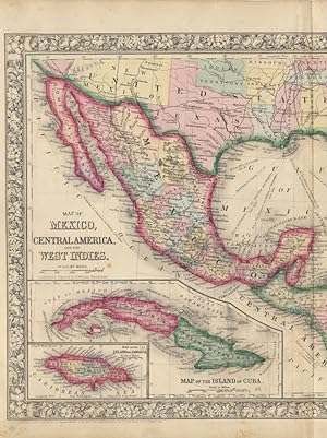
Map of Mexico, Central America, and the West Indies
Verlag: S. Augustus Mitchell, Jr., New York, 1860
Anbieter: Main Street Fine Books & Mss, ABAA, Galena, IL, USA
Verbandsmitglied: ABAA ILAB MWABA
Verkäuferbewertung 5 von 5 Sternen
Karte
Folio (23˝" X 15Ľ", image area 21Ľ" X 13Ľ"). Hand colored. Very good. Some age toning and minor soiling (mainly about edges), with single small inoffensive stain and single vertical fold (as issued). Wonderfully colored centerfold map of this large region, from the 1864 edition of "Mitchell's New General Atlas, Containing Maps of the Various Countries of the World, Plans of Cities, Etc." Two insets at upper right show "Map of the Bermuda Islands" and "Map of the Panama Railroad," while another pair at lower left show "Map of the Island of Cuba" and "Map of the Island of Jamaica." Much of the southern U.S. is visible as well: Part of California and New Mexico, all of Texas, Louisiana, Mississippi, Alabama, Georgia, Florida, Arkansas, Tennessee, both Carolinas and more partial states. Nicely colored, with sharp floral border.
-
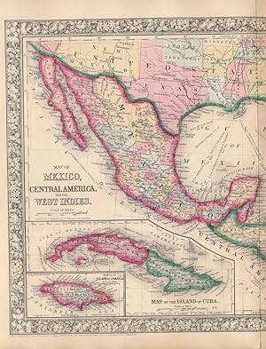
Map of Mexico, Central America, and the West Indies
Verlag: S. Augustus Mitchell, Jr., New York, 1860
Anbieter: Main Street Fine Books & Mss, ABAA, Galena, IL, USA
Verbandsmitglied: ABAA ILAB MWABA
Verkäuferbewertung 5 von 5 Sternen
Karte
Folio (23˝" X 15Ľ", image area 21Ľ" X 13Ľ"). Hand colored. Very good. Lightly age toned, with single vertical fold (as issued). Bright and fetching centerfold map of this large region, from the 1864 edition of "Mitchell's New General Atlas, Containing Maps of the Various Countries of the World, Plans of Cities, Etc." Two insets at upper right show "Map of the Bermuda Islands" and "Map of the Panama Railroad," while another pair at lower left show "Map of the Island of Cuba" and "Map of the Island of Jamaica." Much of the southern U.S. is visible as well: Part of California and New Mexico, all of Texas, Louisiana, Mississippi, Alabama, Georgia, Florida, Arkansas, Tennessee, both Carolinas and more partial states. Handsomely colored, with fine decorative border.
-

Carte Generale des Iles Antilles, des Iles et Bancs de Bahama, des Etats-Unis de l'Amerique-Centrale, de la Mer du Mexique, etc.
Erscheinungsdatum: 1845
Anbieter: Geographicus Rare Antique Maps, Brooklyn, NY, USA
Verbandsmitglied: ABAA ESA ILAB
Verkäuferbewertung 4 von 5 Sternen

Karte Erstausgabe
Hardcover. 1st Edition. Very good. Light wear along original centerfold. Even overall toning. Closed margin tears professionally repaired on verso. Size 25 x 38 Inches. This is a beautiful and wonderfully detailed Adrien-Hubert Brué and Charles Picquet 1845 map of the West Indies. Published 4 years after the Federal Republic of Central America ceased to exist, the map still illustrates that short-lived Central American republic. A Closer Look Depicting the region from the Gulf Coast of the United States south to northern South America, islands throughout the Caribbean are illustrated and labeled from Cuba south to Trinidad and Tobago. The Bahamas appear in detail, with individual islands, straits, banks, and other locations all labeled. Cuba, Haiti, and Jamaica are all illustrated with the same level of detail, with coastal locations, cities, towns, lakes, and even road networks all noted. A table below Haiti lists the six administrative divisions of the island republic. Cities, towns, and coastal features are also identified throughout the rest of the Antilles. All the islands are shaded in different colors to indicate which colonial power claimed which island. A key to the color scheme appears just below the inset maps in the upper right corner. These focus on the Virgin Islands and the two French colonies, Martinique and Guadeloupe. Central America benefits from the same attention to detail. Cities, towns, villages, rivers, mountains, and coastal locations are all labeled. Countries are identified using outline color, with the largest, the Federal Republic of Central America, outlined in pink. However, Picquet's information must have been outdated because the Federal Republic of Central America ceased to exist in 1841. The United Provinces of Central America The United Provinces of Central America (1823 - 1839/1841) was a country in Central America that also went by the name Federal Republic of Central America. In September 1821, the Captaincy General of Guatemala declared independence from Spain. In January 1822, the First Mexican Empire annexed this territory, which would not regain its independence until 1823. Five states combined to create the Federal Republic: Costa Rica, El Salvador, Guatemala, Honduras, and Nicaragua. The Federal Republic based its government on that of the United States and adopted a constitution in November 1824. The first presidential election was held in April 1825, but the elected president, Manuel José Arce, had to make compromises to get elected. This led to a civil war from 1827 until 1829. A new president was elected in 1830, but the country again descended into civil war in 1838. By 1840, the states within the Federal Republic declared their independence, and the Federal Republic ceased to exist. Publication History and Census This map was 'reviewed, corrected, and augmented' by Charles Piquet (or rather his son, Pierre-Jacques Picquet, since Charles died in 1827) and published by Piquet in 1845. The first edition appeared in 1832 and was created by Adrien-Hubert Brué. We note 4 examples of the present 1845 edition in OCLC, which are part of the collections at Florida State University, the University of Texas at Arlington, the Bibliothčque nationale de France, and the Biblioteca Nacional de Espańa. Pierre-Jacques Picquet continued publishing editions of this map through at least the late 1850s. The Picquet firm's embossed seal and stamp appear just above the title. References: OCLC 39487189, 494437544, 431784860.
-

General Chart of the West Indies from the latest Marine Journals and Surveys.
Erscheinungsdatum: 1789
Anbieter: Geographicus Rare Antique Maps, Brooklyn, NY, USA
Verbandsmitglied: ABAA ESA ILAB
Verkäuferbewertung 4 von 5 Sternen
Karte Erstausgabe
Soft cover. 1st Edition. Very good. Right and left margins extended. Minor wormhole infill in northern Florida. Laid on archival tissue to stabilize a few old edge tears and seam splits. Size 28.5 x 39.75 Inches. An important c. 1789 - 1794 nautical map of the West Indies, Florida, the Bahamas, and the Gulf of Mexico littoral by Osgood Carleton and John Norman. This is the second edition of John Norman's first published nautical chart, representing one of the first instances of post-Revolutionary American commercial chart making, predating the publication of the Clark Pilot by several months. A Closer Look Coverage extends from the Gulf of Mexico littoral to the Gulf of Panama, embracing Florida, all of the West Indies, including the Greater and Lesser Antilles, the Bahamas, the Yucatan, Central America, and the northern parts of South America. There are extensive and novel soundings north of the Yucatan and around Florida, particularly along the western coast of the peninsula. Although drawn, engraved, and sold by John and William Norman, the chart features a printed certification by Osgood Carleton, a well-known Boston-based expert on navigation. Historical Context The map is derived from a similar chart of the same name published in the 1780s in London by Sayer and Bennet. Although European sea charts were the norm throughout the Revolutionary period, the United States was rapidly emerging as an economic, industrial, and seagoing power. As more engravers, papermakers, and printers established themselves in the former British Colonies, demand rose for economical domestically produced charts of the same caliber as European charts. Although Clark has been attributed as the publisher of the first American nautical atlas, it was John Norman, and later his son William Norman, who actually produced the charts and took up the challenge of supplying the American maritime trade. Their work paved the way for other American hydrographers, including Edmund Blunt, to establish their own firms. A Complicated Publication History This map was most likely engraved in 1789 by John Norman at the request of Bartholomew Burges (c. 1740 - 1807). Burges was a maritime lecturer and mathematician who on August 3, 1789, published a subscription proposal for a set of 12 nautical charts in the Boston Gazette . That proposal suggested the set would include a map of the West Indies engraved by John Norman. In his promotion, Burges boldly claimed the charts would be approved by the Boston Marine Society. Affronted, the Marine Society interviewed Burges, but refused to lend its name to the project, determining that 'Burges has produced no recommendation of his character and scientific abilities'. In his response, Burges begged the society to examine the one chart already complete - one engraved by John Norman sometime before August 1789. It remains unclear which chart that was. Burges was again rejected by the Marine Society. Burges turned to Matthew Clark (1748 - 1798). Clark was not a publisher or hydrographer, but as an auctioneer and shipbuilder, had deep connections in the Marine Society. Where Burges's was rejected, Clark received approval. He made his first appeal to the Marine Society in October 1789 and, together with the respected local chartmaker and mathematician Osgood Carleton, presented their case in January 1790. They brought with them several charts, suggesting that Norman must have been hard at work between August, when only one chart was complete, and October, by which time 'several' were ready for presentation. Also around this time, Clark had forced Burges (and possibly Norman) from the project. Clark proceeded to publish the Pilot and separate charts in the winter of 1790. The full complement included 18 charts, offered both separately and as a bound set. Most were engraved by Norman, with added charts by Joseph Seymour. In most, but not all, Burges' name was effaced. Burges himself relocated to New York in the Spring of 1790, where he published a notice to '.
-

Cruising in the Pirates' Paradise Hamburg-American Line. / Pleasure Pirate Pilgrimages to the West Indies and the Spanish Main Cruises by the S.S. Reliance.
Erscheinungsdatum: 1927
Anbieter: Geographicus Rare Antique Maps, Brooklyn, NY, USA
Verbandsmitglied: ABAA ESA ILAB
Verkäuferbewertung 4 von 5 Sternen
Karte
Soft cover. Average. Backed on archival tissue. Some damage and infill at all corners and elsewhere on the border. Size 16.75 x 22.25 Inches. This is a c. 1927 Hamburg-America pictorial map of the West Indies promoting 'Pleasure Pirate Pilgrimage' cruises. The map evokes the romanticization of the 'pirate' and exotification of the Caribbean, as well as the decadence of the Roaring '20s. Pleasure Pirate? As described by a c. 1927 magazine advertisement, the Hamburg-America S.S. Reliance offered pirate-themed cruise adventures throughout the West Indies and Caribbean A special entertainment feature of these cruises is the activity of the renowned 'Order of Pleasure Pirates'. Headed by Kaptain Kidder and this Board of Buccaneers, the jollifications of the Order introduce, in a modern setting, the colorful atmosphere of the pirates of old and appeal to an inborn sense of romance and adventure that lurks in the heart of every traveler on pleasure bent. Members of the order enjoy themselves clad in pirate costumes, in the picturesque Pirates' Den and elsewhere on board and their program of festivities includes initiation ceremonies, pirate meetings, treasure hunts, pirate balls and other interesting 'stunts'. Pirate Pleasure Pilgrimages were introduced by Hamburg-America in 1926 and advertised until at least 1929 - likely the service lost popularity when the decadence of the Roarin' 20s was brought down by Black Thursday and the onset of the Great Depression. A Closer Look The map focuses on the West Indies, covering from southern Florida to Trinidad, thus embracing the Bahamas, the Greater and Lesser Antilles, and parts of northern South America. Stylized 'pleasure pirates' play golf, bury treasure, frolic on beaches, fly airplanes, and fish. Major ports visited by the Reliance are highlighted with signs. The overall style gives the impression of screen printing, but we cannot say with certainty. Publication History and Census This promotional map was printed in the United States. The only indication of the artist is a cryptic logo in the lower right. We have dated it based on contemporaneous advertisements for the 'Pleasure Pirate' cruises, which appear from 1926 - 1929. This is the only known example. References: 'Pirates of the Caribbean: Soft Exoticism and the Aesthetics of Diversity', in Essays: Exploring the Global Caribbean, ed. Roberson, S., (Cambridge Scholars).
-

Carte du Golfe du Mexique et des Isles Antilles.
Erscheinungsdatum: 1795
Anbieter: Geographicus Rare Antique Maps, Brooklyn, NY, USA
Verbandsmitglied: ABAA ESA ILAB
Verkäuferbewertung 4 von 5 Sternen
Karte
Hardcover. Very good. Even overall toning. Printed on French Revolution blue handkerchief paper. Blank on verso. Size 14 x 18 Inches. This is a strikingly engraved c. 1795 Edme Mentelle and Pierre-Gilles Chanlaire map of the West Indies that is notably printed on high quality light French Revolution blue handkerchief paper, which briefly appeared during the French Revolution. The map depicts the region from Central America to the Atlantic Ocean and from the Gulf Coast of the United States to northern South America. Beautifully engraved, myriad locations throughout the region are labeled, including islands, archipelagos, and points and capes along the islands' coastlines. New Orleans and St. Augustine are labeled in the southern United States, along with Charleston (Charles Town) and numerous rivers. Regions in New Spain (Nouvelle Espagne) are labeled, as are towns, lakes, and mountains. French Blue Paper The map is printed on fine laid paper with a distinctly blue tint. Blue papers appear in Europe as early as the 15th century, but rose exponentially in popularity in the second half of the 18th century. At the time, papermills collected used rags, which were the broken down into fibers and processed into paper - hence the term 'rag paper'. Blue dies were popular in the European fine-textile industry - particularly among the elite who used blue fabrics for table linens, bed linens, and clothing. Blue dies were less fugitive than other colors, and so were preserved through the papermaking pulpification process. During the French Revolution, the expansive linen closes of the nobility were raided with many of the fine textiles finding their way into papermills. This led to a surplus of blue cloth. Papermakers began experimenting with adding small amounts of blue pulp to stand bleached white pulps, to even out the color and tone - often leading to fine papers with a striking bluish cast - as here. By the end of the 18h century, the fashion for blue paper declined considerably in favor of more traditional white papers. Today maps produced from French Revolution blue paper are highly desirable. Publication History and Census This map was engraved by Pierre Francois Tardieu and P. J. Valet and published by Edme Mentelle and Pierre-Gilles Chanlaire c. 1795. References: Boston Public Library Normon B. Leventhal Map Center G4900 1797 .C37x.
-

Carte de L'Isle de la Martinique Colonie Francoise dans les Illes Antilles.
Erscheinungsdatum: 1780
Anbieter: Geographicus Rare Antique Maps, Brooklyn, NY, USA
Verbandsmitglied: ABAA ESA ILAB
Verkäuferbewertung 4 von 5 Sternen
Karte
Very good. Original centerfold. Platemark visible. Blank on verso. Size 13 x 9 Inches. A fine example of Rigobert Bonne and Guilleme Raynal's 1780 map of the Island of Martinique. Highly detailed, showing towns, rivers, some topographical features, political boundaries and important ports. Mountains shown in profile. Drawn by R. Bonne for G. Raynal's Atlas de Toutes les Parties Connues du Globe Terrestre, Dressé pour l'Histoire Philosophique et Politique des Établissemens et du Commerce des Européens dans les Deux Indes .
-

West Indies.
Erscheinungsdatum: 1835
Anbieter: Geographicus Rare Antique Maps, Brooklyn, NY, USA
Verbandsmitglied: ABAA ESA ILAB
Verkäuferbewertung 4 von 5 Sternen
Karte Erstausgabe
1st Edition. Very good. Original platemark visible. Minor spotting at places. Blank on verso. Size 8.5 x 10.5 Inches. This beautiful map of the West Indies was printed in 1835 by the important American mapmaker T. G. Bradford. Centered on the island of Hispaniola (Santo Domingo), it covers the Caribbean from southern Florida, south as far as the Gulf of Panama and the Spanish Main, and east to Barbados and the Lesser Antilles. The Bahamas (Bahama Islands), parts of Honduras, the Panama Bay, Guatemala and Nicaragua are also included. Towns, rivers, mountains and various other important topographical details are noted. Elevation throughout is rendered by hachure and political and regional territories are color coded. This map was published as plate no. 68 in Thomas G. Bradford's 1835 Comprehensive Atlas Geographical, Historical and Commercial . Bradford's atlas, published in 1835 was an important work on many levels. First, it was one of the first American atlases to follow an encyclopedic format, offering readers extensive geographical and statistical tables to supplement the maps themselves. Second, it was published in Boston and influenced the city's rise as a publishing center later in the 19th century (at the time most publishing in the United States was restricted to New York and Philadelphia). Third, this atlas was the first to contain a separate and specific map showing the Republic of Texas. Fourth and finally, Bradford's atlas in some instances broke the Euro-centric mold regarding atlas production. Among other things, Bradford focused his atlas on the Americas and abandoned the classical decoration common in European atlases in favor of a more informational and inherently American approach. Bradford published this atlas in several editions and with various partners. The first edition was published by William D. Ticktor and did not contain the iconic Republic of Texas map (although we have in fact seen Ticktor examples with a Texas map, suggesting, against conventional wisdom, that there may have been two Ticktor editions). The second official edition, published in the same year by the American Stationers Company, was the first to contain the Republic of Texas map, which is based on Austin's map, with two pages of descriptive text. A third edition was issued in 1836, also by American Stationers (though still dated 1835), and contained an unaltered Republic of Texas map with only a single page of descriptive test. A fourth edition appeared later, possibly 1837, and included an updated and revised map of Texas that replaces the old Mexican land grants with new inchoate counties. The maps from this atlas are an important addition to any collection focusing on early American cartography and Republic of Texas cartography. All maps in this atlas, though not specifically noted as such, were most likely engraved by G. W. Boynton of Boston, who also engraved most of the maps for Bradford's later publication. References: Rumsey 2643.078 (1838 edition).
-

West Indies.
Erscheinungsdatum: 1849
Anbieter: Geographicus Rare Antique Maps, Brooklyn, NY, USA
Verbandsmitglied: ABAA ESA ILAB
Verkäuferbewertung 4 von 5 Sternen
Karte
Very good. Size 11 x 14 Inches. This is Jeremiah Greenleaf's 1849 map of the West Indies and Florida. It is one of the few maps to illustrate the ephemeral settlement of Jonathan Lewis just south of the Miami River. A Closer Look The map follows 1834 David H. Burr map of the same region - and may well be the same plate, as we note few if any changes. Cape Florida Settlement (the precursor of Miami, settled around 1820 - 1825) is labeled. This is one of the few maps to identify 'Lewis', referring to the 640-acre Spanish-era grants given to Jonathan Lewis and other descendants of John Egan just south of the Miami River. The Antilles are given the greatest attention, with a focus on colonial spheres of influence - here defined with color coding. The site of Columbus' 1492 landing, Guanahani St. Salvador (Cat Island), is noted. Publication History and Census This map is the later Greenleaf issue of the David Hugh Burr map of 1834. The Burr map plates fell into the hands of Jeremiah Greenleaf, who revised them for publication in his own Universal Atlas . The present example is from the 1849 edition of the atlas, the last and final, which was extensively revised over the 1848. We note an example in the David Rumsey collection, which has been populated digitally throughout OCLC, making a comprehensive survey of existing physical examples nearly impossible. Nonetheless, the 1849 edition of the atlas is rare, which Rumsey correctly notes is not in Karpinski. We do note an example, however, in Phillips. References: Rumsey 15176.062.
-

Charte von West_Indien oder den Antillischen_Inseln.
Erscheinungsdatum: 1822
Anbieter: Geographicus Rare Antique Maps, Brooklyn, NY, USA
Verbandsmitglied: ABAA ESA ILAB
Verkäuferbewertung 4 von 5 Sternen
Karte
Very good. Light wear along original fold lines. Light transferrence. Blank on verso. Size 12.25 x 16.5 Inches. This is a rare 1822 map of the Caribbean prepared by Czech engraver Franz Pluth. The map depicts the region from the Yucatan Peninsula to the islands of Martinique, St. Lucia, and Trinidad and Tobago and from southern Florida and the Bahamas to northern South America, then referred to as 'Terra Firma'. Highly detailed and beautifully colored, nearly all of the islands in the region are identified, including numerous islands in the Bahamas, Jamaica, the Virgin Islands, Guadeloupe, Grenada, and Curaçao. The coasts of Cuba, Hispaniola, and Jamaica are illustrated in detail, with numerous locations identified on each of these islands. Cozumel is labeled off the coast of Mexico as well. The colors utilized here were not simply chosen for their aesthetic qualities; in fact, they refer to the colonial power in possession of the territory at the time. A key along the left border informs the viewer that territory bordered in green was Spanish, territory bordered in purple was English, and so on. This map was produced by Franz Pluth in 1822.
-

West Indies.
Erscheinungsdatum: 1849
Anbieter: Geographicus Rare Antique Maps, Brooklyn, NY, USA
Verbandsmitglied: ABAA ESA ILAB
Verkäuferbewertung 4 von 5 Sternen
Karte
Very good. Minor foxing and overall toning. Minor edge wear. Size 12.5 x 15.5 Inches. This is a fine example of Mitchell's 1849 map of the West Indies. It covers from Florida and the Bahamas south through the Caribbean islands of Cuba and Hispaniola (Haiti & the Dominican Republic) to the northern Part of South America and east to the Caribbee Islands or the Lesser Antilles. Includes the Bahamas (Bahama Islands). The whole is engraved and colored in Mitchell's distinctive style with green border work and vivid pastels. Political and topographical features are noted and color coded with elevation rendered by hachure. The whole is engraved and colored in Mitchell's distinctive style with green border work and vivid pastels. Mitchell published this chart in his atlas from 1846 to the late 1850s before discontinuing the series and selling his map plates to DeSilver. This map was issued in the 1849 edition of the New Universal Atlas . It was the last edition of that atlas to be published by Mitchell prior to selling the plates and rights to the atlas to Thomas Cowperthwait in 1850. References: Rumsey 0545.042.
-

Colonies Francaises Martinique. Amerique du Sud.
Erscheinungsdatum: 1852
Anbieter: Geographicus Rare Antique Maps, Brooklyn, NY, USA
Verbandsmitglied: ABAA ESA ILAB
Verkäuferbewertung 4 von 5 Sternen
Karte
Very good. Blank on verso. Wide clean margins. Size 11.5 x 17 Inches. This is a fascinating 1852 map of the Caribbean island of Martinique. Covers the island in full showing roads, cantons, the city of Port-Royal, and various anchorages. The map proper is surrounded by elaborate decorative engravings designed to illustrate both the natural beauty and trade richness of the land. There is a short textual history of the region depicted to the left of the map. Today Martinique, with its French Caribbean culture, lush rainforests, and stunning beaches is considered a jewel of the Caribbean. Published by V. Levasseur in the 1852 edition of his Atlas National de la France Illustree. References: Phillips (Atlases) 3003.
-

West India Islands. / Martinico. / Dominica. / Cul de Sac Royal.
Erscheinungsdatum: 1814
Anbieter: Geographicus Rare Antique Maps, Brooklyn, NY, USA
Verbandsmitglied: ABAA ESA ILAB
Verkäuferbewertung 4 von 5 Sternen
Karte
Very good. Some Offsetting. Size 20.75 x 24 Inches. A fine example of John Thomson's stunning c. 1814 hand-colored map of the West India islands of Dominica and Martinique, engraved by Kirkwood and Son for the 1817 edition of Thomson's General Atlas . A Closer Look Divided into two sections, this map offers spectacular detail of these two picturesque islands. Both sections offer detail to the level of individual buildings noting churches, convents, villages, hospitals, and forts. Some sailing hazards and portages are also noted, along with mountains, rivers, caves, forests, and river systems. In the lower-left hand quadrant, there is an inset of the Cul-de-Sac Royal (modern day Fort-de-France). Publication History and Census This map was prepared by John Thomson and engraved by (Robert) Kirkwood and Son in Edinburgh for inclusion in Thomson's New General Atlas , which went through multiple printings in Edinburgh, London, and Dublin between 1815 and 1817. Examples of the map display different pagination (or none at all) and other minor details depending on the printing, with the plate number here (No. 66) seemingly added separately from the main plate. References: Rumsey 1007.072. Phillips (Atlases) 731. Newberry Library: Ayer +135 T4 1817.
-

West Indies. Guadaloupe. Antigua. MarieGalante etc.
Erscheinungsdatum: 1814
Anbieter: Geographicus Rare Antique Maps, Brooklyn, NY, USA
Verbandsmitglied: ABAA ESA ILAB
Verkäuferbewertung 4 von 5 Sternen
Karte
Good. Light offsetting. Trimmed unevenly at left edge. Size 20.5 x 24 Inches. An example of John Thomson's hand-colored 1814 map of the West India islands of Antigua, Guadeloupe, and Marie-Galante. A Closer Look The West Indian islands of Antigua, Guadeloupe, and Marie-Galante are depicted in detail with attention to rivers, topography, towns and villages, and major port cities. Even individual buildings, including churches and windmills, are illustrated. Saint John (Saint John's) on Antigua stands out for its size and geometric plan. The modern history of these islands was defined by the slave trade and plantation economies, but the years immediately preceding this map's publication were highly tumultuous, especially for Guadeloupe, which saw foreign invasion (it changed hands between Britain, France, and, briefly, Sweden, during the French Revolutionary and Napoleonic Wars (1803 - 1815)), the abolition and reimposition of slavery, and consequent slave uprisings. Publication History and Census This map was prepared by John Thomson and engraved by (Robert) Kirkwood and Son in Edinburgh for inclusion in Thomson's New General Atlas , which went through multiple printings in Edinburgh, London, and Dublin between 1815 and 1817. Examples of the map display different pagination (or none at all) and other minor details depending on the printing. References: Catalogue of maps of Hispanic America, v. 1, p. 245. Rumsey 1007.071 (alternate printing).
-

A Chart of the West Indies From the Latest Marine Charts and Surveys.
Erscheinungsdatum: 1796
Anbieter: Geographicus Rare Antique Maps, Brooklyn, NY, USA
Verbandsmitglied: ABAA ESA ILAB
Verkäuferbewertung 4 von 5 Sternen
Karte
Average. Centerfold split repaired on verso. Size 11.5 x 15.75 Inches. This is a c. 1796 map of the West Indies from Carey's General Atlas , the first atlas published in the new American Republic. A Closer Look at the Map The map stretches from the Spanish and French colonies of West Florida and Louisiana at north to the modern states of Columbia, Venezuela, and Guyana in the south. A small key at bottom-left lists the abbreviations used to distinguish the ownership for various islands and territories between competing empires. One interesting feature of this map is the use of Philadelphia, where it was engraved and published, as the prime meridian. It also includes a scale of nautical leagues along the right side of the map. Publication History and Census This map is likely from an early edition of Carey's General Atlas (sometimes subtitled American Edition of Guthrie's Geography improved ), multiple editions of which were printed between 1795 and 1818. This is likely an early edition as later editions included colored ink to show borders between countries or to shade entire countries to more easily distinguish them. The map itself provides some clues as to its date, as it appears to predate the dispute over West Florida between Spain and the United States (later editions of the map remove West Florida). The western half of Hispaniola is referred to as belonging to France, so the map must predate 1804, when Haiti became independent. The prevalence of the map is difficult to determine since it is not always cataloged with the year recorded and there is a proliferation of catalog listings for the Carey atlas maps, but it appears to be held by a handful of universities and research institutions in the United States while being scarce to the market. References: Rumsey 2862.043. OCLC 70802719, 53079559.
-

West India Islands. / St. Christoperhs. / St. Lucia. / Nevis.
Erscheinungsdatum: 1814
Anbieter: Geographicus Rare Antique Maps, Brooklyn, NY, USA
Verbandsmitglied: ABAA ESA ILAB
Verkäuferbewertung 4 von 5 Sternen
Karte Erstausgabe
1st Edition. Very good. Original centerfold exhibits some light toning. Transference. Original platemark visible. Size 20.5 x 24 Inches. This is John Thomson's 1814 map of the Caribbean Islands of St. Kitts, St. Lucia, and Nevis. This map was issued in the year St. Lucia was ceded to the British Empire. A Closer Look The sheet presents three separate maps: The main map focuses on St. Kitts (St. Christophers). A smaller inset appears at bottom center, expanding coverage of southeast of St. Kitts to include nearby Nevis. A third inset, in the lower right, details St. Lucia. All three focus on costal features, with very little inland detail, likely betraying Thomson's sources as nautical charts. Nonetheless, important churches and topographical elements are noted. St. Kitts and Nevis - Historical Context In 1814, St. Kitts, also known as Saint Christopher, and nearby Nevis, were key jewels in the British colonial Caribbean crown. Having been contested over by both the British and French across previous centuries, it solidified as a British possession in the 1713 Treaty of Utrecht. The island's economy was anchored in the plantation system, primarily centered around sugar production, which relied heavily on the labor of enslaved Africans. Today, St. Kitts, as part of the federation of St. Kitts and Nevis, is a vibrant Caribbean nation known for its rich history, stunning natural beauty, and diverse cultural heritage. Moving beyond its colonial and sugar-centric past, the island has successfully pivoted towards tourism as a primary economic driver. St. Lucia - Historical Context In the year this map was issued 1814, St. Lucia was formally and permanently ceded to Great Britain after over a century of changing hands. The island nonetheless bore cultural imprints from both empires. Sugar cane plantations sprawled across its landscapes, underpinned by the labor of enslaved Africans, making it a vital cog in the lucrative West India sugar economy. Publication History and Census This map was prepared and engraved in 1814 in Edinburgh for inclusion in the 1817 first edition of John Thomson's New General Atlas . It was engraved by Robert Kirkwood and his son, also Robert. The map is well represented in institutions and appears on the market from time to time. References: Rumsey 1007.070. Phillips (Atlases) 731.
-

Carte de l'Isle de Sainte Lucie. Pour servir a l'Histoire Generale des Voyages.
Erscheinungsdatum: 1758
Anbieter: Geographicus Rare Antique Maps, Brooklyn, NY, USA
Verbandsmitglied: ABAA ESA ILAB
Verkäuferbewertung 4 von 5 Sternen
Karte
Very good. Platemark visible. Blank on verso. Size 9 x 13 Inches. An extremely attractive example of Jacques-Nicolas Bellin's 1758 map of Saint Lucia (St. Lucia) or Sainte Lucie in the West Indies. St. Lucia is considered among the most beautiful of the Windward Isles. This map covers this spectacular Caribbean island in considerable detail showing mountains, cities, and forests in Bellin's distinctive profile style. Good harbors are marked with miniature anchors. A decorative rococo style title cartouche appears in the upper left quadrant. Drafted in 1758 by Jacques-Nicolas Bellin for publication in Provost's c. 1760 edition of L`Histoire Générale des Voyages . References: OCLC 956309372.
-

St. Vincent. / Barbadoes. / West India Islands.
Erscheinungsdatum: 1814
Anbieter: Geographicus Rare Antique Maps, Brooklyn, NY, USA
Verbandsmitglied: ABAA ESA ILAB
Verkäuferbewertung 4 von 5 Sternen
Karte Erstausgabe
1st Edition. Very good. Original centerfold. Some offsetting. Size 21 x 25 Inches. This is John Thomson's 1814 map of Barbados and St. Vincent, both part of the Lesser Antilles volcanic arc, West Indies. It illustrates the final days of slavery on both islands, and coincides with a period marked by internal strife, social upheaval, economic decline, and rebellion. Barbados From the 17th century, Barbados was one of the most prosperous British West Indian colonies with a large slave-driven sugar-growing economy. As evident on this map, there are hundreds of plantations and sugar mills - represented tiny windmills - scattered throughout, with landowners named. Nonetheless, when this map was issued, slavery was in decline in British colonies and with it, the plantation economy. In 1816, when this map was being printed, Barbados' enslaved rose up in the first of three rebellions in the British West Indies, and the largest slave uprising in the island's history. The rebellion largely surprised planters, who felt their slaves were content because they were allowed weekly dances, participated in social and economic activity, and were generally fed and looked after - notwithstanding the Barbados Slave Code, which denied slaves human rights and prescribed inhumane torture, mutilation, or death as a means of control. Unlike, neighboring St. Vincent, which is mountainous and densely jungled, Barbados offered wide flat terrain, which strongly favored British rather than guerilla tactics. The rebellion failed militarily, and most combatants were deported. It did, however, set the stage for progressive legislative reform culminating in the abolition of slavery on Barbados by 1834. St. Vincent The map reveals St. Vincent during a period of economic decline. St. Vincent was first occupied by the French but was ceded to England after the Seven Years' War (1756 - 1763). Like the French before them, the British maintained only a tenuous control over the island, with powerful Carib tribes dominating the mountainous north and western slopes - as shown here. The First Carib War (1769 - 1773) ended in a stalemate. The Second Carib War began in 1795. With the support of French Revolutionary advisors and troops from Martinique, the Caribs pushed towards the British stronghold of Kingstown. They were ultimately repulsed when British reinforcements, led by General Ralph Abercromby, led a major expedition into Carib-held territory. More than 5,000 black Caribs were deported from Saint Vincent first to the island of Baliceaux, off Bequia, where half of them died in concentration camps, and then to the island of Roatán off the coast of present-day Honduras, where they later became known as the Garifuna people. In the following decades, the British attempted to establish a plantation economy, but the abolition of slavery in 1838 left most plantations abandoned and the economy in a long decline. Publication History and Census This map was prepared and engraved in 1814 in Edinburgh by Kirkwood and Sons for inclusion in the 1817 first edition of John Thomson's New General Atlas . References: Rumsey, 1007.073. Catalogue of maps of Hispanic America, v. 1, p. 245.
-

West Indies.
Erscheinungsdatum: 1846
Anbieter: Geographicus Rare Antique Maps, Brooklyn, NY, USA
Verbandsmitglied: ABAA ESA ILAB
Verkäuferbewertung 4 von 5 Sternen
Karte Erstausgabe
1st Edition. Very good. Minor foxing and toning. Light soiling. Blank on verso. Size 12.5 x 15.5 Inches. This is a first edition 1846 Samuel Augustus Mitchell map of the West Indies. The map depicts the region from Florida and the Bahamas to northern part of South America and from Guatemala and western Cuba to the 'Caribee Islands,' the Winward and Leeward Islands. Each individual island is identified, and cities and towns are labeled throughout. Points, bays, and other coastal features are also labeled. A list just below the scale entitled 'possessions of the European Powers' groups the islands together by whichever colonial power 'possessed' them at the time. It does note, however, the Haiti was an independent republic. The whole is engraved and colored in Mitchell's distinctive style with green border work and vivid pastels. Publication History This map was published by Mitchell in the 1846 edition of his New Universal Atlas . This is the only edition to bear the Tanner copyright imprint in the lower left corner. It would be removed for the second edition of Mitchell's atlas which was published later in 1846.
-

Mexico and the West Indies.
Erscheinungsdatum: 1826
Anbieter: Geographicus Rare Antique Maps, Brooklyn, NY, USA
Verbandsmitglied: ABAA ESA ILAB
Verkäuferbewertung 4 von 5 Sternen
Karte
Good. Original outline and wash color. Closed margin tears professionally repaired on verso. Verso repair to centerfold separation. Light wear along original centerfold. Light soiling. Upper margin trimmed to page numbers. Size 15.25 x 23.25 Inches. This is a striking old color example of Charles Smith rare 1826 map of Mexico, the West Indies, and Central America. A Closer Look Coverage embraces from North Carolina south to northern South America, embracing the entirety of the Gulf of Mexico, Florida, and the West Indies. Islands throughout the West Indies are labeled, including individual islands within the Bahamas and the Virgin Islands. Cities, towns, and villages, along with coastal capes and bays, are labeled in Cuba, Santo Domingo, Puerto Rico (Porto Rico), and many of the Lesser Antilles. In Mexico, cities, towns, and villages appear, and black dots mark significant mines. In Central America, inland detail includes a few cities and towns. Rivers are illustrated throughout, including the Rio Grande del Norte (Rio Grande) in modern-day Texas and the Mississippi. Only rivers and state names (without borders) appear within the U.S. Text below the title and scale notes which islands were the colonial possessions of which European power. Publication History and Census This map was drawn by J. Smith, engraved by J. Pickett, and published by Charles Smith in 1826. We note four examples cataloged in OCLC: Southern Methodist University, the University of North Texas, the University of Texas at Arlington, and the Daughters of the Republic of Texas Library in San Antonio, Texas. References: OCLC 55496470.
-

Arcipelago delle Antille ossia Indie Occidentali. (America.)
Erscheinungsdatum: 1850
Anbieter: Geographicus Rare Antique Maps, Brooklyn, NY, USA
Verbandsmitglied: ABAA ESA ILAB
Verkäuferbewertung 4 von 5 Sternen
Karte
Very good. Closed margin tears professionally repaired on verso. Size 18 x 24.5 Inches. This is an 1850 Benedetto Marzolla Italian map of the Caribbean Sea, or West Indies. Coverage extends from the U.S. Gulf Coast to northern South America. Color coding associates European colonial influence with individual islands. A statistical table, situated in the upper right, provides population and area of each island. Also, it acts as the color key: British colonies (red), Spanish colonies (yellow), and Dutch colonies (green). French and Danish colonies are also marked with shades of red, making differentiation between British, French, and Danish colonies slightly difficult. Italian text appears along the right side and bottom of the map and provides a 'general description' of the region along with more detailed descriptions of Cuba, Haiti, Jamaica, and Puerto Rico. Publication History and Census This map was created and published by Benedetto Marzolla in 1850 for publication in his 1856 Atlante Geografico . We note an example of the complete atlas in the David Rumsey Map Collection. The separate map is not cataloged in OCLC. References: Rumsey 4714.042.
-

West Indies.
Erscheinungsdatum: 1814
Anbieter: Geographicus Rare Antique Maps, Brooklyn, NY, USA
Verbandsmitglied: ABAA ESA ILAB
Verkäuferbewertung 4 von 5 Sternen
Karte
Very good. Minor toning and verso repair along original centerfold. Size 20.5 x 24.5 Inches. This is a fascinating 1814 map of the West Indies and Central America by the Edinburgh cartographer John Thomson. It covers from the Carolinas south through Texas, Mexico and Central America to the northern part of South America as well as Venezuela and the Orinoco Delta. It includes all of the West Indies including the Caribbean and the Greater and Lesser Antilles. Wonderful details with notations on both physical and political features, as well as undersea elements, banks, and shoals. Several American Indian tribes in both North and South America are noted. This map is magnificent in size, beautiful in color, and high in detail. References: Rumsey 1007.066.
-

A New and Accurate Map of Mexico or New Spain together with California, New Mexico etc. Drawn from the best Modern Maps and Charts and Regulated by Astronl. Obsrvrn. By Eman: Bowen.
Erscheinungsdatum: 1747
Anbieter: Geographicus Rare Antique Maps, Brooklyn, NY, USA
Verbandsmitglied: ABAA ESA ILAB
Verkäuferbewertung 4 von 5 Sternen
Karte
Very good. Few small wormholes. Else excellent. Old color, possibly original. Size 14 x 16.75 Inches. This is Emmanuel Bowen's c. 1747 map of Mexico and the southern part of what would become the United States, an area at this time contested between Spain and England. The whole is rife with interesting anti-Spanish propaganda. A Closer Look The map's scope reaches from Santa Fe south to the Isthmus of Panama and the Varagua region in Central America, embracing from southern California in the west to Florida in the east. The colonies of Georgia and Carolina are named. New Orleans appears at the mouth of the Mississippi. The names of Indigenous nations, dioceses, and royal jurisdictions are noted throughout Mexico. An inset in the lower left presents a detailed map of the Galapagos Islands, including notes derived from Captain Cowley's 1684 description of the islands. The map's cartouche depicts two natives brutally subjugated, chained, and held at swordpoint by a Spaniard. (One could tell by the hat, and besides, English anti-Spanish and anti-Catholic propaganda would have been immediately recognizable in the context of this map.) California Not An Island The map presents Baja California as a peninsula, and the Sea of California as a bay. Even as late as 1747, though, the notion of an insular California was still so prevalent that Bowen was required to include a gloss text disabusing readers of that notion: California, which has been Described and Represented as an Island even by very modern Geographers, was discovered by Father Eusebius Francis Kino, a Jesuit, to be a Peninsula between the years 1698 and 1701. Publication History and Census This map was created and published by Emanuel Bowen for inclusion as plate no. 58 in the 1747 edition of A Complete System of Geography . While not dated, the present example is plate number 110 and thus must hail from a later edition. The census of state changes for this map is incomplete, and the dating of these maps in institutional collections is inconsistent. References: OCLC 39717976. Rumsey 3733.057. Wheat, C.I. Mapping the Transmississippi West, #126.
-

Mexique, Antilles, Etats-Unis.
Erscheinungsdatum: 1864
Anbieter: Geographicus Rare Antique Maps, Brooklyn, NY, USA
Verbandsmitglied: ABAA ESA ILAB
Verkäuferbewertung 4 von 5 Sternen
Karte
Excellent. Light wear along original centerfold. Size 22.25 x 29.75 Inches. This is an 1864 Adolphe Hippolyte Dufour Civil War Era map of the United States - one of the few maps to name Colona, the ephemeral proto-state predating Colorado, Shoshone (pre-Idaho), the unincorporated territory of Dacotah, and the secessionist Confederate Arizona. A Closer Look The map depicts the continental United States, Mexico, Central America, the West Indies, and northern South America. Countries are outlined in broad hand color, while thinner borders illustrate states within the United States and Mexico. Colored borders in the West Indies indicate the colonial possessions of Denmark (gray), Spain (yellow), France (blue), Great Britain (red), the Netherlands (brown), and Sweden (green). Within the United States, Native American tribes are identified near their traditional ranges. Railroads are highlighted by thin black lines. Colona and Shoshone: Proposed Territories Two early regional names appear: Colona, roughly corresponding to Colorado, and Shoshone, which would soon become Idaho Territory. Colona was a proposed territory roughly corresponding to modern-day Colorado. A proposal for 'Colona,' occupying the mountainous western parts of what was then Nebraska and Kansas, was put forth in 1859. The hope was for territorial status to enable self-governance, regulation, and administration of what was quickly becoming one of America's greatest gold and silver mining centers. Congress, focused on the struggle between slave and free states in the fractious lead-up to the American Civil War (1861 - 1865), found it easier to ignore the petition. Nonetheless, Colorado was recognized as a territory two years later in 1861. The Colona petition was largely forgotten. Shoshone was a proposed new territory roughly corresponding to modern-day Idaho. The Shoshone are a group of Native American tribes that live in the northwest United States. 'Shoshone' was used generically to refer to their ranging lands and was proposed as an official territory name. Modern-day Dakota and Idaho are believed to be derived from Shoshone words. Idaho Territory was incorporated in 1863, Shoshone Territory was forgotten. Dacotah and Minnesota During the nearly 3-year period between Minnesota's statehood on May 11, 1858, and the creation of the Dakota Territory on March 2, 1861, the Pembina Region between the Missouri River and Red River (Minnesota's newly-created western border) was unattached to any territory. Following Minnesota's statehood, a provisional government was established in the Pembina to lobby for territorial self-governance. The Federal government ignored the proposal until the Dakota Territory was formed in 1861, which, upon its creation, included most of present-day Montana, Wyoming, and both North and South Dakota. Confederate Arizona Although the Confederate States of America are not illustrated here, Confederate Arizona occupies the lower third of the New Mexico Territory. Confederate Arizona was a territory claimed by the Confederate States of America from 1861 until 1865. The idea for an Arizona Territory appeared as early as 1856 when the government of the Territory of New Mexico began to express concerns about being able to effectively govern the southern part of the territory, as it was separated from Santa Fe by the Jornada del Muerto, a particularly unforgiving stretch of desert. The New Mexico territorial legislature acted on these concerns in February 1858, approving a resolution to create an Arizona Territory, with a north-south border to be defined along the 32nd parallel. Impatiently waiting for Congress to approve the creation of the new territory, 31 delegates met at a convention in Tucson in April 1860 and drafted a constitution for the 'Territory of Arizona,' which was to be organized out of the New Mexico Territory below 34th parallel. The convention even elected a territorial governor and a delegate to Congress. Congress, however, was relu.
-

Insulae Americanae, Nempe: Cuba, Hispaniola, Jamaica, Pto Rico, Lucania, Antillae vulgo Caribae, Barlo -Et Sotto - Vento. Etc.
Erscheinungsdatum: 1696
Anbieter: Geographicus Rare Antique Maps, Brooklyn, NY, USA
Verbandsmitglied: ABAA ESA ILAB
Verkäuferbewertung 4 von 5 Sternen
Karte Erstausgabe
1st Edition. Very good. Marginal mend at bottom centerfold not affecting image. Else excellent with a bold strike and fine original color. Size 19.5 x 22.75 Inches. This is Cornelius Danckerts' rare 1696 map of Florida, the West Indies, Central America, the Caribbean, and the Spanish Main. This map covers from Mexico to the Antilles and from Florida to the Spanish Main, inclusive of Cuba, the Bahamas, Hispaniola, Jamaica, Porto (Puerto) Rico, and the Lesser Antilles. It extends as far north as Georgia and South Carolina, here referred to as 'Florida Gallica'. Unique in a Long Lineage Danckerts' map shares a similar title, and broad geographical features, with a number of maps produced in the 17th century. All, including Blaeu's 1635 Insulae Americanae , can be traced to Hessel Gerritsz' unobtainable 1631 chart De Eylanden Ende Vastelanden van Westindien op de Noordzee for their coastal detail. The interior detail is drawn from the 1680 Visscher Insulae Americanae in Oceano Septentrionali . The map is not a rote copy of the Visscher: although it employs a large copperplate similar to other late-seventeenth-century Dutch maps, Danckerts' map presents a narrower area as shown on the earlier Blaeu and Gerritsz maps, thus focusing more sharply on the Caribbean and the Gulf Coast than the Visscher, while sharing that map's inland cities, topographical details and place names. Florida Florida is labeled as the province of 'Tegesta,' following the convention established by Dutch cartographers Johannes de Laet and Hessel Gerritz in 1630. The Tegesta were an indigenous tribe in southeastern Florida, around what is today Miami-Dade. They were encountered in the 16th century by Ponce de Leon and by one of the ships commanded by Pedro Menéndez de Avilés. Though largely subject to the more powerful tribes of western Florida, the Tegesta were among the first of Florida's indigenous groups to encounter Europeans and subsequently influenced the naming of Florida for some 200 years. Curiously, despite several expeditions and interesting earlier maps of Florida, Danckerts has chosen to leave the interior blank, noting neither the Everglades nor any of Florida's great lakes. This interesting cartographic decision to discard all previous mappings of the Florida region contrasts strikingly with the remainder of the map, which is lavishly and often speculatively detailed. The Gulf Coast Following the western coast of Florida north along the Gulf and then west towards Texas and Mexico, we can begin to see just how little was known of the Gulf Coast despite nearly 200 years of European activity. The Mississippi River is entirely absent, though a great fan-shaped river system does radiate northward from the Bay of Spiritu Santo (likely Galveston Bay). Looking northward and inland from the Gulf Coast, a number of communities appear in reference to various indigenous groups encountered by the De Soto and Coronado expeditions - these include the Chicasa, the Talacasa (whose warriors nearly overwhelmed and slaughtered De Soto's army), and the Achusi. The Caribbean and Bahamas The West India Islands, centered on Cuba, are mapped with considerable accuracy although universally distorted on the north-south axis. The Bahamas are vaguely and inaccurately mapped throughout, although some attempt has been made to depict the undersea Bahama Bank. San Salvador or Guanahani, the supposed island where Columbus is said to have first landed, is noted. Central America The southwestern quarter of the map is dominated by a strikingly accurate Central America, despite the exception of a distorted Yucatan - which here appears almost like an inversion of a similarly distorted Florida just to the northeast. Both Lake Nicaragua and the adjacent Lake Managua are noted, but are situated on an east-west rather than the correct north-south axis. Key Strategic Cities Along the Spanish Main the great trading cities of Cartagena, Venezuela, and Valencia are noted, as are a number of missions an.