Map ireland (41 Ergebnisse)

Sprache: Englisch
Verlag: CASSELL, PETTER & GALPIN, London 1865
- Erstausgabe
Anbieter: K Books Ltd ABA ILAB, York, YORKS, Vereinigtes KönigreichK Books Ltd ABA ILAB
Verkäufer/-in kontaktierenVerkäufer/-in mit 5 SternenZustand: Gebraucht - Gut
EUR 23,75
EUR 22,59 VersandVersand von Vereinigtes Königreich nach USAAnzahl: 1 verfügbar
Single Sheet. Zustand: Very Good. No Jacket. First Edition. NORTHER IRELAND, AN ANTIQUE MAP, CIRCA 1865 MEASURES 25 X 16 INCHES, 63 X 43 CMS, GOOD CONDITION, WE PACK VERY WELL, TOO LARGE TO SEND MOUNTED SO DISPATCHED ROLLED IN A STRONG TUBE.SPLENDID VALUE --. Edward WELLER (illustrator).
Sprache: Englisch
Verlag: CASSELL. PETTER & GALPIN, London 1865
Anbieter: K Books Ltd ABA ILAB, York, YORKS, Vereinigtes KönigreichK Books Ltd ABA ILAB
Verkäufer/-in kontaktierenVerkäufer/-in mit 5 SternenZustand: Gebraucht - Gut
EUR 23,86
EUR 22,59 VersandVersand von Vereinigtes Königreich nach USAAnzahl: 1 verfügbar
No Binding. Zustand: Very Good. A very detailed original antique map, showing roads, railways, rivers, hills etc. no date of publication but c1865, counties coloured in outline, central fold - impressive and reasonably priced.
Ireland - An Original Antique Map.
IRELAND. . An Original Antique Contemporary 19th C. Hand-Coloured map.
Sprache: Englisch
Verlag: Chapman & Hall 1870
Anbieter: K Books Ltd ABA ILAB, York, YORKS, Vereinigtes KönigreichK Books Ltd ABA ILAB
Verkäufer/-in kontaktierenVerkäufer/-in mit 5 SternenZustand: Gebraucht - Gut
EUR 23,86
EUR 22,59 VersandVersand von Vereinigtes Königreich nach USAAnzahl: 1 verfügbar
No Binding. Zustand: Very Good. A splendid original antique contemporary 19th C. hand-coloured map. Mounted (matted) and ready to fame. Mount size approx. 12.5 x 9.5 inches, 32 x 25 cms. Excellent condition.
Sprache: Englisch
Anbieter: K Books Ltd ABA ILAB, York, YORKS, Vereinigtes KönigreichK Books Ltd ABA ILAB
Verkäufer/-in kontaktierenVerkäufer/-in mit 5 SternenZustand: Gebraucht - Gut
EUR 17,90
EUR 22,59 VersandVersand von Vereinigtes Königreich nach USAAnzahl: 1 verfügbar
No Binding. Zustand: Very Good. An antique map, very good condition. Mounted - matted - and ready to frame. Mount size approx 12 x 10 inches, 36 x 30 cms. Original contemporary colouring. Circa 1880. Very detailed - Shows Ireland and all the counties coloured in outline - attractive and reasonably priced.
Sprache: Englisch
Verlag: BRIGHTLY & KENNEDY, Bungay, Suffolk 1807
Anbieter: K Books Ltd ABA ILAB, York, YORKS, Vereinigtes KönigreichK Books Ltd ABA ILAB
Verkäufer/-in kontaktierenVerkäufer/-in mit 5 SternenZustand: Gebraucht - Gut
EUR 35,79
EUR 22,59 VersandVersand von Vereinigtes Königreich nach USAAnzahl: 1 verfügbar
No Binding. Zustand: Very Good. An original, hand-coloured engraved map; colouring not contemporary, but delicately and expertly done. Will come mounted (matted) and ready to frame - mount size 13 x 11 inches. An opportunity to buy a decorative and attractive antique map of Ireland. Barlow (illustrator).
Sprache: Englisch
Anbieter: K Books Ltd ABA ILAB, York, YORKS, Vereinigtes KönigreichK Books Ltd ABA ILAB
Verkäufer/-in kontaktierenVerkäufer/-in mit 5 SternenZustand: Gebraucht - Befriedigend
EUR 23,86
EUR 22,59 VersandVersand von Vereinigtes Königreich nach USAAnzahl: 1 verfügbar
No Binding. Zustand: Good. An original antique map, mounted and ready to frame. Decorative and with considerable detail, scarce - detailed map. Very Attractive. c 1850. Shows the whole of Ireland, with the counties outlined in colour. Hughes, W (illustrator).
Sprache: Englisch
Anbieter: K Books Ltd ABA ILAB, York, YORKS, Vereinigtes KönigreichK Books Ltd ABA ILAB
Verkäufer/-in kontaktierenVerkäufer/-in mit 5 SternenZustand: Gebraucht - Gut
EUR 29,83
EUR 22,59 VersandVersand von Vereinigtes Königreich nach USAAnzahl: 1 verfügbar
No Binding. Zustand: Very Good. A splendid original antique coloured map . Colouring contemporary but delicately and expertly executed . Mounted - matted - and ready to frame . Very good . A fine map showing Tipprtary and Waterford.
Ireland - Fine Detailed Map - an Original Engraving
MAP OF IRELAND - an Antique Original Hand Coloured Engraving
Sprache: Englisch
Anbieter: K Books Ltd ABA ILAB, York, YORKS, Vereinigtes KönigreichK Books Ltd ABA ILAB
Verkäufer/-in kontaktierenVerkäufer/-in mit 5 SternenZustand: Gebraucht - Gut
EUR 29,83
EUR 22,59 VersandVersand von Vereinigtes Königreich nach USAAnzahl: 1 verfügbar
No Binding. Zustand: Very Good. A fine engraving - printed circa 1860. Mounted and ready to frame. Hand colouring not contemporary, but delicately and expertly executed. A fine opportunity to purchase an attractive and decorative engraving - Ireland - Fine Detailed Map.
Sprache: Englisch
Anbieter: K Books Ltd ABA ILAB, York, YORKS, Vereinigtes KönigreichK Books Ltd ABA ILAB
Verkäufer/-in kontaktierenVerkäufer/-in mit 5 SternenZustand: Gebraucht - Gut
EUR 35,79
EUR 22,59 VersandVersand von Vereinigtes Königreich nach USAAnzahl: 1 verfügbar
No Binding. Zustand: Very Good. An original hand-coloured antique engraved map. Hand-colouring not contemporary but delicately and expertly executed. Mounted and ready to frame. A fine opportunity to purchase an attractive and decorative engraving - Ireland - Fine Map Showing Names of Places, Roads Etc.
Sprache: Englisch
Anbieter: K Books Ltd ABA ILAB, York, YORKS, Vereinigtes KönigreichK Books Ltd ABA ILAB
Verkäufer/-in kontaktierenVerkäufer/-in mit 5 SternenZustand: Gebraucht - Gut
EUR 35,79
EUR 22,59 VersandVersand von Vereinigtes Königreich nach USAAnzahl: 1 verfügbar
No Binding. Zustand: Very Good. A splendid original antique hand coloured map. Mounted (matted) and ready to frame . A wonderful opportunity to acquire a vintage map, ca. 1830.
Sprache: Englisch
Anbieter: K Books Ltd ABA ILAB, York, YORKS, Vereinigtes KönigreichK Books Ltd ABA ILAB
Verkäufer/-in kontaktierenVerkäufer/-in mit 5 SternenZustand: Gebraucht - Gut
EUR 41,76
EUR 22,59 VersandVersand von Vereinigtes Königreich nach USAAnzahl: 1 verfügbar
No Binding. Zustand: Very Good. An original hand-coloured antique map. Hand-colouring not contemporary but delicately and expertly executed. Mounted (matted) and ready to frame. Map of the whole of the island of Ireland showing the counties, rivers and 'railways already opened' and 'railways in progress'. The map is undated, but… must be before 1864. W HUGHES (illustrator).
Sprache: Englisch
Anbieter: K Books Ltd ABA ILAB, York, YORKS, Vereinigtes KönigreichK Books Ltd ABA ILAB
Verkäufer/-in kontaktierenVerkäufer/-in mit 5 SternenZustand: Gebraucht - Gut
EUR 47,73
EUR 22,59 VersandVersand von Vereinigtes Königreich nach USAAnzahl: 1 verfügbar
No Binding. Zustand: Very Good. A fine antique map in very good condition - printed in circa 1844. Mounted (matted) and ready to frame. Coloured in outline, hand colouring contemporary. Engraved Size 19 x 15 Ins, 48 x 38 Cms. Mounted size approx 22 x 18 in, 56 X 46 cms. A fine opportunity to purchase an attractive and decorative… engraved antique map of South Ireland. Engraved By Walker (illustrator).
Sprache: Englisch
Anbieter: K Books Ltd ABA ILAB, York, YORKS, Vereinigtes KönigreichK Books Ltd ABA ILAB
Verkäufer/-in kontaktierenVerkäufer/-in mit 5 SternenZustand: Gebraucht - Gut
EUR 47,73
EUR 22,59 VersandVersand von Vereinigtes Königreich nach USAAnzahl: 1 verfügbar
No Binding. Zustand: Very Good. A fine antique map in very good condition - printed in circa 1844. Mounted (matted) and ready to frame. Coloured in outline, hand colouring contemporary. Engraved Size 19 x 15 Ins, 48 x 38 Cms. Mounted size approx 22 x 18 in, 56 X 46 cms. A fine opportunity to purchase an attractive and decorative… engraved antique map of North Ireland. Engraved By Walker (illustrator).
Verlag: London. Published for the Proprietors Mr. Bull, Holles St., 1830 1830
Anbieter: J. Patrick McGahern Books Inc. (ABAC), Ottawa, ON, KanadaJ. Patrick McGahern Books Inc. (ABAC)
Verkäufer/-in kontaktierenVerkäufer/-in mit 4 SternenZustand: Gebraucht - Sehr gut
EUR 63,63
EUR 8,64 VersandVersand von Kanada nach USAAnzahl: 1 verfügbar
No Binding. Zustand: Fine. 16x 10cm (6.25"x 4"), (image, 9x 14cm), attractively hand coloured, fine - Bonar Law #311. p224. - One of 40 maps from the "Geographical Annual" designed and engraved by London engraver, Thomas Starling. A nice example of miniature cartography.
Verlag: S. Augustus Mitchell, Jr., New York 1860
- Karte
Anbieter: Main Street Fine Books & Mss, ABAA, Galena, IL, USAMain Street Fine Books & Mss, ABAA
Verkäufer/-in kontaktierenVerkäufer/-in mit 5 SternenZustand: Gebraucht
EUR 71,20
EUR 5,18 VersandVersand innerhalb von USAAnzahl: 1 verfügbar
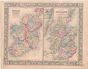
Folio (15¼" X 12¼", image area 13½" X 10½"). Hand colored. Very good. Light age toning and faint soiling. Nicelyicely-colored side-by-side map of these United Kingdom countries, from the 1864 edition of "Mitchell's New General Atlas, Containing Maps of the Various Countries of the World, Plans of Cities, Etc." Sharp floral borde…r.

Verlag: S. Augustus Mitchell, Jr., New York 1860
- Karte
Anbieter: Main Street Fine Books & Mss, ABAA, Galena, IL, USAMain Street Fine Books & Mss, ABAA
Verkäufer/-in kontaktierenVerkäufer/-in mit 5 SternenZustand: Gebraucht
EUR 89,00
EUR 5,18 VersandVersand innerhalb von USAAnzahl: 1 verfügbar
Folio (15¼" X 12¼", image area 13½" X 10½"). Hand colored. Very good. Mild age toning. Attractive, nicely-colored side-by-side map of these United Kingdom countries, from the 1864 edition of "Mitchell's New General Atlas, Containing Maps of the Various Countries of the World, Plans of Cities, Etc." Handsomely colored and with fi…ne decorative border.
Verlag: Universal Magazine, J. Hinton, Newgate Street, London 1770
Anbieter: The Old Mill Bookshop, HACKETTSTOWN, NJ, USAThe Old Mill Bookshop
Verkäufer/-in kontaktierenVerkäufer/-in mit 3 SternenZustand: Gebraucht
EUR 111,25
EUR 10,37 VersandVersand innerhalb von USAAnzahl: 1 verfügbar
Handcolored. Engraved by R. W. Seale. 1 vols. 11 3/4 x 15 1/2 inches. Folded, creases, tears in lower margin affecting latitudinal markings and blank area, short tear into image without loss, light offsetting, else in very good condition Handcolored. Engraved by R. W. Seale. 1 vols. 11 3/4 x 15 1/2 inches.

Kupferstich-Landkarte von Houdan. Carte reduite de l'entree de la mer d'Irlande et du Canal de Bristol.
Irland, Ireland, Seekarte, Sea map, Cornwall, Wales, England, Bristol -:
Verlag: Ohne Ort, , um 1805. 1805
Anbieter: Antiquariat Thomas Rezek, München, , DeutschlandAntiquariat Thomas Rezek
Verkäufer/-in kontaktierenVerkäufer/-in mit 5 SternenZustand: Gebraucht
EUR 78,00
EUR 44,00 VersandVersand von Deutschland nach USAAnzahl: 1 verfügbar
circa 92,5 x 63,5 cm. 1 gefaltetes Doppelblatt verso weiß Große Land- bzw. Seekarte des Kanals von Bristol, im Nordwesten Irland, im Südosten Cornwall. - Leicht randrissig auserhalb der Darstellung, kaum fleckig. Gut erhalten.
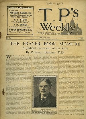
T. P.'s Weekly | Volume X Issue Number 239. | May 26, 1928 | H. E. Bates 'The Parrot'; John Masefield [Drawn by Joseph Simpson].
Thomas Power O'Connor (5 October 1848 - 18 November 1929), known as T. P. O'Connor and occasionally as Tay Pay (mimicking his own pronunciation of the initials T. P.), was a journalist, an Irish nationalist political figure, and a member of parliament (MP) in the House of Commons of the United Kingdom of Great Britain and Ireland for nearly fifty years. O'Connor founded and was the first editor of several newspapers and journals: The Star (1887), the Weekly Sun (1891), The Sun (1893), M.A.P. and T.P.'s Weekly (1902). Includes Articles and Stories by: H. E. Bates; John Masefield [Drawn by Joseph Simpson];
Verlag: Published by The Amalgamated Press Ltd., The Fleetway House, Farringdon Street, London First Edition May 26 1928. 1928
- Erstausgabe
Anbieter: Little Stour Books PBFA Member, Canterbury, Vereinigtes KönigreichLittle Stour Books PBFA Member
Verkäufer/-in kontaktierenVerkäufer/-in mit 5 SternenZustand: Gebraucht - Befriedigend
EUR 113,35
EUR 34,75 VersandVersand von Vereinigtes Königreich nach USAAnzahl: 1 verfügbar
Zustand: Good. First edition in publisher's white paper printed stapled tabloid 12" x 9½". New short stories and articles by: H. E. Bates 'The Parrot' A Complete Story; John Masefield [Drawn by Joseph Simpson]. Photographs and illustrated advertisements. Extremely rare. Staples weeping and in Good condition. Member of the P.B.F.…A. BATES, H. E. (1906-1974).
Verlag: London. 1780 1780
Anbieter: J. Patrick McGahern Books Inc. (ABAC), Ottawa, ON, KanadaJ. Patrick McGahern Books Inc. (ABAC)
Verkäufer/-in kontaktierenVerkäufer/-in mit 4 SternenZustand: Gebraucht - Sehr gut
EUR 159,08
EUR 8,64 VersandVersand von Kanada nach USAAnzahl: 1 verfügbar
No Binding. Zustand: Fine. 33.4x 24cm, (14.25"x 9.5"), image 31x21cm, hand-coloured, topographical, decorated cartouche, coloured engraved illustrations outside the borders, a fine copy. - Bonar Law 123(i) . Cartouche "Appears in the bottom right in a crumbling stone block to the right of which are a pair of barrels and a fishin…g smack. There is a single scale line towards the top left. Outside the border across the top is the imprint "Engrav'd for Moore's News. at the top on both sides is a small decorative motif the central part of which is a mermaid blowing a horn. Across the bottom is a cannon at the left joined by a chain to a helmet in the centre joined by another chain to a vignette of cannon balls and ramming tools, etc. at the right.
Anbieter: Hermann L. Strack, Loguivy Plougras, , FrankreichHermann L. Strack
Verkäufer/-in kontaktierenVerkäufer/-in mit 5 SternenZustand: Gebraucht
EUR 35,20
EUR 48,00 VersandVersand von Frankreich nach USAAnzahl: 1 verfügbar
1 folded (37.5 x 44 cm) engraved map (??l?Irlande par J.D. Barbié du Bocage??). A beautiful map of Ireland, with in the left upper corner ??Plan des Lacs de Killarney?? and in the lower right corner ??Tour danoise?? with some ruins.

Verlag: Amsterdam. W. & J. Blaeu.1654-62 1654
Anbieter: J. Patrick McGahern Books Inc. (ABAC), Ottawa, ON, KanadaJ. Patrick McGahern Books Inc. (ABAC)
Verkäufer/-in kontaktierenVerkäufer/-in mit 4 SternenZustand: Gebraucht - Gut
EUR 318,16
EUR 8,64 VersandVersand von Kanada nach USAAnzahl: 1 verfügbar
No Binding. Zustand: Very Good. 47x 58.5cm, (image 38x 44cm; 15"x 17.5"), decorated cartouche, outline hand-coloured, Latin text on verso related to another map (Greenland), toning stripe along center fold, decorative watermark, cleaned with some fading to colour, some short tears on the margins, very good A very attractive map…from Blaeus' "Atlas of Scotland" ( Volume V) first published in 1654.
Verlag: Amsterdam. Chez les Freres Chatelain. 1709 1709
Anbieter: J. Patrick McGahern Books Inc. (ABAC), Ottawa, ON, KanadaJ. Patrick McGahern Books Inc. (ABAC)
Verkäufer/-in kontaktierenVerkäufer/-in mit 4 SternenZustand: Gebraucht - Sehr gut
EUR 509,06
EUR 8,64 VersandVersand von Kanada nach USAAnzahl: 1 verfügbar
No Binding. Zustand: Fine. 45x 53cm, 17.75"x 20.75", (image 35.5x 6). on plate 35.5cm x 46cm(13in x 18in), a fine bright copy, rare Bonar Law. #46. p90. The copper-plate maps from Chatelain's "Atlas Historique" (1705-1720) are based on the work of French cartographer, Guillaume De L'Isle. Tables include ancient peoples, places,…etc. The maps shows the ancient names.
 Weitere Bilder
- Hardcover
- Erstausgabe
- Karte
Anbieter: Geographicus Rare Antique Maps, Brooklyn, NY, USAGeographicus Rare Antique Maps
Verkäufer/-in kontaktierenVerkäufer/-in mit 4 SternenZustand: Gebraucht
EUR 2.491,94
EUR 14,69 VersandVersand innerhalb von USAAnzahl: 1 verfügbar
Hardcover. 1st Edition. Excellent. Light marginal soiling; marginal mend to bottom of top sheet not impacting printed image. Each separate image approximately 13.5 x 18.5 inches respectively; measurement above given for printed image if joined. Size 26.75 x 18.5 Inches. This is a superb, 1595 first atlas edition of Gerard Mercat…or's two-sheet map of Ireland. It is the most detailed of the early atlas maps of Ireland, and one of the earliest printed maps to be substantially based on actual surveys - to wit, the surveys of Robert Leith. A Closer Look The map is on two sheets included consecutively in Mercator's atlas. Both maps are oriented to the north and overlap slightly in coverage. The untitled first sheet extends from Galway in the south to embrace points north, including part of Scotland and the Isle of Islay. The second sheet spans from the southern point of Dublin Harbor to the southern part of Ireland. Both sheets exhibit Mercator's superb engraving - the elegantly hachured waves of the north sheet are patrolled by two ships and prowled by a sea monster, while the bottom corners of the south sheet are embellished with a superb strapwork cartouche. Mountains and forests on both sheets are indicated pictorially. As ever, Mercator's meticulous Italic lettering affords the legible inclusion of a host of placenames - crucial with this map, as it is the earliest acquirable, detailed map of Ireland derived from Leith's surveys, which contributed over three thousand Irish placenames to the geographical lexicon. A Revolution in Irish Mapmaking Mercator had addressed the geography of Ireland previously, in his 1564 wall map of the British Isles, probably derived from the maps of Laurence Nowell. Mercator's delineation of Ireland in that map was influential as Ortelius reproduced it faithfully in his 1573 map of Ireland. Nonetheless, by the time Mercator produced the present map, he had moved beyond his earlier work. A cursory comparison of the hist 1564 Ireland and this map reveals drastic differences. The level of detail, along with the ubiquity of Irish place names, suggests access to detailed surveys, executed in Ireland, by an Irish or English mapmaker. A convincing candidate is Robert Lythe, whose 1567-1571 tenure as military engineer under Sir Henry Sidney, the Queen's deputy added over three thousand Irish place names to the historical record. During this period, Lythe surveyed the east and south coasts from Carrickfergus to Sheep's Head, followed by surveys of the interior and west coast as far as the southern Connaught. The regions of Ulster and north Connaught proved too dangerous for Leith. Consequently, these areas are much distorted on the present map and show scant place names. This part of the map relies heavily on Mercator's 1564 work. J. H. Andrews, in his 1992 address to the 24th Annual Name Study Conference in Belfast, identifies Mercator's maps among those 'based wholly or largely' on Lythe's surveys. Over 90% of Lythe's place names were at least attempts at the original Irish names, rather than English replacements; thus the present work represents a remarkable glimpse of Irish toponymy of the 16th century. The resultant geography remained state of the art well into the 17th century. Publication History and Census Mercator himself engraved these plates for inclusion in his Atlas , although he would not live to see them published as this first edition appeared a year after his death. The plates were later purchased by Jodocus Hondius, who continued to use them as the basis for his own atlases, gradually adding additional plates. They remained in the Hondius / Jansson atlases unchanged until 1636, at which point Mercator's imprint was removed. Shortly thereafter, Jansson replaced these maps with entirely new work. The present sheets are examples of the first state, conforming typographically with examples of the 1595 first Latin edition of Mercator's Atlas . In various editions, examples appear on the market from time to time and the.
Verlag: Amsterdam. Chez les Freres Chatelain. 1708 1708
Anbieter: J. Patrick McGahern Books Inc. (ABAC), Ottawa, ON, KanadaJ. Patrick McGahern Books Inc. (ABAC)
Verkäufer/-in kontaktierenVerkäufer/-in mit 4 SternenZustand: Gebraucht - Sehr gut
EUR 636,32
EUR 8,64 VersandVersand von Kanada nach USAAnzahl: 1 verfügbar
No Binding. Zustand: Fine. 45x 52.5cm, (17.5"x 20.5"), (image 34.5x 46cm), with 2 small inset maps: 11cm x 8cm (4.5cm x 3cm), uncoloured, indexes, in fine condition The copper-plate maps from Chatelain's "Atlas Historique", published 1705-1720, in 7 vols. are based on the work of French cartographer, Guillaume De L'Isle. There w…ere four issues/editions of this seven volume atlas; 1705-1720, 1712-20, 1718-120 & 1732-1739. In these subsequent edition the present map appears in Vol. 3. The inset maps are of ancient Ireland and contemporary ecclesiastical Ireland with descriptions, in French, on both. Tables include political, ecclesiastical and geographical information. - "Title appears outside the neat line across the top. The main map is again flanked by columns of engraved text. In this instance each column is headed by a small map of the country, that on the left shows the ancient religious divisions, that on the right the present day (1708) divisions. There is a single scale line towards the border of the main map. The box at the title now has 'Tome 2 / Nop 58' and the imprint Avec Privilege de Nosseigneurs les Etats'd'Hollande et de Westfri; appear at the bottom of the left column". Bonar Law #47.

- Erstausgabe
- Karte
Anbieter: Geographicus Rare Antique Maps, Brooklyn, NY, USAGeographicus Rare Antique Maps
Verkäufer/-in kontaktierenVerkäufer/-in mit 4 SternenZustand: Gebraucht
EUR 99,68
EUR 14,69 VersandVersand innerhalb von USAAnzahl: 1 verfügbar
1st Edition. Very good. Original platemark visible. Minor spotting at places. Blank on verso. Size 10.5 x 8.5 Inches. This is a beautiful 1835 map of the British Islands by the important American mapmaker T. G. Bradford. It includes England, Scotland, Wales and Ireland and covers from the southern tip of the Shetland Islands to…the Scilly Isles in the south. This map notes towns, rivers, mountains, canals, and various other important topographical details. Elevation throughout is rendered by hachure and political and regional territories are color coded. As this map was being printed, the Kingdom of Great Britain and the Kingdom of Ireland had already amalgamated into a single political entity. England and Scotland were in the midst of the Industrial Revolution. Though England and Scotland flourished throughout the 19th century, Ireland suffered a series of famines, the worst being the Great Irish Famine, which lasted from 1845 1849 and killed about a million people. This map was published as plate no. 81 in Thomas G. Bradford's 1835 Comprehensive Atlas Geographical, Historical and Commercial . Bradford's atlas, published in 1835 was an important work on many levels. First, it was one of the first American atlases to follow an encyclopedic format, offering readers extensive geographical and statistical tables to supplement the maps themselves. Second, it was published in Boston and influenced the city's rise as a publishing center later in the 19th century (at the time most publishing in the United States was restricted to New York and Philadelphia). Third, this atlas was the first to contain a separate and specific map showing the Republic of Texas. Fourth and finally, Bradford's atlas in some instances broke the Euro-centric mold regarding atlas production. Among other things, Bradford focused his atlas on the Americas and abandoned the classical decoration common in European atlases in favor of a more informational and inherently American approach. Bradford published this atlas in several editions and with various partners. The first edition was published by William D. Ticktor and did not contain the iconic Republic of Texas map (although we have in fact seen Ticktor examples with a Texas map, suggesting, against conventional wisdom, that there may have been two Ticktor editions). The second official edition, published in the same year by the American Stationers Company, was the first to contain the Republic of Texas map, which is based on Austin's map, with two pages of descriptive text. A third edition was issued in 1836, also by American Stationers (though still dated 1835), and contained an unaltered Republic of Texas map with only a single page of descriptive test. A fourth edition appeared later, possibly 1837, and included an updated and revised map of Texas that replaces the old Mexican land grants with new inchoate counties. The maps from this atlas are an important addition to any collection focusing on early American cartography and Republic of Texas cartography. All maps in this atlas, though not specifically noted as such, were most likely engraved by G. W. Boynton of Boston, who also engraved most of the maps for Bradford's later publication. References: Rumsey 2643.091 (1838 edition).

- Kunstdruck
Anbieter: Antiquariat Martin Barbian & Grund GbR, Saarbruecken, , DeutschlandAntiquariat Martin Barbian & Grund GbR
Verkäufer/-in kontaktierenVerkäufer/-in mit 5 SternenZustand: Gebraucht
EUR 75,00
EUR 45,00 VersandVersand von Deutschland nach USAAnzahl: 1 verfügbar
Anonymer Kupferstich, London bei Alex Hogg, 1782, 28,5x19,5 cm (etwas schief auf das Blatt gedruckt, daher rechts unten etwas knapprandig).

- Karte
Anbieter: Geographicus Rare Antique Maps, Brooklyn, NY, USAGeographicus Rare Antique Maps
Verkäufer/-in kontaktierenVerkäufer/-in mit 4 SternenZustand: Gebraucht
EUR 124,60
EUR 14,69 VersandVersand innerhalb von USAAnzahl: 1 verfügbar
Very good. Minor wear along original centerfold. Original platemark visible. Minor spotting. Size 18 x 14.5 Inches. This is a beautiful 1874 map of the British Isles or Great Britain and Ireland by Ambroise Tardieu. It includes England, Wales, Scotland and Ireland and covers from the Shetland Islands to the English Channel. Thro…ughout, the map identifies various cities, towns, rivers and an assortment of additional topographical details. During this time in history, Scotland was in the midst of the Industrial Revolution and emerging as the center of engineering and shipbuilding in the British Isles. Britain at the time was experiencing a rapid expansion of its empire to include India and parts of Africa. This map was prepared by Ambroise Tardieu and issued as plate 13 in his 1874 edition of Atlas Universel de Geographie Ancienne et Moderne . References: Rumsey 4697.017 (1863 edition).

- Karte
Anbieter: Geographicus Rare Antique Maps, Brooklyn, NY, USAGeographicus Rare Antique Maps
Verkäufer/-in kontaktierenVerkäufer/-in mit 4 SternenZustand: Gebraucht
EUR 249,19
EUR 14,69 VersandVersand innerhalb von USAAnzahl: 1 verfügbar
Very good. Size 16.75 x 21.75 Inches. Published immediately after World War II, this is a 1947 Ernest Clegg pictorial map of Northern Ireland. The map celebrates Northern Ireland's role in securing an Allied victory in Europe during World War II. A Detailed Look at the Map Northern Ireland's six counties are identified by block…lettering and shaded different colors to allow for easy differentiation. Lough Neagh, Lough Foyle, and Lough Erne are present as well. Banners bearing red block lettering proclaims each region's agricultural products (and, by extension, their agricultural contribution to the war effort), including oats, potatoes, flax, orchards, cattle, and poultry. Cities and towns throughout Northern Ireland are labeled, including Belfast, Bangor, Londonderry, and Omagh, and Enniskillen, which are all highlighted by pictorial icons. The Map, Northern Ireland, and World War II Pictorial vignettes illustrate warships and merchant ships in the seas off the Northern Irish coast, including part of the armada participating in the D-Day invasion of Normandy. Blocks of text situated along the border promote Northern Ireland's war-time contributions, including the importance of the Londonderry Naval Base, Belfast's harbor and shipyards, and of Royal Air Force (R.A.F.) bases. A quote from Sir Winston Churchill, dated May 6, 1943, credits Northern Ireland with being critical to the perseverance of the British people and their ultimate victory. A view situated in the upper right corner illustrates the Parliament Buildings, which housed R.A.F. Headquarters in Northern Ireland from October 1942 until February 1945. The other view, which adorns the lower left corner, depicts Caledon House, the ancestral home of Field Marshal Viscount Alexander. The insignia of five important Northern Irish units adorn the upper left corner as part of the decorative title cartouche. Publication History and Census This map was designed and drawn by Ernest Clegg, devised by Donald McCullogh, and reproduced and printed by John Waddington, Limited, in 1947. Five examples are cataloged in OCLC and are part of the institutional examples at the Library of Congress, the National Library of Scotland, the University of Cambridge, Stanford University, and the Biblioteca Comunale di Trento in Trento, Italy. An example is part of the David Rumsey Map Collection. References: David Rumsey Map Collection, 8090.000. OCLC 707400394.

Les Isles Britanniques Comprenant les Royaumes D'Angleterre, D'Ecosse et D'Irlande divises en Grandes Provinces.
1771 Janvier Map of the British Isles ( England, Wales, Scotland, Ireland )
- Karte
Anbieter: Geographicus Rare Antique Maps, Brooklyn, NY, USAGeographicus Rare Antique Maps
Verkäufer/-in kontaktierenVerkäufer/-in mit 4 SternenZustand: Gebraucht
EUR 249,19
EUR 14,69 VersandVersand innerhalb von USAAnzahl: 1 verfügbar
Very good. Original platemark visible. Blank on verso. Size 12 x 17.75 Inches. This is a 1771 Jean Janvier map of the British Isles. The map depicts England, Wales, Scotland, and Ireland, along with parts of France, Holland, and Belgium. The British Isles are divided according to province. An inset map on the upper right details… the Shetland and Orkney Islands. A decorative mile scale cartouche appears in the lower left corner. A decorative title cartouche depicting the British royal armorial crest is situated in the upper left corner. Drawn by Jean Janvier c. 1771 for issue in Jean Lattre's 1776 issue of the Atlas Moderne . References: Rumsey 2612.039. Malinowski, H., The Malinowski collection of maps of Poland, 506-507, 687 (1762, 1782 eds.). Phillips (Atlases) 664. National Maritime Museum, 215. British Libarary (World), col. 384-385 (1762-1785 eds.). OCLC 50278852.


