Map eastern hemisphere (12 Ergebnisse)

Sprache: Englisch
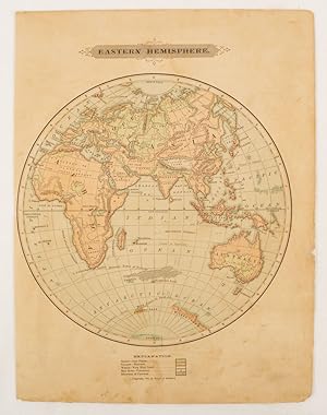
Verlag: H.G. COLLINS, London, 1840
- Erstausgabe
Anbieter: K Books Ltd ABA ILAB, York, YORKS, Vereinigtes KönigreichK Books Ltd ABA ILAB
Verkäufer/-in kontaktierenVerkäufer/-in mit 5 SternenZustand: Gebraucht - Gut
EUR 48,33
EUR 22,93 VersandVersand von Vereinigtes Königreich nach USAAnzahl: 1 verfügbar
Single Sheet. Zustand: Very Good. No Jacket. First Edition. HEMISPHERE MAP, DOUBLE HEMISPHERE MAP OF THE WORLD SHOWING THE WESTERN AND EASTERN HEMISPHERES, CIRCA 1840 MEASURES 23 X 11 INCHES, DISPATCHED IN A STRONG TUBE, WELL PACKED, REASONABLY PRICED .
Map Of the Eastern Hemisphere - Spherical Map - Fine Detailed Map - an Original Engraving
MAP OF THE EASTERN HEMISPHERE - an Antique Original Hand Coloured Engraving
Sprache: Englisch
Anbieter: K Books Ltd ABA ILAB, York, YORKS, Vereinigtes KönigreichK Books Ltd ABA ILAB
Verkäufer/-in kontaktierenVerkäufer/-in mit 5 SternenZustand: Gebraucht - Gut
EUR 54,50
EUR 22,93 VersandVersand von Vereinigtes Königreich nach USAAnzahl: 1 verfügbar
No Binding. Zustand: Very Good. A fine engraving - printed circa 1860. Mounted and ready to frame. Hand colouring not contemporary, but delicately and expertly executed. A fine opportunity to purchase an attractive and decorative engraving - Map Of the Eastern Hemisphere - Spherical Map.
Verlag: Harper & Brothers., 1875
Anbieter: Asia Bookroom ANZAAB/ILAB, Canberra, ACT, AustralienAsia Bookroom ANZAAB/ILAB
Verkäufer/-in kontaktierenVerkäufer/-in mit 5 SternenZustand: Gebraucht
EUR 47,15
EUR 18,58 VersandVersand von Australien nach USAAnzahl: 1 verfügbar
Spherical map printed in colour, 21.3 x 21.2 cm with shaded key to elevation and ocean currents, unrelated text on the verso, paper toned and margins soiled, bottom edge ragged, small sealed to to the inner margin, but in sound condition. Map showing the five continents of Asia, Africa, Antarctica, Europe, and Australia. Publish…ed by Harper & Brothers for inclusion in their "School Geography". Plateau of Tibet very prominently marked. Gobi Desert and Plateau of Mongolia also marked, India described as Hindostan, Indo-China includes Thailand.
Sprache: Englisch
Anbieter: K Books Ltd ABA ILAB, York, YORKS, Vereinigtes KönigreichK Books Ltd ABA ILAB
Verkäufer/-in kontaktierenVerkäufer/-in mit 5 SternenZustand: Gebraucht - Gut
EUR 60,56
EUR 22,93 VersandVersand von Vereinigtes Königreich nach USAAnzahl: 1 verfügbar
No Binding. Zustand: Very Good. A fine antique map - printed in 1844. Mounted (matted) and ready to frame. Engraved size approx 16 x 13 Ins, 41 x 33 Cms. Mounted size approx 19 x 16 in, 49 x 41cm. Coloured in outline, hand colouring contemporary. A fine opportunity to purchase an attractive and decorative engraved antique map of… the Eastern Hemisphere. Engraved By Walker (illustrator).
Verlag: Mitchell
- Karte
Anbieter: Main Street Fine Books & Mss, ABAA, Galena, IL, USAMain Street Fine Books & Mss, ABAA
Verkäufer/-in kontaktierenVerkäufer/-in mit 5 SternenZustand: Gebraucht
EUR 112,56
EUR 5,25 VersandVersand innerhalb von USAAnzahl: 1 verfügbar
Two maps published by Mitchell, 1880. Both measuring 12" X 15" (images 10" X 14"). Hand colored. Decorative borders. Near fine.

- Softcover
- Karte
Anbieter: Geographicus Rare Antique Maps, Brooklyn, NY, USAGeographicus Rare Antique Maps
Verkäufer/-in kontaktierenVerkäufer/-in mit 4 SternenZustand: Gebraucht
EUR 252,13
EUR 14,86 VersandVersand innerhalb von USAAnzahl: 1 verfügbar
Soft cover. Very good. Exhibits light wear along original fold lines. Size 31.25 x 31.5 Inches. This is a 1945 LIFE Magazine map of the Eastern Hemisphere highlighting Russian naval history and Soviet naval capability. This map was published only months after the end of World War II (1939 - 1945) as relations between the Western… Allies and the Soviet Union were rapidly deteriorating. Red stars with anchors mark Soviet naval bases, each of which is labeled. Two potential Soviet naval bases in Libya and Eritrea, are labeled as well. A dashed line along the coast of Siberia traces the Northeast Passage, a key transportation route during World War II. Russian Naval History Text boxes reference four historic naval battles: The Battle of Hango in 1714, the Battle of Chesme in 1770, the Battle of Sinope in 1853, and the Battle of Tsushima Strait in 1905. The Battle of Hango was the first major naval victory in the history of the Russian navy. The Battle of Chesme was a major Russian victory during the Russo-Tukish War (1768 - 1774) and was the greatest naval defeat of the Ottomans since the 1571 Battle of Lepanto. The Battle of Sinope was a precursor to the Crimean War (1854 - 1856) and was another major naval victory for the Russians over the Ottomans. The last of these four battles, the 1905 Battle of Tsushima Strait, has been deemed one of the most important naval engagements in world history, where a major power, the Imperial Russian Navy, was defeated by the 'upstart' Japanese. Publication History and Census This map is an enlargement of a map that was created for LIFE Magazine. A smaller version of the map was published in the December 17, 1945 issue of LIFE Magazine .

- Karte
Anbieter: Geographicus Rare Antique Maps, Brooklyn, NY, USAGeographicus Rare Antique Maps
Verkäufer/-in kontaktierenVerkäufer/-in mit 4 SternenZustand: Gebraucht
EUR 151,28
EUR 14,86 VersandVersand innerhalb von USAAnzahl: 1 verfügbar
Very good. Blank on verso. Minor stains. Size 12 x 10 Inches. A rare example of Colton's 1858 map of the eastern Hemisphere. Depicts Asia, europe, Africa and Australia. Although major cities are labeled, political distinctions are not. Shows major cities, rivers, mountains, capes, oceans and ocean currents. Offers a fascinating…snapshot of the world during a period of rapid globalization and discovery. This beautiful hand colored map is a copper plate engraving, featuring a delicate floral style border only used by Colton in this particular atlas. Dated and copyrighted to J. H. Colton, 1859, this map is by G. Woolworth Colton and the text is by Richard Swainson Fisher. Published from Colton's 172 William Street Office in New York City an issued as part of the1859 edition of Colton's Illustrated Cabinet Atlas and Descriptive Geography . References: Rumsey 1690.010.

- Karte
Anbieter: Geographicus Rare Antique Maps, Brooklyn, NY, USAGeographicus Rare Antique Maps
Verkäufer/-in kontaktierenVerkäufer/-in mit 4 SternenZustand: Gebraucht
EUR 151,28
EUR 14,86 VersandVersand innerhalb von USAAnzahl: 1 verfügbar
Very good condition. Size 11 x 11 Inches. This attractive hand colored map depicts the Eastern Hemisphere including Africa, Europe, Asia and Australia. Printed in 1844 by well known map publisher C. Flemming.

- Erstausgabe
- Karte
Anbieter: Geographicus Rare Antique Maps, Brooklyn, NY, USAGeographicus Rare Antique Maps
Verkäufer/-in kontaktierenVerkäufer/-in mit 4 SternenZustand: Gebraucht
EUR 403,41
EUR 14,86 VersandVersand innerhalb von USAAnzahl: 1 verfügbar
1st Edition. Very good. Minor foxing. Original platemark visible. Size 13 x 12 Inches. This is a beautiful first edition 1834 David Burr map of the Eastern Hemisphere. It covers the entirety of Asia, Africa and Europe as well as Australia and the East Indies and much of the Pacific. Important cities, rivers, islands and mountain…s, along with other topographical features are noted. Although 'New Holland' officially changed its name to Australia in 1824, it is here referred to by its older Dutch name, a term that would fall out of favor shortly after this map was printed. The interior however, is entirely unexplored. In Africa, the source of the White Nile is set in the speculative Mountains of the Moon. The interiors of Africa and Asia here follow archaic geographical conventions - giving evidence to the general lack of knowledge about these regions in the early 19th century. The Great Wall of China is noted, but not identified. According to Ristow, although Burr is credited on the title page, he left this atlas incomplete. He was appointed as topographer to the U.S. Post Office, and of the sixty-three maps finally included in this atlas, only completed eight. The rest of the maps were then completed by Illman and Pilbrow in Burr's style. The map was 'Entered according to act of Congress in the year 1834 by Illman & Pilbrow in the Clerk's office of the District Court for the Southern District of New York', but not published until the atlas was released in 1835. Engraved and Printed by Illman & Pilbrow and published by D. S. Stone in Burr's New Universal Atlas . References: Rumsey 4628.001. Philips (Atlases) 771.

- Karte
Anbieter: Geographicus Rare Antique Maps, Brooklyn, NY, USAGeographicus Rare Antique Maps
Verkäufer/-in kontaktierenVerkäufer/-in mit 4 SternenZustand: Gebraucht
EUR 504,27
EUR 14,86 VersandVersand innerhalb von USAAnzahl: 1 verfügbar
Very good condition. Minor discoloration along original centerfold. Minor dampstaining in lower margins. Blank on verso. Size 22 x 20 Inches. A rare and important 1818 map of the Eastern Hemisphere by John Pinkerton. Depicts Asia, Europe, Africa and Australia. This map offers fairly accurate shorelines throughout. In Africa, the… interior remains unexplored except for the Congo, the Cape Colony, the gold mining regions of Monomotapa, and Abyssinia. The speculative Mountains of Kong, supposed source of the Niger, cross the western part of the continent. The apocryphal Mountains of the Moon, just south of Abyssinia, are mapped but not labeled. The coasts of Australia are accurate but the interior is vague and unknown. In Asia there are several notations regarding unexplored territories in southwestern China and Central Asia. Far to the north, in the high Arctic, there is a partial land mass with the note 'Coast discovered by the Hunters employed by m. Liakhov.' This land refers to the Lyakhov Islands, discovered in the 1770s by Russian Fur trader Ivan Lyakhov. These islands, part of New Siberia, were said to have such an abundance of fossilized mammoth ivory that many of the smaller islands were formed from it in their entirety. Lyakhov himself brought back 10,000 tons of Ivory on his first trip and subsequent traders are said to have brought back as much as 100,000 tons in the following 20 years. Drawn by L. Herbert and engraved by Samuel Neele under the direction of John Pinkerton. The map comes from the scarce American edition of Pinkerton's Modern Atlas, published by Thomas Dobson & Co. of Philadelphia in 1818. References: Rumsey 0732.002. Phillips (Atlases) 724. National Maritime Museum, 409.

- Karte
Anbieter: Geographicus Rare Antique Maps, Brooklyn, NY, USAGeographicus Rare Antique Maps
Verkäufer/-in kontaktierenVerkäufer/-in mit 4 SternenZustand: Gebraucht
EUR 605,12
EUR 14,86 VersandVersand innerhalb von USAAnzahl: 1 verfügbar
Very good. Minor toning along original centerfold. Minor spotting at places. Original platemark visible. Water stains on top margin, not affecting printed area. Size 15 x 21 Inches. This is an impressive map of the Eastern Hemisphere by Desnos and Brion de la Tour dating to 1786. Depicts the Eastern Hemisphere in beautiful detai…l covering Asia, Europe, Africa and Australia. Though rife with speculation, the map attempts to present a grand overview of the known world based upon the best reconnaissance available at the time. The routes of many explorers and important recent discoveries are noted. The northeast parts of Asia, which had recently been explored by Vitus Bering and Tschirikow, are depicted with a fair approximation of accuracy. Terre de Gama and Terre de la Company, speculative mis-mappings of the Japanese Kuril Islands by the 17th century Dutch explorers Maerten de Vries and Cornelis Jansz Coen, appear just northeast of Yedso (Hokkaido). Gama or Compagnie remained on maps for about 50 years following Bering's voyages until the explorations of Cook confirmed the Bering findings. South of the equator the shores of Australia or New Holland are speculatively mapped with a dotted line defining the southern and eastern portions continent. Van Diemen's Land or Tasmania is attached to the mainland, which itself includes New Guinea and parts of the New Hebrides, identified here as Terre de S. Espirit. Terre du St. Espirit, in fact the New Hebrides was mis-mapped by the near insane 17th century Portuguese navigator Pedro Fernandes de Queiros who proclaimed that he had discovered the Great Southern Continent, or Terre Australis. Not to be confused with modern day Australia, Terre Australis was a vast speculative continent that supposedly covered much of the southern hemisphere in Aristotelian symmetry with the bulk of Asia in the Northern Hemisphere. Although by this time most cartographers had stopped mapping Terre Australis, some, perhaps with the great myth in mind, wishfully increased Australia's dimensions. To the left and right of the map are paste downs of French text with remarks and description of the map. Surrounding the whole is an elaborate decorative border featuring floral arrangements, surveying tools, elaborate baroque scalloping, and a winged globe. This map was issued as plate no. 9 in the most deluxe edition of Desnos' 1786 Atlas General Methodique et Elementaire, Pour l'Etude de la Geographie et de l'Histoire Moderne .

- Karte
Anbieter: Geographicus Rare Antique Maps, Brooklyn, NY, USAGeographicus Rare Antique Maps
Verkäufer/-in kontaktierenVerkäufer/-in mit 4 SternenZustand: Gebraucht
EUR 1.210,24
EUR 14,86 VersandVersand innerhalb von USAAnzahl: 1 verfügbar
Very good. Some wear on old fold lines. Size 42.25 x 38.94 Inches. A rare 1873 or Meiji 6 wall map of the Eastern Hemisphere by the Japanese geographer Gaiko Oya (?? ??). The map follows the early Meiji Restoration convention of copying cartography from western sources. The practice was intended to modernize Japanese geographica…l conceptions and place Japan into a geographically accurate global reference. A Closer Look Coverage here extends pole to pole and from West Africa to the Solomon Islands. Countries are defined by color coding in a finely executed 4-color system. The map is also quite large, underscoring that it was produced for classroom use at the Ishikawa Prefecture School. The map would have hung on the wall or, more likely, laid on the floor, where school children could walk around the map, studying it from different angles. Japan Finds a Place on the Global Stage This map illustrates Japan's emergence from an insular feudal nation to a rising power on the world's social, military, and economic stage. The arrival of Commodore Perry and the forced opening of Japan in 1853 transformed Japan's vision of itself, breaking the illusion that it was the sole repository of civilization and underscoring the truth that it was indeed well behind Western powers. The Meiji Restoration followed and was characterized by a major reorganization of government, a reassertion of imperial power, and a drive towards aggressive industrial and social modernization. Japan's victory over Imperial Russia in the Russo-Japanese War (1904 - 1905) marked the first major victory in war by an Asian power over a European Power, an achievement that established Japan as a global power. Publication History and Census This map was drawn by Gaiko Oya (?? ??) based on unnamed Western sources and published for the Ishikawa Prefecture School Collection. (?? ???????????). The map is rare. We note only one other known example, which is part of the collection at the National Diet Library in Japan.


