Maire jacob (20 Ergebnisse)
Relaci on Diaria del Viaje de Jacobo Le Maire y Guillermo Cornelio Schouten ... Reimpresa Con Una Nota Bibliogra Fica de J. T. Medina.
Le Maire, Jacob; Medina Sthd, Walter Dill Scott Professor Of Philosophy Jose
- Softcover
Anbieter: Ria Christie Collections, Uxbridge, Vereinigtes KönigreichRia Christie Collections
Verkäufer/-in kontaktierenVerkäufer/-in mit 5 SternenZustand: Neu
EUR 19,07
EUR 14,04 VersandVersand von Vereinigtes Königreich nach USAAnzahl: Mehr als 20 verfügbar
Zustand: New. In.

- Softcover
Anbieter: moluna, Greven, Deutschlandmoluna
Verkäufer/-in kontaktierenVerkäufer/-in mit 5 SternenZustand: Neu
EUR 25,63
EUR 48,99 VersandVersand von Deutschland nach USAAnzahl: Mehr als 20 verfügbar
Zustand: New.

Sprache: Englisch
Verlag: British Library, Historical Print Editions Jul 2012, 2012
- Softcover
Anbieter: AHA-BUCH GmbH, Einbeck, DeutschlandAHA-BUCH GmbH
Verkäufer/-in kontaktierenVerkäufer/-in mit 5 SternenZustand: Neu
EUR 30,27
EUR 60,82 VersandVersand von Deutschland nach USAAnzahl: 2 verfügbar
Taschenbuch. Zustand: Neu. Neuware.
 Weitere Bilder
EAST AND WEST INDIAN MIRROR. being an account of JORIS VAN SPIELBERGEN'S Voyage around the World (1614-1617) and The Australian Navigations of Jacob le Maire
SPIELGERGEN, Joris Van, LE MAIRE, Jacob trans with notes and Intro. by J.A.J. de VILLIERS
Sprache: Englisch
Verlag: Hakluyt Society, London, 1906
- Hardcover
- Erstausgabe
Anbieter: Douglas Books, Tunbridge Wells, Vereinigtes KönigreichDouglas Books
Verkäufer/-in kontaktierenVerkäufer/-in mit 4 SternenZustand: Gebraucht
EUR 72,44
EUR 25,79 VersandVersand von Vereinigtes Königreich nach USAAnzahl: 1 verfügbar
In den WarenkorbHardcover. Zustand: VG- for age and genre. 1st Edition. Blue blind-stamped cloth with gilt sp. lettering and logo centre front, sp. a little darkened, end sl. rubbed and intermittent rubbing to joints with some sm. cloth brekas. , lxi + unf.facs. t.p. of 1619 Dutch 1st ed. + 272 +40 (Haklut Society notices and pub. list), 24 fur…ther unf. plates ex-pag. as called for + one other not inc. in list (as noted on Contents p.); series half title moderately tanned as usual, end-papers more heavily so, otherwise internally clean, tight and unmarked, though a touch of marginal tanning throughout. Issued as Second Series No. XVIII 15 cm x 22 cm.

- Softcover
Anbieter: Antiquariaat A. Kok & Zn. B.V., Amsterdam, NiederlandeAntiquariaat A. Kok & Zn. B.V.
Verkäufer/-in kontaktierenVerkäufer/-in mit 5 SternenZustand: Gebraucht
EUR 16,50
EUR 28,27 VersandVersand von Niederlande nach USAAnzahl: 1 verfügbar
In den Warenkorb[Heerhugowaard], Stichting Nederlandse Kaap-Hoornvaarders, 2001. 48 pp. B./w. ills.Softcover. 4to. - Owner's stamp on the title page.
De ontdekkingsreis van Jacob le Maire en Willem Cornelisz. Schouten in de jaren 1615-1617. Journalen, documenten en andere bescheiden.
MAIRE,JACOB LE & WILLEM C. SCHOUTEN. Engelbrecht,W.A. & P.J.van Herwerden.
- Hardcover
Anbieter: Antiquariaat A. Kok & Zn. B.V., Amsterdam, NiederlandeAntiquariaat A. Kok & Zn. B.V.
Verkäufer/-in kontaktierenVerkäufer/-in mit 5 SternenZustand: Gebraucht
EUR 19,25
EUR 28,27 VersandVersand von Niederlande nach USAAnzahl: 1 verfügbar
In den Warenkorb's-Gravenhage, Martinus Nijhoff, 1945. 2 vols. XXIV,[2],229, XV,365 pp. 2 title plates, [12] b./w. ills & [17] maps (incl. fold. plts, incl. 2 loose maps in rear pocket of vol. 2). Orig. blind stamped blue cloth, lettered gilt to spines, gilt vignette to upper boards. 8vo. - Spines discol. spine of vol. 2 partly loose; both volu…mes with owner's stamp. (Werken uitgegegeven door de Linschoten-Vereeniging, 49).The voyage of discovery of Jacob le Maire and Willem Cornelisz. Schouten (1615-1617) was a daring expedition that discovered a new sea route to the Pacific Ocean via Cape Horn. Their discovery of the Le Maire Strait and the Southern Passage bypassed the VOC's trade monopoly. They sailed aboard the ships 'Eendracht' and 'Hoorn' under the auspices of Isaac le Maire, Jacob's father. Despite the legal conflict with the VOC upon their return, the discovery remained crucial for the world map. Their experiences are recorded in detailed journals, which were later published and annotated, including in this edition.
- Hardcover
Anbieter: Antiquariaat A. Kok & Zn. B.V., Amsterdam, NiederlandeAntiquariaat A. Kok & Zn. B.V.
Verkäufer/-in kontaktierenVerkäufer/-in mit 5 SternenZustand: Gebraucht
EUR 27,50
EUR 28,27 VersandVersand von Niederlande nach USAAnzahl: 1 verfügbar
In den WarenkorbDen Haag, Martinus Nijhoff, 1945 (Reprint, Zutphen, Walburg Pers, 2015). 265 pp. Orig. hardcover, d./j.Heruitgave van deel XLIX van de werken van de Linschoten Vereniging.

Verlag: SYdney, Horden House-Australian National Maritime Museum. 1999, 1999
- Hardcover
Anbieter: Antiquariaat Schot, Hendrik-Ido-Ambacht, NiederlandeAntiquariaat Schot
Verkäufer/-in kontaktierenVerkäufer/-in mit 5 SternenZustand: Gebraucht
EUR 69,00
EUR 25,00 VersandVersand von Niederlande nach USAAnzahl: 2 verfügbar
Original publisher's cream goat-skin leather, hand-marbled paper-covered boards, gilt lettering on black leather label spine, 4to: frontispiece, 32pp., [164]pp., Printed on Raleigh Oxford Cream in 900 copies.
Verlag: Hordern House Rare Books 2011, 2011
- Hardcover
Anbieter: Antiquariaat Schot, Hendrik-Ido-Ambacht, NiederlandeAntiquariaat Schot
Verkäufer/-in kontaktierenVerkäufer/-in mit 5 SternenZustand: Gebraucht
EUR 69,00
EUR 25,00 VersandVersand von Niederlande nach USAAnzahl: 1 verfügbar
In den Warenkorb63 p. Hardcover, in good condition.
Verlag: Sydney, Hordern House for the Australian National Maritime Museum, 1999., 1999
Anbieter: Grant's Bookshop, Cheltenham, VIC, AustralienGrant's Bookshop
Verkäufer/-in kontaktierenVerkäufer/-in mit 4 SternenZustand: Gebraucht
EUR 62,45
EUR 16,65 VersandVersand von Australien nach USAAnzahl: 1 verfügbar
In den WarenkorbEdition of 900 copies printed on Raleigh Oxford Cream and bound in quarter alum tawed goat skin with marbled papered sides. Finished in November 1999. Sm. folio. Variously paginated (c190pp). 5 b/w and 6 colour illustrations, plus 3 colour maps on double page. A pristine copy. This edition limited to 900 copies which are hard bo…und in quarter alum tawed goat skin with marbled papered sides designed by Margo Snape. Details the voyage of Jacob Le Maire and Willem Schouten and their navigation of Australia in 1615-1616.
Mirror of the Australian navigation by Jacob Le Maire. A facsimile of the "Spieghel der Australische navigatie ." being an account of the voyage of Jacob Le Maire and Willem Schouten, 1615-1616, published in Amsterdam in 1622. With an introductory essay by Edward Duyker [.] and English text by Alexander Dalrymple.
MAIRE,JACOB LE & WILLEM C. SCHOUTEN. Duyker,Edward & Alexander Dalrymple.
- Hardcover
Anbieter: Antiquariaat A. Kok & Zn. B.V., Amsterdam, NiederlandeAntiquariaat A. Kok & Zn. B.V.
Verkäufer/-in kontaktierenVerkäufer/-in mit 5 SternenZustand: Gebraucht
EUR 49,50
EUR 28,27 VersandVersand von Niederlande nach USAAnzahl: 1 verfügbar
In den Warenkorb[Sydney], Hordern House [for the Australian National Maritime Museum], [1999]. [Various pagings]. B./w. ills. Orig. hardcover (quarter white leather, gilt lettered on spine, marbled boards). (Australian maritime series, no. 5). - Very light shelfwear; small stamp on first free endpaper.
Verlag: Hordern House for the Australian National Maritime Museum
- Hardcover
- Signiert
Anbieter: Muir Books [Robert Muir Old & Rare Books], PERTH, WA, AustralienMuir Books [Robert Muir Old & Rare Books]
Verkäufer/-in kontaktierenVerkäufer/-in mit 5 SternenZustand: Gebraucht
EUR 220,79
EUR 24,54 VersandVersand von Australien nach USAAnzahl: 1 verfügbar
In den WarenkorbDeluxe edition. Deluxe limiited edition, number 31 of 50 copies, bound in quarter natural vellum, hand marbled sides, custom solander box in buckram with gilt decoration, illus, maps, signed by Edward Duyker. Fine condition. Isaac Le Maire's intention was to circumnavigate the monopoly of the VOC, to locate the fabled 'Terra Aus…tralis', and establish an alternative trade route to the East Indies. The voyage of discovery taken by Jacob Le Maire, Isaac's son, and Willem Schouten opened up for the first time the sea route to Pacific via Cape Horn. Facsimile of the original Dutch, with a facsimile English translation taken from a 1622 edition, and an introductory essay by Edward Duyker.
 Weitere Bilder
Verlag: Hordern House, Sydney, 1999
- Hardcover
- Signiert
Anbieter: Hordern House Rare Books, Potts Point, NSW, AustralienHordern House Rare Books
Verkäufer/-in kontaktierenVerkäufer/-in mit 4 SternenZustand: Gebraucht
EUR 536,21
EUR 13,32 VersandVersand von Australien nach USAAnzahl: 1 verfügbar
In den WarenkorbSmall folio, illustrated with 15 colour and black & white plates; hand-bound in quarter natural vellum, with hand-marbled paper sides, blue cloth slipcase. The special issue of the fifth publication in the Australian Maritime Series. Only fifty signed copies were prepared of this deluxe issue, signed and numbered by Dr. Edward D…uyker, author of The Dutch in Australia, who wrote the introductory essay for the publication. .
 Weitere Bilder
Speculum orientalis occidentalisque Indiae navigationum.
SPILBERGEN, Joris van (1568-1620) and Jacob LE MAIRE (c.1585-1616)
Verlag: Hondius, Leiden, 1619
- Hardcover
- Erstausgabe
Anbieter: Douglas Stewart Fine Books, Armadale, VIC, AustralienDouglas Stewart Fine Books
Verkäufer/-in kontaktierenVerkäufer/-in mit 4 SternenZustand: Gebraucht
EUR 22.079,18
EUR 32,42 VersandVersand von Australien nach USAAnzahl: 1 verfügbar
In den WarenkorbLugduni Batavorum [i.e. Leiden] : Jodocus Hondius for Nicolaus van Geelkercken, 1619. Small oblong quarto (190 x 250 mm), contemporary limp vellum with early manuscript title and collection number to spine; title with large engraved vignette (early ownership signature to upper margin); pp. [4 blank], 175, [5 blank]; with a foldi…ng engraved world map and a further 24 engraved maps, plans and views (including 2 folding maps, 2 double-page maps, one folding view and one double-page view); one preliminary leaf chipped at fore-edge, a few of the plates browned, otherwise sound and clean throughout, a good example; housed in a custom clamshell box of half morocco over marbled papered boards and cloth, spine lettered and decorated in gilt. One of the most significant illustrated travel books of the early 1600s. Spilbergen and Le Maire's "The East and West IndianMirror", which combines two circumnavigation narratives, was first published in Leiden in 1619 in simultaneous Dutch and Latin editions. A second issue of each edition was printed in the same year.This is the first Latin edition, second issue (the same as the first issue in every respect but with the name of Hondius added to the imprint on the title). All of the 1619 editions, both Dutch and Latin, were issued with the same plates. In 1614 Joris van Spilbergen's Dutch East India Company flotilla, comprised of six ships, set out for the Moluccas with the intention of reaching the East Indies via the Strait of Magellan and crossing the Pacific from east to west. The expedition sailed first to Brazil, then through the Strait of Magellan and northwards along the coasts of Chile and Peru, as far as California. Its vessels were armed and carried out attacks on Spanish settlements and shipping en route. Spilbergen then sailed for the Philippines, where he arrived at the start of February 1616 and carried out attacks on Manila-bound shipping for almost a month. The section of the account that deals with the Philippines occupies pp. 84-93 and is illustrated with a superb double-page map of the Manila Strait and a full-page woodcut of ships outside the port of Manila. Both of these plates have a key with points of interest and explanations given in the main text. Spilbergen's ships then sailed on by way of Ternate to Batavia.There he failed to locate a Spanish fleet rumoured to be planning attacks against Dutch interests in the Moluccas. Instead, he encountered Le Maire and Schouten, who had recently arrived from their Pacific crossing on behalf of the Compagnie Australe only to be arrested for breaching the VOC monopoly on the Strait of Magellan passage. Spilbergen was responsible for conducting Le Maire, Schouten and their men back to the Netherlands (although Le Maire died on the voyage). 'The Mirror is an extremely important book for the history of Dutch navigation' (Borba de Moraes). Howgego, S159; Landwehr, VOC, 361; Sabin, 89450; Alden & Landis, 619/133; Borba de Moraes, II:276.
 Weitere Bilder
Verlag: Leiden, Nicolaes van Geelkercken, 1619., 1619
- Softcover
- Erstausgabe
Anbieter: Bernard Quaritch Ltd ABA ILAB, London, Vereinigtes KönigreichBernard Quaritch Ltd ABA ILAB
Verkäufer/-in kontaktierenVerkäufer/-in mit 5 SternenZustand: Gebraucht
EUR 24.145,05
EUR 37,51 VersandVersand von Vereinigtes Königreich nach USAAnzahl: 1 verfügbar
In den WarenkorbFirst Edition. Oblong 4to, pp.175, [1 (blank)], including blank leaf P4; with 2 folding maps and 23 plates (5 folding), large engraved vignette to title; some staining to title, strengthened at inner margin to recto and verso, some creasing to first folding map, both maps with repairs to verso, occasional marks, some dampstainin…g to upper margins at end; overall good in nineteenth-century half sheep over marbled boards, gilt lettering-piece to spine; both boards detached (the upper board with endpapers and title-page attached), some wear to spine and corners; 'Library Board of Trade' stamp to title, a few recent notes to front pastedown.First Latin edition of one of the classic Dutch illustrated voyages, identical in format and illustration to the same publisher's Dutch-language edition of the same year. 'All first editions in oblong format are rare and much sought after' (Borba de Moraes, p.828). The maps include the Straits of Magellan, Le Maire's route (showing the strait he discovered round the east of Tierra del Fuego and which is named after him), and the East Indies. The world map shows the routes of both Spilbergen and Le Maire and, in a rectangular panel at the bottom, Le Maire's discoveries along the northern coast of New Guinea (Shirley 304). Among the plates are portrayals of battle-scenes, various ports on the Pacific coast of Spanish America as far north as Acapulco, Manila Bay, and various harbours and islands in the western Pacific and Indonesia.The Speculum orientalis occidentalisque Indiae the 'East and West Indian mirror' narrates two highly important Dutch expeditions to the East Indies via South America and across the Pacific. The first, a powerful East India Company (VOC) fleet under the command of Spilbergen, was essentially predatory, raiding Spanish shipping and settlements; it also aimed to assert the VOC's exclusive passage to the Pacific through the Strait of Magellan, countering challenges by its Dutch rivals. After clearing the Strait, Spilbergen's fleet worked its way up the South American coast, sacking Spanish settlements and attacking Spanish shipping, until it reached Acapulco. It then crossed the Pacific to the Philippines and Ternate, where it hoped to intercept the Spanish force rumoured to be about to descend on the Dutch outposts in the Moluccas. Finally, Spilbergen headed for Batavia, where he encountered Jacob Le Maire and Willem Corneliszoon Schouten, whose expedition is the other voyage recounted in this volume. Their papers, ship (the Eendracht) and crew were immediately seized by the VOC, which saw this independent venture as a serious infringement of its monopoly, and Le Maire and Schouten were taken back to the Netherlands with Spilbergen. Spilbergen's expedition was not intended to be one of 'discovery', but it nevertheless stands out as being exceptionally well-managed, the fifth circumnavigation of the globe, and 'the first to sail half-way round the world with a whole fleet well in hand' (SpateII, p.21).Jacob Le Maire and Schouten had been sent by the Australische Compagnie, formed by Isaac Le Maire (Jacob's father), to discover a new passage to the Pacific south of the Strait of Magellan, thereby circumventing the VOC's exclusive rights, and to trade in any lands they discovered in the South Pacific hopes of finding the southern continent promised in Quiros's memorials were high. They were successful in their first objective, sailing to the Le Maire Strait, which separates Tierra del Fuego from Staten Island, and into the Pacific round Cape Horn (named after Hoorn, their home base), but the southern continent proved elusive. Although commercially motivated, their expedition may be considered as 'the one genuine voyage of Oceanic exploration between Quiros and Tasman' (ibid., p.23). Le Maire died at sea on the way home with Spilbergen, but after several years' litigation his father successfully sued the VOC for the return of his son's journal and was awarded damages.STCN 06262928X; US.

- Hardcover
Anbieter: Gert Jan Bestebreurtje Rare Books (ILAB), Vianen, NiederlandeGert Jan Bestebreurtje Rare Books (ILAB)
Verkäufer/-in kontaktierenVerkäufer/-in mit 5 SternenZustand: Gebraucht
EUR 60,50
EUR 33,75 VersandVersand von Niederlande nach USAAnzahl: 1 verfügbar
In den Warenkorb's Gravenhage, Martinus Nijhoff, 1945. 2 volumes. Cloth. With 2 facsimiles, 12 illustrations and 17 maps. XXIV,229; XV,265 pp. Linschoten-Vereeniging XLIX. - Voyage of great importance for the exploration of the Pacific Ocean.

Verlag: Hordern House, Sydney, 1999
Anbieter: Hordern House Rare Books, Potts Point, NSW, AustralienHordern House Rare Books
Verkäufer/-in kontaktierenVerkäufer/-in mit 4 SternenZustand: Gebraucht
EUR 157,71
EUR 13,32 VersandVersand von Australien nach USAAnzahl: 8 verfügbar
In den WarenkorbFolio (302 x 196 mm.), 196 pages, with 15 illustrations in colour and black & white printed on Raleigh Oxford cream paper; hand-bound in quarter alum-tawed goat skin with marbled paper sides. A beautifully produced facsimile. long out of print, in an edition that was strictly limited to 900 copies. The fifth publication in the A…ustralian Maritime Series, this includes a 96-page exact facsimile of the rare original Dutch printing of 1622, accomapnied by a 65-page exact facsimile of the original English text by Alexander Dalrymple of 1770. The Introductory essay is by Dr Edward Duyker. It was nutmeg and pepper that drove the wealthy and powerful Dutch merchant Isaac Le Maire to try to break the VOC monopoly on trade routes to the East Indies, and inspired him to mount an expedition that would forge a new route to the lucrative spice sources via the southern-most tip of America, through uncharted and dangerous waters. Influenced by the famous voyage of Pedro Ferdinandos de Quirós, the Portuguese navigator who believed he had touched upon Terra Australis, the great southland, Le Maire set up The Australian Company (Australische of Zuid Compagnie). The expedition he mounted had a dual goal: to chart a new course to the Pacific and to find the great southern continent. .

Verlag: apud Nicolaum à Geelkercken,
- Karte
Anbieter: Daniel Crouch Rare Books Ltd, London, Vereinigtes KönigreichDaniel Crouch Rare Books Ltd
Verkäufer/-in kontaktierenVerkäufer/-in mit 4 SternenZustand: Gebraucht
EUR 1.690,15
EUR 23,44 VersandVersand von Vereinigtes Königreich nach USAAnzahl: 1 verfügbar
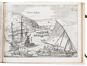
In den Warenkorb"Fretum le Maire" Double-page engraved chart. A detailed chart of the route taken by Jacob Le Maire and Willem Schouten from Porto Desire across the Pacific to New Guinea, with insets of their route along the north coast of New Guinea, and through the strait that was named for him: "Fretum le Maire", to the south of Tierra del F…uego. Published in Joris van Spilbergen's 'Speculum orientalis occidentalisque Indiae navigationum' (1619). In 1614 the VOC enjoined Spilbergen to sail with six vessels to the Moluccas via the Straits of Magellan. The five-year circumnavigation was the first carried out with the official support of the Dutch government. Although officially a trading mission, Spilbergen was authorised by the VOC to use force to disrupt the Spanish Pacific trade (Allen). Once the Seventeen Provinces had freed themselves from Spanish rule in 1581, they no longer had access to the Habsburg trading empire and needed to establish their own presence in the Pacific. Spilbergen himself believed that "the best and only means of reestablishing our affairs in the Indies and of making ourselves entirely masters of the Moluccas is, in my opinion, to dispatch a fleet and armada direct to the Philippines, in order to attack the Spaniards there, and to overpower all the places and strongholds it may be possible to conquer" (Zaide). After various mutinies and even more numerous acts of piracy, Spilbergen sailed through the Straits, he and his fleet captured and occupied Acapulco for a week, and then commenced their voyage across the Pacific in November of 1615. En route they discovered many islands, eventually reaching the Ladrones or Mariana Islands, and finally the Philippines where they spent a month raiding Manila-bound shipping, and the Dutch East Indies. There Spilbergen met up with Le Maire, who had discovered a new passage to the Pacific and had explored the Tuamotou Archipelago. Le Maire's voyages gave decisive evidence against the supposed existence of a massive southern continent and formed a catalyst to Tasman's discovery of New Zealand and Australia. Jacob Le Maire and Cornelis Schouten's voyage from Texel in June 1615, was a mission to find a new route to reach the Spices Islands which would break the trade monopoly of the VOC (which had been grant a monopoly trade through the Strait of Magellan). The pair succeeded by rounding South America south of the Straits of Magellan. The new cape was name "Horn" (or "Hoorn") after Shouten's ship which had been lost due to fire at the Patagonian port Desire. In doing so they also dispelled the myth of a great southern continent joined to South America. Le Maire and Schouten would continue to sail across the Pacific, discovering numerous islands along the way, and sailing up the northern coast of New Guinea. By September 1616 Le Maire reached Ternate in the Moluccas, the headquarters of the VOC. Initially well received, they were soon accused of having encroached on the rights of the Company and were tried, found guilty and shipped home on Spilbergen's ship which was completing its own trip around the world. Le Maire died on the return voyage and his journals were taken by the Company. Schouten and Spibergen published an abbreviated version of the journals; but it was not until 1622, after a long trial, that Isaac Le Maire was able to regain custody of his son's journals and to publish them in full. Provenance: Freycinet family archives Allen, 'North American Exploration: A New World Disclosed', 1997; Suarez, 'Early Mapping of Southeast Asia', 1999, pages 202-204; Zaide, 'Philippine Political and Cultural History: The Philippines since pre- Spanish Times', 1957.
 Weitere Bilder
Verlag: Chez Emanuel Colin de Thovoyon,, Amsterdam,, 1622
Anbieter: Daniel Crouch Rare Books Ltd, London, Vereinigtes KönigreichDaniel Crouch Rare Books Ltd
Verkäufer/-in kontaktierenVerkäufer/-in mit 4 SternenZustand: Gebraucht
EUR 307.849,33
EUR 23,44 VersandVersand von Vereinigtes Königreich nach USAAnzahl: 1 verfügbar
In den WarenkorbThe first town plan of anywhere in the present-day United States Folio (310 by 200mm), first French edition second issue (title page canncelled, with Paris imprint added to that of Amsterdam) engraved title with vignettes and map, [8], 103, [1, blank], [6], 107-254 pp., head- and tail-pieces, with decorated initials; 27 engraved… plates, pictorial title page, 17 maps and charts (16 double-page, 1 folded), 4 city views, 5 text engravings (scenes from Le Maire voyage), portrait of Le Maire not present as usual for the French edition, seventeenth century vellum. The first French edition of Herrera'a rare work here extra-illustrated with Boazio's exceedingly rare views of Santo Domingo (Dominican Republic); Santiago (Cape Verde Islands); Cartagena (Columbia); and San Augustine (Florida) - first known engraving of any locality in the present-day United States. The importance of this French edition of Herrera's 'Description des Indes Occidentales', and the other 1622 editions in Latin and Dutch, lies in its engraved pictorial title page with the first map to delineate California as an Island and in the inclusion of the first comprehensive account of Jacob Le Maire's voyage. The 14 maps in the Herrera's section are almost identical to those in the original 1601 'Descripcion', save for some resizing and changes in a few details. The most interesting are probably the 'Description de las Yndias Occidentalis', which depicts the Papal line of demarcation dividing the world between Spain and Portugal, and the 'Description de las Indias del Poniente', which depicts a large part of the Pacific with the Moluccas, the Philippines and the Ladrones accurately positioned. Le Maire and Cornelis Schouten, his second in command, left Texel in June 1615 on a mission to find a new route to reach the Spices Islands which would break the trade monopoly of the Dutch East India Company (which had been grant a monopoly trade through the Strait of Magellan). The pair succeeded to break the monopoly by rounding south America south of the Straits of Magellan. The new cape was name Horn (or Hoorn) after Shouten's ship which had been lost due to fire at the Patagonian port Desire. In doing so they also dispelled the myth of a great southern continent joined to South America. They would continue to sail across the Pacific, discovering numerous islands along the way, and sailing up the northern coast of New Guinea. By September 1616 Le Maire reached Ternate in the Moluccas, the headquarters of the Dutch East India Company. Initially well received, they were soon accused of having encroached on the rights of the Company and were tried, found guilty and shipped home on Spilbergen's ship which was completing its own trip around the world. Le Maire died on the return voyage and his journals were taken by the Company. Schouten and Spibergen published an abreviated version of these journal; and it was not until 1622, after a long trial, that Isaac Le Maire was able to regain custody of his son's journals and to publish them in full. The four additional city views (Santo Domingo in the Dominican Republic; Santiago in the Cape Verde Islands; Cartagena in Columbia; and San Augustine, Florida) were drawn, and possibly engraved, by the Italian artist Baptista Boazio. The Boazio views are "probably the most interesting and important published graphic work pertaining to Drake and his career" Kraus. They are also the first representations of those four cities. Indeed, the view of St Augustine is the first known engraving of any locality in the present-day United States. Their history is uncertain. There is no indication that Boazio participated to the voyage but he must have obtained a version of these views from someone who did: "It was undoubtedly in the course of the return voyage that the author of this view-plan [of St. Augustine] was able to copy the figure of the Dorado fish [and of the other creatures decorating the plans] from John White's original drawings" Kraus.
 Weitere Bilder
Verlag: Johannes Janssonius [printed by Izaak Elzevier?],, Amsterdam,, 1621
Anbieter: ASHER Rare Books, t Goy Houten, NiederlandeASHER Rare Books
Verkäufer/-in kontaktierenVerkäufer/-in mit 5 SternenZustand: Gebraucht
EUR 16.500,00
EUR 25,00 VersandVersand von Niederlande nach USAAnzahl: 1 verfügbar
In den WarenkorbFirst and only edition of the French translation of one of the bestsellers of illustrated 17th-century travel literature, describing one of the most famous early voyages around the world by Joris van Spilbergen (1568-1620), a veteran Dutch East Indies naval officer-turned-pirate, undertaken from 1614 to 1618. A short survey of a…nother of the most important early voyages around the world, by Schouten and Le Maire in the years 1615 to 1617, is added at the end (pp. 117-172) with drop-title "Navigationes Australes". It reports Le Maire's proof that Tierra del Fuego is an island and his discovery of what is still called the Strait of Le Maire, an alternative route to the Pacific. Rich in ethnographic detail, the numerous illustrations in the Miroir include oversized penguins, llamas and an Andean condor with a nine-foot wing span. Naval battles, beleaguered Spanish settlements, and newly discovered islands are also depicted in detail, making the work a valuable compendium of adventure on the high seas during the Age of Discovery.With several owner's inscriptions. With a few manuscript annotations in the margin. Lacking the world map. Washed with a brush, leaving light brown steaks on most leaves, and further with an occasional leaf foxed or smudged and an occasional minor tear. Otherwise a good copy of an extraordinary journal.l Borba de Moraes, p. 826 ("This French edition is much sought after"); Landwehr & V.d. Krogt, VOC 362; Sabin 89451; Tiele, Bibl. 1030. Modern vellum, sewn on 4 vellum tapes, with gold double fillets on the boards, gold lettering on the spine, gilt edges, green cloth ties. With 24 (of 25) engraved plates with maps, plans, views and battle-scenes, including 5 double-page and 10 larger folding (the large map of the Malayan archipelago with an inset-map of the Strait of Boeton, 32 x 45.5 cm). Pages: [4], 172 pp.


