Llsle (1 Ergebnisse)
- Karte
Anbieter: Tmecca Inc., Seoul, SüdkoreaTmecca Inc.
Verkäufer/-in kontaktierenVerkäufer/-in mit 2 SternenVerbandsmitglied: ILAB
Zustand: Gebraucht - Wie neu
EUR 360,91
EUR 17,51 VersandVersand von Südkorea nach USAAnzahl: 1 verfügbar
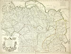
In den WarenkorbNo Binding. Zustand: As New. map of Tartary, consisting of the Eastern part of Russia, Central Asia, China and Korea, first published by Nicholas De L'Isle in 1706. The map extends from the Peninsula of Korea in the east to the Caspian and Black Seas. The Great Wall of China is shown, as is the Silk Route, many roads and remote…settlements, mountain ranges, rivers, etc. The wide swath of the Gobi Desert appears quite prominently, as does the Great Kingdom of Tibet, Cossack regions, the Country of the Mongols and many other features. De L'Isle was France's leading map maker in the early 18th Century and he and his heirs dominated the French map trade during most of the 18th Century.
