
Gesamtpreis (1 Artikel Artikel):
Versandziel:

lisle covens mortier (4 Ergebnisse)
Direkt zu den wichtigsten Suchergebnissen
Produktart
- Alle Product Types
- Bücher (3)
- Magazine & Zeitschriften
- Comics
- Noten
- Kunst, Grafik & Poster
- Fotografien
- Karten (1)
- Manuskripte & Papierantiquitäten
Zustand
- Alle
- Neu
- Antiquarisch (4)
Einband
- alle Einbände
- Hardcover
- Softcover
Weitere Eigenschaften
- Erstausgabe (1)
- Signiert
- Schutzumschlag
- Angebotsfoto (3)
Gratisversand
- Versand nach USA gratis
Land des Verkäufers
Verkäuferbewertung
-
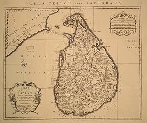
Carte de l'Isle de Ceylon. Insula Ceilon olim Taprobana
Verlag: Covens & Mortier, Amsterdam, 1740
Anbieter: Antipodean Books, Maps & Prints, ABAA, Garrison, NY, USA
Verbandsmitglied: ABAA ANZAAB ESA ILAB
Bewertung:

Large map focused on Ceylon, inclduing part of South East India. Copper engraved map, a beautiful impression in b&w, as issued. Magnificent cartouche. 57 x 48.5 cm.
-
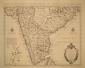
Carte des Cotes de Malabar et de Coromandel. Orarum Malabariae, Coromandelae &c. Tabula Accuratissima
Verlag: Covens & Mortier, Amsterdam, 1740
Anbieter: Antipodean Books, Maps & Prints, ABAA, Garrison, NY, USA
Verbandsmitglied: ABAA ANZAAB ESA ILAB
Bewertung:
Copper engraved map, a beautiful impression in b&w, as issued, very good condition. Handsome cartouche. 56.5 x 45.5 cm. India from the "Royaume de Bengala" in the north to Cap. Comorin, with half of Ceylon. Includes the "Les Laquedives ou Isles de Mamale" and the Isles Maldives.
-
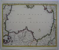
Seconde Partie de la Crimee la Mer Noire
Verlag: Jean Covens and Corneille Mortier, Amsterdam, 1720
Anbieter: Alexandre Antique Prints, Maps & Books, Toronto, ON, Kanada
Bewertung:

Karte
Zustand: Excellent. 18th century map of the black sea and turkey in fine outline colour. , Size : 490x615 (mm), 19.25x24.25 (Inches), Original Outline Coloring.
-

Carte de la Champagne et des Pays Voisins oů l'on voit la Generalité de Chalons, partie de celle de Soissons, &c. Par Guillaime De L'Isle de l'Académie Royale des Sciences. (antique map of Champagne)
Verlag: J. Covens et C. Mortier, Amsterdam, 1742
Anbieter: Cole & Contreras / Sylvan Cole Gallery, Sitges, BCN, Spanien
Bewertung:

Erstausgabe
A BEAUTIFUL HAND-COLORED MAP OF CHAMPAGNE and nearby areas. 48 x 63 cm (plate), 56 x 69 cm (sheet). The areas described in the title are FULLY COLORED BY A CONTEMPORARY HAND. Printed on fine, thick laid paper. Reverse blank. A fine impression. A few tiny marginal tears, else A PRISTINE EXAMPLE, with the paper FINE AND BRIGHT. Very scarce in such fine condition.
