Gesamtpreis (1 Artikel Artikel):
Versandziel:

letts thomas (252 Ergebnisse)
Direkt zu den wichtigsten Suchergebnissen
Suchfilter
Produktart
- Alle Product Types
- Bücher (35)
- Magazine & Zeitschriften (Keine weiteren Ergebnisse entsprechen dieser Verfeinerung)
- Comics (Keine weiteren Ergebnisse entsprechen dieser Verfeinerung)
- Noten (Keine weiteren Ergebnisse entsprechen dieser Verfeinerung)
- Kunst, Grafik & Poster (Keine weiteren Ergebnisse entsprechen dieser Verfeinerung)
- Fotografien (Keine weiteren Ergebnisse entsprechen dieser Verfeinerung)
- Karten (216)
- Manuskripte & Papierantiquitäten (1)
Zustand Mehr dazu
- Neu (Keine weiteren Ergebnisse entsprechen dieser Verfeinerung)
- Wie Neu, Sehr Gut oder Gut Bis Sehr Gut (4)
- Gut oder Befriedigend (222)
- Ausreichend oder Schlecht (Keine weiteren Ergebnisse entsprechen dieser Verfeinerung)
- Wie beschrieben (26)
Einband
Weitere Eigenschaften
- Erstausgabe (6)
- Signiert (Keine weiteren Ergebnisse entsprechen dieser Verfeinerung)
- Schutzumschlag (Keine weiteren Ergebnisse entsprechen dieser Verfeinerung)
- Angebotsfoto (245)
Sprache (2)
Gratisversand
Land des Verkäufers
Verkäuferbewertung
-

Short Story International (Student Series)
Sprache: Englisch
Verlag: International Cultural Exchange, Inc., 1994
ISBN 10: 1555731201 ISBN 13: 9781555731205
Anbieter: Better World Books: West, Reno, NV, USA
Verkäuferbewertung 5 von 5 Sternen

Zustand: Good. Pages intact with minimal writing/highlighting. The binding may be loose and creased. Dust jackets/supplements are not included. Stock photo provided. Product includes identifying sticker. Better World Books: Buy Books. Do Good.
-

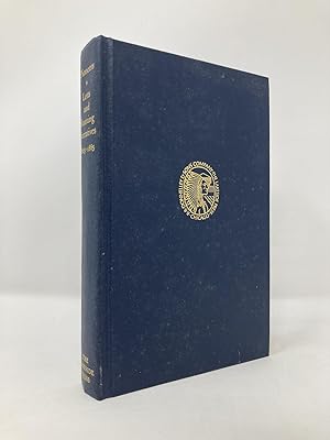
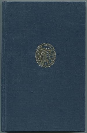
Pioneers;: Narratives of Noah Harris Letts and Thomas Allen Banning, 1825-1865 (Lakeside classics)
Verlag: Lakeside Press / R. R. Donnelley & Sons
Anbieter: ThriftBooks-Atlanta, AUSTELL, GA, USA
Verkäuferbewertung 5 von 5 Sternen
Hardcover. Zustand: Good. No Jacket. Pages can have notes/highlighting. Spine may show signs of wear. ~ ThriftBooks: Read More, Spend Less.
-
Pioneers: the Narratives of Noah Harris Letts and Thomas Allen Banning, 1825-1865
Verlag: Lakeside Press
Anbieter: Wonder Book, Frederick, MD, USA
Verkäuferbewertung 5 von 5 Sternen
Zustand: Very Good. Very Good condition. No Dust Jacket (American Frontier, Pioneer Life, History) A copy that may have a few cosmetic defects. May also contain a few markings such as an owner's name, short gifter's inscription or light stamp.
-

Pioneers: Narratives of Noah Harris Letts and Thomas Allen Banning 1825-1865
Verlag: The Lakeside Press, Chicago, IL, 1972
Anbieter: Jeff Hirsch Books, ABAA, Wadsworth, IL, USA
Verbandsmitglied: ABAA ILAB MWABA
Verkäuferbewertung 5 von 5 Sternen
Erstausgabe
First edition thus. Hardcover. 290 pages. The 70th entry in the longstanding series of books issued by the R.R. Donnelley & Sons Company as a Christmas gift for employees and friends of the press. Edited by Paul Angle. A near fine copy in blue cloth binding without dust jacket as issued. No dust jacket as issued.
-
Pioneers: Narratives of Noah Harris Letts and Thomas Allen Banning, 1825-1865
Verlag: Lakeside Press/R.R. Donnelley
Anbieter: Southampton Books, Sag Harbor, NY, USA
Verkäuferbewertung 5 von 5 Sternen
Erstausgabe
Hardcover. Zustand: Very Good. First Thus. First Edition Thus, First Printing. Published by Lakeside Press/R.R. Donnelley, 1972. Octavo. Blue cloth boards stamped in gold with gilt topstain. Book is very good; with no writing or names. Sharp corners and spine straight. Binding tight and pages crisp. Boards have light shelf wear with very light spotting to page ends. Book placed in custom acetate protector. 290 pages. 100% positive feedback. 30 day money back guarantee. NEXT DAY SHIPPING! Excellent customer service. Please email with any questions or if you would like a photo. All books packed carefully and ship with free delivery confirmation/tracking. All books come with free bookmarks. Ships from Southampton, New York. We Buy Books! Individual titles, libraries, collections. Message us if you have books to sell!
-
Pioneers: Narratives of Noah Harris Letts and Thomas Allen Banning, 1825-1865 (The Lakeside Classics)
Verlag: The Lakeside Press / R.R. Donnelley & Sons, Chicago, 1972
Anbieter: Between the Covers-Rare Books, Inc. ABAA, Gloucester City, NJ, USA
Verbandsmitglied: ABAA ESA ILAB IOBA
Verkäuferbewertung 5 von 5 Sternen
Hardcover. Zustand: Near Fine. Reprint. 290pp. Edited by Paul M. Angle. Spine slightly cocked, near fine without the dust jacket as issued.
-
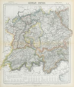
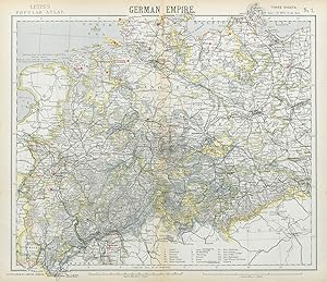
German Empire No 3
Erscheinungsdatum: 1889
Anbieter: Antiqua Print Gallery, London, Vereinigtes Königreich
Verkäuferbewertung 5 von 5 Sternen
Karte
EUR 4,72
EUR 11,46 Versand
Versand von Vereinigtes Königreich nach USAAnzahl: 1 verfügbar
In den WarenkorbZustand: Good. GERMANY SWITZERLAND AUSTRIA. Baden Württemberg Bavaria Tyrol. LETTS 1889 map. Antique colour atlas map; Published by Mason & Payne. Most of the plates used for this atlas were original engraved for the SDUK atlas in the mid nineteenth century. The plates were later sold to Thomas Letts, and subsequently to Mason & Payne (1889). 41.5 x 35.0cm, 16.25 x 13.75 inches. Condition: Good. The image shown may have been taken from a different example of this map than that which is offered for sale. The map you will receive is in good condition but there may be minor variations in the condition from that shown in the image. There is nothing printed on the reverse side, which is plain.
-
France No 3
Erscheinungsdatum: 1883
Anbieter: Antiqua Print Gallery, London, Vereinigtes Königreich
Verkäuferbewertung 5 von 5 Sternen
Karte
EUR 4,72
EUR 11,46 Versand
Versand von Vereinigtes Königreich nach USAAnzahl: 1 verfügbar
In den WarenkorbZustand: Good. FRANCE SOUTH. Lighthouses. UK-French trade 1876-1880. LETTS 1883 old map. Antique colour atlas map; Published by Letts & Co. Most of the plates used for this atlas were original engraved for the SDUK atlas in the mid nineteenth century. The plates were later sold to Thomas Letts, and subsequently to Mason & Payne (1883). 36.5 x 44.0cm, 14.25 x 17.25 inches; this is a folding map. Condition: Good. The image shown may have been taken from a different example of this map than that which is offered for sale. The map you will receive is in good condition but there may be minor variations in the condition from that shown in the image. There is nothing printed on the reverse side, which is plain.
-
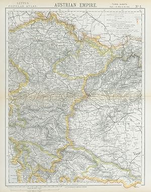
Austrian Empire No 1
Erscheinungsdatum: 1883
Anbieter: Antiqua Print Gallery, London, Vereinigtes Königreich
Verkäuferbewertung 5 von 5 Sternen
Karte
EUR 4,72
EUR 11,46 Versand
Versand von Vereinigtes Königreich nach USAAnzahl: 2 verfügbar
In den WarenkorbZustand: Good. AUSTRIAN EMPIRE. Bohemia Moravia Styria Illyria Croatia Hungary. LETTS 1883 map. Antique colour atlas map; Published by Letts & Co. Most of the plates used for this atlas were original engraved for the SDUK atlas in the mid nineteenth century. The plates were later sold to Thomas Letts, and subsequently to Mason & Payne (1883). 43.5 x 34.0cm, 17 x 13.5 inches; this is a folding map. Condition: Good. The image shown may have been taken from a different example of this map than that which is offered for sale. The map you will receive is in good condition but there may be minor variations in the condition from that shown in the image. There is nothing printed on the reverse side, which is plain.
-
France No 2
Erscheinungsdatum: 1889
Anbieter: Antiqua Print Gallery, London, Vereinigtes Königreich
Verkäuferbewertung 5 von 5 Sternen
Karte
EUR 4,72
EUR 11,46 Versand
Versand von Vereinigtes Königreich nach USAAnzahl: 2 verfügbar
In den WarenkorbZustand: Good. NE FRANCE w/o Alsace Lorraine. Champagne Picardy Burgundy Nord.LETTS 1889 map. Antique colour atlas map; Published by Mason & Payne. Most of the plates used for this atlas were original engraved for the SDUK atlas in the mid nineteenth century. The plates were later sold to Thomas Letts, and subsequently to Mason & Payne (1889). 42.5 x 32.0cm, 16.5 x 12.5 inches. Condition: Good. The image shown may have been taken from a different example of this map than that which is offered for sale. The map you will receive is in good condition but there may be minor variations in the condition from that shown in the image. There is nothing printed on the reverse side, which is plain.
-
France No 3
Erscheinungsdatum: 1884
Anbieter: Antiqua Print Gallery, London, Vereinigtes Königreich
Verkäuferbewertung 5 von 5 Sternen
Karte
EUR 4,72
EUR 11,46 Versand
Versand von Vereinigtes Königreich nach USAAnzahl: 1 verfügbar
In den WarenkorbZustand: Good. FRANCE SOUTH. Lighthouses. UK-French trade 1876-1880. LETTS 1884 old map. Antique colour atlas map; Published by Letts & Co. Most of the plates used for this atlas were original engraved for the SDUK atlas in the mid nineteenth century. The plates were later sold to Thomas Letts, and subsequently to Mason & Payne (1884). 36.0 x 43.0cm, 14.25 x 17 inches. Condition: Good. Tight top margin; The image shown may have been taken from a different example of this map than that which is offered for sale. The map you will receive is in good condition but there may be minor variations in the condition from that shown in the image. There is nothing printed on the reverse side, which is plain.
-
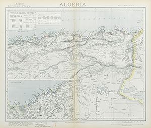
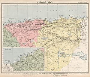
Algeria; Inset map of Continuation Algeria
Erscheinungsdatum: 1883
Anbieter: Antiqua Print Gallery, London, Vereinigtes Königreich
Verkäuferbewertung 5 von 5 Sternen
Karte
EUR 4,72
EUR 11,46 Versand
Versand von Vereinigtes Königreich nach USAAnzahl: 1 verfügbar
In den WarenkorbZustand: Good. ALGERIA. North Africa. Algiers Oran Constantine. British Consuls. LETTS 1883 map. Antique colour atlas map; Published by Letts & Co. Most of the plates used for this atlas were original engraved for the SDUK atlas in the mid nineteenth century. The plates were later sold to Thomas Letts, and subsequently to Mason & Payne (1883). 36.0 x 42.5cm, 14.25 x 16.75 inches; this is a folding map. Condition: Good. The image shown may have been taken from a different example of this map than that which is offered for sale. The map you will receive is in good condition but there may be minor variations in the condition from that shown in the image. There is nothing printed on the reverse side, which is plain.
-
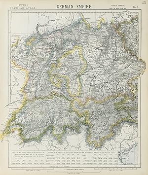
German Empire No 3
Erscheinungsdatum: 1883
Anbieter: Antiqua Print Gallery, London, Vereinigtes Königreich
Verkäuferbewertung 5 von 5 Sternen
Karte
EUR 4,72
EUR 11,46 Versand
Versand von Vereinigtes Königreich nach USAAnzahl: 1 verfügbar
In den WarenkorbZustand: Good. SOUTH GERMANY SWITZERLAND AUSTRIA Baden Württemberg Bavaria Tyrol 1883 old map. Antique colour atlas map; Published by Letts & Co. Most of the plates used for this atlas were original engraved for the SDUK atlas in the mid nineteenth century. The plates were later sold to Thomas Letts, and subsequently to Mason & Payne (1883). 43.0 x 36.5cm, 17 x 14.5 inches; this is a folding map. Condition: Good. The image shown may have been taken from a different example of this map than that which is offered for sale. The map you will receive is in good condition but there may be minor variations in the condition from that shown in the image. There is nothing printed on the reverse side, which is plain.
-
Algeria; Inset map of Continuation Algeria
Erscheinungsdatum: 1889
Anbieter: Antiqua Print Gallery, London, Vereinigtes Königreich
Verkäuferbewertung 5 von 5 Sternen
Karte
EUR 4,72
EUR 11,46 Versand
Versand von Vereinigtes Königreich nach USAAnzahl: 1 verfügbar
In den WarenkorbZustand: Good. ALGERIA. North Africa. Algier Algiers Oran Constantine. LETTS 1889 old map. Antique colour atlas map; Published by Mason & Payne. Most of the plates used for this atlas were original engraved for the SDUK atlas in the mid nineteenth century. The plates were later sold to Thomas Letts, and subsequently to Mason & Payne (1889). 34.5 x 40.5cm, 13.5 x 16 inches. Condition: Good. The image shown may have been taken from a different example of this map than that which is offered for sale. The map you will receive is in good condition but there may be minor variations in the condition from that shown in the image. There is nothing printed on the reverse side, which is plain.
-
Canada No 2
Erscheinungsdatum: 1889
Anbieter: Antiqua Print Gallery, London, Vereinigtes Königreich
Verkäuferbewertung 5 von 5 Sternen
Karte
EUR 4,72
EUR 11,46 Versand
Versand von Vereinigtes Königreich nach USAAnzahl: 2 verfügbar
In den WarenkorbZustand: Good. QUEBEC Québec. St Lawrence lighthouses. Maine.New Brunswick.LETTS 1889 old map. Antique colour atlas map; Published by Mason & Payne. Most of the plates used for this atlas were original engraved for the SDUK atlas in the mid nineteenth century. The plates were later sold to Thomas Letts, and subsequently to Mason & Payne (1889). 35.0 x 41.0cm, 13.75 x 16.25 inches. Condition: Good. The image shown may have been taken from a different example of this map than that which is offered for sale. The map you will receive is in good condition but there may be minor variations in the condition from that shown in the image. There is nothing printed on the reverse side, which is plain.
-
German Empire No 3
Erscheinungsdatum: 1884
Anbieter: Antiqua Print Gallery, London, Vereinigtes Königreich
Verkäuferbewertung 5 von 5 Sternen
Karte
EUR 4,72
EUR 11,46 Versand
Versand von Vereinigtes Königreich nach USAAnzahl: 1 verfügbar
In den WarenkorbZustand: Good. SOUTH GERMANY SWITZERLAND AUSTRIA Baden Württemberg Bavaria Tyrol 1884 old map. Antique colour atlas map; Published by Letts & Co. Most of the plates used for this atlas were original engraved for the SDUK atlas in the mid nineteenth century. The plates were later sold to Thomas Letts, and subsequently to Mason & Payne (1884). 43.0 x 36.5cm, 17 x 14.25 inches. Condition: Good. The image shown may have been taken from a different example of this map than that which is offered for sale. The map you will receive is in good condition but there may be minor variations in the condition from that shown in the image. There is nothing printed on the reverse side, which is plain.
-
Austrian Empire No 1
Erscheinungsdatum: 1884
Anbieter: Antiqua Print Gallery, London, Vereinigtes Königreich
Verkäuferbewertung 5 von 5 Sternen
Karte
EUR 4,72
EUR 11,46 Versand
Versand von Vereinigtes Königreich nach USAAnzahl: 1 verfügbar
In den WarenkorbZustand: Good. AUSTRIAN EMPIRE. Bohemia Moravia Styria Illyria Croatia Hungary. LETTS 1884 map. Antique colour atlas map; Published by Letts & Co. Most of the plates used for this atlas were original engraved for the SDUK atlas in the mid nineteenth century. The plates were later sold to Thomas Letts, and subsequently to Mason & Payne (1884). 43.5 x 33.5cm, 17 x 13.25 inches. Condition: Good. The image shown may have been taken from a different example of this map than that which is offered for sale. The map you will receive is in good condition but there may be minor variations in the condition from that shown in the image. There is nothing printed on the reverse side, which is plain.
-
Pioneers: Narratives of Noah Harris Letts and Thomas Allen Banning, 1825-1865
Verlag: R.R. Donnelley & Sons Company, Chicago, 1972
Anbieter: Main Street Fine Books & Mss, ABAA, Galena, IL, USA
Verbandsmitglied: ABAA ILAB MWABA
Verkäuferbewertung 5 von 5 Sternen
Hardcover. Edited by Paul M. Angle. 16mo. Blue cloth with gilt spine lettering and decoration. xxii, 290pp. Top edge gilt. Maps, illustrations. Very good. 70th volume in the "Lakeside Classics" series of annual Christmas keepsakes, largely reprints of rare historical texts. Two pioneering Illinoisan memoirs, published here for the first time.
-
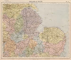
England and Wales No 4
Erscheinungsdatum: 1889
Anbieter: Antiqua Print Gallery, London, Vereinigtes Königreich
Verkäuferbewertung 5 von 5 Sternen
Karte
EUR 5,90
EUR 11,46 Versand
Versand von Vereinigtes Königreich nach USAAnzahl: 1 verfügbar
In den WarenkorbZustand: Good. ENGLAND EAST. Lighthouses East Midlands East Anglia Lincolnshire. LETTS 1889 map. Antique colour atlas map; Published by Mason & Payne. Most of the plates used for this atlas were original engraved for the SDUK atlas in the mid nineteenth century. The plates were later sold to Thomas Letts, and subsequently to Mason & Payne (1889). 34.5 x 41.0cm, 13.5 x 16 inches. Condition: Good. The image shown may have been taken from a different example of this map than that which is offered for sale. The map you will receive is in good condition but there may be minor variations in the condition from that shown in the image. There is nothing printed on the reverse side, which is plain.
-
Russia No.4
Erscheinungsdatum: 1884
Anbieter: Antiqua Print Gallery, London, Vereinigtes Königreich
Verkäuferbewertung 5 von 5 Sternen
Karte
EUR 5,90
EUR 11,46 Versand
Versand von Vereinigtes Königreich nach USAAnzahl: 1 verfügbar
In den WarenkorbZustand: Good. RUSSIA Moscow-St Petersburg. Novgorod Smolensk Vologda Iarolslav LETTS 1884 map. Antique colour atlas map; Published by Letts & Co. Most of the plates used for this atlas were original engraved for the SDUK atlas in the mid nineteenth century. The plates were later sold to Thomas Letts, and subsequently to Mason & Payne (1884). 36.5 x 43.5cm, 14.25 x 17 inches. Condition: Good. Tight bottom margin below caption; Tight top margin; The image shown may have been taken from a different example of this map than that which is offered for sale. The map you will receive is in good condition but there may be minor variations in the condition from that shown in the image. There is nothing printed on the reverse side, which is plain.
-
Canada No 2
Erscheinungsdatum: 1883
Anbieter: Antiqua Print Gallery, London, Vereinigtes Königreich
Verkäuferbewertung 5 von 5 Sternen
Karte
EUR 5,90
EUR 11,46 Versand
Versand von Vereinigtes Königreich nach USAAnzahl: 2 verfügbar
In den WarenkorbZustand: Good. QUEBEC Québec. St Lawrence lighthouses. Maine. New Brunswick. LETTS 1883 map. Antique colour atlas map; Published by Letts & Co. Most of the plates used for this atlas were original engraved for the SDUK atlas in the mid nineteenth century. The plates were later sold to Thomas Letts, and subsequently to Mason & Payne (1883). 36.5 x 43.0cm, 14.25 x 17 inches; this is a folding map. Condition: Good. The image shown may have been taken from a different example of this map than that which is offered for sale. The map you will receive is in good condition but there may be minor variations in the condition from that shown in the image. There is nothing printed on the reverse side, which is plain.
-
Statistical map of Scotland No. 1
Erscheinungsdatum: 1883
Anbieter: Antiqua Print Gallery, London, Vereinigtes Königreich
Verkäuferbewertung 5 von 5 Sternen
Karte
EUR 5,90
EUR 11,46 Versand
Versand von Vereinigtes Königreich nach USAAnzahl: 1 verfügbar
In den WarenkorbZustand: Good. SCOTLAND SOUTH. Railways lighthouses lifeboat stations. LETTS 1883 old map. Antique colour atlas map; Published by Letts & Co. Most of the plates used for this atlas were original engraved for the SDUK atlas in the mid nineteenth century. The plates were later sold to Thomas Letts, and subsequently to Mason & Payne (1883). 33.5 x 42.0cm, 13 x 16.5 inches; this is a folding map. Condition: Good. The image shown may have been taken from a different example of this map than that which is offered for sale. The map you will receive is in good condition but there may be minor variations in the condition from that shown in the image. There is nothing printed on the reverse side, which is plain.
-
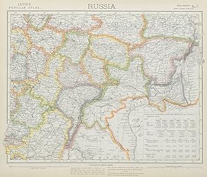
Russia No.7
Erscheinungsdatum: 1883
Anbieter: Antiqua Print Gallery, London, Vereinigtes Königreich
Verkäuferbewertung 5 von 5 Sternen
Karte
EUR 6,50
EUR 11,46 Versand
Versand von Vereinigtes Königreich nach USAAnzahl: 2 verfügbar
In den WarenkorbZustand: Good. RUSSIA Astrakhan Kostroma Viatra Perm Penza Saratov Kazan Tambor LETTS 1883 map. Antique colour atlas map; Published by Letts & Co. Most of the plates used for this atlas were original engraved for the SDUK atlas in the mid nineteenth century. The plates were later sold to Thomas Letts, and subsequently to Mason & Payne (1883). 36.5 x 43.0cm, 14.25 x 17 inches; this is a folding map. Condition: Good. The image shown may have been taken from a different example of this map than that which is offered for sale. The map you will receive is in good condition but there may be minor variations in the condition from that shown in the image. There is nothing printed on the reverse side, which is plain.
-
German Empire No 1
Erscheinungsdatum: 1883
Anbieter: Antiqua Print Gallery, London, Vereinigtes Königreich
Verkäuferbewertung 5 von 5 Sternen
Karte
EUR 6,50
EUR 11,46 Versand
Versand von Vereinigtes Königreich nach USAAnzahl: 2 verfügbar
In den WarenkorbZustand: Good. GERMAN EMPIRE. Prussian Provinces. Lighthouses. British consuls. LETTS 1883 map. Antique colour atlas map; Published by Letts & Co. Most of the plates used for this atlas were original engraved for the SDUK atlas in the mid nineteenth century. The plates were later sold to Thomas Letts, and subsequently to Mason & Payne (1883). 36.5 x 42.5cm, 14.5 x 16.75 inches; this is a folding map. Condition: Good. The image shown may have been taken from a different example of this map than that which is offered for sale. The map you will receive is in good condition but there may be minor variations in the condition from that shown in the image. There is nothing printed on the reverse side, which is plain.
-
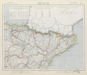
Spain No 2
Erscheinungsdatum: 1889
Anbieter: Antiqua Print Gallery, London, Vereinigtes Königreich
Verkäuferbewertung 5 von 5 Sternen
Karte
EUR 6,50
EUR 11,46 Versand
Versand von Vereinigtes Königreich nach USAAnzahl: 1 verfügbar
In den WarenkorbZustand: Good. SPAIN NORTH EAST. Catalonia Aragon Navarra. Railways Lighthouses. LETTS 1889 map. Antique colour atlas map; Published by Mason & Payne. Most of the plates used for this atlas were original engraved for the SDUK atlas in the mid nineteenth century. The plates were later sold to Thomas Letts, and subsequently to Mason & Payne (1889). 33.5 x 39.0cm, 13 x 15.25 inches. Condition: Good. The image shown may have been taken from a different example of this map than that which is offered for sale. The map you will receive is in good condition but there may be minor variations in the condition from that shown in the image. There is nothing printed on the reverse side, which is plain.
-
German Empire No 1
Erscheinungsdatum: 1884
Anbieter: Antiqua Print Gallery, London, Vereinigtes Königreich
Verkäuferbewertung 5 von 5 Sternen
Karte
EUR 6,50
EUR 11,46 Versand
Versand von Vereinigtes Königreich nach USAAnzahl: 1 verfügbar
In den WarenkorbZustand: Good. GERMAN EMPIRE. Prussian Provinces. Lighthouses. British consuls. LETTS 1884 map. Antique colour atlas map; Published by Letts & Co. Most of the plates used for this atlas were original engraved for the SDUK atlas in the mid nineteenth century. The plates were later sold to Thomas Letts, and subsequently to Mason & Payne (1884). 36.5 x 42.5cm, 14.25 x 16.75 inches. Condition: Good. The image shown may have been taken from a different example of this map than that which is offered for sale. The map you will receive is in good condition but there may be minor variations in the condition from that shown in the image. There is nothing printed on the reverse side, which is plain.
-
Spain No.2
Erscheinungsdatum: 1883
Anbieter: Antiqua Print Gallery, London, Vereinigtes Königreich
Verkäuferbewertung 5 von 5 Sternen
Karte
EUR 6,50
EUR 11,46 Versand
Versand von Vereinigtes Königreich nach USAAnzahl: 2 verfügbar
In den WarenkorbZustand: Good. SPAIN NORTH EAST. Catalonia Aragon Navarra. Railways Lighthouses. LETTS 1883 map. Antique colour atlas map; Published by Letts & Co. Most of the plates used for this atlas were original engraved for the SDUK atlas in the mid nineteenth century. The plates were later sold to Thomas Letts, and subsequently to Mason & Payne (1883). 35.5 x 42.0cm, 14 x 16.5 inches; this is a folding map. Condition: Good. The image shown may have been taken from a different example of this map than that which is offered for sale. The map you will receive is in good condition but there may be minor variations in the condition from that shown in the image. There is nothing printed on the reverse side, which is plain.
-
Denmark and South Norway
Erscheinungsdatum: 1889
Anbieter: Antiqua Print Gallery, London, Vereinigtes Königreich
Verkäuferbewertung 5 von 5 Sternen
Karte
EUR 6,50
EUR 11,46 Versand
Versand von Vereinigtes Königreich nach USAAnzahl: 1 verfügbar
In den WarenkorbZustand: Good. SCANDINAVIA. Denmark & Southern Norway. Lighthouses Railways. LETTS 1889 map. Antique colour atlas map; Published by Mason & Payne. Most of the plates used for this atlas were original engraved for the SDUK atlas in the mid nineteenth century. The plates were later sold to Thomas Letts, and subsequently to Mason & Payne (1889). 42.5 x 32.5cm, 16.75 x 12.75 inches. Condition: Good. The image shown may have been taken from a different example of this map than that which is offered for sale. The map you will receive is in good condition but there may be minor variations in the condition from that shown in the image. There is nothing printed on the reverse side, which is plain.
-
Spain No.2
Erscheinungsdatum: 1884
Anbieter: Antiqua Print Gallery, London, Vereinigtes Königreich
Verkäuferbewertung 5 von 5 Sternen
Karte
EUR 6,50
EUR 11,46 Versand
Versand von Vereinigtes Königreich nach USAAnzahl: 1 verfügbar
In den WarenkorbZustand: Good. SPAIN NORTH EAST. Catalonia Aragon Navarra. Railways Lighthouses. LETTS 1884 map. Antique colour atlas map; Published by Letts & Co. Most of the plates used for this atlas were original engraved for the SDUK atlas in the mid nineteenth century. The plates were later sold to Thomas Letts, and subsequently to Mason & Payne (1884). 35.0 x 40.5cm, 13.75 x 16 inches. Condition: Good. The image shown may have been taken from a different example of this map than that which is offered for sale. The map you will receive is in good condition but there may be minor variations in the condition from that shown in the image. There is nothing printed on the reverse side, which is plain.
-
Russia No.7
Erscheinungsdatum: 1884
Anbieter: Antiqua Print Gallery, London, Vereinigtes Königreich
Verkäuferbewertung 5 von 5 Sternen
Karte
EUR 6,50
EUR 11,46 Versand
Versand von Vereinigtes Königreich nach USAAnzahl: 1 verfügbar
In den WarenkorbZustand: Good. RUSSIA Astrakhan Kostroma Viatra Perm Penza Saratov Kazan Tambor LETTS 1884 map. Antique colour atlas map; Published by Letts & Co. Most of the plates used for this atlas were original engraved for the SDUK atlas in the mid nineteenth century. The plates were later sold to Thomas Letts, and subsequently to Mason & Payne (1884). 36.0 x 42.0cm, 14.25 x 16.5 inches. Condition: Good. The image shown may have been taken from a different example of this map than that which is offered for sale. The map you will receive is in good condition but there may be minor variations in the condition from that shown in the image. There is nothing printed on the reverse side, which is plain.