
Gesamtpreis (1 Artikel Artikel):
Versandziel:

laurie richard holmes spencer nathaniel (1 Ergebnisse)
Feedback
Direkt zu den wichtigsten Suchergebnissen
Suchfilter
Produktart
- Alle Product Types
- Bücher (Keine weiteren Ergebnisse entsprechen dieser Verfeinerung)
- Magazine & Zeitschriften (Keine weiteren Ergebnisse entsprechen dieser Verfeinerung)
- Comics (Keine weiteren Ergebnisse entsprechen dieser Verfeinerung)
- Noten (Keine weiteren Ergebnisse entsprechen dieser Verfeinerung)
- Kunst, Grafik & Poster (Keine weiteren Ergebnisse entsprechen dieser Verfeinerung)
- Fotografien (Keine weiteren Ergebnisse entsprechen dieser Verfeinerung)
- Karten (1)
- Manuskripte & Papierantiquitäten (Keine weiteren Ergebnisse entsprechen dieser Verfeinerung)
Zustand
- Alle
- Neu (Keine weiteren Ergebnisse entsprechen dieser Verfeinerung)
- Antiquarisch (1)
Einband
- alle Einbände
- Hardcover (Keine weiteren Ergebnisse entsprechen dieser Verfeinerung)
- Softcover (Keine weiteren Ergebnisse entsprechen dieser Verfeinerung)
Weitere Eigenschaften
- Erstausgabe (Keine weiteren Ergebnisse entsprechen dieser Verfeinerung)
- Signiert (Keine weiteren Ergebnisse entsprechen dieser Verfeinerung)
- Schutzumschlag (Keine weiteren Ergebnisse entsprechen dieser Verfeinerung)
- Angebotsfoto (1)
Gratisversand
- Kostenloser Versand nach Deutschland (Keine weiteren Ergebnisse entsprechen dieser Verfeinerung)
Verkäuferbewertung
-
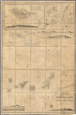
Chart of the Canary Islands, with Madeira, Porto-Santo, &c.
Verlag: LondonR.H. Laurie No. 53. Fleet Street June 30 ., 1842
Anbieter: Robert Frew Ltd. ABA ILAB, London, Vereinigtes Königreich
Verbandsmitglied: ABA ILAB PBFA
Verkäuferbewertung 4 von 5 Sternen

Karte
ANNOTATED ONBOARD A CONTEMPORARY VOYAGE. Original engraved folding map (100 x 66.5 cm) depicting the Canary Islands, Madeira and part of the West Coast of Africa, incorporating five inset maps of the Islands of Madeira, the Island of Porto Santo, the Road of Funchal, the Roadstead of Santa-Cruz, and Great Salvage, tohether with five engraved coastal landscape profiles of Funchal and the South Madeira, Porto Santo, Allegranza, the Island of Palma, Tenerife from the South-West, and the Isleta of the Grand Canary. Copiously annotated with printed notations of settlements, landmarks, references to other maps and books, and navigational aids ("good anchorage", "strong current", "Shell fish abundant", "Pyramid, a high Rock frequently mistaken for a large Ship under sail", "Beware of approaching too near the coast hereabout, lest the Current set you aground on the Flat, and you fall, enslaved, into the hands of the Arabs"). Additionally annotated with detailed manuscript notes written in fine blue ink relating to a two-part voyage made in 1844 aboard the Brig 'Vernon' and the Schoone 'Admiral Colpoys'. A very good copy of a map which has seen active service, with old damp marking throughout and a little creasing to the bottom corners. A splendid engraved map of the Canary Islands, meticulously annotated during a contemporary voyage. Clearly used as a navigational aid, the annotations carefully chart the progress of a two-part voyage from Porto Santo, Madeira, via Funchal, to Santa Cruz, Tenerife. First describing the progress of the initial leg from Porto Santo to Madeira (31st January - 2nd February 1844) onboard the Brig 'Vernon', under Captain Webster, they go on to summarise the final leg from Funchal, Madeira to Santa Cruz, Tenerife, via the Schooner the 'Admiral Colpoys', commanded by Nathaniel Spencer: "19th October 1844. - Schooner 'Admiral Colpoys', Nathl. Spencer Commdr., from Madeira to Teneriffe. At 1 p.m. made sail at Noon on 20th Lat. 30. 33. 25 Miles Northward of the Great Salvage. At 1 p.m. Gt. Salvage S. by E. 20 miles. At 7 p.m. passed the Southern Salvage. At Daylight 21st saw the Eastend of Tenerife. At Noon East End South Distant about 4 Leagues. At 5.30 p.m. Dropped anchor in the Roadstead of Santa Cruz". Each leg of the voyage is also accurately recorded on the map using neat ruled lines in blue ink. The manuscript annotations additionally comment on the map's accuracy, mark further settlements and correct information such as population statistics, noting, for example, beside the island of South Deserta: "Population according to Wyld's Chart, 600. Incorrect. No constant residents. A few fishermen occasionally resort there for a few months in the year and scarcely amount to fifty in number". In another significant intervention, the annotator also asserts that in the map's panorama of Funchal, the "mountains [are] scarcely lofty enough in proportion to the space occupied by the town", with the mountains' summits diligently re-drawn in ink. On the inset map depicting Porto Santo, the mooring of the 'Vernon' off the island's coast is denoted by way of a small hand-drawn ship, which is also accompanied by an inland route noting the location of "water", and there is a further hand-drawn inland route on the island of Madeira, which additionally notes elevations and additional settlements/landmarks. The Canary Islands were a popular port of call for ships travelling between Europe and the Americas, with some transporting the islands' own products such as cochineal, sugarcane and rum to be sold in American ports such as Veracruz, Campeche, La Guaira and Havana. An evocative map, having seen active service aboard (at least) two contemporary voyages within the Canary Islands. Scarcity: Only one institutional copy recorded worldwide according to WorldCat (British Library).