
Gesamtpreis (1 Artikel Artikel):
Versandziel:

langenes barent (94 Ergebnisse)
Direkt zu den wichtigsten Suchergebnissen
Suchfilter
Produktart
- Alle Product Types
- Bücher (4)
- Magazine & Zeitschriften (Keine weiteren Ergebnisse entsprechen dieser Verfeinerung)
- Comics (Keine weiteren Ergebnisse entsprechen dieser Verfeinerung)
- Noten (Keine weiteren Ergebnisse entsprechen dieser Verfeinerung)
- Kunst, Grafik & Poster (Keine weiteren Ergebnisse entsprechen dieser Verfeinerung)
- Fotografien (Keine weiteren Ergebnisse entsprechen dieser Verfeinerung)
- Karten (90)
- Manuskripte & Papierantiquitäten (Keine weiteren Ergebnisse entsprechen dieser Verfeinerung)
Zustand Mehr dazu
- Neu (1)
- Wie Neu, Sehr Gut oder Gut Bis Sehr Gut (Keine weiteren Ergebnisse entsprechen dieser Verfeinerung)
- Gut oder Befriedigend (4)
- Ausreichend oder Schlecht (Keine weiteren Ergebnisse entsprechen dieser Verfeinerung)
- Wie beschrieben (89)
Einband
- alle Einbände
- Hardcover (1)
- Softcover (Keine weiteren Ergebnisse entsprechen dieser Verfeinerung)
Weitere Eigenschaften
- Erstausgabe (53)
- Signiert (Keine weiteren Ergebnisse entsprechen dieser Verfeinerung)
- Schutzumschlag (Keine weiteren Ergebnisse entsprechen dieser Verfeinerung)
- Angebotsfoto (92)
Sprache (3)
Gratisversand
- Kostenloser Versand nach USA (Keine weiteren Ergebnisse entsprechen dieser Verfeinerung)
Land des Verkäufers
Verkäuferbewertung
-

Caert-thresoor, inhoudende de tafelen des gantsche werelts landen met beschryvingen verlicht . 1598
Anbieter: Majestic Books, Hounslow, Vereinigtes Königreich
Verkäuferbewertung 4 von 5 Sternen

EUR 34,44
EUR 7,45 Versand
Versand von Vereinigtes Königreich nach USAAnzahl: 4 verfügbar
In den WarenkorbZustand: New. pp. 675.
-

Insulae Canariae ol: Fortunatae / d'Eylanden van Canarien
Anbieter: Antiquariat Lang, Rennerod, Deutschland
Verkäuferbewertung 4 von 5 Sternen
Handkolorierter Orig.-Kupferstich. ( Thresor de Chartes, um 1600 ). - Motiv: 8,3 x 12 auf Blatt: 10,8 x 15,8. * Diese Karte der Kanarischen Inseln enthält einen Ausschnitt des Hafens von Las Palmas (links oben), der ein Zwischenstopp für die spanischen Eroberer, Händler und Missionare auf ihrem Weg in die Neue Welt war. Niederländischer Text auf der Rückseite. Die Karte wurde erstmals von Cornelius Claesz veröffentlicht und von Barent Langenes in der Ausgabe von 1598 gedruckt. - This map of the Canary Islands includes an inset of the Port of Las Palmas, a stopping point for the Spanish conquerors, traders, and missionaries on their way to the New World. Netherlands text on verso. The map was first published by Cornelius Claesz and printed by Barent Langenes in the 1598 edition. - References: King (2nd ed.) pp. 80-82; Van der Krogt (Vol. III) #8970:341.
-
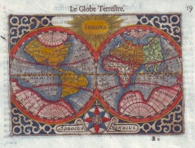
Le Globe Terrestre (alter, handkolorierter Kupferstich).
Sprache: Französisch
Verlag: ohne Jahresangabe (ca. 1590)., 1590
Anbieter: Antiquariat ExLibris Erlach Eberhard Ott, Ochsenfurt - Erlach, BY, Deutschland
Verbandsmitglied: GIAQ
Verkäuferbewertung 5 von 5 Sternen

Alter, handkolorierter Kupferstich aus Thresor De Chartes, Contenant Les Tableaux De Tous Les Pays Du Monde : enrichi de belles descriptions, reveu & augmenté Autor / Hrsg.: Langenes, Barent ; Claesz, Cornelis ; La Haye, Jean de ; Langenes, Barent ; Claesz, Cornelis ; La Haye, Jean de Verlagsort: [Amsterdam] | Erscheinungsjahr: 1602 | Verlag: Christoffle Guyot. Hier auch Stiche von Pieter van der Keere (Petrus Kaerius / Kerius), Rückseite paginiert und mit Text bedruckt "Description du Globe Terrestre". Handgeschöpftes Büttenpapier. Blatt professionell gereinigt und nachkoloriert. Professionell gerahmt mit Passepartout. Zahlreiche weitere Detailkarten (noch ungerahmt) verfügbar, z.B. Europe, Poloigne, Asie, Afrique, Le nouveau Monde, Engleterre (Anglia), Cambria ou Wallia, Escosse (Scotia), Irlande (Hibernia), Espaigne (Hispania), Valence (Valentia), Calis Malis (Baia de Cadiz), Mallorque & Minorque (Majorca, Minorca), Portugal (Portugallia). Abbildungen auf Anfrage. wikipedia Pieter van den Keere, ou Petrus Kaerius en latin, est un graveur et cartographe néerlandais né en 1571 ŕ Gand et mort en 1646 ŕ 75 ans. Sprache: Französisch Gewicht in Gramm: 1001 Blattgröße 12 x18, Bild 8,5 x 12,3 cm. Thresor de Chartes, contenant les tableaux de tous les pays du monde, enrichi de belles descriptions, entre 1598 et 1602.
-

I. S. Lauretij
Verlag: Antwerp, 1599
Anbieter: Clive A. Burden Ltd., Chalfont St. Giles, BUCKS, Vereinigtes Königreich
Verkäuferbewertung 5 von 5 Sternen
Karte
EUR 112,11
EUR 25,38 Versand
Versand von Vereinigtes Königreich nach USAAnzahl: 1 verfügbar
In den WarenkorbNo binding. 90 x 120 mm., in good condition. This fine early map of Madagascar is orientated with the east at the top. It is finely engraved by Benjamin Wright to replace the plate in Barent Langenes's original 'Caert-Thresoor' of 1598. This version was used in subsequent editions published by Claesz starting in 1599, this example is from the 1609 with Dutch text to the verso. Van der Krogt, P. (Atlantes) 8900:341B.
-
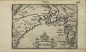
Bengala
Verlag: Amsterdam, 1598
Anbieter: Clive A. Burden Ltd., Chalfont St. Giles, BUCKS, Vereinigtes Königreich
Verkäuferbewertung 5 von 5 Sternen
Karte
EUR 129,81
EUR 25,38 Versand
Versand von Vereinigtes Königreich nach USAAnzahl: 1 verfügbar
In den WarenkorbNo binding. 95 x 130 mm., in good condition. A sixteenth century map of Bengal which includes present day Bangladesh. Recognisable cities on the coast include Calecota or Calcutta (Kolkata) and Chatigam (Chattogram). It was first published in 1598 by Barent Langenes in Middleburgh in a miniature atlas to rival that of Abraham Ortelius. The maps were largely engraved by Jodocus Hondius and his brother-in-law Pieter van den Keere. Gole (1978) 9; Van der Krogt 8340:342; Shirley (2004) T.Lan 1g.
-

Hispania
Verlag: Amsterdam, 1598
Anbieter: Clive A. Burden Ltd., Chalfont St. Giles, BUCKS, Vereinigtes Königreich
Verkäuferbewertung 5 von 5 Sternen
Karte
EUR 135,71
EUR 25,38 Versand
Versand von Vereinigtes Königreich nach USAAnzahl: 1 verfügbar
In den WarenkorbNo binding. Zustand: Good. 80 x 120 mm., with recent wash colour, in good condition. In 1598 Barent Langenes published in Middleburgh a miniature atlas to rival that of Abraham Ortelius entitled 'Caert-Thresoor'. The maps were largely engraved by Jodocus Hondius and his brother-in-law Pieter van den Keere. Koeman (1967-1970) Lan 1 no. 12; Shirley (2004) T.Lan 1a.
-

Guinea
Verlag: Amsterdam, 1598
Anbieter: Clive A. Burden Ltd., Chalfont St. Giles, BUCKS, Vereinigtes Königreich
Verkäuferbewertung 5 von 5 Sternen
Karte
EUR 147,51
EUR 25,38 Versand
Versand von Vereinigtes Königreich nach USAAnzahl: 1 verfügbar
In den WarenkorbNo binding. 90 x 130 mm., in good condition. In 1598 Barent Langenes published in Middleburgh a miniature atlas to rival that of Abraham Ortelius. The maps were largely engraved by Jodocus Hondius and his brother-in-law Pieter van den Keere. This particular edition is from the "Hand-Boeck of Cort Begrijp der Caerten" published in 1609. Shirley "Atlases in the BL" T.Lan 1a; Van der Krogt, P. (Atlantes) 8700:341.
-
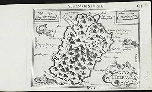
Sancta Helena
Verlag: Antwerp, 1598
Anbieter: Clive A. Burden Ltd., Chalfont St. Giles, BUCKS, Vereinigtes Königreich
Verkäuferbewertung 5 von 5 Sternen
Karte
EUR 177,01
EUR 25,38 Versand
Versand von Vereinigtes Königreich nach USAAnzahl: 1 verfügbar
In den WarenkorbNo binding. 90 x 120 mm., in good condition. This fine early map of Saint Helena in the Atlantic Ocean with two small insets at the top. It is finely engraved by Benjamin Wright and was first published in the 'Caert-Thresoor' of 1598. This example is from the 1609 with Dutch text to the verso. Van der Krogt, P. (Atlantes).
-
Rhodos: Rhodi Rodes 1598
Verlag: Langenes, Middelburg
Anbieter: Antiquariat Vlma, Herbrechtingen, Deutschland
Verkäuferbewertung 5 von 5 Sternen
Karte Erstausgabe
Kein Einband. Zustand: Gut. 1. Auflage. Karte von Rhodos! Map from Rhodos! very rare, first edition. Engraving by Petrus Kaerius. It is a copy of the very first edition of the "Caert-Thresoor, .", published in Middelburg in 1598 by Barent Langenes. Some spots in the margins. Verso: Dutch text. Old coloured. Very nice! complete 16,5x11cm. Kleinformat.
-

(Celestial Map) Le Globe Celeste
Verlag: France, 1609
Anbieter: Hornseys, Ripon, Vereinigtes Königreich
Verbandsmitglied: PBFA
Verkäuferbewertung 5 von 5 Sternen
EUR 206,51
EUR 28,64 Versand
Versand von Vereinigtes Königreich nach USAAnzahl: 1 verfügbar
In den WarenkorbNo Binding. Zustand: Good. 1st edition thus. Original copper engraving. Date: 1609. Sheet size: 16.8cm x 10.6cm. From 'Thresor de Chartes, contenant les Tableaux de tous les Pays du Monde'. Based on the celestial map from Ortelius' Epitome. Text in French to the verso. Early, but not original hand-colouring. A little dusty and with staining to the margins else in good, clean condition. Very scarce.
-

Saxonia Thuringia Misnia.
Erscheinungsdatum: 1599
Anbieter: Altea Antique Maps, London, Vereinigtes Königreich
Verbandsmitglied: ABA ILAB PBFA
Verkäuferbewertung 5 von 5 Sternen
Karte Erstausgabe
EUR 59,00
EUR 40,10 Versand
Versand von Vereinigtes Königreich nach USAAnzahl: 1 verfügbar
In den WarenkorbAmsterdam, Cornelis Claez, 1599, Dutch text edition. 85 x 125, with letterpress surtitle and pagination. Some paper toning. A scarce map of Saxony, Thuringia & Meissen, engraved by either Pieter van den Keere or Jodocus Hondius for the 1598 'Caert-Thresoor', with a text by an unknown author. Despite being published a year after the first edition, this is a second state: the right border has been re-engraved with latitude graduations. In 1600 this map was being published in the 'Tabularum Geographicarum' with a text by Petrus Bertius, and in 1616 a new plate was engraved by Jodocus Hondius II, slightly larger and with wider borders with scales of longitude and latitude.
-

Westphalia.
Erscheinungsdatum: 1599
Anbieter: Altea Antique Maps, London, Vereinigtes Königreich
Verbandsmitglied: ABA ILAB PBFA
Verkäuferbewertung 5 von 5 Sternen
Karte Erstausgabe
EUR 59,00
EUR 40,10 Versand
Versand von Vereinigtes Königreich nach USAAnzahl: 1 verfügbar
In den WarenkorbAmsterdam, Cornelis Claez, 1599, Dutch text edition. 85 x 125, with letterpress surtitle and pagination. Some damp staining. A scarce map of Westphalia, orientated with north to the left, engraved by either Pieter van den Keere or Jodocus Hondius for the 1598 'Caert-Thresoor', with a text by an unknown author. Despite being published a year after the first edition, this is a second state: the top border has been re-engraved with latitude graduations. In 1600 this map was being published in the 'Tabularum Geographicarum' with a text by Petrus Bertius, and in 1616 a new plate was engraved by Jodocus Hondius II, slightly larger and with wider borders with scales of longitude and latitude.
-

Hannonia,
Erscheinungsdatum: 1599
Anbieter: Altea Antique Maps, London, Vereinigtes Königreich
Verbandsmitglied: ABA ILAB PBFA
Verkäuferbewertung 5 von 5 Sternen
Karte
EUR 59,00
EUR 40,10 Versand
Versand von Vereinigtes Königreich nach USAAnzahl: 1 verfügbar
In den WarenkorbAmsterdam, Cornelis Claez, 1599, Dutch text edition. 85 x 125, with letterpress surtitle and pagination. Faint damp stains. A scarce map of Hainaut, engraved by either Pieter van den Keere or Jodocus Hondius for the 1598 'Caert-Thresoor', with a text by an unknown author. In 1600 this map was being published in the 'Tabularum Geographicarum' with a text by Petrus Bertius, and in 1616 a new plate was engraved by Jodocus Hondius II, slightly larger and with wider borders with scales of longitude and latitude.
-

Picardia.
Erscheinungsdatum: 1599
Anbieter: Altea Antique Maps, London, Vereinigtes Königreich
Verbandsmitglied: ABA ILAB PBFA
Verkäuferbewertung 5 von 5 Sternen
Karte Erstausgabe
EUR 59,00
EUR 40,10 Versand
Versand von Vereinigtes Königreich nach USAAnzahl: 1 verfügbar
In den WarenkorbAmsterdam, Cornelis Claez, 1599, Dutch text edition. 85 x 125, with letterpress surtitle and pagination. Faint damp stains. A scarce map of south Picardy, marking Amiens, engraved by either Pieter van den Keere or Jodocus Hondius for the 1598 'Caert-Thresoor', with a text by an unknown author. Despite being published a year after the first edition, this is a second state: the lateral borders have been re-engraved with latitude graduations. In 1600 this map was being published in the 'Tabularum Geographicarum' with a text by Petrus Bertius, and in 1616 a new plate was engraved by Jodocus Hondius II, slightly larger and with wider borders with scales of longitude and latitude.
-

Veromadui.
Erscheinungsdatum: 1599
Anbieter: Altea Antique Maps, London, Vereinigtes Königreich
Verbandsmitglied: ABA ILAB PBFA
Verkäuferbewertung 5 von 5 Sternen
Karte
EUR 59,00
EUR 40,10 Versand
Versand von Vereinigtes Königreich nach USAAnzahl: 1 verfügbar
In den WarenkorbAmsterdam, Cornelis Claez, 1599, Dutch text edition. 85 x 125, with letterpress surtitle and pagination. Faint damp stains. A scarce map of Vermandois, part of Picardy, engraved by either Pieter van den Keere or Jodocus Hondius for the 1598 'Caert-Thresoor', with a text by an unknown author. In 1600 this map was being published in the 'Tabularum Geographicarum' with a text by Petrus Bertius, and in 1616 a new plate was engraved by Jodocus Hondius II, slightly larger and with wider borders with scales of longitude and latitude.
-

Burgundiae Com.
Erscheinungsdatum: 1599
Anbieter: Altea Antique Maps, London, Vereinigtes Königreich
Verbandsmitglied: ABA ILAB PBFA
Verkäuferbewertung 5 von 5 Sternen
Karte Erstausgabe
EUR 59,00
EUR 40,10 Versand
Versand von Vereinigtes Königreich nach USAAnzahl: 1 verfügbar
In den WarenkorbAmsterdam, Cornelis Claez, 1599, Dutch text edition. 85 x 125, with letterpress surtitle and pagination. Faint damp stains. A scarce map of Franche-Comté, orientated with north to the left, engraved by either Pieter van den Keere or Jodocus Hondius for the 1598 'Caert-Thresoor', with a text by an unknown author. Despite being published a year after the first edition, this is a second state: the top border has been re-engraved with latitude graduations. In 1600 this map was being published in the 'Tabularum Geographicarum' with a text by Petrus Bertius, and in 1616 a new plate was engraved by Jodocus Hondius II, slightly larger and with wider borders with scales of longitude and latitude.
-

Lotharingia.
Erscheinungsdatum: 1599
Anbieter: Altea Antique Maps, London, Vereinigtes Königreich
Verbandsmitglied: ABA ILAB PBFA
Verkäuferbewertung 5 von 5 Sternen
Karte Erstausgabe
EUR 59,00
EUR 40,10 Versand
Versand von Vereinigtes Königreich nach USAAnzahl: 1 verfügbar
In den WarenkorbAmsterdam, Cornelis Claez, 1599, Dutch text edition. 85 x 125, with letterpress surtitle and pagination. Faint damp stains. A scarce map of Lorraine, orientated with north to the left, engraved by either Pieter van den Keere or Jodocus Hondius for the 1598 'Caert-Thresoor', with a text by an unknown author. Despite being published a year after the first edition, this is a second state: the bottom border has been re-engraved with latitude graduations. In 1600 this map was being published in the 'Tabularum Geographicarum' with a text by Petrus Bertius, and in 1616 a new plate was engraved by Jodocus Hondius II, slightly larger and with wider borders with scales of longitude and latitude.
-

Trans-Isula.D.
Erscheinungsdatum: 1599
Anbieter: Altea Antique Maps, London, Vereinigtes Königreich
Verbandsmitglied: ABA ILAB PBFA
Verkäuferbewertung 5 von 5 Sternen
Karte Erstausgabe
EUR 64,90
EUR 40,10 Versand
Versand von Vereinigtes Königreich nach USAAnzahl: 1 verfügbar
In den WarenkorbAmsterdam, Cornelis Claez, 1599, Dutch text edition. 85 x 125, with letterpress surtitle and pagination. Some age toning. A scarce map of Overijssel, orientated with north to the right, engraved by either Pieter van den Keere or Jodocus Hondius for the 1598 'Caert-Thresoor', with a text by an unknown author. Despite being published a year after the first edition, this is a second state: the top and bottom borders have been re-engraved with latitude graduations. In 1600 this map was being published in the 'Tabularum Geographicarum' with a text by Petrus Bertius, and in 1616 a new plate was engraved by Jodocus Hondius II, slightly larger and with wider borders with scales of longitude and latitude.
-

Namur.
Erscheinungsdatum: 1599
Anbieter: Altea Antique Maps, London, Vereinigtes Königreich
Verbandsmitglied: ABA ILAB PBFA
Verkäuferbewertung 5 von 5 Sternen
Karte
EUR 64,90
EUR 40,10 Versand
Versand von Vereinigtes Königreich nach USAAnzahl: 1 verfügbar
In den WarenkorbAmsterdam, Cornelis Claez, 1599, Dutch text edition. 85 x 125, with letterpress surtitle and pagination. Faint damp stains. A scarce map of Namur, engraved by either Pieter van den Keere or Jodocus Hondius for the 1598 'Caert-Thresoor', with a text by an unknown author. In 1600 this map was being published in the 'Tabularum Geographicarum' with a text by Petrus Bertius, and in 1616 a new plate was engraved by Jodocus Hondius II, slightly larger and with wider borders with scales of longitude and latitude.
-

Anjou.
Erscheinungsdatum: 1599
Anbieter: Altea Antique Maps, London, Vereinigtes Königreich
Verbandsmitglied: ABA ILAB PBFA
Verkäuferbewertung 5 von 5 Sternen
Karte Erstausgabe
EUR 64,90
EUR 40,10 Versand
Versand von Vereinigtes Königreich nach USAAnzahl: 1 verfügbar
In den WarenkorbAmsterdam, Cornelis Claez, 1599, Dutch text edition. 85 x 125, with letterpress surtitle and pagination. Faint damp stains. A scarce map of Anjou, engraved by either Pieter van den Keere or Jodocus Hondius for the 1598 'Caert-Thresoor', with a text by an unknown author. Despite being published a year after the first edition, this is a second state: the left border has been re-engraved with latitude graduations. In 1600 this map was being published in the 'Tabularum Geographicarum' with a text by Petrus Bertius, and in 1616 a new plate was engraved by Jodocus Hondius II, slightly larger and with wider borders with scales of longitude and latitude.
-

Leodiensis Dioecesis.
Erscheinungsdatum: 1599
Anbieter: Altea Antique Maps, London, Vereinigtes Königreich
Verbandsmitglied: ABA ILAB PBFA
Verkäuferbewertung 5 von 5 Sternen
Karte Erstausgabe
EUR 64,90
EUR 40,10 Versand
Versand von Vereinigtes Königreich nach USAAnzahl: 1 verfügbar
In den WarenkorbAmsterdam, Cornelis Claez, 1599, Dutch text edition. 85 x 125, with letterpress surtitle and pagination. Faint damp stains. A scarce map of the Diocese of Ličge orientated with north to the left, marking Maastricht, engraved by either Pieter van den Keere or Jodocus Hondius for the 1598 'Caert-Thresoor', with a text by an unknown author. Despite being published a year after the first edition, this is a second state: the top border has been re-engraved with graduations for latitude. In 1600 this map was being published in the 'Tabularum Geographicarum' with a text by Petrus Bertius, and in 1616 a new plate was engraved by Jodocus Hondius II, slightly larger and with wider borders with scales of longitude and latitude.
-

Burgundiae Ducatus.
Erscheinungsdatum: 1599
Anbieter: Altea Antique Maps, London, Vereinigtes Königreich
Verbandsmitglied: ABA ILAB PBFA
Verkäuferbewertung 5 von 5 Sternen
Karte
EUR 64,90
EUR 40,10 Versand
Versand von Vereinigtes Königreich nach USAAnzahl: 1 verfügbar
In den WarenkorbAmsterdam, Cornelis Claez, 1599, Dutch text edition. 85 x 125, with letterpress surtitle and pagination. Faint damp stains. A scarce map of the Duchy of Burgundy, engraved by either Pieter van den Keere or Jodocus Hondius for the 1598 'Caert-Thresoor', with a text by an unknown author. In 1600 this map was being published in the 'Tabularum Geographicarum' with a text by Petrus Bertius, and in 1616 a new plate was engraved by Jodocus Hondius II, slightly larger and with wider borders with scales of longitude and latitude.
-

Limantia.
Erscheinungsdatum: 1599
Anbieter: Altea Antique Maps, London, Vereinigtes Königreich
Verbandsmitglied: ABA ILAB PBFA
Verkäuferbewertung 5 von 5 Sternen
Karte
EUR 64,90
EUR 40,10 Versand
Versand von Vereinigtes Königreich nach USAAnzahl: 1 verfügbar
In den WarenkorbAmsterdam, Cornelis Claez, 1599, Dutch text edition. 85 x 125, with letterpress surtitle and pagination. Faint damp stains. A scarce map of Limousin, engraved by either Pieter van den Keere or Jodocus Hondius for the 1598 'Caert-Thresoor', with a text by an unknown author. In 1600 this map was being published in the 'Tabularum Geographicarum' with a text by Petrus Bertius, and in 1616 a new plate was engraved by Jodocus Hondius II, slightly larger and with wider borders with scales of longitude and latitude.
-

Thiet Marsia
Erscheinungsdatum: 1599
Anbieter: Altea Antique Maps, London, Vereinigtes Königreich
Verbandsmitglied: ABA ILAB PBFA
Verkäuferbewertung 5 von 5 Sternen
Karte
EUR 64,90
EUR 40,10 Versand
Versand von Vereinigtes Königreich nach USAAnzahl: 1 verfügbar
In den WarenkorbAmsterdam, Cornelis Claez, 1599, Dutch text edition. 85 x 125, with letterpress surtitle and pagination. Some damp staining. A scarce map of Dithmarschen, orientated with north to the left, engraved by either Pieter van den Keere or Jodocus Hondius for the 1598 'Caert-Thresoor', with a text by an unknown author. Of interest is Büsum, shown as an island despite being connected to the mainland by the building of a dam in 1585. In 1600 this map was being published in the 'Tabularum Geographicarum' with a text by Petrus Bertius, and in 1616 a new plate was engraved by Jodocus Hondius II, slightly larger and with wider borders with scales of longitude and latitude.
-

Venuximus Comitatus.
Erscheinungsdatum: 1599
Anbieter: Altea Antique Maps, London, Vereinigtes Königreich
Verbandsmitglied: ABA ILAB PBFA
Verkäuferbewertung 5 von 5 Sternen
Karte Erstausgabe
EUR 64,90
EUR 40,10 Versand
Versand von Vereinigtes Königreich nach USAAnzahl: 1 verfügbar
In den WarenkorbAmsterdam, Cornelis Claez, 1599, Dutch text edition. 85 x 125, with letterpress surtitle and pagination. Faint damp stains. A scarce map of Comtat Venaissin, an enclave of the Papal States at Avignon. It was engraved by either Pieter van den Keere or Jodocus Hondius for the 1598 'Caert-Thresoor', with a text by an unknown author. Despite being published a year after the first edition, this is a second state: the top border has been re-engraved with latitude graduations. In 1600 this map was being published in the 'Tabularum Geographicarum' with a text by Petrus Bertius, and in 1616 a new plate was engraved by Jodocus Hondius II, slightly larger and with wider borders with scales of longitude and latitude.
-

Artesia.
Erscheinungsdatum: 1599
Anbieter: Altea Antique Maps, London, Vereinigtes Königreich
Verbandsmitglied: ABA ILAB PBFA
Verkäuferbewertung 5 von 5 Sternen
Karte Erstausgabe
EUR 64,90
EUR 40,10 Versand
Versand von Vereinigtes Königreich nach USAAnzahl: 1 verfügbar
In den WarenkorbAmsterdam, Cornelis Claez, 1599, Dutch text edition. 85 x 125, with letterpress surtitle and pagination. Faint damp stains. A scarce map of Artois, marking Calais, Boulogne & Douay, engraved by either Pieter van den Keere or Jodocus Hondius for the 1598 'Caert-Thresoor', with a text by an unknown author. Despite being published a year after the first edition, this is a second state: the left border has been re-engraved with latitude graduations. In 1600 this map was being published in the 'Tabularum Geographicarum' with a text by Petrus Bertius, and in 1616 a new plate was engraved by Jodocus Hondius II, slightly larger and with wider borders with scales of longitude and latitude.
-

Biturigum.
Erscheinungsdatum: 1599
Anbieter: Altea Antique Maps, London, Vereinigtes Königreich
Verbandsmitglied: ABA ILAB PBFA
Verkäuferbewertung 5 von 5 Sternen
Karte Erstausgabe
EUR 64,90
EUR 40,10 Versand
Versand von Vereinigtes Königreich nach USAAnzahl: 1 verfügbar
In den WarenkorbAmsterdam, Cornelis Claez, 1599, Dutch text edition. 85 x 125, with letterpress surtitle and pagination. Faint damp stains. A scarce map of Berry, engraved by either Pieter van den Keere or Jodocus Hondius for the 1598 'Caert-Thresoor', with a text by an unknown author. Despite being published a year after the first edition, this is a second state: the right border has been re-engraved with latitude graduations. In 1600 this map was being published in the 'Tabularum Geographicarum' with a text by Petrus Bertius, and in 1616 a new plate was engraved by Jodocus Hondius II, slightly larger and with wider borders with scales of longitude and latitude.
-
![Bild des Verkäufers für [t'Clooster van S.Laurens in Escuriael.] zum Verkauf von Altea Antique Maps](https://pictures.abebooks.com/inventory/md/md30789129932.jpg)
[t'Clooster van S.Laurens in Escuriael.]
Erscheinungsdatum: 1599
Anbieter: Altea Antique Maps, London, Vereinigtes Königreich
Verbandsmitglied: ABA ILAB PBFA
Verkäuferbewertung 5 von 5 Sternen
Karte
EUR 70,80
EUR 40,10 Versand
Versand von Vereinigtes Königreich nach USAAnzahl: 1 verfügbar
In den WarenkorbAmsterdam, Cornelis Claez, 1599, Dutch text edition. 85 x 125, with letterpress surtitle and pagination. Faint damp stains. A scarce view of the Spanish Royal palace, engraved by either Pieter van den Keere or Jodocus Hondius after a plate in the 'Theatrum Orbis Terrarum' by Ortelius. It was published in an early issue of the pocket atlas, the 'Caert-Thresoor', with a text by an unknown author. The title comes from the letterpress above the plate. By 1600 this view was being published in the 'Tabularum Geographicarum' with a text by Petrus Bertius,
-

Caletensium et Bonenesium des.
Erscheinungsdatum: 1599
Anbieter: Altea Antique Maps, London, Vereinigtes Königreich
Verbandsmitglied: ABA ILAB PBFA
Verkäuferbewertung 5 von 5 Sternen
Karte
EUR 70,80
EUR 40,10 Versand
Versand von Vereinigtes Königreich nach USAAnzahl: 1 verfügbar
In den WarenkorbAmsterdam, Cornelis Claez, 1599, Dutch text edition. 85 x 125, with letterpress surtitle and pagination. Faint damp stains. A scarce map of northern Picardy orientated with north to the left, marking Calais and Boulogne, engraved by either Pieter van den Keere or Jodocus Hondius for the 1598 'Caert-Thresoor', with a text by an unknown author. In 1600 this map was being published in the 'Tabularum Geographicarum' with a text by Petrus Bertius, and in 1616 a new plate was engraved by Jodocus Hondius II, slightly larger and with wider borders with scales of longitude and latitude.
-

Poictou.
Erscheinungsdatum: 1599
Anbieter: Altea Antique Maps, London, Vereinigtes Königreich
Verbandsmitglied: ABA ILAB PBFA
Verkäuferbewertung 5 von 5 Sternen
Karte Erstausgabe
EUR 70,80
EUR 40,10 Versand
Versand von Vereinigtes Königreich nach USAAnzahl: 1 verfügbar
In den WarenkorbAmsterdam, Cornelis Claez, 1599, Dutch text edition. 85 x 125, with letterpress surtitle and pagination. Faint damp stains. A scarce map of Poitou, engraved by either Pieter van den Keere or Jodocus Hondius for the 1598 'Caert-Thresoor', with a text by an unknown author. Despite being published a year after the first edition, this is a second state: the lateral borders have been re-engraved with latitude graduations. In 1600 this map was being published in the 'Tabularum Geographicarum' with a text by Petrus Bertius, and in 1616 a new plate was engraved by Jodocus Hondius II, slightly larger and with wider borders with scales of longitude and latitude.

