Gesamtpreis (1 Artikel Artikel):
Versandziel:

jode gerard (39 Ergebnisse)
Direkt zu den wichtigsten Suchergebnissen
Suchfilter
Produktart
- Alle Product Types
- Bücher (16)
- Magazine & Zeitschriften (Keine weiteren Ergebnisse entsprechen dieser Verfeinerung)
- Comics (Keine weiteren Ergebnisse entsprechen dieser Verfeinerung)
- Noten (Keine weiteren Ergebnisse entsprechen dieser Verfeinerung)
- Kunst, Grafik & Poster (15)
- Fotografien (Keine weiteren Ergebnisse entsprechen dieser Verfeinerung)
- Karten (8)
- Manuskripte & Papierantiquitäten (Keine weiteren Ergebnisse entsprechen dieser Verfeinerung)
Zustand Mehr dazu
- Neu (4)
- Wie Neu, Sehr Gut oder Gut Bis Sehr Gut (1)
- Gut oder Befriedigend (10)
- Ausreichend oder Schlecht (Keine weiteren Ergebnisse entsprechen dieser Verfeinerung)
- Wie beschrieben (24)
Einband
Weitere Eigenschaften
- Erstausgabe (3)
- Signiert (Keine weiteren Ergebnisse entsprechen dieser Verfeinerung)
- Schutzumschlag (1)
- Angebotsfoto (36)
Sprache (3)
Gratisversand
Land des Verkäufers
Verkäuferbewertung
-

L'oeuvre cartographique de Gérard et de Corneille de Jode.
Anbieter: Antiquariaat A. Kok & Zn. B.V., Amsterdam, Niederlande
Verkäuferbewertung 5 von 5 Sternen

Gand, Librairie Scientifique E. van Goethem & Cie., 1914. XXXV,127 pp. 6 b./q. plts. Orig. softcover (pinted wrappers). 8vo. - Spine dam,/ loose. (Université de Gand. Recueil de trvaux publie s par la faculte de philosophie et lettres, 44 fascicule).
-
EUR 23,61
EUR 48,99 Versand
Versand von Deutschland nach USAAnzahl: Mehr als 20 verfügbar
In den WarenkorbZustand: New.
-
EUR 26,25
EUR 48,99 Versand
Versand von Deutschland nach USAAnzahl: Mehr als 20 verfügbar
In den WarenkorbZustand: New.
-

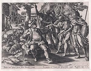
"Tondet oves Nabal, quem servi Davidis." - David's men asking Nabal for food Bible Bibel
Sprache: Latein
Verlag: Amsterdam, Claes Janszoon Visscher, 1600
Anbieter: Antiquariat Steffen Völkel GmbH, Seubersdorf, Deutschland
Verkäuferbewertung 5 von 5 Sternen
Kunst / Grafik / Poster
Original Kupferstich von ca. 1600. -- Platten-Maße: ca. 21 x 26 cm; mit schmalen Rändchen. -- gut erhalten. || Original copper engraving from c. 1600. --- With narrow margins. -- in good condition. // Wir, das Antiquariat Steffen Völkel, kaufen und verkaufen alte Bücher, Handschriften, Zeichnungen, Autographen, Grafiken und Fotografien. Wir sind stets am Ankauf von kompletten Bibliotheken, Sammlungen und Nachlässen interessiert. la Gewicht in Gramm: 15.
-

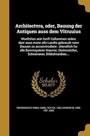
Architectvra, oder, Bauung der Antiquen auss dem Vitruuius : Woellches sein funff Collummen orden, daer auss mann alle Landts gebreuch vonn Bauuen zu accommodiere? dienstlich fur alle Bawmaystren Maurrer, Stainmetzlen, Schreineren, Bildtshneidren, .
Sprache: Deutsch
Verlag: Creative Media Partners, LLC Aug 2016, 2016
ISBN 10: 1363041010 ISBN 13: 9781363041015
Anbieter: AHA-BUCH GmbH, Einbeck, Deutschland
Verkäuferbewertung 5 von 5 Sternen
Taschenbuch. Zustand: Neu. Neuware - This work has been selected by scholars as being culturally important, and is part of the knowledge base of civilization as we know it. This work was reproduced from the original artifact, and remains as true to the original work as possible. Therefore, you will see the original copyright references, library stamps (as most of these works have been housed in our most important libraries around the world), and other notations in the work.
-

Mikrokósmos = Paruus mundus
Sprache: Latein
Verlag: Creative Media Partners, LLC Aug 2016, 2016
ISBN 10: 1372973923 ISBN 13: 9781372973925
Anbieter: AHA-BUCH GmbH, Einbeck, Deutschland
Verkäuferbewertung 5 von 5 Sternen
Taschenbuch. Zustand: Neu. Neuware - This work has been selected by scholars as being culturally important, and is part of the knowledge base of civilization as we know it. This work was reproduced from the original artifact, and remains as true to the original work as possible. Therefore, you will see the original copyright references, library stamps (as most of these works have been housed in our most important libraries around the world), and other notations in the work.
-
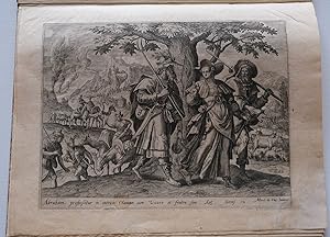
THE STORY OF ABRAHAM from Thesaurus Sacrarum Historiarum Veteris Testamenti etc. HISTORIA ABRAHAMI.
Verlag: Antwerp. de Jode circa 1585, 1585
Anbieter: Charles Russell, ABA, ILAB, est 1978, Cirencester, Vereinigtes Königreich
Verbandsmitglied: ABA ILAB PBFA
Verkäuferbewertung 5 von 5 Sternen
EUR 715,48
EUR 4,75 Versand
Versand von Vereinigtes Königreich nach USAAnzahl: 1 verfügbar
In den WarenkorbQuarto book size 13x10 inches bound in modern marbled paper boards, leather lettering label to the upper board, spine worn. The complete set of six prints of the story of Abraham from this work. Plates after Maarten de Vos. Some professional restoration.
-

Franconia, nobilissim Germaniae ducatus, de Jode, 1593
Verlag: Jode Gerard de, 1509-1591, 1591
Anbieter: Hammelburger Antiquariat, Hammelburg, Deutschland
Verkäuferbewertung 5 von 5 Sternen
Hardcover. Zustand: very good. Franconia, nobilissim Germaniae ducatus, de Jode, 1593 Franconia Nobilissim. Germaniae Ducatus - de Jode ,1593. Size: 35 x 46cm., little brownish Verso text: Latin From: Speculum Orbis Terrae. Antwerpen, G. De Jode, 1593. (Van der Krogt 3, 2:02) "In 1578 Gerard de Jode published his Speculum Orbis Terrarum, an atlas aimed at competing with the Theatrum of Ortelius. However, the latter had first been issued in 1570 and had already built a commanding market presence, and so despite de Jode's longer standing reputation the atlas did not sell very well. Only a dozen or so examples have survived.
-
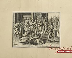
"Hic Regis proceres abscondunt carcere Varem. Aethiope ab laxis funibus eximitur. Hieremias 38. Cap." Aus einer Folge von Illustrationen zur Bibel.
Verlag: Niederlande um 1600., 1600
Anbieter: Antiquariat MEINDL & SULZMANN OG, Wien - Vienna, Österreich
Verkäuferbewertung 5 von 5 Sternen
Blattgröße ca. 36 x 44 cm, Bildausschnitt ca. 19 x 26,5 cm (Kräftiger Abzug. Bis an den Rand der Darstellung beschnitten und auf Papier des 18. Jhdts. aufgezogen. Mit schwarzer Tuschlinie umfasst. Papier etw. gebräunt). Der Prophet Jeremia lebte etwa von 660 bis 580 v. Chr. und übte seinen Dienst unter den letzten sieben Königen von Juda aus. Er stammte aus einem Priestergeschlecht in Anatot, wurde schon in jungen Jahren als Prophet berufen und blieb um den Herrn willen ledig. Als Bote des Herrn mußte er dem immer verderbter handelnden Volk eine ernste Gerichtsbotschaft verkünden, an der der empfindsame Jeremia selbst sehr litt; er wird nicht umsonst "der weinende Prophet" genannt. Für seine Botschaft, daß Jerusalem fallen und Juda in Gefangenschaft geraten wird, schlug ihm von den Führern und dem Volk viel Haß und Feindseligkeit entgegen; er wurde als Landesverräter ins Gefängnis geworfen und kam beinahe in einer Zisterne um.
-
"Tondet oves Nabal, quem servi Davidis." - David's men asking Nabal for food Bible Bibel
Sprache: Latein
Verlag: Antwerpen, Gerard de Jode ca. 1580., 1580
Anbieter: Antiquariat Steffen Völkel GmbH, Seubersdorf, Deutschland
Verkäuferbewertung 5 von 5 Sternen
Kunst / Grafik / Poster
Original Kupferstich von ca. 1580. -- Knapp beschnitten und alt aufgezogen. -- Blatt-Maße: ca. 26 x 20,5 cm. -- gut erhalten. || Original copper engraving from c. 1580. -- Narrowly cut and laid down. -- in good condition. || // Wir, das Antiquariat Steffen Völkel, kaufen und verkaufen alte Bücher, Handschriften, Zeichnungen, Autographen, Grafiken und Fotografien. Wir sind stets am Ankauf von kompletten Bibliotheken, Sammlungen und Nachlässen interessiert. la Gewicht in Gramm: 20.
-

"Dum lavat et recreat grelido sua flumine." - Bathsheba receiving David's letter Bible Bibel
Sprache: Latein
Verlag: Amsterdam, Claes Janszoon Visscher, 1600
Anbieter: Antiquariat Steffen Völkel GmbH, Seubersdorf, Deutschland
Verkäuferbewertung 5 von 5 Sternen
Kunst / Grafik / Poster
Original Kupferstich von ca. 1600. -- Platten-Maße: ca. 21 x 28 cm; mit schmalen Rändchen. -- gut erhalten. || Original copper engraving from c. 1600. --- With narrow margins. -- in good condition. // Wir, das Antiquariat Steffen Völkel, kaufen und verkaufen alte Bücher, Handschriften, Zeichnungen, Autographen, Grafiken und Fotografien. Wir sind stets am Ankauf von kompletten Bibliotheken, Sammlungen und Nachlässen interessiert. la Gewicht in Gramm: 15.
-
Speculum Orbis Terrarum. / Speculum geographicum totius Germaniae Imperium repraesentans.
Anbieter: Antiquariaat A. Kok & Zn. B.V., Amsterdam, Niederlande
Verkäuferbewertung 5 von 5 Sternen
Antwerp, 1578 [reprint Amst., 1965]. 2 parts in 1. XIV, [292] pp. 65 b./w. maps (64 double-page, 1 single-page). Re-bound in modern hardcover (gilt lettered dark blue linen over boards), no d./j. Folio. (Theatrum Orbis Terrarum, 2nd series, vol. II).Facsimile of the 1578 edition including the second part "Speculum geographicum totius Germaniae Imperium repraesentans" (most likely published as a separate work in 1573). - With a bibliographical note (6 pages) by R.A. Skelton and a comparative table of maps (3 pages).
-
Speculum Orbis Terrarum. / Speculum geographicum totius Germaniae Imperium repraesentans.
Anbieter: Antiquariaat A. Kok & Zn. B.V., Amsterdam, Niederlande
Verkäuferbewertung 5 von 5 Sternen
Antwerp, 1578 [reprint Amst., 1965]. 2 parts in 1. XIV, [292] pp. 65 b./w. maps (64 double-page, 1 single-page). Re-bound in modern hardcover (black h.buckram, gilt lettered spine, gray linen over boards), d./j. Folio. - Dust jacket with light shelfwear. (Theatrum Orbis Terrarum, 2nd series, vol. II).Re-bound copy with the original dust jacket. - Facsimile of the 1578 edition including the second part "Speculum geographicum totius Germaniae Imperium repraesentans" (most likely published as a separate work in 1573). - With a bibliographical note (6 pages) by R.A. Skelton and a comparative table of maps (3 pages).
-

"Bonum Semen Seminatum Unde Ergo Zizania." - Parable of the sower / Bibel Bible
Sprache: Latein
Verlag: Amsterdam, Claes Janszoon Visscher, 1600
Anbieter: Antiquariat Steffen Völkel GmbH, Seubersdorf, Deutschland
Verkäuferbewertung 5 von 5 Sternen
Kunst / Grafik / Poster
Original Kupferstich von ca. 1600. -- Platten-Maße: ca. 21 x 25 cm; mit schmalen Rändchen. -- gut erhalten. || Original copper engraving from c. 1600. --- With narrow margins. -- in good condition. // Wir, das Antiquariat Steffen Völkel, kaufen und verkaufen alte Bücher, Handschriften, Zeichnungen, Autographen, Grafiken und Fotografien. Wir sind stets am Ankauf von kompletten Bibliotheken, Sammlungen und Nachlässen interessiert. la Gewicht in Gramm: 15.
-
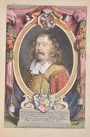
Maximilianus, Comes Curtius, Baro de Senstenau, et Drosendorff, Dominus in Liecktenberg, ac Haltenberg, Serenissimi Bavariae Electoris Confilii?
Verlag: Artist: Jodede Gerard ( - 1591 ) Antwerp dated : 1658, 1509
Anbieter: Antique Sommer& Sapunaru KG, München, Deutschland
Verkäuferbewertung 3 von 5 Sternen

Kunst / Grafik / Poster
Technic: Copper print, colorit: colored, condition: Small missing part at upper margin replaced, size (in cm): 31 x 20,5, Decorative title page of Maximilian Graf von Valley (1595 - 1662). He comes from the royal house of Arco and was grown up in Munich. The director of the Privy Council was envoy to the Peace of Westphalia in 1648, Hofmarksherr vonhaltenberg and Lichtenberg, Count von Valley in Ahamstein, Holzolling and Feldolling, caretaker in Bärnstein, Kling and Friedberg. Copper engraving by P. de Jode after A. van Hulle. As a descendant of the Arco (aristocratic family), Arco-Valley attended the Wilhelmsgymnasium in Munich until graduation in 1823. He studied at the University of Strasbourg and the University of Landshut, which was moved to Munich in 1826. In the same year he became active in the Corps Isaria Munich. He was the owner of the dominions of St. Martin and Aurolzmünster in Austria and the Bavarian estates Valley, Adldorf, Malgersdorf, Oberköllnbach and Baumgarten. Maximilian von und zu Arco-Valley was also a co-founder of the Süddeutsche Bodenkreditbank. In 1828 he became a member of the Chamber of the Bavarian Imperial Councils for life. From 1868 to 1870 he was also a member of the customs parliament as a member of the Schwaben 3 constituency (Dillingen, Günzburg, Zusmarshausen). There he represented the political direction of the Bavarian Patriot Party.
-
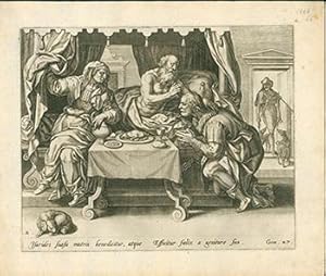
Engraving from The Story of Jacob and Esau: Blind Isaac blessing Jacob disguised as Esau First edition.
Verlag: Netherlandis: Gerard de Jode circa 1587, 1587
Anbieter: Wittenborn Art Books, San Francisco, CA, USA
Verkäuferbewertung 5 von 5 Sternen
Kunst / Grafik / Poster
Zustand: Good. Engraving on contemporary laid paper. 27 x 32.5 cm. sheet size. Wide margins. At bottom center: Isarides suasu matris benedicitur, atque / Efficitur faelix a genitore suo. / Gene .27. After Maarten de Vos. Pl. 2 from the series «The story of Jacob and Esau», published by Gerard de Jode: Blind Isaac blessing Jacob disguised as Esau. Ref. Hollstein XLIV: 69. Met Museum, 51.501.1715(2).
-
Illustration from "Speculum orbis Terrae" (1593) "De Institutione Et Ordine Imperii Germanici Tabula II"
Verlag: Arnold Coninx, Antwerpen, 1593
Anbieter: Rare Books Honolulu, Honolulu, HI, USA
Verbandsmitglied: IOBA
Verkäuferbewertung 5 von 5 Sternen
Kunst / Grafik / Poster
n/a. Zustand: Very Good. from the 2nd Edition. Antwerpen, Arnold Coninx, 1593 --- ---- This truly significant map is from one of the rarest atlases ever published, Gerard and Cornelis de Jode's Speculum orbis Terrae. The work was published in Antwerp in 1593 by Arnold Coninx for the widow and heirs. This is considered the second edition, revised and expanded. The first edition was published in 1578. Van Ortroy knew of only 14 copies of the second edition being published. (Skelton, Introduction to the facsimile editions) --- --- from the 2nd Edition, Very Good. --- --- --- --- De Jode drew upon his large stock of maps from Italian, German, and Flemish cartographers to create his atlas. He engraved some of the maps and his brothers, Joannes and Lucas van Deutecum, also contributed to the process. The second edition included additional maps from Gerard's son Cornelis. The maps have descriptive text to verso in Latin. The text for the first edition was written by the German scholar, Daniel Cellarius. The atlas contained some of the most groundbreaking maps ever published. The maps of the world, Americas, Australia, and China are of particular note and remain some of the most important maps ever published. While it may not have had commercial success at the time, it is considered a masterpiece of 16th century cartography. Very few examples of the maps have survived from either edition. Gerard de Jode (1521- 1591) was a Flemish cartographer, printer, and engraver. He produced and sold many maps in Antwerp, but his legacy lies in his outstanding atlas, Speculum Orbis Terrarum. De Jode was a contemporary and competitor of Abraham Ortelius. Ortelius was believed to have been responsible for delaying de Jode's work so his atlas Theatrum Orbis Terrarum would precede de Jode's. Because Ortelius's atlas had 8 years on the market it was well established and thus de Jode's atlas did not sell very well. To compete with Ortelius, de Jode worked on the second revised and expanded edition. De Jode's wife and son, Cornelis (1568-1600) took over the publishing upon Gerard's death in 1591. Cornelis prepared ten new maps of the World, North America, China, Australia and Alaska and re-issued the atlas. "Many of de Jode's maps are judged to be superior to those of Ortelius, both in detail and style." (Burden) Antwerp publisher Joan Baptista Vrients purchased the plates after Cornelis's death. He also acquired Ortelius's plates for Theatrum Orbis Terrarum to which he gave priority. It is likely he bought de Jode's plates to prevent any further editions of Speculum of course only increasing the intrigue and worth of the maps today. "Although the atlas may not have appealed to the public, it was admired by other cartographers. As evidence, Petrus Montanus mentions it in the same breath with Mercator's Atlas and Ortelius' Theatrum in his preface to Pieter Kaerius' Germaniae inferior (Wardington Catalogue), Michael von Aitzing refers to it in his work, DeLeone Belgico (1583). Von Aitzing intended his work to act also as a supplement to both the Theatrum of Ortelius and the Speculum of De Jode." (Burden) Provenance : Ownership inscription at the bottom of the title page ex Bibliotheca Prim d Federici 1600. References: Van der Krogt 32:02B (titles 32:2A and 32:2B) ; Koeman II, Jod 2 ; Shirley, The mapping of the world, 165,184 ; Burden, The mapping of America, 81, 82 ; Symour, L. Schwartz, Ehrenberg, The mapping of America, pp. 78-79 ; Norwich, Maps of Africa 19 ; Navari, Maps of Cyprus, 29 ; Tooley, Dictionnary of mapmakers II, p. 441 ; Tooley, Mapping of Australia,; Tooley, Arabia in early maps, 38 (1st ed.) ; Koeman, Schilder, van Egmond, van der Krogt, HOC,vol. 3 part 2, Commercial Cartography and Map Production in the Low Countries, 1500 ca. 1672, pp. 1321-1323 ; Ortroy, Fern van, L'oeuvre cartographique de Gerard et de Corneille de Jode, Gand 1914, 82-121.
-

Barbaria pars Apricć, Comprćhendens precipua Loca Versus littora Maris Mediterranei.
Verlag: Antwerp, 1593, Latin text edition. 360 x 460mm (14Ľ x 18 inches)., 1593
Anbieter: Tooley, Adams & Co., Wallingford, OXON, Vereinigtes Königreich
Verkäuferbewertung 4 von 5 Sternen

EUR 667,78
EUR 43,01 Versand
Versand von Vereinigtes Königreich nach USAAnzahl: 1 verfügbar
In den WarenkorbUncoloured; light spotting noticeable in the margins, light age-toning to centrefold, otherwise a fine example. From the 'Speculum Orbis Terrarum'.Two maps on one sheet of the north Africa coast from The Holy Land to Western Sahara. Shows, Morocco,Tunisia, Libya and Egypt. Decorated with ships and animals, including a lion and an elephant.
-

Turcia Turcicive Imperii seu Solij mannorum regni pleraque pars, nunc recens summa fide ac in dustria elucumbrata.
Verlag: Antwerp, 1593. 383 x 510mm (15 x 20 inches)., 1593
Anbieter: Tooley, Adams & Co., Wallingford, OXON, Vereinigtes Königreich
Verkäuferbewertung 4 von 5 Sternen
EUR 4.173,62
EUR 43,01 Versand
Versand von Vereinigtes Königreich nach USAAnzahl: 1 verfügbar
In den WarenkorbFine dark impression; very light age-toning, short split to lower part of centrefold in the margin, otherwise a fine example. From the 'Speculum Orbis Terrarum'. A map of the Turkish Empire engraved by Joannes Doetecum. Superbly engraved with sailing ships in the eastern Mediterranean Sea.
-

Barbaria pars Africae, Comprae: hendens praecipua Loca versus littoria Maris Mediterranei.
Verlag: Antwerp, 1593. 355 x 455mm (14 x 18 inches)., 1593
Anbieter: Tooley, Adams & Co., Wallingford, OXON, Vereinigtes Königreich
Verkäuferbewertung 5 von 5 Sternen
EUR 894,35
EUR 43,01 Versand
Versand von Vereinigtes Königreich nach USAAnzahl: 1 verfügbar
In den WarenkorbFine dark impression; very light age-toning to the upper part of centrefold, otherwise a fine example. From the 'Speculum Orbis Terrarum'.Two maps on one sheet of the north Africa coast from The Holy Land to Western Sahara. Shows, Morocco,Tunisia, Libya and Egypt. Decorated with ships and animals, including a lion and an elephant.
-

Descriptio et situs Terrć Sanctć alio nimine Palestina.
Verlag: Antwerp, 1593. 335 x 510mm (13Ľ x 20 inches)., 1593
Anbieter: Tooley, Adams & Co., Wallingford, OXON, Vereinigtes Königreich
Verkäuferbewertung 4 von 5 Sternen
Erstausgabe
EUR 5.723,82
EUR 43,01 Versand
Versand von Vereinigtes Königreich nach USAAnzahl: 1 verfügbar
In den WarenkorbUncoloured; very light age-toning, otherwise a fine example. A map of the Holy Land also called Palestine, shows the coastline from Tyrus to Gaza. Oriented to the east. The map has many illustrations depicting scenes from the Old and New Testament. This map does not appear in the first edition. LAOR: 376.
-

Primae Partis Asiae.
Verlag: Antwerp, 1593. 300 x 510mm (11ľ x 20 inches)., 1593
Anbieter: Tooley, Adams & Co., Wallingford, OXON, Vereinigtes Königreich
Verkäuferbewertung 4 von 5 Sternen
EUR 3.338,89
EUR 43,01 Versand
Versand von Vereinigtes Königreich nach USAAnzahl: 1 verfügbar
In den WarenkorbUncoloured; very light marginal soiling, otherwise a fine example. From the 'Speculum Orbis Terrarum'. A fine map of the Middle East from Turkey across to Persia and then down to Egypt.
-

Portugalliae quć olim Lusitania vernan do Alvaro Secco auctore recens descriptio.
Verlag: Antwerp, 1578-[93]. 315 x 525mm (12˝ x 20ľ inches)., 1578
Anbieter: Tooley, Adams & Co., Wallingford, OXON, Vereinigtes Königreich
Verkäuferbewertung 4 von 5 Sternen
EUR 930,12
EUR 43,01 Versand
Versand von Vereinigtes Königreich nach USAAnzahl: 1 verfügbar
In den WarenkorbFine dark impression, two small worm holes at the top-centre between the line printed border, with no loss of print. Very minor staining to the lower margin and a small repaired tear to top margin away from printed surface, otherwise fine. A rare chart of Portugal from the surveys of Fernado Alvares Seco, and published in the 'Speculum Orbis Terrarum'. Little is known of Seco himself, although his family were well known and influential, and quite possibly originally from Milan. Highly decorated with sailing ships of all kinds, sea monsters and a simple compass rose. A fine example of the skill of the engravers Joannes and Lucas Doetecum.
-

Portugalliae Portugalliae Quae Olim Lusitania Vernando Alvaro Secco Autore Recens Descriptio.
Verlag: Gerard Smits,, Antwerp,, 1578
Anbieter: Daniel Crouch Rare Books Ltd, London, Vereinigtes Königreich
Verbandsmitglied: ABA ILAB PBFA
Verkäuferbewertung 5 von 5 Sternen
Karte
EUR 1.788,69
EUR 23,15 Versand
Versand von Vereinigtes Königreich nach USAAnzahl: 1 verfügbar
In den WarenkorbDe Jode's rare map of Portugal Double page engraved map. A detailed map of Portugal, oriented to the west. Gerard de Jode (15091591), cartographer, engraver and publisher, lived and worked in Antwerp. In 1547 he was admitted to the Guild of St. Luke and began his work as a publisher and print seller. He often printed the works of other cartographers, including Gastaldi's map of the world in 1555, Jacob van Deventer's map of Brabant in 1558, Ortelius' eight-sheet map of the world in 1564, and maps by Bartholomeus Musinus and Fernando Alvares Seco. His most outstanding work was his atlas 'Speculum Orbis Terrarum' published in 1578. De Jode intended it as competition for Ortelius' 'Theatrum'. The two, who made their living partly as map sellers, were competitors and apparently not always on good terms. It has been suggested that Ortelius was responsible for delaying the publication of de Jode's work, by using his extensive contacts to prevent de Jode's atlas being granted the necessary approbations (or privileges), as Ortelius wished to protect his own work. De Jode did not gain all the necessary approbations until 1577, some seven years after the publication of the 'Theatrum', the first copies of the 'Speculum' being sold at Plantin's shop in 1579. Ortelius' plan would seem to have worked, as Plantin's records suggest that very few copies were actually sold. After Gerard's death in 1591, his son published a revised and enlarged edition of 1593, which fared just as badly as the first edition. Although sales of de Jode's work were less than ideal, the work was evidently held in high regard with several contemporary works citing its importance alongside the atlases of Mercator and Ortelius. Koeman Jod II; Van der Krogt 32:01; Shirley T.JOD-1b.
-
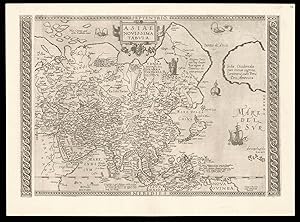
Asiae Novissima Tabula
Verlag: Gerard Smits, [c1590]., Antwerp,, 1590
Anbieter: Daniel Crouch Rare Books Ltd, London, Vereinigtes Königreich
Verbandsmitglied: ABA ILAB PBFA
Verkäuferbewertung 5 von 5 Sternen
Karte
EUR 29.811,54
EUR 23,15 Versand
Versand von Vereinigtes Königreich nach USAAnzahl: 1 verfügbar
In den WarenkorbUnrecorded second state of De Jode's map of Asia Double-page engraved map, Latin text to verso, watermark of a bunch of grapes within a shield, banner below, Briquet 13215. Unrecorded second state of Gerard de Jode's map of Asia. The map, published by Gerard de Jode in his 'Speculum Orbis Terrarum' in 1578, is not only one of the first maps to depict the Philippines, but also one of the earliest to name Singapore, here marked 'Cinapura'. The cartography is based on Mercator's seminal world map 'Nova et Aucta Orbis Terrae Descriptio', published in 1569. The work stretches from eastern Europe to the west coast of North America. Although Ortelius had included the west coast of America on his map of Southeast Asia 'Indiae Orientalis', published in 1570, its is highly unusual for maps of the whole continent to show America's coastline, with the only other sixteenth century example published in Solinus's Polyhistor of 1538. The present example has been heavily reworked and includes many additional place names, extending the map to the left and the right margins, heavily revising the west coast of America, together with the addition of two new engraved side borders. The additional names are: Mare Indicum (Indian Ocean); Mare Della China (The Sea of Japan/Korea); Aegeum Mare (Adriatic Sea); Mare del Sur (Pacific); Russia (Russia); Sarmatia Asiatica (Russia); Kondori (Russia); Europae pars Occidens (Western Europe); Candia Pars (Crete); Salonica (Thessaloniki); Belgian Mons (mountains in China); and Tangut (China). The left and right decorative borders have been erased to increase the works cartographic scope to include: in the west Thessaloniki, and Crete, and in the east a greater portion of the western coast of North America. The American coastline has been completely redrawn removing the lower section together with the place names: Tucano, Quivira, and Tiguex. The Asian coastline of the 'Stretto de Anio' (the mythical Straits of Anian) has also been remodelled. To the lower right of the map de Jode has included the 'Arcipelago d.s. Lazaro' (St Lazarus Islands). The name had originally been applied to the Philippines by Magellan, in 1521, as their first landfall on the archipelago had been on the day of the feast of St Lazarus. However as mapmakers such as Ramusio had underestimated the distance between the Marianas Islands and the Philippines, the distinction between the two were lost. Beginning with Ramusio (and copied by the likes of Ortelius) we see a tendency to push the name further east to denote islands of Micronesia, such as here. Finally de Jode has engraved two new borders, on two pieces of copper, which have here, been slighly set away from the maps copper plate. It would appear from the present example, and his map of the world 'Universi Orbis Seu Terreni Globi in Plano Effigies' - which is also known in later states - that Gerard was working on a second edition of the atlas before his death in 1591. Many of the revisions and additions to the present map are also evident on de Jode's wall map of Asia, published in around 1590 - the only surviving example of which is now housed in the Gottingen University Library. It is most likely that the publication of the wall map (Gerard also published maps of Africa, America, and Europe) acted as a catalyst for the present maps revision. Unfortunately the present state would have a very short life, as following Gerard's death in 1591 his son Cornelis in his edition of 1593 replaced all the continental maps with new plates based on the work of Gastaldi. Rarity We have been unable to trace another example of this state appearing at auction since the second world war. We have also been unable to trace any institutional examples. Gerard de Jode Gerard de Jode (1509-1591) was a cartographer and publisher. The 'Speculum Orbis Terrarum' was intended as competition for Abraham Ortelius' 'Theatrum Orbis Terrarum'. The two, who made their living partly as map-sellers, were competitors and apparently not always on good terms. It has been suggested that Ortelius was responsible for delaying the publication of de Jode's work, by using his extensive contacts to prevent de Jode's atlas being granted the necessary approbations (or privileges), as Ortelius wished to protect his own work. De Jode did not gain all the necessary approbations until 1577, some seven years after the publication of the 'Theatrum', the first copies of the 'Speculum' being sold at Plantin's shop in 1579. Ortelius' cunning plan would seem to have worked, as Plantin's records suggest that very few copies were actually sold. Although sales of de Jode's work were less than ideal, the work was evidently held in high regard, with several contemporary works citing its importance alongside the atlases of Mercator and Ortelius. Following Gerard's death in 1591, n expanded and revised edition was published by his son Cornelis in 1593.
-

Bavariae Utriusove Cum in Ferioris Tusuperioris vera et ad amusim descriptio. Bavariae Utriusove Cum in Ferioris Tusuperioris vera et ad amusim descriptio. - Gerard de Jode ? Hand-Colored Original Copperplate Engraving ? Antwerp 1593
Verlag: Gerard de Jode (15091591), Antwerp, 1593
Anbieter: Antiquariat Reinhold Berg eK Inh. R.Berg, Regensburg, Deutschland
Verkäuferbewertung 5 von 5 Sternen
Karte
Other. Hand-Colored Original Copperplate Engraving by Gerard de Jode, depicting Bavariae Utriusove Cum in Ferioris Tusuperioris vera et ad amusim descriptio. Published Antwerp, Gerard de Jode (15091591), 1593. Sheet: 349 by 457mm (13 by 18 inches). A fine and original hand-colored example of de Jode's celebrated cartographic work, documenting this region of Germany with the precision and decorative artistry characteristic of the 15900s. Gerard de Jode was a cartographer active in the 1500s, working in the tradition of European copper-engraved cartography. Their maps are valued by collectors for their historical accuracy and decorative quality.This original copperplate engraving, with original hand coloring depicts the region of Bavariae Utriusove Cum in Ferioris Tusuperioris vera et ad amusim descriptio., published in Antwerp, Gerard de Jode (15091591), 1593. A distance scale is incorporated within the cartouche or alongside it. The map records the political and geographic boundaries of the region as understood in 1593, offering a fascinating window into the history of German territorial organization. Sheet measures 349 by 457mm (13 by 18 inches). In good condition overall, with minor signs of age appropriate for a 16th-century engraving. Ready to frame. In excellent condition. 349 by 457mm (13 by 18 inches).
-

Nova et Exactissima Descriptio Nobilis Provinciae Guipuscouae in Partibus Hispaniae Sitae
Verlag: Amberes, 1593
Kunst / Grafik / Poster
Zustand: ACEPTABLE. Primer mapa impreso de Guipuzcoa. Muy raro de encontrar. Estampado para el Atlas de Gerard y Cornelis de Jode "Speculum Orbis Terrarum" en 1578-1593. Este ejemplar pertenece a la 2Ş edición más completa del Atlas edtado por el Hijo Cornelis. El Atlas no tuvo el exito deseado y fracaso su competencia con el Atlas de Ortelius. Se vendieron pocos ejemplares, aun considerandose mejores de calidad y claridad. Gerard de Jode (1509-1591) fue un grabador, cartógrafo, impresor y editor establecido en Amberes. Son conocidas sus ediciones demapas de otros cartógrafos, como Giacomo Gastaldi, Jacob van Deventer, Bartholomeus Musinus, Fernando Álvarez Seco y Abraham Ortelius, de quien publicó en 1564 un mapa del mundo en ocho hojas. Formato (cm): 26x36.
-

Zustand: ACEPTABLE. Pertenece a la 1Ş edición del Speculum orbis terrarum Pirro Ligorio authore Formato (cm): 51x38.
-

Nova et Exactissima Descriptio Nobilis Provinciae Guipuscouae in partibus Hispaniae sitae
Verlag: Amberes, 1593
Kunst / Grafik / Poster
Zustand: ACEPTABLE. Primer mapa impreso de Guipuzcoa. Muy raro de encontrar. Estampado para el Atlas de Gerard y Cornelis de Jode "Speculum Orbis Terrarum" en 1578-1593. Este ejemplar pertenece a la 2Ş edición más completa del Atlas edtado por el Hijo Cornelis. El Atlas no tuvo el exito deseado y fracaso su competencia con el Atlas de Ortelius. Se vendieron pocos ejemplares, aun considerandose mejores de calidad y claridad. Gerard de Jode (1509-1591) fue un grabador, cartógrafo, impresor y editor establecido en Amberes. Son conocidas sus ediciones de mapas de otros cartógrafos, como Giacomo Gastaldi, Jacob van Deventer, Bartholomeus Musinus, Fernando Álvarez Seco y Abraham Ortelius, de quien publicó en 1564 un mapa del mundo en ocho hojas. Formato (cm): 26x36.
-

Comitatus Venayscinensis Nova Descriptio (Provenza)
Verlag: c. 1580, Amberes, 1580
Kunst / Grafik / Poster
Zustand: ACEPTABLE. El mapa pertenece a la 2Ş edición del Speculum orbis terrarum Formato (cm): 24x30.