
Gesamtpreis (1 Artikel Artikel):
Versandziel:

jean baptiste daprčs mannevillette (20 Ergebnisse)
Direkt zu den wichtigsten Suchergebnissen
Suchfilter
Produktart
- Alle Product Types
- Bücher (4)
- Magazine & Zeitschriften (Keine weiteren Ergebnisse entsprechen dieser Verfeinerung)
- Comics (Keine weiteren Ergebnisse entsprechen dieser Verfeinerung)
- Noten (Keine weiteren Ergebnisse entsprechen dieser Verfeinerung)
- Kunst, Grafik & Poster (Keine weiteren Ergebnisse entsprechen dieser Verfeinerung)
- Fotografien (Keine weiteren Ergebnisse entsprechen dieser Verfeinerung)
- Karten (16)
- Manuskripte & Papierantiquitäten (Keine weiteren Ergebnisse entsprechen dieser Verfeinerung)
Zustand Mehr dazu
- Neu (Keine weiteren Ergebnisse entsprechen dieser Verfeinerung)
- Wie Neu, Sehr Gut oder Gut Bis Sehr Gut (Keine weiteren Ergebnisse entsprechen dieser Verfeinerung)
- Gut oder Befriedigend (2)
- Ausreichend oder Schlecht (Keine weiteren Ergebnisse entsprechen dieser Verfeinerung)
- Wie beschrieben (18)
Einband
- alle Einbände
- Hardcover (3)
- Softcover (Keine weiteren Ergebnisse entsprechen dieser Verfeinerung)
Weitere Eigenschaften
- Erstausgabe (3)
- Signiert (Keine weiteren Ergebnisse entsprechen dieser Verfeinerung)
- Schutzumschlag (Keine weiteren Ergebnisse entsprechen dieser Verfeinerung)
- Angebotsfoto (12)
Sprache (1)
Preis
- Beliebiger Preis
- Weniger als EUR 20 (Keine weiteren Ergebnisse entsprechen dieser Verfeinerung)
- EUR 20 bis EUR 45 (Keine weiteren Ergebnisse entsprechen dieser Verfeinerung)
- Mehr als EUR 45
Gratisversand
Land des Verkäufers
Verkäuferbewertung
-

LE NEPTUNE ORIENTAL: . . . / 'Instructions sur la Navigation de France aux Indes.' / 'De la Route qu'on doit faire pour aller aux Indes, suivant les differens Endroits d'ou l'on part, & ceu ou l'on veu aborder.' / 'Description de la Côte d'Afrique, depuis la Cap de Bonne Espérance jusqu'au Cap des Courans, par Manoel de Mesquitta-Pestrello, Commandant [d']une petite Frégate, qui eu fut envoyé en l'Année 1575, par ordre de Dom Sébastien, Roi de Portugal, pour Reconnoître & Examiner la Côte.' / 'Des Cotes d'Afrique depuis la Ligne équinoxiale, jusqu'au Détroit de Babel-Mandel.' / 'Mémoire sur la Carte des Mers de la Chine, par M. Alexandre D'Alrymple, Écuyer.' / . . . - LARGE-PAPER COPY OF THE COMPLETE TEXT, in the original Binding; WITHOUT MAPS. . . [Le Neptune Oriental, ou Routier General des Côtes des Indes Orientales et de la Chine]
Verlag: Ŕ Paris, chez Demonville & Malassis, Imprimeur-Libraire de l'Académie Francoise, . . . et ŕ Brest, chez Malassis, Imprimeur de la Marine, M. DCC LXXV. (1775), 1775
Anbieter: C O - L I B R I , Bremen - Berlin ; Deutschland / Germany ., Berlin, Deutschland
Verkäuferbewertung 5 von 5 Sternen

Erstausgabe
EUR 1.650,00
Währung umrechnenEUR 26,13 für den Versand von Deutschland nach USAAnzahl: 1 verfügbar
In den Warenkorb1 blank sheet, singleside printed titlesheet, x[10] sheets 'Preface'; 52 sheets of text consisting of 194 [+14] vertically halfpage columns of 'Instructions . . .'(c. [1]-38); 'De la Route . . .'(c. 39-47/48); 'Description de la Côte d'Afrique, . . .'(c. 47/48-64); 'Des Cotes d'Afrique . . .'(c. 65-191); 'Mémoire sur la Carte . . .'(c. 191-194); 'Tables des Variations' (c. [195]-[199/200]); 'Avis au relieur. . .'(c. [199/200]); 'Table des Articles' (c. [201]-[202]); 'Extraits des Régistres de L'Académie Royale de Marine du 9 Mars 1775'; 'Rapport de >Neptune Oriental<' (c. [203]-[207/208]); 'Privilčge du Roi' (c. [207/208]); except 1st blank and titlesheet re. all printed on thick and untrimmed blueish large paper. - Thick colour-marbled paper covered cardbord-binding of the period with gilt-titled and -decorated leather spinelabel; imperial-folio (ca. 59 x 44 x 5 cm; ca. 4,5 kg.). *** SECOND EDITION, IN A ORIGINAL BINDING OF THE PERIOD; text complete, lacking all maps (not removed by us). - Shortly after its publication the 1745 first edition of 'Le Neptune Oriental' most copies were destroyed by the French Admiralty to keep the secrets of East Indian navigation. 30 years later, having been appointed 'Director of Chart at L'Orient' in 1762 by the Compagnie des Indes and conferred the 'Order of St. Michael' in 1767 by King Louis XV, Mannevillette, together with his friend Alexander Dalrymple, updated his original work with new and improved charts and republished his opus magnum in a greatly expanded format. --- Corners of the binding slightly rubbed; A VERY GOOD COPY.
-
EUR 39.616,58
Währung umrechnenKostenlos für den Versand innerhalb von/der USAAnzahl: 1 verfügbar
In den WarenkorbHardcover. Zustand: Very good. Second. Second edition, enlarged. Paris: Chez Demonville & Brest: Chez Malassis, 1775. Folio (21 5/8" x 16 13/16", 548mm x 426mm). [Full collation available.] With an engraved frontispiece (painted by Boucher, engraved by Tilliard), an engraved head-piece to the dedication and 63 engraved charts (29 folding, 34 single). Bound in contemporary cat's paw calf with a triple gilt fillet border. On the spine, five raised bands with a dashed gilt roll. In the panels, gilt florals. Title gilt to red morocco in the second panel. Gilt roll to the edges of the boards. All edges of the text-block speckled red. Spine and fore-corners restored. Some wear to the boards at the acid-spots. Moderate fore-edge dampstain to charts 51, 51bis and 52, and lower-edge marginal dampstain to a several plates. Some numbers have been pasted over, as have sections of some charts. Altogether quite a clean and robust set of charts on the original stubs. D'Apres de Mannevillette (1707-1780), unlike so many of his cartographic colleagues, was a proper ship's captain and navigator. As a captain of the French East-India Company, he was the first Frenchman to use the octant, which allowed him to make significant advances over previous charts and maps throughout southern Asia. Indeed, so much did his publications surpass his peers' that his atlases became de rigeur in the cabins of nearly all French ships in the second half of the XVIIIc. Although the king and then the revolution would hamper French colonial holdings in eastern India and southeast Asia broadly, d'Apres's maps would guide their rivals and successors. The first edition of Neptune Oriental (1745) contained only about two dozen charts; d'Apres worked for three additional decades to add some forty maps. As often with atlases of this period, the number of charts was variable depending on the purse and interests of the purchaser. The copy inscribed by d'Apres to George III (now in the BL) has 59 charts; those in the BnF have between 60 and 69 plates. It seems that no copy adheres to the list of plates supplied for the binder. The present copy with its 63 charts lines up fairly well; no. 10 is "ŕ placer" and lacking, no. 19 is bound after 20, and no. 46 is lacking numerically but the chart itself, "Carte de l'isle to Java" is present as no. 44. In all, this is quite a robust collection. The chart of Hong Kong (53) deserves special mention. It benefitted from Dalrymple's surveys through 1760, far surpassing previous charts, and almost indicates its separation from the mainland; the northeast was clearly too rocky to allow for an accurate account. Phillips 3165, Shirley BL Atlases 1067-1068.
-
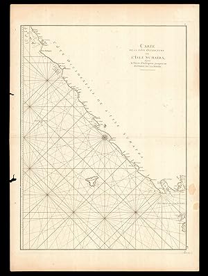
Carte de la Cote Occidentale de l'Isle Sumatra depuis la Ligne Equinoctiale jusqu'au Detroit de la Sonde
Verlag: Paris, 1775
Anbieter: Clive A. Burden Ltd., Chalfont St. Giles, BUCKS, Vereinigtes Königreich
Verkäuferbewertung 5 von 5 Sternen
Karte
EUR 147,96
Währung umrechnenEUR 25,45 für den Versand von Vereinigtes Königreich nach USAAnzahl: 1 verfügbar
In den WarenkorbNo binding. 660 x 480 mm., in good condition. A good large scale chart of the south west of Sumatra in Indonesia. It covers the territory from the Straits of Sunda past Bengkulu further north. The material collected for 'Le Neptune Oriental' was approved by the French Compagnie des Indes. D'Apres de Mannevillette was one of the first Hydrographers of France and an accomplished navigator. Born in Le Havre to a captain in the French West India Company he made a voyage to the Caribbean in 1726. He showed an early interest in navigation and was one of the first Frenchmen to use Hadley's quadrant and was later in life a friend of Dalrymple. Upon the atlas' publication it was highly commended by everyone. Updated at various times after initial publication in 1745 it was expanded considerably in 1775 when this chart was introduced. NMM 204 not listed; Shirley M.Apr 1c.
-
Carte Du Detroit De La Sonde depuis la Pointe de Winerou jusqu'a l'Isle du Nord
Verlag: Paris, 1745
Anbieter: Clive A. Burden Ltd., Chalfont St. Giles, BUCKS, Vereinigtes Königreich
Verkäuferbewertung 5 von 5 Sternen
Karte
EUR 171,63
Währung umrechnenEUR 25,45 für den Versand von Vereinigtes Königreich nach USAAnzahl: 1 verfügbar
In den WarenkorbNo binding. 680 x 480 mm, with two small tears in the right margin, one just touching the neatline, both repaired otherwise in good condition. A nice detailed chart of the coast of the Straits of Sunda with Sumatra to the upper left and Java, both in Indonesia. The important colonial port of Bantam is depicted on the north coast of Java. The inset lower left features a 'Plande la Baye de l'Isle de Mew ou Cantaye', a small island off the western coast of Java, in what today is the Ujung Kulon National Park. Three coastal profiles are inserted in Java. The material collected for 'Le Neptune Oriental' was approved by the French Compagnie des Indes. D'Apres de Mannevillette was one of the first Hydrographers of France and an accomplished navigator. Born in Le Havre to a captain in the French West India Company he made a voyage to the Caribbean in 1726. He showed an early interest in navigation and was one of the first Frenchmen to use Hadley's quadrant and was later in life a friend of Dalrymple. Upon the atlas' publication it was highly commended by everyone. Updated at various times after initial publication in 1745 it was expanded considerably in 1775. NMM 203 no. 15; Shirley M.Apr 1c.
-

Carte de la Cote Orientale du Golfe de Bengale
Verlag: Paris, 1745
Anbieter: Clive A. Burden Ltd., Chalfont St. Giles, BUCKS, Vereinigtes Königreich
Verkäuferbewertung 5 von 5 Sternen
Karte
EUR 177,55
Währung umrechnenEUR 25,45 für den Versand von Vereinigtes Königreich nach USAAnzahl: 1 verfügbar
In den WarenkorbNo binding. 480 x 330 mm., with one or two light marks lower right, just into the image, otherwise in good condition. A nice chart of the northern portion of the Gulf of Bengal depicting in the north Luckipore and Islamabad. The material collected for 'Le Neptune Oriental' was approved by the French Compagnie des Indes. D'Apres de Mannevillette was one of the first Hydrographers of France and an accomplished navigator. Born in Le Havre to a captain in the French West India Company he made a voyage to the Caribbean in 1726. He showed an early interest in navigation and was one of the first Frenchmen to use Hadley's quadrant and was later in life a friend of Dalrymple. Upon the atlas' publication it was highly commended by everyone. Updated at various times after initial publication in 1745 it was expanded considerably in 1775. NMM 203 no. 9; Shirley M.Apr 1c.
-

Plan Du Detroit De Banca
Verlag: Brussels, 1745
Anbieter: Clive A. Burden Ltd., Chalfont St. Giles, BUCKS, Vereinigtes Königreich
Verkäuferbewertung 5 von 5 Sternen
Karte
EUR 195,30
Währung umrechnenEUR 25,45 für den Versand von Vereinigtes Königreich nach USAAnzahl: 1 verfügbar
In den WarenkorbNo binding. 480 x 330 mm., early wash colour, with pasted over section containing new data on the north and east shores of Banca, in good condition. A nice detailed chart of the coast of south east coast of Sumatra or Indonesia with the Island of Banca (Bangka) offshore. The material collected for 'Le Neptune Oriental' was approved by the French Compagnie des Indes. D'Apres de Mannevillette was one of the first Hydrographers of France and an accomplished navigator. Born in Le Havre to a captain in the French West India Company he made a voyage to the Caribbean in 1726. He showed an early interest in navigation and was one of the first Frenchmen to use Hadley's quadrant and was later in life a friend of Dalrymple. Upon the atlas' publication it was highly commended by everyone. Updated at various times after initial publication in 1745 it was expanded considerably in 1775. The inset upper right features a 'Petit Plan du Detroit a l'Est de Banca'. NMM 203 no. 18; Shirley M.Apr 1c.
-
Carte Des Isles Nicobar
Verlag: Paris, 1775
Anbieter: Clive A. Burden Ltd., Chalfont St. Giles, BUCKS, Vereinigtes Königreich
Verkäuferbewertung 5 von 5 Sternen
Karte
EUR 207,14
Währung umrechnenEUR 25,45 für den Versand von Vereinigtes Königreich nach USAAnzahl: 1 verfügbar
In den WarenkorbNo binding. 475 x 325 mm., in early outline colour, good condition. A good large scale chart of the Nicobar Islands in the Indian Ocean. The material collected for 'Le Neptune Oriental' was approved by the French Compagnie des Indes. D'Apres de Mannevillette was one of the first Hydrographers of France and an accomplished navigator. Born in Le Havre to a captain in the French West India Company he made a voyage to the Caribbean in 1726. He showed an early interest in navigation and was one of the first Frenchmen to use Hadley's quadrant and was later in life a friend of Dalrymple. Upon the atlas' publication it was highly commended by everyone. Updated at various times after initial publication in 1745 it was expanded considerably in 1775 when this chart was introduced. NMM 204 no. 53; Shirley M.Apr 1c.
-

Carte de la Cote Occidentale de L'Isle Sumatra depuis la Ligne Equinoctiale jusqu'au Detroit de la Sonde
Verlag: Paris, 1745
Anbieter: Clive A. Burden Ltd., Chalfont St. Giles, BUCKS, Vereinigtes Königreich
Verkäuferbewertung 5 von 5 Sternen
Karte
EUR 207,14
Währung umrechnenEUR 25,45 für den Versand von Vereinigtes Königreich nach USAAnzahl: 1 verfügbar
In den WarenkorbNo binding. 660 x 480 mm., in early wash colour and in good condition. A nice detailed chart of the west coast of Sumatra with Padang near the top leading southwards towards the Sunda Straits taking in Indrapour. The material collected for 'Le Neptune Oriental' was approved by the French Compagnie des Indes. D'Apres de Mannevillette was one of the first Hydrographers of France and an accomplished navigator. Born in Le Havre to a captain in the French West India Company he made a voyage to the Caribbean in 1726. He showed an early interest in navigation and was one of the first Frenchmen to use Hadley's quadrant and was later in life a friend of Dalrymple. Upon the atlas' publication it was highly commended by everyone. Updated at various times after initial publication in 1745 it was expanded considerably in 1775. This example is updated with paste-overs for the region of Indrapour and the island of Trompeuse. NMM 203; Shirley M.Apr 1c.
-
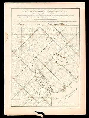
Plan de la Rade D'Achem et des Isles Circonvoisines
Verlag: Paris, 1745
Anbieter: Clive A. Burden Ltd., Chalfont St. Giles, BUCKS, Vereinigtes Königreich
Verkäuferbewertung 5 von 5 Sternen
Karte
EUR 207,14
Währung umrechnenEUR 25,45 für den Versand von Vereinigtes Königreich nach USAAnzahl: 1 verfügbar
In den WarenkorbNo binding. 480 x 335 mm., fine early wash colour. Good condition. A nice detailed chart of the coast of Sumatra or Indonesia centred on BANDA ACEH, the scene of the devastating tsunami which struck the region on 26 December 2004. The material collected for 'Le Neptune Oriental' was approved by the French Compagnie des Indes. D'Apres de Mannevillette was one of the first Hydrographers of France and an accomplished navigator. Born in Le Havre to a captain in the French West India Company he made a voyage to the Caribbean in 1726. He showed an early interest in navigation and was one of the first Frenchmen to use Hadley's quadrant and was later in life a friend of Dalrymple. Upon the atlas' publication it was highly commended by everyone. Updated at various times after initial publication in 1745 it was expanded considerably in 1775. NMM 203 no. 11; Shirley M.Apr 1c.
-

Nouveau Plan des Detroits, Situes a l'Est de Java et de Madura, Nommes Communement les Detroits de Bali et d'entre Pondi et Respondi .
Verlag: Paris, 1775
Anbieter: Clive A. Burden Ltd., Chalfont St. Giles, BUCKS, Vereinigtes Königreich
Verkäuferbewertung 5 von 5 Sternen
Karte
EUR 207,14
Währung umrechnenEUR 25,45 für den Versand von Vereinigtes Königreich nach USAAnzahl: 1 verfügbar
In den WarenkorbNo binding. 480 x 330 mm., modern outline colour, tear in lower left corner repaired, otherwise in good condition. A good large scale chart of the east end of Java and the western part of Bali. An inset lower left features a 'Plan de la Baye de Ballambouang'. The material collected for 'Le Neptune Oriental' was approved by the French Compagnie des Indes. D'Apres de Mannevillette was one of the first Hydrographers of France and an accomplished navigator. Born in Le Havre to a captain in the French West India Company he made a voyage to the Caribbean in 1726. He showed an early interest in navigation and was one of the first Frenchmen to use Hadley's quadrant and was later in life a friend of Dalrymple. Upon the atlas' publication it was highly commended by everyone. Updated at various times after initial publication in 1745 it was expanded considerably in 1775 when this chart was introduced. NMM 204 no. 55; Shirley M.Apr 1c.
-
Plan de la Rade d'Achem et des Isles Circonvoisines Situees a la partie du Nord-ouest de Sumatra.
Verlag: Chez Demonville, Imprimeur-Libraire de l'Academie Francoise; Chez Malassis, Imprimeur-Libraire de la Marine, 1775]., [Paris and Brest,, 1775
Anbieter: Daniel Crouch Rare Books Ltd, London, Vereinigtes Königreich
Verbandsmitglied: ABA ILAB PBFA
Verkäuferbewertung 4 von 5 Sternen

Karte
EUR 236,73
Währung umrechnenEUR 22,98 für den Versand von Vereinigtes Königreich nach USAAnzahl: 1 verfügbar
In den WarenkorbPasse de Surate to the northwest tip of Sumatra Engraved chart, some marginal worming. Chart of the safe-passage through the roads into the port of Banda Aceh, Sumatra, and the islands of Pulau Weh, Breueh and Nasi, with a coastal profile of the southwestern approach, called "Passe de Surate" to "Pte du Roi". A caption beneath the title warns that even though vessels are sheltered in these roads from the winds of the Northeast monsoon, the winds from the Northwest, can be violent and cause large swells, which "is why ships need to have good cables and good anchors to be safe there". From the second edition of 'Le Neptune Oriental', D'Apres de Mannevillette's rare sea atlas. A famous French sailor and hydrographer, d'Apres de Mannevillette (1707-1780), was the son of a French sea-captain and, at the age of twelve, sailed with his father to Bengal. After his return, he studied astronomy and geometry in Paris. During a long career in the French merchant marine, starting as fourth officer in 1726, he visited many parts of the world and collected valuable navigational information. He studied under the famous Guillaume Delisle, the King's geographer. He experimented with improved scientific instruments and navigational methods. During his voyage to China in 1728 he was the first to use the octant (or Hadley's quadrant) on a voyage to measure latitudes, and determined longitudes by measuring the angular distance between the moon and sun and succeeded in correcting the latitudes of many place. He first visited the Cape of Good Hope in 1737 while on his way to China as a lieutenant aboard the Prince de Conti. During his many voyages d'Apres de Mannevillette created a number of charts for a hydrographic atlas which, with the support of the Academie des Sciences, was published in Paris in 1745 under the title 'Le Neptune Oriental' with 25 maps. The atlas contained charts of the route to China: the Red Sea, the coasts of India, Malaya, the northern parts of Indonesia, Indochina and China. "The new sea atlas quickly found its way into the pilot cabins of ships of several nations, and its 22 charts were immediately recognised as being superior to all previous maps of Southeast Asian coasts" (Suárez p.238). In 1762 the Compagnie des Indes (French East India Company) appointed D'Apres de Mannevillette as director of maps and plans at Lorient, and five years later he was decorated with the order of St. Michael. In 1765, he published his 'Memoire sur la navigation de France aux Indes', which was translated into English (1769) and Dutch (1770), and served all who sailed round the Cape to the East. The 1768 edition includes descriptions of Tristan da Cunha, False Bay, and Simon's Bay. Mannevillette spent 30 years, often in concert with his friend, and eminent British hydrographer, Alexander Dalrymple, working on the second edition of his maritime atlas. It was substantially enlarged from the first edition of 1745 and was heavily used throughout the end of the eighteenth and beginning of the nineteenth centuries. Most maps are now corrected with paste-on labels. This comprehensive atlas was used on all French ships for navigating the Indian Ocean. It replaced the "English Pilot" published by John Thornton in 1700 and the charts of the van Keulens, the hydrographers of the Dutch East India Company. The second edition eventually required a supplement, published posthumously in 1781 and reissued in 1797.
-
Carte de la Cote Occidentale de l'Isle Sumatra, depuis la Pointe d'Indrapour jusques au Detroit de la Sonde.
Verlag: Chez Demonville, Imprimeur-Libraire de l'Academie Francoise; Chez Malassis, Imprimeur-Libraire de la Marine, 1775]., [Paris and Brest,, 1775
Anbieter: Daniel Crouch Rare Books Ltd, London, Vereinigtes Königreich
Verbandsmitglied: ABA ILAB PBFA
Verkäuferbewertung 4 von 5 Sternen
Karte
EUR 260,40
Währung umrechnenEUR 22,98 für den Versand von Vereinigtes Königreich nach USAAnzahl: 1 verfügbar
In den WarenkorbSouthern entrance to the Sunda Strait Engraved chart, some marginal worming. Large-scale chart, of the southwest coast of Sumatra and the entrance to the Sunda Strait. From the second edition of 'Le Neptune Oriental', D'Apres de Mannevillette's rare sea atlas. A famous French sailor and hydrographer, d'Apres de Mannevillette (1707-1780), was the son of a French sea-captain and, at the age of twelve, sailed with his father to Bengal. After his return, he studied astronomy and geometry in Paris. During a long career in the French merchant marine, starting as fourth officer in 1726, he visited many parts of the world and collected valuable navigational information. He studied under the famous Guillaume Delisle, the King's geographer. He experimented with improved scientific instruments and navigational methods. During his voyage to China in 1728 he was the first to use the octant (or Hadley's quadrant) on a voyage to measure latitudes, and determined longitudes by measuring the angular distance between the moon and sun and succeeded in correcting the latitudes of many place. He first visited the Cape of Good Hope in 1737 while on his way to China as a lieutenant aboard the Prince de Conti. During his many voyages d'Apres de Mannevillette created a number of charts for a hydrographic atlas which, with the support of the Academie des Sciences, was published in Paris in 1745 under the title 'Le Neptune Oriental' with 25 maps. The atlas contained charts of the route to China: the Red Sea, the coasts of India, Malaya, the northern parts of Indonesia, Indochina and China. "The new sea atlas quickly found its way into the pilot cabins of ships of several nations, and its 22 charts were immediately recognised as being superior to all previous maps of Southeast Asian coasts" (Suárez p.238). In 1762 the Compagnie des Indes (French East India Company) appointed D'Apres de Mannevillette as director of maps and plans at Lorient, and five years later he was decorated with the order of St. Michael. In 1765, he published his 'Memoire sur la navigation de France aux Indes', which was translated into English (1769) and Dutch (1770), and served all who sailed round the Cape to the East. The 1768 edition includes descriptions of Tristan da Cunha, False Bay, and Simon's Bay. Mannevillette spent 30 years, often in concert with his friend, and eminent British hydrographer, Alexander Dalrymple, working on the second edition of his maritime atlas. It was substantially enlarged from the first edition of 1745 and was heavily used throughout the end of the eighteenth and beginning of the nineteenth centuries. Most maps are now corrected with paste-on labels. This comprehensive atlas was used on all French ships for navigating the Indian Ocean. It replaced the "English Pilot" published by John Thornton in 1700 and the charts of the van Keulens, the hydrographers of the Dutch East India Company. The second edition eventually required a supplement, published posthumously in 1781 and reissued in 1797.
-
Carte du Detroit de la Sonde depuis la Pointe de Winerou jusqu'a l'Isle du Nord.
Verlag: Chez Demonville, Imprimeur-Libraire de l'Academie Francoise; Chez Malassis, Imprimeur-Libraire de la Marine, 1775]., [Paris and Brest, 1775
Anbieter: Daniel Crouch Rare Books Ltd, London, Vereinigtes Königreich
Verbandsmitglied: ABA ILAB PBFA
Verkäuferbewertung 4 von 5 Sternen
Karte
EUR 295,91
Währung umrechnenEUR 22,98 für den Versand von Vereinigtes Königreich nach USAAnzahl: 1 verfügbar
In den WarenkorbThe Sunda Strait Engraved chart, one or two pale stains. A navigable chart of the Sunda Strait, the southeast cost of Sumatra, and the western tip of Java. With an inset of the island of the "L'Isle de Mew ou Cantaye", coastal profiles and soundings. From the second edition of 'Le Neptune Oriental', D'Apres de Mannevillette's rare sea atlas. A famous French sailor and hydrographer, d'Apres de Mannevillette (1707-1780), was the son of a French sea-captain and, at the age of twelve, sailed with his father to Bengal. After his return, he studied astronomy and geometry in Paris. During a long career in the French merchant marine, starting as fourth officer in 1726, he visited many parts of the world and collected valuable navigational information. He studied under the famous Guillaume Delisle, the King's geographer. He experimented with improved scientific instruments and navigational methods. During his voyage to China in 1728 he was the first to use the octant (or Hadley's quadrant) on a voyage to measure latitudes, and determined longitudes by measuring the angular distance between the moon and sun and succeeded in correcting the latitudes of many place. He first visited the Cape of Good Hope in 1737 while on his way to China as a lieutenant aboard the Prince de Conti. During his many voyages d'Apres de Mannevillette created a number of charts for a hydrographic atlas which, with the support of the Academie des Sciences, was published in Paris in 1745 under the title 'Le Neptune Oriental' with 25 maps. The atlas contained charts of the route to China: the Red Sea, the coasts of India, Malaya, the northern parts of Indonesia, Indochina and China. "The new sea atlas quickly found its way into the pilot cabins of ships of several nations, and its 22 charts were immediately recognised as being superior to all previous maps of Southeast Asian coasts" (Suárez p.238). In 1762 the Compagnie des Indes (French East India Company) appointed D'Apres de Mannevillette as director of maps and plans at Lorient, and five years later he was decorated with the order of St. Michael. In 1765, he published his 'Memoire sur la navigation de France aux Indes', which was translated into English (1769) and Dutch (1770), and served all who sailed round the Cape to the East. The 1768 edition includes descriptions of Tristan da Cunha, False Bay, and Simon's Bay. Mannevillette spent 30 years, often in concert with his friend, and eminent British hydrographer, Alexander Dalrymple, working on the second edition of his maritime atlas. It was substantially enlarged from the first edition of 1745 and was heavily used throughout the end of the eighteenth and beginning of the nineteenth centuries. Most maps are now corrected with paste-on labels. This comprehensive atlas was used on all French ships for navigating the Indian Ocean. It replaced the "English Pilot" published by John Thornton in 1700 and the charts of the van Keulens, the hydrographers of the Dutch East India Company. The second edition eventually required a supplement, published posthumously in 1781 and reissued in 1797.
-

Nouveau Plan des Detroits, situes a l'Est de Java et de Madura, nommes communement les Detroits de Bali, e d'entre Pondi et Respondi
Verlag: Chez Demonville, Imprimeur-Libraire de l'Academie Francoise; Chez Malassis, Imprimeur-Libraire de la Marine, 1775]., [Paris and Brest,, 1775
Anbieter: Daniel Crouch Rare Books Ltd, London, Vereinigtes Königreich
Verbandsmitglied: ABA ILAB PBFA
Verkäuferbewertung 4 von 5 Sternen
Karte
EUR 355,09
Währung umrechnenEUR 22,98 für den Versand von Vereinigtes Königreich nach USAAnzahl: 1 verfügbar
In den WarenkorbThe Bali Strait Engraved chart, some marginal wormtracks. Navigable chart of the Bali Strait, between Java and Bali, Indonesia, and including the eastern end of Pulau Madura, Gili Iyang and Pulau Sapudi. With an inset chart 'Plan de la Baye de Ballambouang levée sur le Vaisseau le Royal George en 1766', and a number of coastal profiles. A note beneath the title credits several surveys by English and French vessels, made during the 1750s and 1760s for the information in this chart. From the second edition of 'Le Neptune Oriental', D'Apres de Mannevillette's rare sea atlas. A famous French sailor and hydrographer, d'Apres de Mannevillette (1707-1780), was the son of a French sea-captain and, at the age of twelve, sailed with his father to Bengal. After his return, he studied astronomy and geometry in Paris. During a long career in the French merchant marine, starting as fourth officer in 1726, he visited many parts of the world and collected valuable navigational information. He studied under the famous Guillaume Delisle, the King's geographer. He experimented with improved scientific instruments and navigational methods. During his voyage to China in 1728 he was the first to use the octant (or Hadley's quadrant) on a voyage to measure latitudes, and determined longitudes by measuring the angular distance between the moon and sun and succeeded in correcting the latitudes of many place. He first visited the Cape of Good Hope in 1737 while on his way to China as a lieutenant aboard the Prince de Conti. During his many voyages d'Apres de Mannevillette created a number of charts for a hydrographic atlas which, with the support of the Academie des Sciences, was published in Paris in 1745 under the title 'Le Neptune Oriental' with 25 maps. The atlas contained charts of the route to China: the Red Sea, the coasts of India, Malaya, the northern parts of Indonesia, Indochina and China. "The new sea atlas quickly found its way into the pilot cabins of ships of several nations, and its 22 charts were immediately recognised as being superior to all previous maps of Southeast Asian coasts" (Suárez p.238). In 1762 the Compagnie des Indes (French East India Company) appointed D'Apres de Mannevillette as director of maps and plans at Lorient, and five years later he was decorated with the order of St. Michael. In 1765, he published his 'Memoire sur la navigation de France aux Indes', which was translated into English (1769) and Dutch (1770), and served all who sailed round the Cape to the East. The 1768 edition includes descriptions of Tristan da Cunha, False Bay, and Simon's Bay. Mannevillette spent 30 years, often in concert with his friend, and eminent British hydrographer, Alexander Dalrymple, working on the second edition of his maritime atlas. It was substantially enlarged from the first edition of 1745 and was heavily used throughout the end of the eighteenth and beginning of the nineteenth centuries. Most maps are now corrected with paste-on labels. This comprehensive atlas was used on all French ships for navigating the Indian Ocean. It replaced the "English Pilot" published by John Thornton in 1700 and the charts of the van Keulens, the hydrographers of the Dutch East India Company. The second edition eventually required a supplement, published posthumously in 1781 and reissued in 1797.
-

Plan du Détroit de Banca, dressé sur les remarques et les observations les plus éxactes des Navigateurs
Verlag: Chez Demonville, Imprimeur-Libraire de l'Academie Francoise; Chez Malassis, Imprimeur-Libraire de la Marine, 1775]., [Paris and Brest,, 1775
Anbieter: Daniel Crouch Rare Books Ltd, London, Vereinigtes Königreich
Verbandsmitglied: ABA ILAB PBFA
Verkäuferbewertung 4 von 5 Sternen
Karte
EUR 355,09
Währung umrechnenEUR 22,98 für den Versand von Vereinigtes Königreich nach USAAnzahl: 1 verfügbar
In den WarenkorbThe Bangka Strait Engraved chart. Navigable chart of the Bangka Strait, off the east coast of Sumatra, with an inset of the strait between Bangka and Belitung, 'Petit plan du détroit ŕ l'Est de Banca,' upper right. From the second edition of 'Le Neptune Oriental', D'Apres de Mannevillette's rare sea atlas. A famous French sailor and hydrographer, d'Apres de Mannevillette (1707-1780), was the son of a French sea-captain and, at the age of twelve, sailed with his father to Bengal. After his return, he studied astronomy and geometry in Paris. During a long career in the French merchant marine, starting as fourth officer in 1726, he visited many parts of the world and collected valuable navigational information. He studied under the famous Guillaume Delisle, the King's geographer. He experimented with improved scientific instruments and navigational methods. During his voyage to China in 1728 he was the first to use the octant (or Hadley's quadrant) on a voyage to measure latitudes, and determined longitudes by measuring the angular distance between the moon and sun and succeeded in correcting the latitudes of many place. He first visited the Cape of Good Hope in 1737 while on his way to China as a lieutenant aboard the Prince de Conti. During his many voyages d'Apres de Mannevillette created a number of charts for a hydrographic atlas which, with the support of the Academie des Sciences, was published in Paris in 1745 under the title 'Le Neptune Oriental' with 25 maps. The atlas contained charts of the route to China: the Red Sea, the coasts of India, Malaya, the northern parts of Indonesia, Indochina and China. "The new sea atlas quickly found its way into the pilot cabins of ships of several nations, and its 22 charts were immediately recognised as being superior to all previous maps of Southeast Asian coasts" (Suárez p.238). In 1762 the Compagnie des Indes (French East India Company) appointed D'Apres de Mannevillette as director of maps and plans at Lorient, and five years later he was decorated with the order of St. Michael. In 1765, he published his 'Memoire sur la navigation de France aux Indes', which was translated into English (1769) and Dutch (1770), and served all who sailed round the Cape to the East. The 1768 edition includes descriptions of Tristan da Cunha, False Bay, and Simon's Bay. Mannevillette spent 30 years, often in concert with his friend, and eminent British hydrographer, Alexander Dalrymple, working on the second edition of his maritime atlas. It was substantially enlarged from the first edition of 1745 and was heavily used throughout the end of the eighteenth and beginning of the nineteenth centuries. Most maps are now corrected with paste-on labels. This comprehensive atlas was used on all French ships for navigating the Indian Ocean. It replaced the "English Pilot" published by John Thornton in 1700 and the charts of the van Keulens, the hydrographers of the Dutch East India Company. The second edition eventually required a supplement, published posthumously in 1781 and reissued in 1797.
-
Carte de la partie comprise entre la Sortie du Detroit de Malac le Detroit de Banca e l'Isle Borneo.
Verlag: Chez Demonville, Imprimeur-Libraire de l'Academie Francoise; Chez Malassis, Imprimeur-Libraire de la Marine, 1775]., [Paris and Brest, 1775
Anbieter: Daniel Crouch Rare Books Ltd, London, Vereinigtes Königreich
Verbandsmitglied: ABA ILAB PBFA
Verkäuferbewertung 4 von 5 Sternen
Karte
EUR 414,27
Währung umrechnenEUR 22,98 für den Versand von Vereinigtes Königreich nach USAAnzahl: 1 verfügbar
In den WarenkorbThe sea between Sumatra and Borneo Engraved chart. Navigable chart of the waters between Sumatra and Borneo, complete with routes and soundings to 1773. From the second edition of 'Le Neptune Oriental', D'Apres de Mannevillette's rare sea atlas. A famous French sailor and hydrographer, d'Apres de Mannevillette (1707-1780), was the son of a French sea-captain and, at the age of twelve, sailed with his father to Bengal. After his return, he studied astronomy and geometry in Paris. During a long career in the French merchant marine, starting as fourth officer in 1726, he visited many parts of the world and collected valuable navigational information. He studied under the famous Guillaume Delisle, the King's geographer. He experimented with improved scientific instruments and navigational methods. During his voyage to China in 1728 he was the first to use the octant (or Hadley's quadrant) on a voyage to measure latitudes, and determined longitudes by measuring the angular distance between the moon and sun and succeeded in correcting the latitudes of many place. He first visited the Cape of Good Hope in 1737 while on his way to China as a lieutenant aboard the Prince de Conti. During his many voyages d'Apres de Mannevillette created a number of charts for a hydrographic atlas which, with the support of the Academie des Sciences, was published in Paris in 1745 under the title 'Le Neptune Oriental' with 25 maps. The atlas contained charts of the route to China: the Red Sea, the coasts of India, Malaya, the northern parts of Indonesia, Indochina and China. "The new sea atlas quickly found its way into the pilot cabins of ships of several nations, and its 22 charts were immediately recognised as being superior to all previous maps of Southeast Asian coasts" (Suárez p.238). In 1762 the Compagnie des Indes (French East India Company) appointed D'Apres de Mannevillette as director of maps and plans at Lorient, and five years later he was decorated with the order of St. Michael. In 1765, he published his 'Memoire sur la navigation de France aux Indes', which was translated into English (1769) and Dutch (1770), and served all who sailed round the Cape to the East. The 1768 edition includes descriptions of Tristan da Cunha, False Bay, and Simon's Bay. Mannevillette spent 30 years, often in concert with his friend, and eminent British hydrographer, Alexander Dalrymple, working on the second edition of his maritime atlas. It was substantially enlarged from the first edition of 1745 and was heavily used throughout the end of the eighteenth and beginning of the nineteenth centuries. Most maps are now corrected with paste-on labels. This comprehensive atlas was used on all French ships for navigating the Indian Ocean. It replaced the "English Pilot" published by John Thornton in 1700 and the charts of the van Keulens, the hydrographers of the Dutch East India Company. The second edition eventually required a supplement, published posthumously in 1781 and reissued in 1797.
-
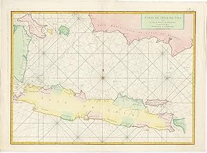
Antique Map of Java (Indonesia) by J.B. de Mannevillette (1745)
Verlag: Jean-Baptiste d'Aprčs de Mannevillette, 1745
Anbieter: Bartele Gallery - The Netherlands, Langweer, FRL, Niederlande
Verkäuferbewertung 5 von 5 Sternen
Karte
EUR 564,50
Währung umrechnenEUR 17,00 für den Versand von Niederlande nach USAAnzahl: 1 verfügbar
In den WarenkorbNo Binding. Zustand: Good. Antique map titled 'Carte de l'Isle de Java (.)'. A mid-18th century French sea chart in modern hand colour of Java Island with south-east Sumatra, Banca Island and the south coast of Borneo by the French hydrographer Jean-Baptiste d Apres de Mannevillette (1707-80), a contemporary of Jacques Nicolas Bellin and an accomplished navigator in the Compagnie des Indes. After studying mathematics in Paris he gained early experience of the sea and during many voyages assembled a collection of material for a hydrographic atlas that was published in Paris with the support of the Academie des Sciences in 1745 under the title Le Neptune Oriental. The atlas contained 22 charts, including the chart of Java that was based on accurate and meticulous surveys. Great condition. Some minor defects from handling. Please study imge carefully. Overall size: 75 x 55.5 cm. Image size: 67 x 49 cm. The collection of Bartele Gallery includes over 50,000 authentic antique maps, sea charts, prints and books. Our Abebooks store includes a selection of maps, prints and books for SALE prices. Please visit our other online sales channels to explore our complete collection of original antique maps and prints!
-

Nouvelle Carte des Mers Comprises entre Le Detroit de Banca et P.o Timon, avec la partie Orientale du Detroit de Malac.
Verlag: Chez Demonville, Imprimeur-Libraire de l'Academie Francoise; Chez Malassis, Imprimeur-Libraire de la Marine, 1775]., [Paris and Brest,, 1775
Anbieter: Daniel Crouch Rare Books Ltd, London, Vereinigtes Königreich
Verbandsmitglied: ABA ILAB PBFA
Verkäuferbewertung 4 von 5 Sternen
Karte
EUR 1.302,01
Währung umrechnenEUR 22,98 für den Versand von Vereinigtes Königreich nach USAAnzahl: 1 verfügbar
In den WarenkorbI. de Jatana ou de Saincapour Engraved chart. Oriented with west to the top, this chart of the southern tip of the Malay Peninsula, part of the Malacca Strait, and Singapore Strait, shows Singapore as an island, "I. de Jatana ou de Saincapour". With numerous coastal profiles and an inset 'Plan de l'Anse, du Sud Est de Pulo Timon et de sa Rade'. While many of the treacherous islands of the navigable straits and depth soundings are shown, a note on the chart warns that there are numerous uncharted islands to the south and west. From the second edition of 'Le Neptune Oriental', D'Apres de Mannevillette's rare sea atlas. A famous French sailor and hydrographer, d'Apres de Mannevillette (1707-1780), was the son of a French sea-captain and, at the age of twelve, sailed with his father to Bengal. After his return, he studied astronomy and geometry in Paris. During a long career in the French merchant marine, starting as fourth officer in 1726, he visited many parts of the world and collected valuable navigational information. He studied under the famous Guillaume Delisle, the King's geographer. He experimented with improved scientific instruments and navigational methods. During his voyage to China in 1728 he was the first to use the octant (or Hadley's quadrant) on a voyage to measure latitudes, and determined longitudes by measuring the angular distance between the moon and sun and succeeded in correcting the latitudes of many place. He first visited the Cape of Good Hope in 1737 while on his way to China as a lieutenant aboard the Prince de Conti. During his many voyages d'Apres de Mannevillette created a number of charts for a hydrographic atlas which, with the support of the Academie des Sciences, was published in Paris in 1745 under the title 'Le Neptune Oriental' with 25 maps. The atlas contained charts of the route to China: the Red Sea, the coasts of India, Malaya, the northern parts of Indonesia, Indochina and China. "The new sea atlas quickly found its way into the pilot cabins of ships of several nations, and its 22 charts were immediately recognised as being superior to all previous maps of Southeast Asian coasts" (Suárez p.238). In 1762 the Compagnie des Indes (French East India Company) appointed D'Apres de Mannevillette as director of maps and plans at Lorient, and five years later he was decorated with the order of St. Michael. In 1765, he published his 'Memoire sur la navigation de France aux Indes', which was translated into English (1769) and Dutch (1770), and served all who sailed round the Cape to the East. The 1768 edition includes descriptions of Tristan da Cunha, False Bay, and Simon's Bay. Mannevillette spent 30 years, often in concert with his friend, and eminent British hydrographer, Alexander Dalrymple, working on the second edition of his maritime atlas. It was substantially enlarged from the first edition of 1745 and was heavily used throughout the end of the eighteenth and beginning of the nineteenth centuries. Most maps are now corrected with paste-on labels. This comprehensive atlas was used on all French ships for navigating the Indian Ocean. It replaced the "English Pilot" published by John Thornton in 1700 and the charts of the van Keulens, the hydrographers of the Dutch East India Company. The second edition eventually required a supplement, published posthumously in 1781 and reissued in 1797.
-
Le Neptune Oriental, dédié au Roi [with] Supplement
Verlag: Demonville & Malassis, [1775 1781]., Paris & Brest,, 1775
Anbieter: Daniel Crouch Rare Books Ltd, London, Vereinigtes Königreich
Verbandsmitglied: ABA ILAB PBFA
Verkäuferbewertung 4 von 5 Sternen
EUR 41.427,47
Währung umrechnenEUR 22,98 für den Versand von Vereinigtes Königreich nach USAAnzahl: 1 verfügbar
In den WarenkorbThe greatly enlarged second edition of this rare French Sea Atlas with four maps of the Arabian Peninsula Folio (570 by 470mm), second edition, half-title, one index leaf, 69 engraved maps and charts or coastal views, 32 double- page and folding, mainly by Alexander Dalrymple, featuring inset plans and relief, rhumb lines, soundings, hazards, shoals, and anchorages, very light marginal toning, occasional dust soiling and spotting, red half morocco gilt over original red glazed paper boards, spine gilt in compartments with floral motifs, slightly rubbed. The greatly enlarged second edition of this rare French Sea Atlas showing the coasts of the East Indies, Indochina and Formosa, Africa, Australia, the Red Sea, and India. It includes some fine maps of the Arabian Peninsula, one covering the central portion of the western coast of present-day Saudi Arabia. Jean Baptiste Nicolas Denis d'Apres de Mannevillette (1707-1780) was a famous French sailor and hydrographer. He was the son of a French sea-captain and, at the age of twelve, sailed with his father to Bengal. After his return he studied astronomy and geometry in Paris. During a long career in the French merchant marine, starting as fourth officer in 1726, he visited many parts of the world and collected valuable navigational information. He studied under the famous Guillaume Delisle, the King's geographer. He experimented with improved scientific instruments and navigational methods. During his voyage to China in 1728 he was the first to use the octant (or Hadley's quadrant) on a voyage to measure latitudes, and determined longitudes by measuring the angular distance between the moon and sun and succeeded in correcting the latitudes of many place. He first visited the Cape of Good Hope in 1737 while on his way to China as a lieutenant aboard the Prince de Conti. During his many voyages d'Apres de Mannevillette created a number of charts for a hydrographic atlas which, with the support of the Academie des Sciences, was published in Paris in 1745 under the title "Le Neptune Oriental" with 25 maps. The atlas contained charts of the route to China: the Red Sea, the coasts of India, Malaya, the northern parts of Indonesia, Indochina and China. "The new sea atlas quickly found its way into the pilot cabins of ships of several nations, and its 22 charts were immediately recognised as being superior to all previous maps of Southeast Asian coasts" (Suárez p.238). In 1745 he published an important collection of sea-charts titled 'Le Neptune' oriental which established his reputation as a cartographer and remained authoritative for more than half a century. In 1751 his work on navigational instruments and methods, 'Description et usage d'un nouvel instrument pour observer la latitude sur mer.' was published in Paris. It included a discussion of the new English quadrant and various observational methods. In 1762 the Compagnie des Indes - French East India Company - appointed D'Apres de Mannevillette as director of maps and plans at Lorient, and five years later he was decorated with the order of St. Michael. In 1765 he published his 'Memoire sur la navigation de France aux Indes', which was translated into English (1769) and Dutch (1770), and served all who sailed round the Cape to the East. The 1768 edition includes descriptions of Tristan da Cunha, False Bay, and Simon's Bay. Mannevillette spent 30 years, often in concert with his friend, and eminent British hydrographer, Alexander Dalrymple, working on the second edition of his maritime atlas. It was substantially enlarged from the first edition of 1745 and was heavily used throughout the end of the eighteenth and beginning of the nineteenth centuries. Most maps are now corrected with paste-on labels, and among the many new charts prepared by Dalrymple is his famous map of Hong Kong area: 'Carte d'une partie des Côtes de la Chine et des Isles adjacentes depuis l'Isle nommée la Pierre Blanche, jusqué ŕ celle de l'Artimon'. This milesto.
-
Routier des Côtes des Indes Orientales et de la Chine.
Anbieter: Herman H. J. Lynge & Sřn ILAB-ABF, Copenhagen, Dänemark
Verkäuferbewertung 4 von 5 Sternen
Erstausgabe
EUR 2.275,43
Währung umrechnenKostenlos für den Versand von Dänemark nach USAAnzahl: 1 verfügbar
In den WarenkorbParis, Ch. J.B. Delespine, 1745. 4to. Contemp. full mottled calf. Raised bands, richly gilt spine. Titlelabel with gilt lettering. Small stamps on title-page. Free endpapers gone. (6),254,(2) pp. Occassionally light marginal browning, but a fine copy. First edition. The work comprises Mannevillette's observations and collected data to explain his maps in his famous "Le Neptun oriental", also published 1745.

![Bild des Verkäufers für Le Neptune Oriental, dédié au Roi [with] Supplement zum Verkauf von Daniel Crouch Rare Books Ltd](https://pictures.abebooks.com/inventory/md/md30793852708.jpg)