
Gesamtpreis (1 Artikel Artikel):
Versandziel:

j rapkin (426 Ergebnisse)
Direkt zu den wichtigsten Suchergebnissen
Suchfilter
Produktart
- Alle Product Types
- Bücher (255)
- Magazine & Zeitschriften (Keine weiteren Ergebnisse entsprechen dieser Verfeinerung)
- Comics (Keine weiteren Ergebnisse entsprechen dieser Verfeinerung)
- Noten (Keine weiteren Ergebnisse entsprechen dieser Verfeinerung)
- Kunst, Grafik & Poster (1)
- Fotografien (Keine weiteren Ergebnisse entsprechen dieser Verfeinerung)
- Karten (150)
- Manuskripte & Papierantiquitäten (20)
Zustand Mehr dazu
- Neu (Keine weiteren Ergebnisse entsprechen dieser Verfeinerung)
- Wie Neu, Sehr Gut oder Gut Bis Sehr Gut (6)
- Gut oder Befriedigend (79)
- Ausreichend oder Schlecht (2)
- Wie beschrieben (339)
Einband
Weitere Eigenschaften
- Erstausgabe (10)
- Signiert (1)
- Schutzumschlag (Keine weiteren Ergebnisse entsprechen dieser Verfeinerung)
- Angebotsfoto (369)
Sprache (3)
Gratisversand
Land des Verkäufers
Verkäuferbewertung
-

A Woman Doctor's Guide to PMS: Essential Facts and Up to the Minute Information on PMS (Books for Women by Women)
Anbieter: ThriftBooks-Dallas, Dallas, TX, USA
Verkäuferbewertung 5 von 5 Sternen

Paperback. Zustand: Fair. No Jacket. Readable copy. Pages may have considerable notes/highlighting. ~ ThriftBooks: Read More, Spend Less.
-
A Woman Doctor's Guide to PMS: Essential Facts and Up to the Minute Information on PMS (Books for Women by Women)
Anbieter: ThriftBooks-Dallas, Dallas, TX, USA
Verkäuferbewertung 5 von 5 Sternen
Paperback. Zustand: Very Good. No Jacket. May have limited writing in cover pages. Pages are unmarked. ~ ThriftBooks: Read More, Spend Less.
-

Map Of England & Wales With Original Outline Colour
Verlag: J & F. Tallis, London, 1851
Anbieter: Victoria Bookshop, BERE ALSTON, DEVON, Vereinigtes Königreich
Verkäuferbewertung 4 von 5 Sternen

Erstausgabe
EUR 13,58
EUR 11,40 Versand
Versand von Vereinigtes Königreich nach USAAnzahl: 1 verfügbar
In den WarenkorbPaperback. Zustand: Fair. First Edition. The Map With Some Original Outline Colour And With Finely Engraved Decorative Vignette Views Drawn By N. Whitlock And Engraved By J. Rogers Including London, Oxford, Portsmouth Harbour, Doncaster Race Ground, Etc, All Contained Within Decorative Engraved Borders. The Map Also With Engraved Printed Title And Separate Scale Of Distance. Image Size Approx. 245mm X 330mm (9.5in X 13in) With Margins. A little foxed and thumbed. Scribble in pencil on rear. Small ink mark on sussex. Book.
-
FACSIMILE OF 19th CENTURY PLAN OF BRADFORD, WEST YORKSHIRE
Sprache: Englisch
Erscheinungsdatum: 1980
Anbieter: K Books Ltd ABA ILAB, York, YORKS, Vereinigtes Königreich
Verbandsmitglied: ABA ILAB PBFA
Verkäuferbewertung 5 von 5 Sternen
EUR 3,58
EUR 22,57 Versand
Versand von Vereinigtes Königreich nach USAAnzahl: 1 verfügbar
In den WarenkorbNo Binding. Zustand: Very Good. J Rapkin (illustrator). Facsimile. Facsimile of a Plan of Bradford, West Yorkshire engraved by Rapkin, in a decorative border, inset with small engravings of Airedale College, St George's Hall, churches, the cemetery, the Infirmary and the Terminus of the Bradford and Halifax Railway. Printed on thin card. This will be posted rolled, in a tube.
-

The Premenstrual Syndromes PMS and PMDD
Sprache: Englisch
Verlag: Informa Healthcare, London, 2007
ISBN 10: 0415399742 ISBN 13: 9780415399746
Anbieter: Librakons Rare Books and Collectibles, Istanbul, Türkei
Verkäuferbewertung 5 von 5 Sternen
Hardcover. Zustand: Fine. 197pp., 24x18cm., in English.
-
The Premenstrual Syndromes : PMS and PMDD
Anbieter: Better World Books Ltd, Dunfermline, Vereinigtes Königreich
Verkäuferbewertung 5 von 5 Sternen
Erstausgabe
EUR 46,49
EUR 5,79 Versand
Versand von Vereinigtes Königreich nach USAAnzahl: 1 verfügbar
In den WarenkorbZustand: Good. 1st Edition. Former library copy. Pages intact with minimal writing/highlighting. The binding may be loose and creased. Dust jackets/supplements are not included. Includes library markings. Stock photo provided. Product includes identifying sticker. Better World Books: Buy Books. Do Good.
-
Holland, antique map with vignette views
Verlag: John Tallis & Co., London, 1854
Anbieter: Antipodean Books, Maps & Prints, ABAA, Garrison, NY, USA
Verbandsmitglied: ABAA ANZAAB ESA ILAB
Verkäuferbewertung 3 von 5 Sternen

Maps. Steel engraved map from the famous Victorian publisher John Tallis, well-known for the attractive vignette views surrounding the maps, which illustrate the peoples & customs of the region. 9 3/4 x 13 1/2" plus margins. Attractive decorative border around edge, very good condition.
-
Turkey in Europe, antique map with vignette views
Verlag: John Tallis & Co., London, 1854
Anbieter: Antipodean Books, Maps & Prints, ABAA, Garrison, NY, USA
Verbandsmitglied: ABAA ANZAAB ESA ILAB
Verkäuferbewertung 3 von 5 Sternen
Maps. Steel engraved map from the famous Victorian publisher John Tallis, well-known for the attractive vignette views surrounding the maps, which illustrate the peoples & customs of the region. 12 1/2 x 10" plus margins. Attractive decorative border around edge, period outline color, very good condition.
-
Russia in Europe, antique map with vignette views
Verlag: John Tallis & Co., London, 1854
Anbieter: Antipodean Books, Maps & Prints, ABAA, Garrison, NY, USA
Verbandsmitglied: ABAA ANZAAB ESA ILAB
Verkäuferbewertung 3 von 5 Sternen
Maps. Steel engraved map from the famous Victorian publisher John Tallis, well-known for the attractive vignette views surrounding the maps, which illustrate the peoples & customs of the region. 9 1/2 x 13 1/2" plus margins. Attractive decorative border around edge, period outline color, small archival repair at center, o/w very good condition.
-
Germany, antique map with vignette views
Verlag: John Tallis & Co., London, 1854
Anbieter: Antipodean Books, Maps & Prints, ABAA, Garrison, NY, USA
Verbandsmitglied: ABAA ANZAAB ESA ILAB
Verkäuferbewertung 3 von 5 Sternen
Maps. Steel engraved map from the famous Victorian publisher John Tallis, well-known for the attractive vignette views surrounding the maps, which illustrate the peoples & customs of the region. 9 1/2 x 13 1/2" plus margins. Attractive decorative border around edge, period outline color, very good condition.
-
Belgium, antique map with vignette views
Verlag: John Tallis & Co., London, 1854
Anbieter: Antipodean Books, Maps & Prints, ABAA, Garrison, NY, USA
Verbandsmitglied: ABAA ANZAAB ESA ILAB
Verkäuferbewertung 3 von 5 Sternen
Maps. Steel engraved map from the famous Victorian publisher John Tallis, well-known for the attractive vignette views surrounding the maps, which illustrate the peoples & customs of the region. 12 1/2 x 10" plus margins. Attractive decorative border around edge, original hand color. Very good condition.
-
British Guayana, antique map with vignette views
Verlag: John Tallis & Co., London, 1854
Anbieter: Antipodean Books, Maps & Prints, ABAA, Garrison, NY, USA
Verbandsmitglied: ABAA ANZAAB ESA ILAB
Verkäuferbewertung 3 von 5 Sternen
Maps. Steel engraved map from the famous Victorian publisher John Tallis, well-known for the attractive vignette views surrounding the maps, which illustrate the peoples & customs of the region. Vignettes include: Georgetown, Christmas Cataract, New Amsterdam, and Ataraipu or the Devil's Rock. 10 x 12 1/2" plus margins. Attractive decorative border around edge, period outline color, very good condition.
-
Belgium, antique map with vignette views
Verlag: John Tallis & Co., London, 1854
Anbieter: Antipodean Books, Maps & Prints, ABAA, Garrison, NY, USA
Verbandsmitglied: ABAA ANZAAB ESA ILAB
Verkäuferbewertung 3 von 5 Sternen
Maps. Steel engraved map from the famous Victorian publisher John Tallis, well-known for the attractive vignette views surrounding the maps, which illustrate the peoples & customs of the region. 12 1/2 x 10" plus margins. Attractive decorative border around edge, original hand color. Very good condition.
-
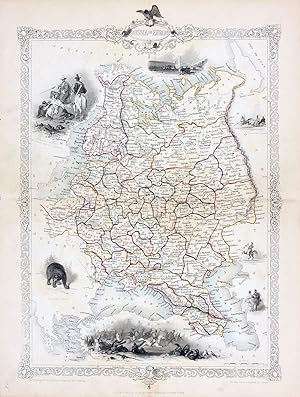
Russia in Europe, antique map with vignette views
Verlag: John Tallis & Co., London, 1854
Anbieter: Antipodean Books, Maps & Prints, ABAA, Garrison, NY, USA
Verbandsmitglied: ABAA ANZAAB ESA ILAB
Verkäuferbewertung 3 von 5 Sternen
Maps. Steel engraved map from the famous Victorian publisher John Tallis, well-known for the attractive vignette views surrounding the maps, which illustrate the peoples & customs of the region. 9 1/2 x 13 1/2" plus margins. Attractive decorative border around edge, period outline color, very good condition.
-
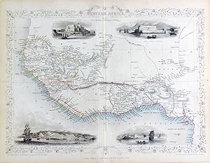
Western Africa, antique map with vignette views
Verlag: John Tallis & Co., London, 1854
Anbieter: Antipodean Books, Maps & Prints, ABAA, Garrison, NY, USA
Verbandsmitglied: ABAA ANZAAB ESA ILAB
Verkäuferbewertung 3 von 5 Sternen
Maps. Steel engraved map from the famous Victorian publisher John Tallis, well-known for the attractive vignette views surrounding the maps, which illustrate the peoples & customs of the region. 12 1/2 x 10" plus margins. Attractive decorative border around edge, period outline color, very good condition.
-

West India Islands - West Indies - c.1865 Antique Engraving
Verlag: London Printing, UK, 1865
Anbieter: Maynard & Bradley, Leicester, Vereinigtes Königreich
Verkäuferbewertung 5 von 5 Sternen
EUR 26,17
EUR 25,40 Versand
Versand von Vereinigtes Königreich nach USAAnzahl: 1 verfügbar
In den WarenkorbSoftcover. Zustand: Very Good. c.1865. A lightly used but well-presented map, with a few very faint spots of foxing but no major marks or wear. Some visible fold lines as originally presented, but neatly flattened to a good, presentable standard. Why on Amazon do most sellers not describe their actual book? Buy with confidence and support a genuine Independent Bricks & Mortar Real Bookshop. We are Maynard & Bradley CAMBO & PBFA(now lapsed) members here in Leicester City Centre. Size: 355 x 275 mm. 1. Item Type: Book. Quantity Available: 1. Shipped Weight: Under 500 grams. Category: Geography & Maps; Britain/UK; 19th century; Inventory No: 47469.
-

Regional Map of British Guyana - c.1865 Antique Engraving
Verlag: London Printing, UK, 1865
Anbieter: Maynard & Bradley, Leicester, Vereinigtes Königreich
Verkäuferbewertung 5 von 5 Sternen
EUR 26,17
EUR 25,40 Versand
Versand von Vereinigtes Königreich nach USAAnzahl: 1 verfügbar
In den WarenkorbSoftcover. Zustand: Very Good. c.1865. A lightly used but well-presented map, with a few very faint spots of foxing but no major marks or wear. Some visible fold lines as originally presented, but neatly flattened to a good, presentable standard. Why on Amazon do most sellers not describe their actual book? Buy with confidence and support a genuine Independent Bricks & Mortar Real Bookshop. We are Maynard & Bradley CAMBO & PBFA(now lapsed) members here in Leicester City Centre. Size: 355 x 275 mm. 1. Item Type: Book. Quantity Available: 1. Shipped Weight: Under 500 grams. Category: Geography & Maps; Britain/UK; 19th century; Inventory No: 47470.
-

Cape Colony, Dutch & British Territory - c.1865 Antique Engraving
Verlag: London Printing, UK, 1865
Anbieter: Maynard & Bradley, Leicester, Vereinigtes Königreich
Verkäuferbewertung 5 von 5 Sternen
EUR 26,17
EUR 25,40 Versand
Versand von Vereinigtes Königreich nach USAAnzahl: 1 verfügbar
In den WarenkorbSoftcover. Zustand: Very Good. c.1865. A lightly used but well-presented map, with a few very faint spots of foxing but no major marks or wear. Some visible fold lines as originally presented, and some repair with conservation tape at the lower left and upper right corners, but neatly flattened to a good, presentable standard. Why on Amazon do most sellers not describe their actual book? Buy with confidence and support a genuine Independent Bricks & Mortar Real Bookshop. We are Maynard & Bradley CAMBO & PBFA(now lapsed) members here in Leicester City Centre. Size: 335 x 270 mm. 1. Item Type: Book. Quantity Available: 1. Shipped Weight: Under 500 grams. Category: Geography & Maps; Britain/UK; 19th century; Inventory No: 47477.
-

Regional Map of Germany - c.1865 Antique Engraving
Verlag: London Printing, UK, 1865
Anbieter: Maynard & Bradley, Leicester, Vereinigtes Königreich
Verkäuferbewertung 5 von 5 Sternen
EUR 26,17
EUR 25,40 Versand
Versand von Vereinigtes Königreich nach USAAnzahl: 1 verfügbar
In den WarenkorbSoftcover. Zustand: Very Good. c.1865. A lightly used but well-presented map, with a few very faint spots of foxing but no major marks or wear. Some visible fold lines as originally presented, and some repair with conservation tape at the upper right corner, but neatly flattened to a good, presentable standard. Why on Amazon do most sellers not describe their actual book? Buy with confidence and support a genuine Independent Bricks & Mortar Real Bookshop. We are Maynard & Bradley CAMBO & PBFA(now lapsed) members here in Leicester City Centre. Size: 265 x 360 mm. 1. Item Type: Book. Quantity Available: 1. Shipped Weight: Under 500 grams. Category: Geography & Maps; Britain/UK; 19th century; Inventory No: 47476.
-
The Battle of the Alma - Showing the English, French , Russian and Turkish Forces - an Original Antique Engraved Map
Sprache: Englisch
Erscheinungsdatum: 1860
Anbieter: K Books Ltd ABA ILAB, York, YORKS, Vereinigtes Königreich
Verbandsmitglied: ABA ILAB PBFA
Verkäuferbewertung 5 von 5 Sternen
EUR 23,84
EUR 22,57 Versand
Versand von Vereinigtes Königreich nach USAAnzahl: 1 verfügbar
In den WarenkorbNo Binding. Zustand: Very Good. Engraved By J. Rapkin (illustrator). An original antique engraved map, printed circa 1860. Hand-colouring contemporary. Mounted and ready to frame. A fine opportunity to purchase an attractive and decorative map - The Battle of the Alma - Showing the English, French , Russian and Turkish Forces on the 19th and 20th September, 1854. Lovley decoratively engraved frame.
-
MODERN PALESTINE Steel engraved map
Sprache: Englisch
Verlag: John Tallis and Company, London, 1851
Anbieter: Don Kelly Books, London, Vereinigtes Königreich
Verkäuferbewertung 3 von 5 Sternen
EUR 47,68
EUR 15,83 Versand
Versand von Vereinigtes Königreich nach USAAnzahl: 1 verfügbar
In den WarenkorbNo Binding. Zustand: Very Good. Rapkin J (illustrator). Steel engraving of modern Palestine with original hand outline. Image measures 12.75" x 9.5". Includes historically and culturally relevant vignettes such as views of Jaffa and Nazareth, fauna and natives of Lebanon. John Tallis Jr. (1817-1876) was a London born bookseller who continued the prolific map publishing company started by his father. After a partnership with his brother, Tallis Jr. expanded the business to New York in 1849 as well as Boston, Cincinnati, Rochester, Philadelphia and Baltimore. He is remembered as one of the last decorative map makers, and this lovely map exemplifies his work. Less.
-
Northern Italy, antique map with vignette views
Verlag: John Tallis & Co., London, 1854
Anbieter: Antipodean Books, Maps & Prints, ABAA, Garrison, NY, USA
Verbandsmitglied: ABAA ANZAAB ESA ILAB
Verkäuferbewertung 3 von 5 Sternen
Maps. Map of Northern Italy ending in Naples and including Corsica. Steel engraved map from the famous Victorian publisher John Tallis, well-known for the attractive vignette views surrounding the maps, which illustrate the peoples & customs of that region. 10 x 13 1/2" plus margins. Attractive decorative border around edge, period outline color, very good condition.
-
Venezuela, New Granada, Equador, and The Guayanas, antique map with vignette views
Verlag: John Tallis & Co., London, 1854
Anbieter: Antipodean Books, Maps & Prints, ABAA, Garrison, NY, USA
Verbandsmitglied: ABAA ANZAAB ESA ILAB
Verkäuferbewertung 3 von 5 Sternen
Maps. Steel engraved map from the famous Victorian publisher John Tallis, well-known for the attractive vignette views surrounding the maps, which illustrate the peoples & customs of that region. 10 x 13 1/2" plus margins. Attractive decorative border around edge, period outline color, very good condition.
-
France, antique map with vignette views
Verlag: John Tallis & Co., London, 1854
Anbieter: Antipodean Books, Maps & Prints, ABAA, Garrison, NY, USA
Verbandsmitglied: ABAA ANZAAB ESA ILAB
Verkäuferbewertung 3 von 5 Sternen
Maps. Steel engraved map from the famous Victorian publisher John Tallis, well-known for the attractive vignette views surrounding the maps, which illustrate the peoples & customs of the region. 12 1/2 x 10" plus margins. Attractive decorative border around edge, period outline color, sml. split at bottom of fold, o/w very good condition.
-
France, antique map with vignette views
Verlag: John Tallis & Co., London, 1854
Anbieter: Antipodean Books, Maps & Prints, ABAA, Garrison, NY, USA
Verbandsmitglied: ABAA ANZAAB ESA ILAB
Verkäuferbewertung 3 von 5 Sternen
Maps. Steel engraved map from the famous Victorian publisher John Tallis, well-known for the attractive vignette views surrounding the maps, which illustrate the peoples & customs of the region. 12 1/2 x 10" plus margins. Attractive decorative border around edge, period outline color, dusty on vignettes, o/w good condition.
-

Cabool, the Punjab and Beloochistan, antique map with vignette views
Verlag: John Tallis & Co., London, 1854
Anbieter: Antipodean Books, Maps & Prints, ABAA, Garrison, NY, USA
Verbandsmitglied: ABAA ANZAAB ESA ILAB
Verkäuferbewertung 3 von 5 Sternen
Maps. Map of modern Afghanistan, Pakistan, and a portion of North-West India. Steel engraved map from the famous Victorian publisher John Tallis, well-known for the attractive vignette views surrounding the maps, which illustrate the peoples & customs of that region. 10 x 13 1/2" plus margins. Attractive decorative border around edge, period outline color, very good condition.
-
Chili and La Plata, antique map with vignette views
Verlag: John Tallis & Co., London, 1854
Anbieter: Antipodean Books, Maps & Prints, ABAA, Garrison, NY, USA
Verbandsmitglied: ABAA ANZAAB ESA ILAB
Verkäuferbewertung 3 von 5 Sternen
Maps. Map of Chile with vignettes of travelling post, the Gobernador, the Grand Square of Buenos Ayres, Water Seller of Buenos Ayres and Rattlesnake. Steel engraved map from the famous Victorian publisher John Tallis, well-known for the attractive vignette views surrounding the maps, which illustrate the peoples & customs of that region. 10 x 13 1/2" plus margins. Attractive decorative border around edge, period outline color, very good condition.
-
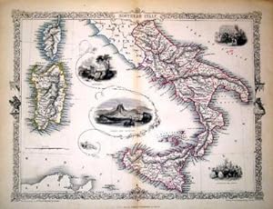
Southern Italy, antique map with vignette views
Verlag: John Tallis & Co., London, 1854
Anbieter: Antipodean Books, Maps & Prints, ABAA, Garrison, NY, USA
Verbandsmitglied: ABAA ANZAAB ESA ILAB
Verkäuferbewertung 3 von 5 Sternen
Maps. Map of Southern Italy from Rome down and including Corsica, Sardinia, and Sicily. Steel engraved map from the famous Victorian publisher John Tallis, well-known for the attractive vignette views surrounding the maps, which illustrate the peoples & customs of that region. 10 x 13 1/2" plus margins. Attractive decorative border around edge, period outline color, very good condition.
-
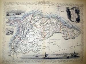
Venezuela, New Granada, Equador, and The Guayanas, antique map with vignette views
Verlag: John Tallis & Co., London, 1854
Anbieter: Antipodean Books, Maps & Prints, ABAA, Garrison, NY, USA
Verbandsmitglied: ABAA ANZAAB ESA ILAB
Verkäuferbewertung 3 von 5 Sternen
Maps. Steel engraved map from the famous Victorian publisher John Tallis, well-known for the attractive vignette views surrounding the maps, which illustrate the peoples & customs of that region. 10 x 13 1/2" plus margins. Attractive decorative border around edge, period outline color, very good condition.
-
The Premenstrual Syndromes: PMS and PMDD
Anbieter: Seagull Books, Hove, Vereinigtes Königreich
Verkäuferbewertung 5 von 5 Sternen
Erstausgabe
EUR 95,31
EUR 13,31 Versand
Versand von Vereinigtes Königreich nach USAAnzahl: 1 verfügbar
In den WarenkorbHardcover. Zustand: Very Good. 1st Edition. Has some light general reading/shelfwear - otherwise this is a clean, tight copy. Quick dispatch from the UK.
