
Gesamtpreis (1 Artikel Artikel):
Versandziel:

homann johann baptista (14 Ergebnisse)
Produktart
- Alle Product Types
- Bücher (5)
- Magazine & Zeitschriften
- Comics
- Noten
- Kunst, Grafik & Poster (1)
- Fotografien
- Karten (8)
- Manuskripte & Papierantiquitäten
Zustand
Einband
- alle Einbände
- Hardcover (1)
- Softcover
Weitere Eigenschaften
- Erstausgabe (1)
- Signiert
- Schutzumschlag
- Angebotsfoto (10)
Gratisversand
- Versand nach USA gratis
Land des Verkäufers
Verkäuferbewertung
-

Circuli Franconiae Pars Orientalis Et Potior novissime delineata; quam Illustrißimis Generaosißimis ac Exellentißimis Dn. Dn. Totio Circ. Francon. Legatis pro Salute publ. Norimbergae congragatis Dominis suis Gratiosis humillime D.D.D. Io. Bapt. Homann cum priv. Norimbergae (ca.1730). Flächenkolorierte Kupferstichkarte 48 x 55 cm. Blattgröße 52 x 60 cm. Die Karte zeigt Ober-, Mittel- und Unterfranken. Oben rechts nicht kolorierte Titelkartusche mit Putten und Wappen. Unten rechts Erklärungen und graphischer Maßstab (Milliaria Germanica communia, Milliaria Germanica magna). Unten links Erklärungen zur Koloration. Über der Karte Kopftitel in deutscher Sprache "Erster und größter Theil Des Ganzen Hochlöbl. Franckischen Craisses in welchem die Bisthumer Bamberg Wurtzburg und Aichstett, die Marggr. Culmbach und Onolzbach das Herzogt. Coburg, Fürstent. Schwartzenberg, Graffsch. Hohenloh, Castell Limburg und Seinsheim, das Nurembergische Gebiet und die Hälffte der angrenzenden Obern Pfalz mit
-
Zustand: Gut. 58 x 48 cm. *Mit kräftigem altem Grenz- und Flächenkolorit. - Sauber und gut erhalten. Sprache: Deutsch Gewicht in Gramm: 1200.
-
Regiae Celsitudinid Sabaudicae Status in quo Ducatus Sabaudiae Principatus Pedemontium et Ducatus Montisferrati in suas quasque Ditiones et Territoria divisi cum finitimis Regionibus exhibentur Directione et sumptibus. Norimbergae (ca. 1726). Flächenkolorierte Kupferstichkarte 57 x 50 cm. Die Karte zeigt Nordwest Italien. Oben rechts unkolorierte Titelkartusche mit Figurenstaffage. Unten rechts graphischer Maßstab (Milliaria Germanicae Communia. Milliaria Italica Communia). Die Karte ist etwas gebräunt und am Rand etwas fleckig. Die Ränder haben wenige Wurmspuren, das Kartenbild ist nicht betroffen. In der Mitte einmal gefaltet.
-
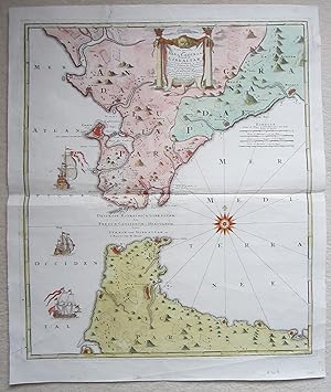
Carte nouvelle de L'Isle de Cadix & du Detroit de Gibraltar.
Verlag: Nurnberg, 1730
Anbieter: Angelika C. J. Friebe Ltd. - MapWoman, Dorking, Vereinigtes Königreich
Bewertung:

Karte
No Binding. Zustand: Very Good. copper engraved map with old hand colouring. overall 63 x 53 cm, plate 57 x 49 cm. fold as issued; additional printer's creases and soft creases; some marginal small tears; 2 repaired tears; o/w vg cond.- A beautifully decorated map of Gibraltar, the Straights of Gibraltar and Tangiers and Ceuta. Decorated with a windrose, a large cartouche, and 3 sailing ships.
-
Generalis Totius Imperii Russorum Novissima Tabula Magnam Orbis terrarum partem a Polo Arctico sife ad mare Japonicum et Chinae Septentrionalis confinia exhibens cum via Czaricae nuper Legationis ex urbe Moscua per universam Tartariam ad magnu Chinae Imperatorem ex conatibus Ioannis Baptistae Homannii. Norimbergiae (ca.1720). Flächenkolorierte Kupferstichkarte 56,5 x 49 cm. Blattgröße 59 x 51 cm. Unten links nicht kolorierte Titelkartusche mit Figurenstaffage und Putto. Oben rechts graphischer Maßstab (Milliaria Germanica Communia, Werst Sive Milliaria).- Mit Walfangszene im Polarmeer.- Die Karte ist etwas gebräunt und leicht fleckig, unten links leichte Knickfalte. Im unterern Drittel ist ist Mittelfalz ca. 8cm eingerissen. Mittelfalz und Ränder fachmännisch hinterlegt.
-
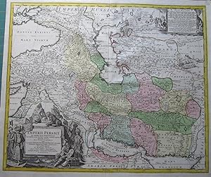
Imperii Persicii In Omnes Suas Provincias.
Erscheinungsdatum: 1720
Anbieter: Angelika C. J. Friebe Ltd. - MapWoman, Dorking, Vereinigtes Königreich
Bewertung:
Karte
No Binding. Zustand: Near Fine. Nuremberg c1720 orig. col. copper engr. map; 49 x 59 cm; nice strong impression, exc. cond. A map of the Persian Empire with a very large cartouche surrounded by Persian nobles and lion and tiger, and with one other vignette. This is the earlier issue without privilege. Homann was a self-taught engraver from Swabia, Germany, who worked for Funck, von Sandrat et al before he started his own business in 1702, publishing and compiling his own atlases. In 1715, he became geographer to the Holy Roman Emperor. After his death in 1724, he was succeeded by his son, Johann Christoph (1703 - 1730). [ref: 1665 ].
-
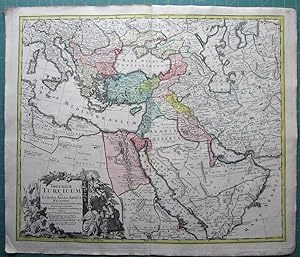
Imperium Turcicum in Europa, Asia et Africa regiones
Erscheinungsdatum: 1720
Anbieter: Angelika C. J. Friebe Ltd. - MapWoman, Dorking, Vereinigtes Königreich
Bewertung:
Karte
No Binding. Zustand: Very Good. for Atlas Novus Terrarum Orbis Imperia, Nuremberg, c1720+. copper engraved map with original colouring; plate size 52 x 60,5 cm. fold as issued; add. creases; evenly toned with some faint spots; indistinctive top plate mark/ cropped on top plate mark; top and lower c'fold tears rep. with rep. tape; o/w vg. cond. Detailed map of Arabia and the Turkish Empire with a large decorative cartouche. Homann was a German engraver and publisher who established himself and his family as perhaps the most famous German map publishers. Following his death in 1724, the business continued under the name "Homann Heirs".
-
Würzburg: Gesamtansicht aus halber Vogelschau. Titel: "Accurate Vorstellung der Hoch Fürstl. Bischöffl. Residenz und Haupt-Stadt Würtzburg". altkolorierter Kupferstich von Homann.
Verlag: Nürnberg, 1723
Kunst / Grafik / Poster
Zustand: Gut. Format (Bildbereich): 49 x 58 cm. Blattgröße 53 x 63 cm. *Oben mit Betitelung, unten mit Legende und einem Verzeichnis der Gebäude. - Leichter Querfalz, kleine hinterlegte Randeinrisse an den Falzen, sonst gut erhalten. - Unterrand mit einem alten Namensvermerk "Carl Roeder, Würzburg 1884" Sprache: Deutsch Gewicht in Gramm: 2000.
-
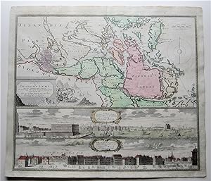
Accurate Carte der Upländischen Scheren.Stockholm.
Verlag: Nurnberg, 1730
Anbieter: Angelika C. J. Friebe Ltd. - MapWoman, Dorking, Vereinigtes Königreich
Bewertung:
Karte
No Binding. Zustand: Good. copper engraved map with old and some recent hand colouring; overall 53 x 61 cm, plate 50 x 58 cm. fold as issued and re-enforced; some minor marginal tears, some reapired; some additional soft creases; some discolouration and staining/ foxing; o/w g cond. A very attractive map of the area around Stockholm with two panoramic views of Stockholm by Homann.
-

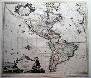
Totius Americae Septentrionalis et Meridionalis.
Verlag: Norimberge, 1740
Anbieter: Alexandre Antique Prints, Maps & Books, Toronto, ON, Kanada
Bewertung:

Karte
Zustand: Very Good. Decorative and detailed map of the Americas in original hand colouring. Johann Baptist Homann (20 March 1664 ? 1 July 1724) was a German geographer and cartographer, He founded his own publishing house in 1702. Homann died in Nuremberg in 1724. He was succeeded by his son Johann Christoph (1703?1730). The company carried on upon his death as Homann heirs company., Size : 485x588 (mm), 19.125x23.125 (Inches), Original Hand Coloring.
-
Totius Americae Septentrionalis et Meridionalis
Verlag: Nuremberg, Germany, 1716
Anbieter: Ken Sanders Rare Books, ABAA, Salt Lake City, UT, USA
Verbandsmitglied: ABAA ILAB IOBA RMABA
Bewertung:
Map. Zustand: Very good +. 57x48cm. Age toned. Hand painted. In a wooden frame covered with gold leaf. First map of America published by the Homann family. Heavily detailed, including a depiction of California as a large island.
-

Nova Anglia Septentrionali Americae implantata Anglorumque coloniis florentissima Geographica exhibita
Verlag: c. 1720, Nuremberg, 1720
Anbieter: Alexandre Antique Prints, Maps & Books, Toronto, ON, Kanada
Bewertung:
Karte
Zustand: Very Good. Size : 495x590 (mm), 19.5x23.25 (Inches), Original Hand Coloring.
-
Totius Americae Septentrionalis et Meridionalis.
Erscheinungsdatum: 1710
Anbieter: Angelika C. J. Friebe Ltd. - MapWoman, Dorking, Vereinigtes Königreich
Bewertung:
Karte
No Binding. Zustand: Very Good. Nurnberg 1710 copper engraved map with old hand colouring. overall 51,5 x 58,5 cm; plate 49,5 x 57,5 cm. fold as issued; paper evenly coloured; some discolouration, staining and faint foxing; small margins all around; some small worm holes in lower part of the map; o/w vg cond. A very beautifully engraved and unusual map of the American continent, showing California as an island by Homann. Original copied from the Sanson map, this is the first state of Homann iconic map; later states show the Californian pensinula. With a large, decorative cartouche, copied from de Fer's map of 1699, which shows indigenous people, traders and armadillos. The top left cartouche shows Old and New World Deities; with the branches which are later removed. Tooley (America) #79 [ref: 3254].
-
[CELESTIAL ATLAS] ATLAS NOVVS// COELESTIS // IN QVO // MVNDVS SPECTABILIS, // ET IN EODEM // TAM ERRANTIVM QVAM INERRANTIVM STELLARVM // PHOENOMENA NOTABILIA, // CIRCA IPSARVM LVMEN, FIGVRAM, FACIEM, MOTVM, ECLI-// PSES, OCCVLTATIONES TRANSITVS, MAGNITVDINES DISTAN-// TIAS, ALIAQVE // SECVNDVM // NIC. COPERNICI // ET EX PARTE // TYCHONIS DE BRAHE // HIPOTHESIN, // NOSTRI INTUITU, SPECIALITER, RESPECTU VERO AD AP-// PARENTIAS PLANETARVM INDAGATV POSSIBILES E PLANETIS PRI- //MARIIS, ET E LUNA HABITO, GENERALITER, // E CELEBERRIMORVM ASTRONOMORUM OBSERVATIONIBUS // GRAPHICE DE SCRIPA EXHIBENTVR // A // IOH. GABRIELE DOPPELMAIERO. // ACADEMIARVM IMPP. LEOPOLDINO-CAROLINAE ET PETRO- // POLITANE, SOCIETATVMQVE REGG. SCIENTIARVM BRITTANICAE ET // BORVSSICAE, SODALI, NEC NON PROFESSORE PVBL. MATHEMA- // TVM NORIMB. // NORIMBERGAE. // Sumptibus Heredum Homannianorum, A. 1742
Verlag: Heirs of Homann, c. 1742, Nuremberg/ Norimbergae:, 1742
Anbieter: Alexandre Antique Prints, Maps & Books, Toronto, ON, Kanada
Bewertung:
Erstausgabe
Edition : First Edition of Doppelmayr?s important astronomic, Contemporary full calf; panelled with outer double gilt filleted border and inner single fillet; expertly rebacked with five (5) raised bands, gilt lettered title on brown morocco label on two and gilt ornamental design in remaining compartments; dated at bottom; red-black marbled endpapers. , Text and captions in Latin. Johann Gabriel Doppelmayr (27 September 1677 ? 1 December 1750) was a German mathematician, astronomer, and cartographer. (His surname is also spelled Doppelmayer and Doppelmair.) His studies included mathematics, physics, and jurisprudence. In 1698 he graduated with a dissertation on the Sun. After giving up his legal studies he then spent two years travelling and studying in Germany, Holland, and England, spending time at Utrecht, Leiden, Oxford, and London. He continued to study astronomy and learned to grind and figure his own telescope lenses. The DSB describes this work as a collection of diagrams with its explanations intended as introduction into the fundamentals of astronomy, explaining the systems of Copernicus, Tycho Brahe, and Riccioli, the elliptic theories of Kepler, Boulliau, Seth Ward, and Mercator, as well as the lunar theories of Tycho Brahe, Horrocks and Newton, and Halley's cometary theory. The atlas shows constellations, cometary plates, lunar maps, lunar theories, charts of satellite systems, and the motion of planets with plates depicting celestial charts with diagrams, tables and views of observatories. , Size : Folio; (535x321mm)., Illustrated allegorical title by J. C. Reinsberger depicting Claud. Ptolemy, Nic. Copernicus, Ioh. Kepler and Tycho Brahe. preceding title in red and black with vignette of the heavens; extra illustrated with two additional double-page celestial maps entitled: 1. ?SPHAERARUM ARTIFICIALIUM TYPICA REPRAESENTATIO? and 2.?PLANISPHAERIUM CAELESTE?; with the complete set of thirty (30) astronomical and cosmographical double-page plates in colour as listed under Rodney Shirley C.DOP-1c, p.1336/7., upper pasted endpaper bookplate of William Phelps. , References : Shirley II, C.DOP-1c, 1136/7; DSB IV, 166; Brown: 51; Warner, Sky: 64a; Sotheran I: 1080; Poggendorff I: 593; LGK I: 177., Ff. [2f bl.], Illustrated half-title leaf, illustrated title leaf, 32 double-page engraved plates, [2f bl.]. Near fine copy of the famous celestial atlas of copper engravings in contemporary hand-colour and attractive, expertly restored contemporary binding; lacking the index sheet; two minor repaired tears at lower margins; fine plates depicting the solar system, planetary motions, constellations, a moon map; small views featuring famous observatories in Berlin, Kassel, Nuremberg and Danzig.


