
Gesamtpreis (1 Artikel Artikel):
Versandziel:

homann heirs (123 Ergebnisse)
Feedback
Direkt zu den wichtigsten Suchergebnissen
Suchfilter
Produktart
- Alle Product Types
- Bücher (29)
- Magazine & Zeitschriften (Keine weiteren Ergebnisse entsprechen dieser Verfeinerung)
- Comics (Keine weiteren Ergebnisse entsprechen dieser Verfeinerung)
- Noten (Keine weiteren Ergebnisse entsprechen dieser Verfeinerung)
- Kunst, Grafik & Poster (5)
- Fotografien (Keine weiteren Ergebnisse entsprechen dieser Verfeinerung)
- Karten (89)
- Manuskripte & Papierantiquitäten (Keine weiteren Ergebnisse entsprechen dieser Verfeinerung)
Zustand
- Alle
- Neu (Keine weiteren Ergebnisse entsprechen dieser Verfeinerung)
- Antiquarisch (123)
Einband
- alle Einbände
- Hardcover (1)
- Softcover (Keine weiteren Ergebnisse entsprechen dieser Verfeinerung)
Weitere Eigenschaften
- Erstausgabe (1)
- Signiert (Keine weiteren Ergebnisse entsprechen dieser Verfeinerung)
- Schutzumschlag (Keine weiteren Ergebnisse entsprechen dieser Verfeinerung)
- Angebotsfoto (109)
Sprache (1)
Gratisversand
- Kostenloser Versand nach Deutschland (Keine weiteren Ergebnisse entsprechen dieser Verfeinerung)
Land des Verkäufers
Verkäuferbewertung
-
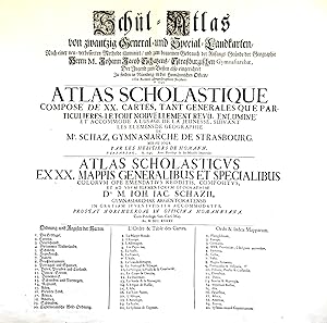
Schul-Atlas von zwantzig General- und Special-Landkarten, nach einer verbesserten Methode illuminirt, und zum bequemen Gebrauch der Anfangs-Gründe der Geographie . der Jugend zum Besten also eingerichtet / Atlas scholastique, composé de XX. cartes . / Atlas scholasticus ex XX. mappis .
Verlag: Nürnberg: Homännische Officin dat. ,, 1745
Anbieter: Antiquariat Ruthild Jäger, Lueneburg, Deutschland
Verkäuferbewertung 3 von 5 Sternen

EUR 80,00
Währung umrechnenEUR 5,00 für den Versand innerhalb von/der DeutschlandAnzahl: 1 verfügbar
In den Warenkorb(Gr.-Folio). 1 Blatt (mittig gefaltet), 56 x 51 cm. (minimale Randeinrisse sorgfältig unterlegt, sonst sehr gut erhalten; small tears in the margins repaired, otherwise in good condition). * Auf dem deutsch/französisch/lateinischen Titelblatt werden die zwanzig im Atlas enthaltenen Landkarten aufgeführt. Der Homann'sche Schul-Atlas war konzipiert als Ergänzung des Geographie-Lehrbuches für Schulen aus der Feder des Gymnasialdirektors Johann Jacob Schatz (1720 Rektor in Trarbach, 1728 Direktor und Bibliothekar Gymnasium Eisenach, 1737 Direktor Gymnasium Straßburg). (#9677AB).
-

Li Regni di Sicilia e Sardegna colle Adiacenti Isole di Corsica, Elba, Malta e Liparee, o di Vulcano,
Verlag: non men che parte delle spiagge settentrionali dell'Africa e delle Meridionali d'Italia…. Norimbergo, A spese degl'Eredi d'Homann MDCCLXII., Norimberga, 1762
Anbieter: Libreria Antiquaria Pregliasco, Torino, Italien
Verkäuferbewertung 4 von 5 Sternen

EUR 800,00
Währung umrechnenEUR 25,00 für den Versand von Italien nach DeutschlandAnzahl: 1 verfügbar
In den WarenkorbZustand: molto buono. Incisione originale in rame(mm 380x580 e margini) arricchita da bella colorazione coeva. Bellissima carta che comprende territori dell'Italia meridionale, Sicilia, Sardegna, Corsica, Malta, Nord Africa. Titolo su quattro righe lungo il margine superiore del rame. Nel quadrante inferiore sinistro č presente un elaborato cartiglio con titolo, un veliero gli stemmi araldici di Sicilia, Sardegna e Malta, un guerriero, forse Persus, con lo scudo di Medusa. In basso al centro la scala miliare. Disegnata da G. A. b. Rizzi Zannoni N. Padovano, tratta dall'atlante edito dagli eredi di Homann "Maior Atlas Scholasticus ex Triginta Sex Generalibus et Specialibu"s. del 1752. Bell'esemplare con qualche piccola macchietta nel margine bianco.Gli Eredi Homann (1730 - 1848) casa editrice di carte geografiche con sede a Norimberga, attivi dalla metŕ alla fine del XVIII secolo. Dopo la morte del grande cartografo Johann Baptist Homann (1664 - 1724), la direzione dell'azienda passň al figlio Johann Christoph Homann (1703 - 1730). J. C. Homann, forse rendendosi conto che non sarebbe sopravvissuto a lungo al padre, stabilě nel suo testamento che l'azienda sarebbe stata ereditata dai suoi due direttori, Johann Georg Ebersberger (1695 - 1760) e Johann Michael Franz (1700 - 1761), e che sarebbe stata pubblicata solo con il nome di "Eredi Homann". Questa denominazione, compare sulle mappe a partire dal 1731 circa. L'azienda continuň a pubblicare mappe in quantitŕ sempre minore fino alla morte dell'ultimo proprietario, Christoph Franz Fembo (1781 - 1848). La Gumina n. 428. Book.
-
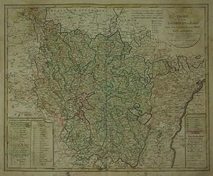
Charte von Lothringen und Barr Nebst den drey Bisthümern Metz, Toul und Verdun. Nach den besten französischen Charten entmorsen und verbessert von F.L. Güssefeld.
Verlag: Nuremberg:, 1793
Anbieter: Robert Frew Ltd. ABA ILAB, London, Vereinigtes Königreich
Verbandsmitglied: ABA ILAB PBFA
Verkäuferbewertung 4 von 5 Sternen
Karte
EUR 91,44
Währung umrechnenEUR 7,69 für den Versand von Vereinigtes Königreich nach DeutschlandAnzahl: 1 verfügbar
In den Warenkorb46.5 x 57.4 cm. Double page copper engraved map of Lorraine. Original colour in block and outline. Old brief title inscriptions in ink to verso of map. Staining and offsetting across sheet.
-
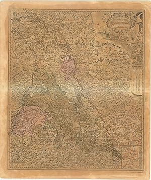
Ducatus Iuliaci & Bergensis Tabula Geographia, simul Ducatum Cliviae & Meursiae .
Verlag: Nurembergc., 1750
Anbieter: Robert Frew Ltd. ABA ILAB, London, Vereinigtes Königreich
Verbandsmitglied: ABA ILAB PBFA
Verkäuferbewertung 4 von 5 Sternen
Karte
EUR 121,92
Währung umrechnenEUR 7,69 für den Versand von Vereinigtes Königreich nach DeutschlandAnzahl: 1 verfügbar
In den Warenkorb57 x 48.2 cm. Original colour in block and outline. Double page map showing the duchies of Julich, Berg and Cleves. Paper browned unevenly.
-
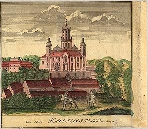
Das Schloß Fürstenstein von Morgen Scenographia Urbium Silesiae, tab. VI, 1738, Homann Heirs. Das ist VORSTELLUNG der Prospecte von den Staedten SCHLESIENS. sechste Tabell. in welcher die Fürnehmsten Staedte des Fürst. SCHWEIDNITZ accurat vorgestellet werden, entworfen von F.B.Werner Siles. und angefertigt von den Homaennischen Erben. Nürnberg 1738. Cum pr. S.C.M.
Verlag: Fr. B. Werner, Nürnberg, 1738
Anbieter: Antiquariat Reinhold Berg eK Inh. R.Berg, Regensburg, Deutschland
Verkäuferbewertung 5 von 5 Sternen

Karte
EUR 125,00
Währung umrechnenEUR 10,00 für den Versand innerhalb von/der DeutschlandAnzahl: 1 verfügbar
In den WarenkorbOther. Original antique copper engraving, hand colored in outline and wash, when published. Depict one view (from nine) of the,Scenographia Urbium Silesiae, tab. VI' published 1738 by Homann Heirs, engraved from F.B. Werner. Cut close to engraved borderline of the map. Upper left side with a small mended tear in the margin, else in good condition. 150 by 150mm (6 by 6 inches). 150 by 150mm (6 by 6 inches).
-

'CARTE DE LA SOUVERAINETÉ DE NEUFCHATEL ET VALANGIN.'. Detailed map of the close area to the northwest of Lake Neuchatel in Switzerland, reaching to La-Chaux-de-Fonds and Morteau.
Verlag: Homann Heirs 1778, 1778
Anbieter: Garwood & Voigt, Sevenoaks, Vereinigtes Königreich
Verkäuferbewertung 5 von 5 Sternen
Karte
EUR 121,92
Währung umrechnenEUR 26,04 für den Versand von Vereinigtes Königreich nach DeutschlandAnzahl: 1 verfügbar
In den WarenkorbZustand: Fine. 41x58cm. Full original colour. Excellent condition.
-
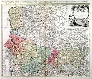
'CARTE DU GOUVERNEMENT GENERAL DE PICARDIE QUI COMPREND LA GENERALITÉ D'AMIENS AVEC L'ARTOIS & LES FRONTIERES DES PAYS BAS'.Map of northeast France between Paris and Dieppe / Calais, reaching east to the Belgian border. After Guillaume De L'Isle published by
Verlag: Homann Heirs 1746, 1746
Anbieter: Garwood & Voigt, Sevenoaks, Vereinigtes Königreich
Verkäuferbewertung 5 von 5 Sternen
Karte
EUR 121,92
Währung umrechnenEUR 26,04 für den Versand von Vereinigtes Königreich nach DeutschlandAnzahl: 1 verfügbar
In den WarenkorbZustand: Fine. 47x56cm. Full original colour. Excellent condition.
-
'CARTE VON UTRECHT'. Detailed map of the area 25 km around Utrecht, reaching to Bunschoten, Wageningen, Schoonhoven and Amsterdam. Published by Homann Heirs after
Verlag: Franz Ludwig Güssefeld 1787, 1787
Anbieter: Garwood & Voigt, Sevenoaks, Vereinigtes Königreich
Verkäuferbewertung 5 von 5 Sternen
Karte
EUR 121,92
Währung umrechnenEUR 26,04 für den Versand von Vereinigtes Königreich nach DeutschlandAnzahl: 1 verfügbar
In den WarenkorbZustand: Fine. 42x57cm. The map in full original colour. Excellent condition.
-
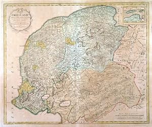
'CHARTE VON FRIESLAND'. Map of Friesland, Groningen and Drenthe, provinces in northern Holland. Published by Homann Heirs after
Verlag: Franz Ludwig Güssefeld 1786, 1786
Anbieter: Garwood & Voigt, Sevenoaks, Vereinigtes Königreich
Verkäuferbewertung 5 von 5 Sternen
Karte
EUR 121,92
Währung umrechnenEUR 26,04 für den Versand von Vereinigtes Königreich nach DeutschlandAnzahl: 1 verfügbar
In den WarenkorbZustand: Fine. 47x57cm. The map in full original colour. Overall agetoning, otherwise good condition.
-
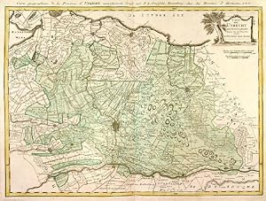
'CHARTE VON GELDERLAND UND DER DAZUGEHÖRIGEN GRAFSCHAFT ZUTPHEN'. Map of Gelderland and Zutphen, provinces in eastern Holland, reaching from Kampen to Enschede, Emmerich, Bommel and Utrecht. Published by Homann Heirs after
Verlag: Franz Ludwig Güssefeld 1787, 1787
Anbieter: Garwood & Voigt, Sevenoaks, Vereinigtes Königreich
Verkäuferbewertung 5 von 5 Sternen
Karte
EUR 121,92
Währung umrechnenEUR 26,04 für den Versand von Vereinigtes Königreich nach DeutschlandAnzahl: 1 verfügbar
In den WarenkorbZustand: Fine. 45x58cm. The map in full original colour. Overall agetoning, otherwise good condition.
-
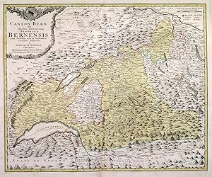
'CANTON BERN SIVE ILLUSTRIS HELVETIORUM RESPUBLICA BERNENSIS.'. Map of Kanton Bern and adjacent cantons in western Switzerland between Basel, Zürich, Rhone, Lac Leman / Genfer See and Lac de Neuchatel. Large cartouche with coat of arms. After Gabriel Walser published by
Verlag: Homann Heirs 1766, 1766
Anbieter: Garwood & Voigt, Sevenoaks, Vereinigtes Königreich
Verkäuferbewertung 5 von 5 Sternen
Karte
EUR 121,92
Währung umrechnenEUR 26,04 für den Versand von Vereinigtes Königreich nach DeutschlandAnzahl: 1 verfügbar
In den WarenkorbZustand: Fine. 47x57cm. The map in full original colour. Excellent condition.
-
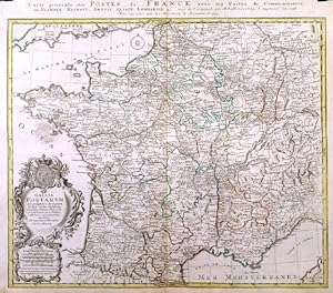
'GALLIA POSTARUM GEOGRAPHICE DESIGNATA. / CARTE GENERALE DES POSTES DE LA FRANCE'. A general post map of France showing the connections and communications. After Hubert Jaillot published in Nürnberg by
Verlag: Homann Heirs 1745, 1745
Anbieter: Garwood & Voigt, Sevenoaks, Vereinigtes Königreich
Verkäuferbewertung 5 von 5 Sternen
Karte
EUR 121,92
Währung umrechnenEUR 26,04 für den Versand von Vereinigtes Königreich nach DeutschlandAnzahl: 1 verfügbar
In den WarenkorbZustand: Fine. 48 x 56 cm. Original outline colour. Excellent condition.
-
Carte D' Artois et des Environs Vel Mappa Specalis Comitatus Artesiae in qua simul Terrae Iurisdictionales.de l'Isle designata. Recudentibus Homannianis Heredib.
Verlag: Homann Heirs 1740-50, Nürnberg, 1740
Anbieter: Antiquariat Reinhold Berg eK Inh. R.Berg, Regensburg, Deutschland
Verkäuferbewertung 5 von 5 Sternen
Karte
EUR 145,00
Währung umrechnenEUR 10,00 für den Versand innerhalb von/der DeutschlandAnzahl: 1 verfügbar
In den WarenkorbOther. Original antique copper engraving, hand colored and wash when published. Ornated in the upper right corner with a large allegoric title cartouche, as well a small mileage scale in the upper left corner. Fine detailed engraved map showing the duchy of Artois with its surroundings. With many place names and details like streets, woods, mountains, rivers, lakes etc. Still in very good condition, a minor gluestaining at the centre-fold. 482 by 570mm (19 by 22 inches).
-
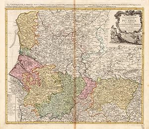
Carte du Govvernement General de Picardie qui comprend La Generalite D' Amiens avec L' Artois & les Frontieres des Pays Bas.
Verlag: Homann Heirs, Nürnberg, 1746
Anbieter: Antiquariat Reinhold Berg eK Inh. R.Berg, Regensburg, Deutschland
Verkäuferbewertung 5 von 5 Sternen
Karte
EUR 155,00
Währung umrechnenEUR 10,00 für den Versand innerhalb von/der DeutschlandAnzahl: 1 verfügbar
In den WarenkorbOther. Original antique copper engraving, hand colored and wash when published. Ornated in the upper right corner with a large allegoric title cartouche, as well a small table of explanations in the lower left corner. Fine detailed engraved map showing the government of the Picardie, including Amiens, Artois and the borders to Belgium. With many place names and details like streets, woods, mountains, rivers, lakes etc. In very good condition, slightly visable gluestaining at the centre-fold. 480 by 552mm (19 by 21 inches). 480 by 552mm (19 by 21 inches).
-
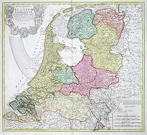
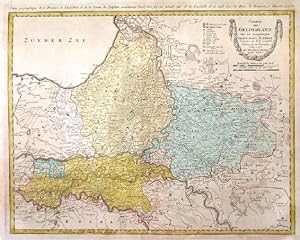
Septem Provinciae seu Belgium Foederatum quod generaliter Hollandia audit
Verlag: Homann Heirs, Nuremberg, 1748
Anbieter: Antikvariat Krenek, Prag, Tschechien
Verbandsmitglied: ILAB
Verkäuferbewertung 5 von 5 Sternen
Karte
EUR 159,00
Währung umrechnenEUR 12,50 für den Versand von Tschechien nach DeutschlandAnzahl: 1 verfügbar
In den WarenkorbKein Einband. Zustand: Gut bis sehr gut. The Netherlands. "Septem Provinciae seu Belgium Foederatum quod generaliter Hollandia audit". Orig. copperplate engraving published by Homann's Heirs, 1748 after T. Maier's map. Original old colouring. With great heraldic title cartouche (with 7 coats-of-arms). 47:51,5 cm (18 1/2 x 20 1/4 inch.). Detailed map of the Low Countries, with 7 coats of arms of Geldern, Holland, Zeeland, Utrecht, Friesland, Ober Issel and Groningen.
-
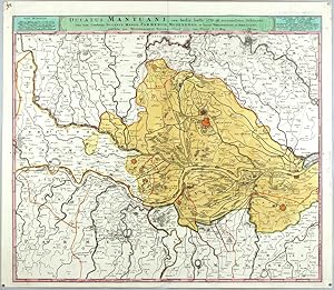
Ducatus Mantuani, ceu Sedis belli 1733-35 recentissima Delineatio
Verlag: Homann Heirs, Nuremberg, 1735
Anbieter: Antikvariat Krenek, Prag, Tschechien
Verbandsmitglied: ILAB
Verkäuferbewertung 5 von 5 Sternen
Karte
EUR 187,52
Währung umrechnenEUR 12,50 für den Versand von Tschechien nach DeutschlandAnzahl: 1 verfügbar
In den WarenkorbKein Einband. Zustand: Sehr gut. Mantua. "Ducatus Mantuani, ceu Sedis belli 1733-35 recentissima Delineatio, una cum Ducatus Mediol. Parmensis, Modenensis, et Territ. Veronensis et Bresciani". Orig. copperplate engraving, Homann's Heirs, 1735. With title bar above the map. 49,5:57,5 cm (19 1/2 x 22 3/4 inch.). Map of the province of Mantova in Lombardy. With red coloured fortified towns of Mantova, Mirandola, Guidizollo and others. - Beautiful impression with rich colours.
-
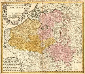
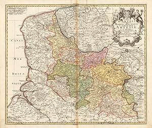
Belgium Catholicum seu Decem Provinciae Germaniae Inferioris cum consiniis Germaniae Sup. et Franciae Legitime omnia delineata et ad duetum observationum astronomicarum, nen non Geometriacarum operationum a Cassinio Snellio Muschenbrokio aliisquerite habitarum examinata studiosissime et representata a Tob. Maiero. Math. Cult. Edentibus Homannianis Heredib. A. 1747 Carte des Pais Bas Catholiques ou des X Provinces de l'Allemagne Inserieure etc dessinée au juste selon les exactes observations Astronomiques et Operations Geometriques des Messur. Cassini. Snellius. Muschenbrok etc. dressee par Sr. Tobias Maier Mathematicien. Aux depens des Heritiers de Homann. 1 An 1747. Avec Privil Imperial
Verlag: Nürnberg, 1747
Anbieter: Antiquariat Reinhold Berg eK Inh. R.Berg, Regensburg, Deutschland
Verkäuferbewertung 5 von 5 Sternen
Karte
EUR 190,00
Währung umrechnenEUR 10,00 für den Versand innerhalb von/der DeutschlandAnzahl: 1 verfügbar
In den WarenkorbOther. Original antique copper engraving, hand colored in outline and wash when published. This antique map shows Belgium with its neighboring counties Luxembourg and Holland. The map is equipped with many place names, rivers, woods, lakes, etc. Around the title, which is in the upper left corner, are many coat of arms. In the lower left corner we see an allegoric cartouche, which has the mileage scale inside. The explanation from the map is in the lower right corner. In good condition. Cut close to the descriptive text at the top of the map. A small mending at the bottom of the centre fold, a few minor spots, mostly only visible verso. 474 by 556mm (18 by 22 inches). 474 by 556mm (18 by 22 inches).
-
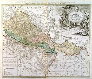
'TABULA GEOGRAPHICA EXHIBENS REGNUM SCLAVONIAE CUM SYRMII DUCATU.'. Map of the eastern part of Croatia between the rivers Drava and Sava, reaching from Belgrad (Serbia) to Vellika and Virovitica (Croatia), with large figurative cartouche and table of explanations
Verlag: Homann Heirs 1745, 1745
Anbieter: Garwood & Voigt, Sevenoaks, Vereinigtes Königreich
Verkäuferbewertung 5 von 5 Sternen
Karte
EUR 182,87
Währung umrechnenEUR 26,04 für den Versand von Vereinigtes Königreich nach DeutschlandAnzahl: 1 verfügbar
In den WarenkorbZustand: Fine. 46x56cm. The map in full original colour. Occasional slightly browned white margins. Excellent condition.
-
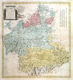
CASTILIAE NOVAE PARS OCCIDENTALIS PROVINCIAS MADRIT, TOLEDO ET MANCHA . Map of the central Spanish povinces of Madrid, Toledo and La Mancha with pictorial cartouche and scale of miles. Toledo is the capital of Castilla-La Mancha and it is also the imperial city. La Mancha is one of the emerging wine regions in Spain starting to produce high quality wines. White grape Airén is the most commonly grown white grape in the world, and Castile-La Mancha can be considered as its homeland. Other white grapes grown in Castile-La Mancha are Torrontés, Merseguera, Malvar, Viognier and Macabeo, among others. Regarding red grapes, red wines from this Spanish region are made with Cencíbel (Tempranillo), Cabernet Sauvignon, Merlot, Garnacha, Monastrell, P
Verlag: Homann Heirs 1781, 1781
Anbieter: Garwood & Voigt, Sevenoaks, Vereinigtes Königreich
Verkäuferbewertung 5 von 5 Sternen
Karte
EUR 182,87
Währung umrechnenEUR 26,04 für den Versand von Vereinigtes Königreich nach DeutschlandAnzahl: 1 verfügbar
In den WarenkorbNo Binding. Zustand: Fine. 50x45cm. The map in full original colour. Excellent condition. Small insignificant brown spot, otherwise fine.
-
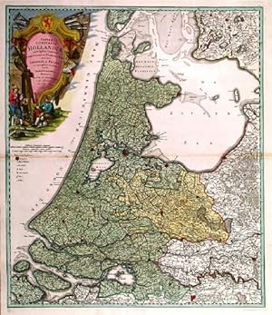
'TABULA COMITATUS HOLLANDIAE.'. Map of Holland, the northwest province of The Netherlands between North Sea, Zuyder Sea and the Waal, with Amsterdam in the centre. Large pictorial cartouche.
Verlag: Homann Heirs 1733, 1733
Anbieter: Garwood & Voigt, Sevenoaks, Vereinigtes Königreich
Verkäuferbewertung 5 von 5 Sternen
Karte
EUR 213,35
Währung umrechnenEUR 26,04 für den Versand von Vereinigtes Königreich nach DeutschlandAnzahl: 1 verfügbar
In den WarenkorbZustand: Fine. 57x49cm. Full original colour, incl. cartouche. Fold slightly agetoned, otherwise very good condition.
-
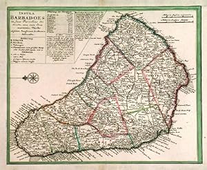
'INSULA BARBADOES IN SUAS PAROCHIAS DISTINCTA.'. Detailed map of Barbados, north orientated to the left.
Verlag: Homann Heirs ca. 1740, 1740
Anbieter: Garwood & Voigt, Sevenoaks, Vereinigtes Königreich
Verkäuferbewertung 5 von 5 Sternen
Karte
EUR 243,83
Währung umrechnenEUR 26,04 für den Versand von Vereinigtes Königreich nach DeutschlandAnzahl: 1 verfügbar
In den WarenkorbZustand: Fine. 22x28cm. Original outline colour. Excellent condition. Margins extended.
-

Imperii Turcici Europaei Terra, in primis Graecia cum confiniis
Verlag: Homann Heirs, Nuremberg, 1741
Anbieter: Antikvariat Krenek, Prag, Tschechien
Verbandsmitglied: ILAB
Verkäuferbewertung 5 von 5 Sternen
Karte
EUR 259,00
Währung umrechnenEUR 12,50 für den Versand von Tschechien nach DeutschlandAnzahl: 1 verfügbar
In den WarenkorbKein Einband. Zustand: Gut bis sehr gut. Greece, Mediterranean. "Imperii Turcici Europaei Terra, in primis Graecia cum confiniis". Orig. copperplate engraving after J. Ch. Harenberg map of the region. Published by Homann Heirs, 1767. Orig. old colouring. With ornamental and heraldic title-cartouche and explanatory notes above the picture. 51:57 cm (20 x 22 1/2 inch.). A map of Greece and the eastern Mediterranean with Corsica, Italy, Cyprus, and Crete, and the borders of Libya and Egypt.
-

Insula Iamaica in suas Parochias divisa, et secundum Exemplar primitivum Londinense excusa.
Verlag: Nuremberg, 1740
Anbieter: Alexandre Antique Prints, Maps & Books, Toronto, ON, Kanada
Verkäuferbewertung 2 von 5 Sternen

Karte
EUR 269,78
Währung umrechnenEUR 7,42 für den Versand von Kanada nach DeutschlandAnzahl: 1 verfügbar
In den WarenkorbZustand: Very Good, margins extended. Size : 144x267 (mm), 5.625x10.5 (Inches), Original Outline Coloring.
-

Carte nouvelle de L'Isle de Cadix & du Detroit de Gibraltar
Verlag: Homann Heirs, Nuremberg, 1756
Anbieter: Antikvariat Krenek, Prag, Tschechien
Verbandsmitglied: ILAB
Verkäuferbewertung 5 von 5 Sternen
Karte
EUR 270,86
Währung umrechnenEUR 12,50 für den Versand von Tschechien nach DeutschlandAnzahl: 1 verfügbar
In den WarenkorbKein Einband. Zustand: Sehr gut. Gibraltar, Cádiz, Ceuta. "Carte nouvelle de L'Isle de Cadix & du Detroit de Gibraltar". Orig. copperplate engraving by R. A. Schneider after J. de Petit's map. Issued by J. F. Weidler. Published by Homann's Heirs, 1756. Orig. old colouring. With ornamental title-cartouche, a wind-rose and 3 ships. 57:48,5 cm (22 1/2 x 19 1/4 inch.). A decorative map of Gibraltar Strait with Cadiz, Malaga, Ceuta, Tanger and some other cities of the region. - Nice, dark impression.
-

Il Lazio, con Strade Antiche e Moderne
Verlag: Nürnberg, 1745
Anbieter: Antikvariat Krenek, Prag, Tschechien
Verbandsmitglied: ILAB
Verkäuferbewertung 5 von 5 Sternen
EUR 270,86
Währung umrechnenEUR 12,50 für den Versand von Tschechien nach DeutschlandAnzahl: 1 verfügbar
In den Warenkorb"Il Lazio, con . Strade Antiche e Moderne . Latium cum . viis . Antiqvum & novum Statum". Orig. copperplate engraving. Published in Nuremberg by Homann Heirs, 1745. Orig. old colouring. With It.-Lat. title-cartouche and a cartouche with the scale of map and explanatory notes. 50,5:59 cm (19 3/4 x 23 1/4 inch.). A map of Lazio with the city of Rome on the left. Oriented to the east.
-

Canton Freiburg
Verlag: Homann Heirs, Nuremberg, 1767
Anbieter: Antikvariat Krenek, Prag, Tschechien
Verbandsmitglied: ILAB
Verkäuferbewertung 5 von 5 Sternen
Karte
EUR 271,00
Währung umrechnenEUR 12,50 für den Versand von Tschechien nach DeutschlandAnzahl: 1 verfügbar
In den WarenkorbKein Einband. Zustand: Sehr gut. Canton of Fribourg. "Canton Freiburg sive pagus Helvetiae Friburgensis". Orig. copperplate engraving after G. Walser's map of the region. Published by Homann Heirs in Nuremberg, 1767. Original old colouring. With ornamental title-cartouche and another ornamental cartouche in lower right corner. 47:57 cm (18 1/2 x 22 1/2 inch.). A map of the Canton Freiburg (aslo Freiburg) in western Switzerland.
-

Oberpfalz Nordgau Delineatio Nordgoviae Veteris prout ejus facies Seculo XI. & XII. suit, Geographice designata per Iohannem Henricum de Falckenstein C.A.B.O. ac in lucem emisa sumtibus Homannianorum Heredum Norib. 1733
Verlag: Homann Heirs, Nürnberg, 1733
Anbieter: Antiquariat Reinhold Berg eK Inh. R.Berg, Regensburg, Deutschland
Verkäuferbewertung 5 von 5 Sternen
Karte
EUR 275,00
Währung umrechnenEUR 10,00 für den Versand innerhalb von/der DeutschlandAnzahl: 1 verfügbar
In den WarenkorbOther. Original antique copper engraving in full contemporary hand color in wash and outline when published. Im rechten Bildrand mittig floral eingefasste Titelkartusche, sowie rechts oben Insetkarte mit der Fossa Carolina bei Dietfurt a.d. Altmühl. Historische Karte des Nordgaus nach der Zeichnung von Johann Heinrich v. Falckenstein. Published plano without a centre fold. In excellent condition. 455 by 554mm (18 by 21 inches). 455 by 554mm (18 by 21 inches).
-

Chorographia Territorii Naumburgocitiensis Episcopatuus olim nomine celebris una cum magna Consiniorum parte exactissime designata a Ioh: Georg: Schreibero Edita curis et impensis Homannianorum Heredum Norib: A. MDCCXXXII Cum Privilegio Sac. Caes. Maj.
Verlag: Homann 1732-40, Nürnberg, 1732
Anbieter: Antiquariat Reinhold Berg eK Inh. R.Berg, Regensburg, Deutschland
Verkäuferbewertung 5 von 5 Sternen
Karte
EUR 275,00
Währung umrechnenEUR 10,00 für den Versand innerhalb von/der DeutschlandAnzahl: 1 verfügbar
In den WarenkorbOther. Original antique copper engraving, hand colored in outline and wash. Engraved after a sketch by J. G. Schreiber published at Homanns Heirs in Nürnberg. Das Kartenbild zeigt den Bereich von Borna im Osten bis Camburg im Westen, im Norden von Freiburg bis Gerau im Süden. In der linken unteren Ecke ist eine große allegorische Titelkartusche graviert. Eine Erklärung der Zeichen über die Größe der Städte und Dörfer, Straßen und Brücken ist in der oberen rechten Ecke angebracht.The map shows the area from Borna in the east to Camburg in the west, in the north from Freiburg to Gerau in the south. A large allegorical title cartouche is engraved in the lower left corner. An explanation of the signs about the size of towns and villages, streets and bridges is in the upper right corner. In excellent condition. Published plano without a centre fold. 456 by 550mm (18 by 21 inches). 456 by 550mm (18 by 21 inches).
-

Status Mutinensis in suas ditiones utpote Ducatum Mutinensem, Reginensem. Mirandulanum, Princiratum Carpiensem et
Verlag: Homann Heirs, Nuremberg, 1740
Anbieter: Antikvariat Krenek, Prag, Tschechien
Verbandsmitglied: ILAB
Verkäuferbewertung 5 von 5 Sternen
Karte
EUR 283,36
Währung umrechnenEUR 12,50 für den Versand von Tschechien nach DeutschlandAnzahl: 1 verfügbar
In den WarenkorbKein Einband. Zustand: Sehr gut. Modena. "Status Mutinensis in suas ditiones utpote Ducatum Mutinensem, Reginensem. Mirandulanum, Princiratum Carpiensem et Corregiensem exacte divis, nec non finitimarum Regionum novissima Tabula". Orig. copperplate engraving, Homann's Heirs, Nuremberg, ca. 1740. Original old colouring. With Italian title above the map ("Tavola dello Stato di Modena ."), ornamental title-cartouche and the scale of map. 48:50 cm (19 x 19 3/4 inch.). A map of the province of Modena in the Emilia-Romagna region. With the fortified towns of Modena, Reggio Emilia, Carpi, Corregio, Mirandola and Berscello coloured red.
-

Oran
Verlag: Nuremberg. 1732, 1732
Anbieter: Peter Harrington. ABA/ ILAB., London, Vereinigtes Königreich
Verbandsmitglied: ABA ILAB PBFA
Verkäuferbewertung 5 von 5 Sternen
EUR 292,60
Währung umrechnenEUR 11,84 für den Versand von Vereinigtes Königreich nach DeutschlandAnzahl: 1 verfügbar
In den WarenkorbOran is in present day Algeria. The upper half is a map of the Oran, the lower half is a 'View of the Coast of Oran'. Text at the top in Latin and German, with a legend at the bottom. Seutter issued a very similar plan of Oran, as shown in Potter's Collecting Antique maps, p69 Potter: Collecting Antique maps Copper engraving. Very good condition, good margins, closed tear at lower edge near centrefold, expertly repaired, some darkening along centrefold Original colour. Size: 53 x 46 cm. (21 x 18 inches).