
Gesamtpreis (1 Artikel Artikel):
Versandziel:

Direkt zu den wichtigsten Suchergebnissen
Suchfilter
Produktart
- Alle Product Types
- Bücher (18)
- Magazine & Zeitschriften (Keine weiteren Ergebnisse entsprechen dieser Verfeinerung)
- Comics (Keine weiteren Ergebnisse entsprechen dieser Verfeinerung)
- Noten (Keine weiteren Ergebnisse entsprechen dieser Verfeinerung)
- Kunst, Grafik & Poster (Keine weiteren Ergebnisse entsprechen dieser Verfeinerung)
- Fotografien (Keine weiteren Ergebnisse entsprechen dieser Verfeinerung)
- Karten (3)
- Manuskripte & Papierantiquitäten (Keine weiteren Ergebnisse entsprechen dieser Verfeinerung)
Zustand Mehr dazu
- Neu (8)
- Wie Neu, Sehr Gut oder Gut Bis Sehr Gut (Keine weiteren Ergebnisse entsprechen dieser Verfeinerung)
- Gut oder Befriedigend (6)
- Ausreichend oder Schlecht (Keine weiteren Ergebnisse entsprechen dieser Verfeinerung)
- Wie beschrieben (7)
Einband
Weitere Eigenschaften
- Erstausgabe (2)
- Signiert (Keine weiteren Ergebnisse entsprechen dieser Verfeinerung)
- Schutzumschlag (Keine weiteren Ergebnisse entsprechen dieser Verfeinerung)
- Angebotsfoto (10)
Sprache (2)
Gratisversand
Land des Verkäufers
Verkäuferbewertung
-

Merry Christwitch
Anbieter: Better World Books, Mishawaka, IN, USA
Verkäuferbewertung 5 von 5 Sternen

Zustand: Very Good. Pages intact with possible writing/highlighting. Binding strong with minor wear. Dust jackets/supplements may not be included. Stock photo provided. Product includes identifying sticker. Better World Books: Buy Books. Do Good.
-

Soft cover. Zustand: Very Good. inscribed/signed by the author, Binding is solid, not even creased, light shelf rub on covers, text is free of markings, we ship quickly with tracking.
-

The Hell's Kitchen Cookbook: Recipes from the Kitchen
Sprache: Englisch
Verlag: Grand Central Life & Style, 2015
ISBN 10: 1455535699 ISBN 13: 9781455535699
Anbieter: WorldofBooks, Goring-By-Sea, WS, Vereinigtes Königreich
Verkäuferbewertung 5 von 5 Sternen
EUR 22,20
EUR 6,48 Versand
Versand von Vereinigtes Königreich nach USAAnzahl: 1 verfügbar
In den WarenkorbPaperback. Zustand: Very Good. The book has been read, but is in excellent condition. Pages are intact and not marred by notes or highlighting. The spine remains undamaged.
-
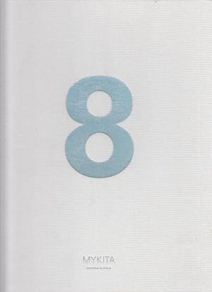
Mykita eight ( 8 ). Handmade in Berlin. Content: Mykita turns eight / Sarah Illenberger: Heads up! / Billy & Hells: View from the Blue / Modern manufactory / Kristin Loschert: Mykita Haus / Mikio Hasui: Sublime / Me, Mykita & I: Self portraits / The Mykita Story / Mark Borthwick: Ca Lume / Carl Bengtsson: Mykita Tools & Machines / Collaborations / Bernhard Willhelm: Rather XXL than XXS / Agathe Snow: I'll never dreary again / Mykita shop concept: The new Berlin shop / Innovations / Achnowledgements.
Sprache: Englisch
Verlag: Berlin: Mykita GmbH, 2011., 2011
ISBN 10: 3942989050 ISBN 13: 9783942989053
Anbieter: Antiquariat Carl Wegner, Berlin, B, Deutschland
Verbandsmitglied: GIAQ
Verkäuferbewertung 5 von 5 Sternen
Erstausgabe
Hardcover. 4° ( 30 x 23,5 cm). White canvas. 171 pages with many pictures. The cover is a little bit rubbed. Good copy. -- Weißer Originalleinenband mit einem silbergeprägten Rückentitel und einer silbergeprägten 8 auf dem Deckel. 171 Seiten mit zahlreichen Abbildungen. Innen sauber und fest. Gutes Exemplar. -- Bitte Portokosten außerhalb EU erfragen! / Please ask for postage costs outside EU! / S ' il vous plait demander des frais de port en dehors de l ' UE! // Bitte beachten Sie auch unsere Fotos! / Please also note our photos! / Veuillez noter nos photos -- Freuen Sie sich mit uns auf den Frühlingsanfang und lesen Sie einen Liebesroman aus unserer Schmonzettenecke! -- Wir kaufen Ihre werthaltigen Bücher! KuAllg.
-
The Hell's Kitchen Cookbook
Anbieter: PBShop.store US, Wood Dale, IL, USA
Verkäuferbewertung 5 von 5 Sternen
HRD. Zustand: New. New Book. Shipped from UK. Established seller since 2000.
-
The Hell's Kitchen Cookbook
Anbieter: PBShop.store UK, Fairford, GLOS, Vereinigtes Königreich
Verkäuferbewertung 4 von 5 Sternen

EUR 30,97
EUR 8,83 Versand
Versand von Vereinigtes Königreich nach USAAnzahl: 13 verfügbar
In den WarenkorbHRD. Zustand: New. New Book. Delivered from our UK warehouse in 4 to 14 business days. Established seller since 2000.
-

The science of life
Verlag: Cassell and Company, 1931
Anbieter: Cotswold Internet Books, Cheltenham, Vereinigtes Königreich
Verkäuferbewertung 5 von 5 Sternen
EUR 12,04
EUR 15,63 Versand
Versand von Vereinigtes Königreich nach USAAnzahl: 1 verfügbar
In den Warenkorb1st edition. Endpapers a little yellowed and foxed. Cloth reinforced hinges. Text clean and bright. Dark blue cloth with gilt lettering on spine; boards lightly worn at edges; front joint split and frayed, repaired; wear and small loss to spine head. This is a heavy book (about 2.7 kg packed); additional postage may be required. Used - Good. Good hardback (no dust jacket) Used - Good. Good hardback (no dust jacket).
-
The Hell's Kitchen Cookbook
Anbieter: Majestic Books, Hounslow, Vereinigtes Königreich
Verkäuferbewertung 4 von 5 Sternen
EUR 50,47
EUR 7,52 Versand
Versand von Vereinigtes Königreich nach USAAnzahl: 3 verfügbar
In den WarenkorbZustand: New. pp. 288.
-
The Hell's Kitchen Cookbook: Recipes from the Kitchen
Sprache: Englisch
Verlag: Grand Central Life & Style, 2015
ISBN 10: 1455535699 ISBN 13: 9781455535699
Anbieter: Revaluation Books, Exeter, Vereinigtes Königreich
Verkäuferbewertung 5 von 5 Sternen
EUR 43,70
EUR 17,36 Versand
Versand von Vereinigtes Königreich nach USAAnzahl: 1 verfügbar
In den WarenkorbHardcover. Zustand: Brand New. 264 pages. 12.00x10.00x1.00 inches. In Stock.
-
The Hell's Kitchen Cookbook: Recipes from the Kitchen
Sprache: Englisch
Verlag: Grand Central Life & Style, 2015
ISBN 10: 1455535699 ISBN 13: 9781455535699
Anbieter: Revaluation Books, Exeter, Vereinigtes Königreich
Verkäuferbewertung 5 von 5 Sternen
EUR 45,09
EUR 17,36 Versand
Versand von Vereinigtes Königreich nach USAAnzahl: 2 verfügbar
In den WarenkorbHardcover. Zustand: Brand New. 264 pages. 12.00x10.00x1.00 inches. In Stock.
-

Svensagas
Anbieter: Revaluation Books, Exeter, Vereinigtes Königreich
Verkäuferbewertung 5 von 5 Sternen
EUR 50,17
EUR 14,47 Versand
Versand von Vereinigtes Königreich nach USAAnzahl: 1 verfügbar
In den WarenkorbPaperback. Zustand: Brand New. 404 pages. 9.25x6.00x1.00 inches. In Stock.
-

EUR 36,23
EUR 48,99 Versand
Versand von Deutschland nach USAAnzahl: Mehr als 20 verfügbar
In den WarenkorbZustand: New.
-

The Hell's Kitchen Cookbook : Recipes from the Kitchen
Sprache: Englisch
Verlag: Grand Central Publishing Okt 2015, 2015
ISBN 10: 1455535699 ISBN 13: 9781455535699
Anbieter: AHA-BUCH GmbH, Einbeck, Deutschland
Verkäuferbewertung 5 von 5 Sternen
Buch. Zustand: Neu. Neuware - The official companion cookbook from the enormously popular Fox cooking competition show.Hell's Kitchen debuted in 2005 on Fox and is currently in in its 14th season. On the show, one explosive, charismatic Head Chef oversees 16 chefs as they battle it out to win a job as Head Chef of top restaurant with a total prize value of $250,000. In each episode the chefs are put to the test in a skill's-based challenge, and must follow it up by completing dinner service at the exclusive Hell's Kitchen restaurant set in Los Angeles. Now, in their first ever cookbook, readers will learn how to recreate over one hundred of the contestant's delectable, restaurant-worthy dishes in their own home and will be given access to the recipes, menus, and behind-the-scenes secrets that they've been craving!
-

3 Bände
Anbieter: Celler Versandantiquariat, Eicklingen, Deutschland
Verbandsmitglied: GIAQ
Verkäuferbewertung 5 von 5 Sternen
Verschiedene Verlage, . 299/379/362 Seiten. Gebunden (2) und Taschenbuch (1 Stempel auf unterem Schnitt)---- gute Exemplare. Ralph Sonny Barger. Hell's Angel/ Jay Dobyns. Falscher Engel Mein Höllentrip als Undercover-Agent bei den Hells Angels/ Bad Boy Uli. Wir sehen uns in der Hölle - 1620 Gramm.
-

Silver Wings for Vicki
Erscheinungsdatum: 1947
Anbieter: Whodunit Bookshop, Winnipeg, MB, Kanada
Verkäuferbewertung 5 von 5 Sternen
Hardcover. Zustand: Very Good.
-

Rotterdam. Oude Hoofd Poort. - Original-Stahlstich.,
Verlag: G. G. Lange 0, Darmstadt
Anbieter: Antiquariat Kastanienhof, Pirna, Deutschland
Verkäuferbewertung 5 von 5 Sternen
Softcover. Zustand: Gut. 10,5 x 15,5 cm leicht fleckig, in den Blattecken deutliche Kleberspuren früherer Tesafilmmontagen, sonst GUTES EXEMPLAR.---Schöne historische Ansicht des Hafens mit Segelschiffen, einige Personen, ein Marktstand und ein Fuhrwerk auf einer geneigten Ebene links, einige Personen auf den Booten, im Hintergrund eine Windmühle. Für Ihre Zufriedenheit versenden wir mit DHL und ausschließlich mit Trackingcode für eine sichere Sendungsverfolgung! Weitere Angebote unter antiquariat-kastanienhof , 1 Seiten. nein.
-
666: The Hymn To Lucifer
Verlag: Frank Reynolds / Hells Angels Motorcycle Club, San Francisco, 1968
Anbieter: Lorne Bair Rare Books, ABAA, Winchester, VA, USA
Verbandsmitglied: ABAA ILAB IOBA
Verkäuferbewertung 5 von 5 Sternen
Erstausgabe
First Edition. Quarto (26.75cm); twelve (12) five-color broadsides (measuring 20cm X 26cm), printed on rectos only and housed in an illustrated portfolio on glossy cardstock. A few stress creases and some subtle toning along the spine-fold of the portfolio, else Fine. An off-the-wall collection of free-form poems written by Freewheelin' Frank Reynolds, former Secretary of the San Francisco chapter of the Hells Angels Motorcycle Club. The broadsides reproduce hand-lettered, illustrated poems written by Reynolds in the mid-1960's, printed by the Diggers, and issued the year after his 1967 memoir written with Michael McClure. Content ranges from personal history and camaraderie within the club to things of a more mystical and metaphysical nature - references to Satan, astrological signs, alternately written in an optimistic tone or with a pervading sense of doom. The mystical and metaphysical realm would continue to hold Reynolds's attention through his later life. After leaving the Angels, Reynolds spent 5 years in Soldedad Prison on an arson charge; while doing time, McClure sent him a book by Zen master Shunryu Suzuki Roshi to help him clear his head, which Reynolds credited with saving his life. He spent the remaining years of his life living in the mountains next to a waterfall, where he spent his days meditating in isolation. One of the most interesting documents created by any Hells Angels club members, one that epitomizes the spirit of the 1960's and outsider art. OCLC notes 18 holdings in US institutions.
-
12 Photographs from the New Year's Wail / New Year's Whale Concert, with additional related photographs
Verlag: [San Francisco], 1967
Anbieter: Between the Covers-Rare Books, Inc. ABAA, Gloucester City, NJ, USA
Verbandsmitglied: ABAA ESA ILAB IOBA
Verkäuferbewertung 5 von 5 Sternen
Unbound. Zustand: Good. A collection of snapshots taken at the New Year's Wail concert on January 1, 1967 at the Panhandle near Golden Gate Park in San Francisco, with some accompanying images. Various sizes. Condition is overall good with tape remnants or shadows mostly in the margins. Several are captioned. The "The New Year's Wail / New Year's Whale" was organized by the Hells Angels as a thank you to, and a celebration of, the Haight Ashbury community for "crowdfunding" the bail money for their member Chocolate George after a traffic arrest. The Diggers helped to promote the event which featured Big Brother and the Grateful Dead (as well as Orkustra with Bobby Beausoleil, later of the Manson Family). The bands played on a flatbed truck, and the photographer was clearly very close to the bands, probably on the truck itself. Of the dozen candid photographs of the concert, all but one (the only color image, of some Hells Angels and their bikes in the crowd) feature the bands: Joplin appears in at least eight of them, and Jerry Garcia in three, with other shots of other band members in various combinations. Also accompanied by several other images: two color images of Joplin singing, date stamped in May 1967 (damage to the margins, although the images of Joplin are largely clear). Also with a color photo of a psychedelically decorated hippie crash pad, as well as another 14 images of several young men, presumably the photographer and his friends: one with a motorcycle, several in military garb sitting on a dock smoking pot, one on a ship's deck, and several overseas in Thailand and the Philippines.
-

'Hell Point' Battle on Mid-Northern Coast of Guadalcanal. Battle of August 21, 1942.
Erscheinungsdatum: 1943
Anbieter: Geographicus Rare Antique Maps, Brooklyn, NY, USA
Verbandsmitglied: ABAA ESA ILAB
Verkäuferbewertung 4 von 5 Sternen
Karte
Very good. Some toning. Size 26.5 x 19 Inches. This is a 1943 Donald Moss pictorial map of the 1942 Battle of Hell's Point on Guadalcanal. Guadalcanal was the first American ground offensive in the Pacific and was a critical fight to stop the Japanese advance. A Closer Look The depiction of the battle appears at center, with illustrations of Marines firing at the enemy. Moss also includes an illustration of a Marine bayonetting a Japanese soldier. Vignettes of Marine life on Guadalcanal surround the battle scene. Some highlight more mundane activities, including cooking, chopping wood, typing reports, carrying gear, and even an artist drawing something! (Possibly Moss?) Other illustrations capture important aspects of the Marine's fight for Guadalcanal, including depictions of jeeps, tents, a P-39 Airacobra in the upper right corner, an F4F Wildcat, a Stuart tank, and a Navy Destroyer. The illustration along the bottom is likely meant to depict Henderson Field, the airfield on Guadalcanal that the Japanese were building, and the Americans invaded the island to capture. The entire base is surrounded by barbed wire, and several Marines appear defending the base with one up a palm tree looking through a spyglass! The Battle at Hell's Point On August 19, two days before the battle, Marine infantrymen attacked and killed a Japanese patrol of 31 soldiers. These Japanese soldiers wore clean uniforms, marking them as new arrivals to Guadalcanal. When the Marines searched the Japanese, they discovered numerous documents, some of which were maps that showed the American positions with surprising accuracy and detail. These maps, combined with the fact that the Japanese were wearing clean uniforms, informed the Marines that new Japanese troops had landed on Guadalcanal and that they were likely to attack. The decision was made not to attack the Japanese, but to defend the territory the Marines already held. Marines fortified their lines, part of which was a sandbar that came to be known as Hell's Point. Hell's Point was a spit of land that separated Alligator Creek (which was actually a tidal lagoon and inhabited by crocodiles, not alligators) from Sealark Channel and ranged from 25 to 50 feet wide and was about 100 feet long. It also rose only 10 feet above the water. Several platoons fortified this land with .30- and .50-caliber machine guns, antitank guns, and rifle infantry. Logs and sandbags provided cover with barbed wire (strung without the benefit of gloves) strung to impede enemy progress. Marines also dug in at the center and fortified the river approaches. The Japanese attacked between 2:00 a.m. and 3:00 a.m. on August 21, expecting to easily defeat the Marines. While surprised by the entrenched position so far from Henderson Field (the Marines airstrip on Guadalcanal), the Japanese commander ordered the attack. The Marines kept up a wall of machine gun and rifle fire, only losing a few positions but quickly recapturing them. As morning broke, the carnage of the previous night became apparent. Nonetheless, the confident Japanese did not retreat, hunkering down to assault the American position again after darkness fell. However, the Marines were not keen to let them sit and wait. Instead, the Marines attacked on both sides of the river, sending a battalion reinforced with Stuart light tanks across the river further upstream while several rifle companies attacked from positions at Hell's Point. The tanks proved decisive, as the Japanese did not have any antitank weapons. By late afternoon, the battle was over, which came to be known as the Battle of the Tenaru River, and 1400 of the 1500 Japanese soldiers had been killed. The Guadalcanal Campaign The months-long battle for Guadalcanal occurred at a critical moment in the Pacific War. The Allies inflicted heavy losses on the Japanese at Midway, but the overall situation remained uncertain. The Japanese advance through Southeast Asia continued while their aggressive progress in the.
-
Map of the Glass House Farm Also the Schroepple, Ray, and other estates down to the Franklin and Robinson and the Widow Mary Clarke and Thomas B. Clarke.
Erscheinungsdatum: 1873
Anbieter: Geographicus Rare Antique Maps, Brooklyn, NY, USA
Verbandsmitglied: ABAA ESA ILAB
Verkäuferbewertung 4 von 5 Sternen
Karte
Good. Laid on fresh linen. Closed tears extending 14.5 inches into printed area from top margin. Cracking in bottom left and right quadrants. Some reinstatement to margins. No loss to printed image. Size 33.75 x 30.5 Inches. A rare 1873 John Bute Holmes cadastral map of part of the Manhattan neighborhoods Chelsea and Hell's Kitchen, New York City. It is likely the earliest obtainable specific map of this part of Manhattan. A Closer Look The map covers northern Chelsea from 27th Street to the southern part of Hell's Kitchen at 42nd Street and from the Hudson River to 8th Avenue, including the present-day mega-development of Hudson Yards. This is one of a series of 21 scarce maps drawn by Holmes between 1867 and 1875. Like all maps in this series, it was independently issued, is quite large, and impressively detailed. The maps illustrate New York City land claims as the vast early estates in central and upper Manhattan were being subdivided under eminent domain laws for assimilation into the grid system. This led to countless legal battles, much of the litigation behind which depended upon access to comprehensive cadastral maps. Breaking Up the Glass House Farm The current map illustrates the breakup of the Glass House Farm, as well as the estates of George C. Schroepple, George Rapelje, and Cornelius Ray. Some of these claims date to the early Dutch Period of New Amsterdam but were honored by the British even after the takeover. The breakup of the estates is detailed via tables in the upper right quadrant, where individual heirs and landowners are identified. Each is referenced by the New York City record book and page number. A Short History of the Glass House Farm The map's namesake, the Glass House Farm, was a large farm situated between the Hudson River and Fitzroy Road (as shown here) in today's West 30s. The unusual name, Glass House, refers to a short-lived glass factory that was established on the location in 1754. There was also a nearby tavern of the same name that, at the time of the American Revolutionary War, was a popular roadhouse and inn. The street names on this map reflect the original owners of the farm. The Lotting of Manhattan In the early 19th century, most of Manhattan was undeveloped farmland, the property of wealthy landowners with claims dating to the Dutch Period. The northern 2/3rd Manhattan was dotted with farms and sprawling gentlemanly estates, many with great manor houses overlooking the Hudson River. The Commissioner's Plan of 1811 and the 1807 Commission Law laid the street grid through many of these properties and gave the city the right to claim the lands under eminent domain, providing due compensation to the landowners. While this work occurred early in lower Manhattan, central and upper Manhattan were not formally acquired by the city until the mid-19th century. What Holmes Did and Why Holmes became fascinated by the early history of Manhattan real estate ownership, recognizing the wealth to be accrued by accurately understanding the history of city land ownership, division, and inheritance. Moreover, Holmes allied himself with the corrupt Tweed administration, assuring himself and his allies even greater wealth and political power from the eminent domain seizure of old Manhattan estates. Holmes created a series of maps, reminiscent of John Randall's 'Farm Maps', overlaid with property data, showing old estates' borders and notating the land's breakup among various heirs. The complex work of compiling the maps earned Holmes a fortune, with one newspaper suggesting on his death in 1887 that some of his individual maps were worth more than 30,000 USD. There is no complete carto-bibliography of Holmes' maps, but we believe there to be at least 50 maps, possibly more. Publication History and Census This map is rare. Only 2 examples are cataloged in the OCLC: New York State Library and another at the University of Wisconsin. References: OCLC 50560870.
-

Map of the Hermitage Farm and the Norton Estate.
Erscheinungsdatum: 1872
Anbieter: Geographicus Rare Antique Maps, Brooklyn, NY, USA
Verbandsmitglied: ABAA ESA ILAB
Verkäuferbewertung 4 von 5 Sternen
Karte
Good. Original linen exhibits some verso reinforcement. Minor wear and some damage along original fold lines. Even overall toning. Size 37 x 22.5 Inches. This is an 1872 John Bute Holmes cadastral map of the modern-day neighborhood of Hell's Kitchen in the borough of Manhattan in New York City. The map depicts the neighborhood from the Hudson River to Broadway (labeled as Bloomingdale Road) and from 48th Street to 39th Street. Highly detailed, Holmes's map provides the viewer with a look at the neighborhood as it was in 1872 and also projects an image of how it developed. Streets are labeled, and individual lots are identified by their addresses. Some elements are ghosted in using dashed lines, including Twelfth Avenue and several wharves. Hermitage Farm and Norton Estate John George Leake (1752 - 1827), a wealthy New York lawyer, counted the Hermitage Farm among his many assets. Leake, who had no children or siblings, left the farm in his will to his niece Martha Norton, with reversion to her son John Leake Norton. The rest of his fortune, in sum over $300,000, was used to found a home for orphaned children operated by Trinity Church. Holmes' 'Farm Maps' In the early 19th century most of Manhattan was undeveloped farm lands, the property of wealthy landowners with claims dating to the Dutch period of New York's history. The northern 2/3rd Manhattan was dotted with farm lands and sprawling gentlemanly estates, many with great manor houses overlooking the Hudson River. The Commissioner's Plan of 1811 and the 1807 Commission Law, laid the street grid through many of these properties and gave the city the right to claim these lands under eminent domain, providing due compensation to the landowners. While this work occurred early in lower Manhattan, central and upper Manhattan were not formally acquired by the city until the mid-19th century. Holmes became fascinated by the early history of Manhattan real estate ownership, recognizing the wealth to be accrued by accurately understanding the history of city land ownership, division, and inheritance. Moreover, Holmes allied himself with the corrupt Tweed administration, assuring himself and his allies even greater wealth and political power from the eminent domain seizure of old Manhattan estates. Holmes created a series of maps, reminiscent of John Randall's 'Farm Maps', overlaid with property data, showing the borders of old estates, and notating the breakup of the lands among various heirs. The complex work of compiling the maps earned Holmes a fortune, with one newspaper suggesting on his death in 1887 that some of his individual maps were worth more than 30,000 USD. There is no complete carto-bibliography of Holmes' maps, but we believe there to be at least 50 maps, possibly more. Provenance This map was acquired as a part of a large collection of New York cadastral maps associated with the layer Ronald K. Brown, a Deed Commissioner operating in the late 19th and early 20th century with an office at 76 Nassau Street, New York - not far from Holmes' own office. Most of the maps in the collection, including the present map, bear Brown's stamp on the verso. The maps were passed to Dominic Anthony Trotta, a real estate agent working under Brown. Brown seems to have ceased business around 1919, but Trotta continued as a real estate agent, becoming a New York Tax Commissioner in 1934 under the Fiorello H. La Guardia administration. The maps remained with Trotta's heirs until our acquisition of the collection. Publication History and Census This map was created and published by John Bute Holmes in 1872. Three examples are recorded in the OCLC as being part of the collection at Princeton University, the New York State Library, and the University of Wisconsin - Milwaukee. The Museum of the City of New York also has an example in their collection as does, we believe, the New York Public Library, although their example is uncatalogued. References: OCLC 50565877.


