Gesamtpreis (1 Artikel Artikel):
Versandziel:

hall sidney (85 Ergebnisse)
Direkt zu den wichtigsten Suchergebnissen
Produktart
- Alle Produktarten
- Bücher (46)
- Magazine & Zeitschriften
- Comics
- Noten
- Kunst, Grafik & Poster (2)
- Fotografien
- Karten (37)
-
Manuskripte &
Papierantiquitäten
Zustand
Einband
Weitere Eigenschaften
Gratisversand
Land des Verkäufers
Verkäuferbewertung
-

Paperback. Zustand: Good.
-

Christian Anti-Semitism and Paul's Theology
Verlag: 1517 Media, 1993
ISBN 10: 0800626540ISBN 13: 9780800626549
Buch Erstausgabe
Zustand: Very Good. First Edition. Former library book; may include library markings. Used book that is in excellent condition. May show signs of wear or have minor defects.
-
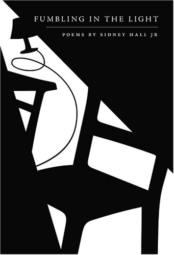
Fumbling in the Light
Verlag: Hobblebush Books, 2008
ISBN 10: 0980167221ISBN 13: 9780980167221
Anbieter: Powell's Bookstores Chicago, ABAA, Chicago, IL, USA
Bewertung:

Buch
Zustand: Used - Very Good. 2008. Hardcover. Paperback. Slight shelf-wear. Very Good.
-

Die Geisha. Eine japanische Teehausgeschichte. Text von O. Hall. Musik von S. Jones. Deutsch von C.M. Roehr und J. Freund. Die Gesangstexte sind von J. Freund.
Verlag: Berlin, Roehr o.J.
Anbieter: Musikantiquariat Bernd Katzbichler, Unterwössen, D, Deutschland
Bewertung:

32 S. [Libretto]. Umschlag und Titelseite mit Einriß.
-

Germany. Stahlstichkarte aus Encyclopćdia Britannica 1819
Verlag: Archibald Constable, Edinburgh, 1819
Karte
Zustand: Befriedigend. Stahlstichkarte von Sidney Hall, vermutlich aus der Encyclopćdia Britannica. Sidney Hall (1788??1831) war ein britischer Kupferstecher und Kartograf, der für seine Atlanten aus dem frühen 19. Jahrhundert bekannt und beliebt war. (Wikipedia) Karte auf starkem Kartonpapier, durchgängig schwach braunfleckig, Bindungsreste am oberen Rand. Beschriftung oben: PLATE CCXLVI, unten: Published by A. Constable & Co Edinburgh 1819. Engraved by Sy Hall, Bury Stt. Bloomsby. Sprache / Language: en 1 Seiten. ca. 21 x 26,6 cm.
-
Die Geisha. Eine japanische Teehaus-Geschichte. Text von Owen Hall. Musik von Sidney Jones. Deutsch von C. M. Roehr und Julius Freund. Die Gesangs-Texte sind von Julius Freund. Oper in 3 Akten.
Verlag: Berlin, C. Max Roehr o. J. []., 1924
Anbieter: WILFRIED MELCHIOR · ANTIQUARIAT & VERLAG, Spreewaldheide, Deutschland
Bewertung:
32 S. Kl.-8°. Orig.-Umschlag mit Schmuckrahmen. - Obere Ecke etwas gestaucht. * (Ein Titel aus unserem Online-Katalog "Geographie - Asien: Japan").
-
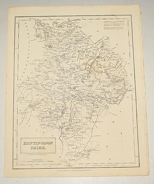
ORIGINAL ENGRAVED ANTIQUE MAP OF HUNTINGDONSHIRE.
Verlag: Published by Chapman & Hall No date 1831, 1831
Anbieter: PROCTOR / THE ANTIQUE MAP & BOOKSHOP, DORCHESTER, Vereinigtes Königreich
Verbandsmitglied: PBFA
Bewertung:
Uncoloured Unmounted. Portrait In very good condition. Faintly tanned bottom left by county name. Strong impression. Engraved surface Size 24 x 19cm.
-
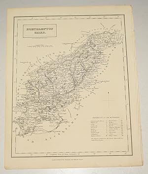
ORIGINAL ENGRAVED ANTIQUE MAP OF NORTHAMPTONSHIRE.
Verlag: Published by Chapman & Hall No date 1831, 1831
Anbieter: PROCTOR / THE ANTIQUE MAP & BOOKSHOP, DORCHESTER, Vereinigtes Königreich
Verbandsmitglied: PBFA
Bewertung:
Uncoloured Unmounted. Portrait In very good condition. Very Clean & strong impression. Engraved surface Size 24 x 19cm.
-
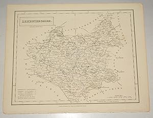
ORIGINAL ENGRAVED ANTIQUE MAP OF LEICESTERSHIRE.
Verlag: Published by Chapman & Hall No date 1831, 1831
Anbieter: PROCTOR / THE ANTIQUE MAP & BOOKSHOP, DORCHESTER, Vereinigtes Königreich
Verbandsmitglied: PBFA
Bewertung:
Uncoloured Unmounted. In very good condition. Strong impression. Engraved surface Size 24 x 19cm.
-
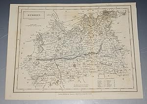
ORIGINAL ENGRAVED ANTIQUE MAP OF SURREY
Verlag: Published by Chapman & Hall 1831 1st edition, 1831
Anbieter: PROCTOR / THE ANTIQUE MAP & BOOKSHOP, DORCHESTER, Vereinigtes Königreich
Verbandsmitglied: PBFA
Bewertung:
Uncoloured Unmounted. In very good condition. With a few light folds. Very Clean & strong impression. Engraved surface Size 24 x 19cm.
-

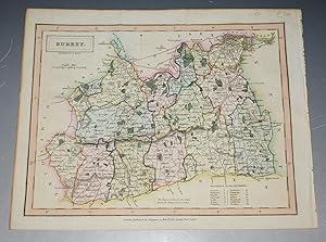
ORIGINAL ENGRAVED ANTIQUE MAP OF SURREY
Verlag: Published by Chapman & Hall 1833, 1833
Anbieter: PROCTOR / THE ANTIQUE MAP & BOOKSHOP, DORCHESTER, Vereinigtes Königreich
Verbandsmitglied: PBFA
Bewertung:
Hand coloured Unmounted with original extra text page. In very good condition. Very Clean & strong impression. Engraved surface Size 24 x 19cm.
-
ORIGINAL ENGRAVED ANTIQUE MAP OF SURREY
Verlag: Published by Chapman & Hall 1831 1st edition, 1831
Anbieter: PROCTOR / THE ANTIQUE MAP & BOOKSHOP, DORCHESTER, Vereinigtes Königreich
Verbandsmitglied: PBFA
Bewertung:
Hand coloured Unmounted. In very good condition. With a few light folds. Very Clean & strong impression. Engraved surface Size 24 x 19cm.
-
![Bild des Verkäufers für Map of Germany Parts I & II. [ taken from Black's General Atlas ] zum Verkauf von Keoghs Books](https://pictures.abebooks.com/inventory/md/md510760862.jpg)
Map of Germany Parts I & II. [ taken from Black's General Atlas ]
Verlag: Published by A & C Black no date approximately 1844, Edinburgh, 1844
Karte Erstausgabe
, double page plate 56 x 43.5 cm, numbered XXI & XXII bearing an engraved map, 47 x 37 cm, with hand coloured political boundaries, printed on heavy gilt edged paper, guard mounted First Edition thus , central fold, paper very slightly tanned, margins show some signs of handling, very good condition 56 x 43.5 cm Map ISBN:
-
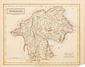
Westmoreland.
Verlag: London: 1834, 1834
Anbieter: Peter Harrington. ABA/ ILAB., London, Vereinigtes Königreich
Verbandsmitglied: ABA ILAB PBFA
Bewertung:
Published in Hall's 'A New British Atlas'. Map features a mileage scale and a numerical list of county 'Hundreds'. A fine, detailed and pleasing map of the county. Size: 215 x 275 mm. Copperplate engraving with hand colour. Slight foxing and toning. Extreme lower right corner of map is missing. Good condition.
-
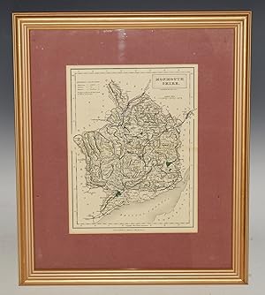
Monmouthshire. Original Hand Coloured Engraved Map.
Verlag: London, Published by Chapman & Hall, ca1840, 1840
Anbieter: PROCTOR / THE ANTIQUE MAP & BOOKSHOP, DORCHESTER, Vereinigtes Königreich
Verbandsmitglied: PBFA
Bewertung:
Karte
Original engraved antique hand-coloured map. Framed and mounted. Overall 17 x 14 inches. Engraved surface 10 x 8 inches. In very good condition. With horizontal centre fold. Some slight tanning else Good impression. Neatly coloured. Hand coloured.
-
![Bild des Verkäufers für Map of England [ taken from Walker's Atlas ] zum Verkauf von Keoghs Books](https://pictures.abebooks.com/inventory/md/md30987028384.jpg)
Map of England [ taken from Walker's Atlas ]
Verlag: Published by Longman, Hurst, Rees, Orme & Brown, London, 1823
Karte Erstausgabe
, 26 x 22 cm engraved map with hand coloured county boundaries, double page plate 2 cm margins First Edition thus , central fold, map in very good condition 26 x 22 cm Map ISBN:
-
![Bild des Verkäufers für Map of Holland [ taken from Black's General Atlas ] zum Verkauf von Keoghs Books](https://pictures.abebooks.com/inventory/md/md510760834.jpg)
Map of Holland [ taken from Black's General Atlas ]
Verlag: Published by A & C Black no date approximately 1844, Edinburgh, 1844
Karte Erstausgabe
, single page plate 43.5 x 31 cm, numbered XVIII bearing an engraved map, 25.5 x 37 cm, with hand coloured political boundaries, printed on heavy gilt edged paper First Edition thus , paper very slightly tanned, margins show some signs of handling, very good condition 43.5 x 31 cm Map ISBN:
-
![Bild des Verkäufers für Map of Sweden & Norway [ taken from Black's General Atlas ] zum Verkauf von Keoghs Books](https://pictures.abebooks.com/inventory/md/md510760838.jpg)
Map of Sweden & Norway [ taken from Black's General Atlas ]
Verlag: Published by A & C Black no date approximately 1844, Edinburgh, 1844
Karte Erstausgabe
, single page plate 43.5 x 31 cm, numbered XXVI bearing an engraved map, 25.5 x 37 cm, with hand coloured political boundaries, printed on heavy gilt edged paper First Edition thus , paper very slightly tanned, margins show some signs of handling, very good condition 43.5 x 31 cm Map ISBN:
-
![Bild des Verkäufers für Map of Italy - North Part with inset map Environs of Rome [ taken from Black's General Atlas ] zum Verkauf von Keoghs Books](https://pictures.abebooks.com/inventory/md/md510760842.jpg)
Map of Italy - North Part with inset map Environs of Rome [ taken from Black's General Atlas ]
Verlag: Published by A & C Black no date approximately 1844, Edinburgh, 1844
Karte Erstausgabe
, single page plate 43.5 x 31 cm, numbered XXXI bearing an engraved map, 25.5 x 37 cm, with hand coloured political boundaries, printed on heavy gilt edged paper First Edition thus , paper very slightly tanned, margins show some signs of handling, very good condition 43.5 x 31 cm Map ISBN:
-
![Bild des Verkäufers für Map of Italy - South Part with inset map Malta [ taken from Black's General Atlas ] zum Verkauf von Keoghs Books](https://pictures.abebooks.com/inventory/md/md510760844.jpg)
Map of Italy - South Part with inset map Malta [ taken from Black's General Atlas ]
Verlag: Published by A & C Black no date approximately 1844, Edinburgh, 1844
Karte Erstausgabe
, single page plate 43.5 x 31 cm, numbered XXXII bearing an engraved map, 25.5 x 37 cm, with hand coloured political boundaries, printed on heavy gilt edged paper First Edition thus , paper very slightly tanned, margins show some signs of handling, very good condition 43.5 x 31 cm Map ISBN:
-
![Bild des Verkäufers für Map of Prussia [ taken from Black's General Atlas ] zum Verkauf von Keoghs Books](https://pictures.abebooks.com/inventory/md/md510760848.jpg)
Map of Prussia [ taken from Black's General Atlas ]
Verlag: Published by A & C Black no date approximately 1844, Edinburgh, 1844
Karte Erstausgabe
, single page plate 43.5 x 31 cm, numbered XXIV bearing an engraved map, 25.5 x 37 cm, with hand coloured political boundaries, printed on heavy gilt edged paper First Edition thus , paper very slightly tanned, margins show some signs of handling, very good condition 43.5 x 31 cm Map ISBN:
-
![Bild des Verkäufers für Map of South America [ taken from Black's General Atlas ] zum Verkauf von Keoghs Books](https://pictures.abebooks.com/inventory/md/md510760852.jpg)
Map of South America [ taken from Black's General Atlas ]
Verlag: Published by A & C Black no date approximately 1844, Edinburgh, 1844
Karte Erstausgabe
, single page plate 43.5 x 31 cm, numbered LI bearing an engraved map, 25.5 x 37 cm, with hand coloured political boundaries, printed on heavy gilt edged paper First Edition thus , paper very slightly tanned, margins show some signs of handling, very good condition 43.5 x 31 cm Map ISBN:
-
![Bild des Verkäufers für Map of Brazil [ taken from Black's General Atlas ] zum Verkauf von Keoghs Books](https://pictures.abebooks.com/inventory/md/md510760854.jpg)
Map of Brazil [ taken from Black's General Atlas ]
Verlag: Published by A & C Black no date approximately 1844, Edinburgh, 1844
Karte Erstausgabe
, single page plate 43.5 x 31 cm, numbered LIV bearing an engraved map, 25.5 x 37 cm, with hand coloured political boundaries, printed on heavy gilt edged paper First Edition thus , paper very slightly tanned, margins show some signs of handling, very good condition 43.5 x 31 cm Map ISBN:
-
![Bild des Verkäufers für Map of Chili, La Plata and part of Bolivia [ taken from Black's General Atlas ] zum Verkauf von Keoghs Books](https://pictures.abebooks.com/inventory/md/md510760858.jpg)
Map of Chili, La Plata and part of Bolivia [ taken from Black's General Atlas ]
Verlag: Published by A & C Black no date approximately 1844, Edinburgh, 1844
Karte Erstausgabe
, single page plate 43.5 x 31 cm, numbered LIII bearing an engraved map, 25.5 x 37 cm, with hand coloured political boundaries, printed on heavy gilt edged paper First Edition thus , paper very slightly tanned, margins show some signs of handling, very good condition 43.5 x 31 cm Map ISBN:
-
![Bild des Verkäufers für Map of Colombia Peru &c. [ taken from Black's General Atlas ] zum Verkauf von Keoghs Books](https://pictures.abebooks.com/inventory/md/md510760860.jpg)
Map of Colombia Peru &c. [ taken from Black's General Atlas ]
Verlag: Published by A & C Black no date approximately 1844, Edinburgh, 1844
Karte Erstausgabe
, single page plate 43.5 x 31 cm, numbered LII bearing an engraved map, 25.5 x 37 cm, with hand coloured political boundaries, printed on heavy gilt edged paper First Edition thus , paper very slightly tanned, margins show some signs of handling, very good condition 43.5 x 31 cm Map ISBN:
-
![Bild des Verkäufers für Map of Russia in Europe. [ taken from Black's General Atlas ] zum Verkauf von Keoghs Books](https://pictures.abebooks.com/inventory/md/md510760864.jpg)
Map of Russia in Europe. [ taken from Black's General Atlas ]
Verlag: Published by A & C Black no date approximately 1844, Edinburgh, 1844
Karte Erstausgabe
, double page plate 56 x 43.5 cm, numbered XXVII & XXVIII bearing an engraved map, 47 x 37 cm, with hand coloured political boundaries, printed on heavy gilt edged paper, guard mounted First Edition thus , central fold, top left corner chipped, small brown mark (tea stain ) to map, paper very slightly tanned, margins show some signs of handling, otherwise very good condition 56 x 43.5 cm Map ISBN:
-
![Bild des Verkäufers für Map of Italy [ taken from Walker's Atlas ] zum Verkauf von Keoghs Books](https://pictures.abebooks.com/inventory/md/md510761752.jpg)
Map of Italy [ taken from Walker's Atlas ]
Verlag: Published by Longman, Orme & Co. no date givenapproximately 1823, London, 1823
Karte Erstausgabe
, 26 x 21 cm engraved map with hand coloured political boundaries, double page plate 1 cm margins First Edition thus , central fold, a little edge wear, slight tanning, otherwise map in very good condition 26 x 21 cm Map ISBN:
-
![Bild des Verkäufers für Map of Denmark [ taken from Walker's Atlas ] zum Verkauf von Keoghs Books](https://pictures.abebooks.com/inventory/md/md510761758.jpg)
Map of Denmark [ taken from Walker's Atlas ]
Verlag: Published by Longman, Orme & Co. no date givenapproximately 1823, London, 1823
Karte Erstausgabe
, 26 x 21 cm engraved map with hand coloured political boundaries, double page plate 1 cm margins First Edition thus , central fold, a little edge wear, slight tanning, otherwise map in very good condition 26 x 21 cm Map ISBN:
-
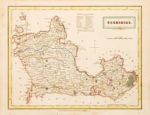
Berkshire.
Verlag: London: 1834, 1834
Anbieter: Peter Harrington. ABA/ ILAB., London, Vereinigtes Königreich
Verbandsmitglied: ABA ILAB PBFA
Bewertung:
Published in Hall's 'A New British Atlas'. Map features a mileage scale and a list of county 'Hundreds'. A fine, detailed and pleasing map of the county. Size: 215 x 275 mm. Copperplate engraving with hand colour. Slightly toned but otherwise in good condition.
-

Northamptonshire.
Verlag: London. c1835, 1835
Anbieter: Peter Harrington. ABA/ ILAB., London, Vereinigtes Königreich
Verbandsmitglied: ABA ILAB PBFA
Bewertung:
A small but detailed map of Northamptonshire, featuring a table listing the numerical county "hundreds". Published by Chapman and Hall in the "A New British Atlas". Size: 275 x 215 mm. Copperplate engraving with some hand colour Slight foxing, otherwise in very goodcondition.