
Gesamtpreis (1 Artikel Artikel):
Versandziel:

gorce john oliver la ed (6 Ergebnisse)
Direkt zu den wichtigsten Suchergebnissen
Suchfilter
Produktart
- Alle Product Types
- Bücher (3)
- Magazine & Zeitschriften (Keine weiteren Ergebnisse entsprechen dieser Verfeinerung)
- Comics (Keine weiteren Ergebnisse entsprechen dieser Verfeinerung)
- Noten (Keine weiteren Ergebnisse entsprechen dieser Verfeinerung)
- Kunst, Grafik & Poster (Keine weiteren Ergebnisse entsprechen dieser Verfeinerung)
- Fotografien (Keine weiteren Ergebnisse entsprechen dieser Verfeinerung)
- Karten (3)
- Manuskripte & Papierantiquitäten (Keine weiteren Ergebnisse entsprechen dieser Verfeinerung)
Zustand Mehr dazu
- Neu (Keine weiteren Ergebnisse entsprechen dieser Verfeinerung)
- Wie Neu, Sehr Gut oder Gut Bis Sehr Gut (Keine weiteren Ergebnisse entsprechen dieser Verfeinerung)
- Gut oder Befriedigend (3)
- Ausreichend oder Schlecht (Keine weiteren Ergebnisse entsprechen dieser Verfeinerung)
- Wie beschrieben (3)
Einband
Weitere Eigenschaften
- Erstausgabe (Keine weiteren Ergebnisse entsprechen dieser Verfeinerung)
- Signiert (Keine weiteren Ergebnisse entsprechen dieser Verfeinerung)
- Schutzumschlag (Keine weiteren Ergebnisse entsprechen dieser Verfeinerung)
- Angebotsfoto (5)
Sprache (1)
Gratisversand
- Kostenloser Versand nach USA (Keine weiteren Ergebnisse entsprechen dieser Verfeinerung)
Land des Verkäufers
Verkäuferbewertung
-

The Book of fishes.
Verlag: Washington : Nation of Geographic Society, 1939
Anbieter: Wissenschaftliches Antiquariat Köln Dr. Sebastian Peters UG, Köln, Deutschland
Verkäuferbewertung 5 von 5 Sternen

Zustand: gut. 367 S., 443 color portr., 102 biographies and 162 photogr., 25 cm, goldgeprägter Leineneinband leicht berieben, Vorblatt mit Besitzprägung, leicht gebräunt. Rev. and enl. ed. presenting the better known species of food and game fishes of the coastal and inland waters of the United States. Sprache: Deutsch.
-

National Geographic Magazine : January, 1956 - Volume CIX - Number One
Verlag: National Geographic Society, Washington DC, 1956
Anbieter: Chapter 1, Johannesburg, GAU, Südafrika
Verkäuferbewertung 5 von 5 Sternen
Softcover. Zustand: Good. No Jacket. Complete. A casually owned copy. Contents include: "Wildlife Adventuring in Jackson Hole" with the Craigheads, "Athens to Istanbul" with the Shors, "Mauritius, Island of the Dodo" with Keynes, "Portraits of My Monkey Friends" by Walker, "Wringing Secrets from Greenland's Icecap" from Victor. The covers are much worn, creased and marked from handling and storage. They are secure. The contents are mild-mannered but generous. They are clean, clear, tight, fresh-faced, competent. fk. Our orders are shipped using tracked courier delivery services.
-
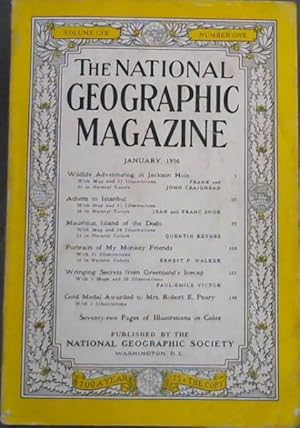
National Geographic Magazine : January, 1956 - Volume CIX - Number One
Verlag: National Geographic Society, Washington DC, 1956
Anbieter: Chapter 1, Johannesburg, GAU, Südafrika
Verkäuferbewertung 5 von 5 Sternen
Zustand: Good. No Jacket. Complete. A casually owned copy. Contents include: "Wildlife Adventuring in Jackson Hole" with the Craigheads, "Athens to Istanbul" with the Shors, "Mauritius, Island of the Dodo" with Keynes, "Portraits of My Monkey Friends" by Walker, "Wringing Secrets from Greenland's Icecap" from Victor. The covers are much worn, creased and marked from handling and storage. They are secure. The contents are mild-mannered but generous. They are clean, clear, tight, fresh-faced, competent. fk. Our orders are shipped using tracked courier delivery services.
-
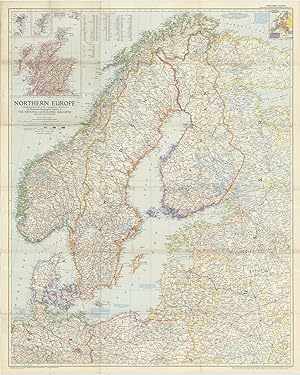
Northern Europe Compiled and Drawn in the Cartographic Section of the National Geographic Society for the National Geographic Magazine, John Oliver La Gorce, Editor. Albers Conical Equal-Area Projection, Scale 1:2,500,000 or 39.46 Miles to the Inch. Russian and Polish boundaries as of June 1, 1954 according to treaties and claims.
Verlag: Baltimore MdLithographed by A. Hoen and Co. August ., 1954
Anbieter: Robert Frew Ltd. ABA ILAB, London, Vereinigtes Königreich
Verbandsmitglied: ABA ILAB PBFA
Verkäuferbewertung 5 von 5 Sternen
Karte
EUR 59,34
EUR 11,52 Versand
Versand von Vereinigtes Königreich nach USAAnzahl: 1 verfügbar
In den WarenkorbColour printed map of Northern Europe (91 x 73.5 cm) folding to 24.5 x 15.5 cm. Showing occupation zones in Germany (American, British, Russian), principal railways, principal roads, autobahn, canals, airports, ruins. Old fold crease, generally an excellent example. (Britannica).
-
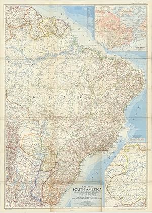
Eastern South America: Brazil, Paraguay, Uruguay, and the Guianas Compiled and Drawn in the Cartographic Section of the National Geographic Society for the National Geographic Magazine,John Oliver La Gorce, Editor. Chamberlin Trimetric Projection, Scale 1:5,000,000 or 78.91 Miles to the Inch.
Verlag: Baltimore MdLithographed by A. Hoen and Co. March ., 1955
Anbieter: Robert Frew Ltd. ABA ILAB, London, Vereinigtes Königreich
Verbandsmitglied: ABA ILAB PBFA
Verkäuferbewertung 5 von 5 Sternen
Karte
EUR 59,34
EUR 11,52 Versand
Versand von Vereinigtes Königreich nach USAAnzahl: 1 verfügbar
In den WarenkorbColour printed map of Eastern South America: Brazil, Paraguay, Uruguay, and the Guianas (103 x 73.5 cm) folding to 24.5 x 15.5 cm. Showing railways, roads, Pan American Highway, airports, oil fields, oil pipe lines, elevations in feet, depth curves and soundings in fathoms. Also with inset maps showing Continuation of Brazil on Same Scale as Main Map and Rio de Janeiro. Old fold creases, minor browning and trivial nicks along some folds. Generally a very good example.
-
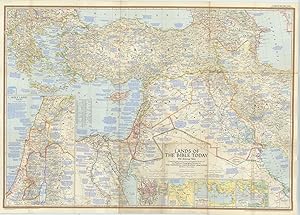
Lands of the Bible Today, with Historical Notes Compiled and Drawn in the Cartographic Section of the National Geographic Society for the National Geographic Magazine, John Oliver La Gorce, Editor. Conic Projection, Scale 1:2.851,200 or 45 Miles to the Inch.
Verlag: Baltimore MdLithographed by A. Hoen and Co. December ., 1956
Anbieter: Robert Frew Ltd. ABA ILAB, London, Vereinigtes Königreich
Verbandsmitglied: ABA ILAB PBFA
Verkäuferbewertung 5 von 5 Sternen
Karte
EUR 118,67
EUR 11,52 Versand
Versand von Vereinigtes Königreich nach USAAnzahl: 1 verfügbar
In den WarenkorbColour printed map of Lands of the Bible Today (73.5 x 103 cm) folding to 24.5 x 16 cm. Showing roads, railways, canals, principal archaeological sites, ruins, battles, oil fields, oil pipe lines, refineries, pumping stations, water holes, passes, airports, elevations in feet, soundings in fathoms. With inset maps showing Holy Land Today, Jerusalem, Traditional Route of the Exodus, St. Paul's Four Great Journeys, The Crusades. Also with copious explanatory notes detailing points of Biblical and historical interest across the map. Old fold creases, trivial browning along some folds. Generally in excellent condition.
