Gesamtpreis (1 Artikel Artikel):
Versandziel:

g w bacon ltd (10 Ergebnisse)
Feedback
Direkt zu den wichtigsten Suchergebnissen
Suchfilter
Produktart
- Alle Product Types
- Bücher (4)
- Magazine & Zeitschriften (Keine weiteren Ergebnisse entsprechen dieser Verfeinerung)
- Comics (Keine weiteren Ergebnisse entsprechen dieser Verfeinerung)
- Noten (Keine weiteren Ergebnisse entsprechen dieser Verfeinerung)
- Kunst, Grafik & Poster (Keine weiteren Ergebnisse entsprechen dieser Verfeinerung)
- Fotografien (Keine weiteren Ergebnisse entsprechen dieser Verfeinerung)
- Karten (6)
- Manuskripte & Papierantiquitäten (Keine weiteren Ergebnisse entsprechen dieser Verfeinerung)
Zustand Mehr dazu
- Neu (Keine weiteren Ergebnisse entsprechen dieser Verfeinerung)
- Wie Neu, Sehr Gut oder Gut Bis Sehr Gut (1)
- Gut oder Befriedigend (4)
- Ausreichend oder Schlecht (1)
- Wie beschrieben (4)
Einband
Weitere Eigenschaften
- Erstausgabe (2)
- Signiert (Keine weiteren Ergebnisse entsprechen dieser Verfeinerung)
- Schutzumschlag (Keine weiteren Ergebnisse entsprechen dieser Verfeinerung)
- Angebotsfoto (10)
Sprache (1)
Gratisversand
- Kostenloser Versand nach Deutschland (Keine weiteren Ergebnisse entsprechen dieser Verfeinerung)
Land des Verkäufers
Verkäuferbewertung
-
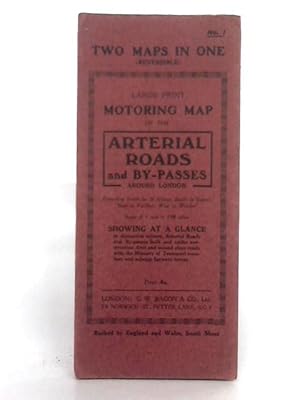
Reversible Large Print Motoring Map No.1: Arterial Roads and England & Wales: South Sheet
Verlag: G.W. Bacon & Co. Ltd, 1111
Anbieter: World of Rare Books, Goring-by-Sea, SXW, Vereinigtes Königreich
Verkäuferbewertung 5 von 5 Sternen

EUR 7,08
Währung umrechnenEUR 5,50 für den Versand von Vereinigtes Königreich nach DeutschlandAnzahl: 1 verfügbar
In den WarenkorbZustand: Fair. No Edition Remarks. Unpaginated. Red paper cover. Colour illustrated reversible map. Number 1: Arterial Roads and By-Passes, 1 inch to 1.08 miles; and England & Wales, South Sheet, 8 miles to 1 inch. Map is lightly tanned with some mild rubbed marks overall. Scuffing along folds, with some heavier tanning. Some moderate tears to folds along edges. Paper cover has mild edge wear with scuffing to edges and creasing. Mild rubbing to surfaces with curling to corners.
-
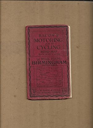
Bacon's motoring and cycling road map with route guide, 50 miles round Birmingham, Sheet8 of England. (Bacon's half-inch maps)
Verlag: G.W. Bacon & Co. Ltd
Anbieter: Gwyn Tudur Davies, Aberystwyth, Vereinigtes Königreich
Verkäuferbewertung 5 von 5 Sternen
Karte
EUR 11,80
Währung umrechnenEUR 9,39 für den Versand von Vereinigtes Königreich nach DeutschlandAnzahl: 1 verfügbar
In den WarenkorbSoft cover. Zustand: Good. No Jacket. 1 folded col. map. Covers dulled and creased, some scuffing along folds of map o/w pretty good condition. No publication date [c191-?]. [Maps - Birmingham and district - England] r390 / m14101.
-
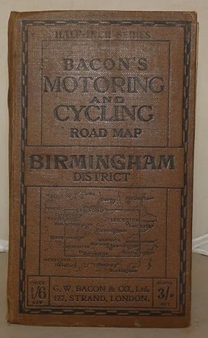
Bacon's Motoring and Cycling Road Map: Birmingham District
Verlag: G. W. Bacon & Co. Ltd., London, 1915
Anbieter: Besleys Books PBFA, Diss, Vereinigtes Königreich
Verbandsmitglied: PBFA
Verkäuferbewertung 5 von 5 Sternen
EUR 15,34
Währung umrechnenEUR 10,31 für den Versand von Vereinigtes Königreich nach DeutschlandAnzahl: 1 verfügbar
In den WarenkorbHard Cover. Zustand: Good. Hardback, folding map measuring 64cm x 89cm. Tear with small loss to 8pp Index of Towns. Map is in good order. A decent copy. (ar18).
-
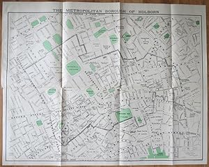
The Metropolitan Borough of Holborn.
Verlag: , 1939, 1939
Anbieter: Pennymead Books PBFA, Knaresborough, Vereinigtes Königreich
Verbandsmitglied: PBFA
Verkäuferbewertung 4 von 5 Sternen

EUR 26,20
Währung umrechnenEUR 11,45 für den Versand von Vereinigtes Königreich nach DeutschlandAnzahl: 1 verfügbar
In den WarenkorbLithograph, coloured. Scale 1: 2500. Large folding map in fine condition. 39 x 31" Drawn by J.E. Parr Borough Engineer and Surveyor.
-
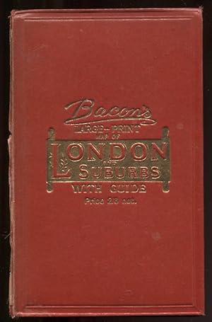
Bacon's Large-Print Map of London and Suburbs with Guide Nd C1905 Linen-Backed Map
Verlag: G. W. Bacon & Co. , Ltd, London, 1905
Anbieter: Leaf and Stone Books, Toronto, ON, Kanada
Verbandsmitglied: ABAC ILAB IOBA
Verkäuferbewertung 5 von 5 Sternen
EUR 74,55
Währung umrechnenEUR 35,76 für den Versand von Kanada nach DeutschlandAnzahl: 1 verfügbar
In den WarenkorbHardcover. Zustand: Good. Zustand des Schutzumschlags: No Dust Jacket. [iv], 62 pp. Large folding linen-backed map. Folding red cloth covers with brilliant gilt to front. Inside is a double-page ad for Chas Baker & Co, followed by a double page map of central London (scale 9 inches to a mile) , an ad for Nevill's Turkish Baths ("pronounced to be the Finest In Europe") , then the Strangers' Guide to London, including horse cab fares, an ad for Brand's Savoury meat Lozenges "world-renowned as Life Sustainers", then a number of pages of places of interest, then more ads for John Piggott, Ltd. And the Tranter's Hotel. Across from the guide is the large folding map, cloth backed, measuring 38" x 28". The guide and map are in good condition, some wear and separating at the spine of the red cloth cover but holding together well, bit of rubbing at corners. . The guide and the map are in good condition with some normal age darkening but otherwise clean and unmarked. No date but the ad for Chas Baker has typeface and clothing consistent with the 1905-1910 period. ; 8vo 8" - 9" tall.
-
![Bild des Verkäufers für [WWI] War Map Issued By The Family Herald & Weekly Star zum Verkauf von RareNonFiction, IOBA](https://pictures.abebooks.com/inventory/md/md30881224048.jpg)
[WWI] War Map Issued By The Family Herald & Weekly Star
Verlag: The Family Herald and Weekly Star, Montreal, Canada, 1918
Anbieter: RareNonFiction, IOBA, Ladysmith, BC, Kanada
Verbandsmitglied: IOBA
Verkäuferbewertung 5 von 5 Sternen
Karte Erstausgabe
EUR 258,74
Währung umrechnenEUR 34,05 für den Versand von Kanada nach DeutschlandAnzahl: 1 verfügbar
In den WarenkorbMap. Zustand: Good. First Edition. This copy bearing the ink stamp of F.R. Swanton of Davis Point, Manitoba. Frederick Swanton served in the 200th (Winnipeg) Battalion, Canadian Expeditionary Force (CEF) during WWI. Illustrated red card covers measure 8.25" x 5.5". Map folds out to 40" by 31". Undated but appears to be circa 1918. Issued as a supplement to Montreal publications The Family Herald and Weekly Star by permission G.W. Bacon & Co. Ltd., 127 Strand, London. Detailed black and white map of Europe presents the setting of World War I, presumably as a reference for Canadians following the progress of the war. Average wear. Several unobtrusive clear tape repairs. A sound vintage copy of this Canadian WWI memento with special noted provenance. Size: Double Elephant - over 25" - 50" tall.
-

Bacon's Library Map of the Environs of London.
Verlag: London G. W. Bacon & Co. Ltd. Norwich Street Fetter Lane EC4. c., 1931
Anbieter: Robert Frew Ltd. ABA ILAB, London, Vereinigtes Königreich
Verbandsmitglied: ABA ILAB PBFA
Verkäuferbewertung 4 von 5 Sternen
Karte
EUR 294,94
Währung umrechnenEUR 7,45 für den Versand von Vereinigtes Königreich nach DeutschlandAnzahl: 1 verfügbar
In den WarenkorbMap dimensions 92 x 132 cm (excluding table to right margin), overall dimensions 100 x 149 cm. Large folding map of London and the surrounding regions covering the extents from Hoddesdon down to Reigate and Canvey Island across to Windsor. Bright original colour marking out the counties, boroughs, districts and parishes. The map divided into three mile squares numbered and lettered at the borders, the grid references corresponding to a large index of local authorities found at the right margin. Printed over four conjoined sheets, the whole divided into 28 sections and mounted on linen. Folds into orginal dark green cloth slipcase, gilt lettered to the upper board. Marbled paper to folded end sections on linen verso. The slipcase slightly worn at extremities, one of the lower joints cracked at the upper edge. The map in excellent condition. The Northern Line extension from Clapham Common to Morden (opened 1926) is marked on the map. Park Royal & Twyford Abbey Station on the District (now Piccadilly) Line is also shown, the station was closed in mid 1931. Stations along the eastern extent of the District Line between Barking and Upminster (re-opened 1932), such as Upney and Becontree, are not shown.
-
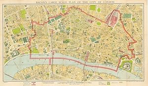
Bacon's Large Scale Plan of the City of London. .Completely revised up-to-date. Price 4/- cloth.
Verlag: LondonG. W. Bacon & Co. Ltd. 30 Museum Street, 1948
Anbieter: Robert Frew Ltd. ABA ILAB, London, Vereinigtes Königreich
Verbandsmitglied: ABA ILAB PBFA
Verkäuferbewertung 4 von 5 Sternen
Karte
EUR 294,94
Währung umrechnenEUR 7,45 für den Versand von Vereinigtes Königreich nach DeutschlandAnzahl: 1 verfügbar
In den WarenkorbMap dimensions 38 x 67 cm, overall dimensions 42 x 71 cm. Folding plan of the City, on a scale of 12 inches to the mile. The plan shows the extents from Farringdon down to Southwark and Aldgate across to Aldwych. The whole backed on linen, folding into original brown printed card wrapper with Underground map printed on verso, 16 pp. Index booklet to inner cover A serial number y/8 appears next to the copyright at the bottom left margin, presumably 1948. Certainly a post war issue as it highlights "Blitzed City Areas" (Cf. Boyle, 445.).
-

Bacon's Large Scale Plan of the City of London. .Completely revised up-to-date. Price 4/- cloth.
Verlag: LondonG. W. Bacon & Co. Ltd. 30 Museum Street, 1948
Anbieter: Robert Frew Ltd. ABA ILAB, London, Vereinigtes Königreich
Verbandsmitglied: ABA ILAB PBFA
Verkäuferbewertung 4 von 5 Sternen
Karte
EUR 294,94
Währung umrechnenEUR 7,45 für den Versand von Vereinigtes Königreich nach DeutschlandAnzahl: 1 verfügbar
In den WarenkorbMap dimensions 38 x 67 cm, overall dimensions 42 x 71 cm. Folding plan of the City, on a scale of 12 inches to the mile. The plan shows the extents from Farringdon down to Southwark and Aldgate across to Aldwych. The whole backed on linen, folding into original brown printed card wrapper with Underground map printed on verso, 16 pp. Index booklet to inner cover A fine copy. A serial number y/8 appears next to the copyright at the bottom left margin, presumably 1948. Certainly a post war issue as it highlights "Blitzed City Areas" (Cf. Boyle, 445.).
-

BEACON'S LARGE-PRINT War Map of China and Japan, MAP OF CHINA, JAPAN and KOREA, Folding MAP
Erscheinungsdatum: 1900
Karte Erstausgabe
EUR 263,13
Währung umrechnenEUR 17,02 für den Versand von Südkorea nach DeutschlandAnzahl: 1 verfügbar
In den WarenkorbNo Binding. Zustand: As New. 1st Edition. 75 x 54.5 cm.