Gesamtpreis (1 Artikel Artikel):
Versandziel:

frederik wit 1610 (34 Ergebnisse)
Direkt zu den wichtigsten Suchergebnissen
Suchfilter
Produktart
- Alle Product Types
- Bücher (14)
- Magazine & Zeitschriften (Keine weiteren Ergebnisse entsprechen dieser Verfeinerung)
- Comics (Keine weiteren Ergebnisse entsprechen dieser Verfeinerung)
- Noten (Keine weiteren Ergebnisse entsprechen dieser Verfeinerung)
- Kunst, Grafik & Poster (1)
- Fotografien (Keine weiteren Ergebnisse entsprechen dieser Verfeinerung)
- Karten (19)
- Manuskripte & Papierantiquitäten (Keine weiteren Ergebnisse entsprechen dieser Verfeinerung)
Zustand Mehr dazu
- Neu (Keine weiteren Ergebnisse entsprechen dieser Verfeinerung)
- Wie Neu, Sehr Gut oder Gut Bis Sehr Gut (Keine weiteren Ergebnisse entsprechen dieser Verfeinerung)
- Gut oder Befriedigend (34)
- Ausreichend oder Schlecht (Keine weiteren Ergebnisse entsprechen dieser Verfeinerung)
- Wie beschrieben (Keine weiteren Ergebnisse entsprechen dieser Verfeinerung)
Einband
- alle Einbände
- Hardcover (17)
- Softcover (Keine weiteren Ergebnisse entsprechen dieser Verfeinerung)
Weitere Eigenschaften
- Erstausgabe (Keine weiteren Ergebnisse entsprechen dieser Verfeinerung)
- Signiert (Keine weiteren Ergebnisse entsprechen dieser Verfeinerung)
- Schutzumschlag (Keine weiteren Ergebnisse entsprechen dieser Verfeinerung)
- Angebotsfoto (34)
Sprache (1)
Gratisversand
- Kostenloser Versand nach USA (Keine weiteren Ergebnisse entsprechen dieser Verfeinerung)
Land des Verkäufers
Verkäuferbewertung
-
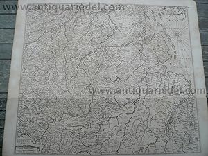
Germany/Netherlands, anno 1680, F. de Wit
Verlag: Frederik de Wit 1610 - 1698, 1698
Anbieter: Hammelburger Antiquariat, Hammelburg, Deutschland
Verkäuferbewertung 5 von 5 Sternen

Hardcover. Zustand: very good. DE WIT, F. Nova Totius Westphaliae descriptio. Amsterdam 1680 46.9 x 53.9 cm. Map of the northern provinces of Germany, including the Wad islands. West to the top. Including Hamburg, Bremen, Hildesheim, Kassel, Düsseldorf, etc. Also including the Dutch provinces of Groningen, Drente, Overijssel and Zutphen. Westorientierte Landkarte, verlegt von F. de Wit, anno 1680, gering gebräunt, etwas randrissig.
-

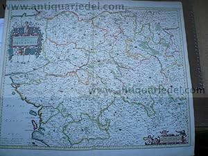
Brabantiae ducatus, anno 1690, F. de Wit map, old colours
Verlag: Frederik de Wit 1610 - 1698, 1698
Anbieter: Hammelburger Antiquariat, Hammelburg, Deutschland
Verkäuferbewertung 5 von 5 Sternen
Hardcover. Zustand: very good. Brabantiae ducatus, anno 1690, F. de Wit map, old colours Coppermap, edited by F. de Wit, anno 1690, size of the leaf: 51x60 cm., centerfold restored, little foxed, original publishers colours.
-

Flandriae Comitatus, anno 1690, map, F.de Wit, publishers colour
Verlag: Frederik de Wit 1610 - 1698, 1698
Anbieter: Hammelburger Antiquariat, Hammelburg, Deutschland
Verkäuferbewertung 5 von 5 Sternen
Hardcover. Zustand: very good. Flandriae Comitatus, anno 1690, map, F.de Wit, publishers colour Coppermap, edited by F de Wit, anno 1690, size of the leaf: 52x62 cm., publishers colours, minor cracs on margins, centerfold restored for 10 cm.
-

Limburgum Urbs, anno 1680, F.de Wit, townview
Verlag: Frederik de Wit 1610 - 1698, 1698
Anbieter: Hammelburger Antiquariat, Hammelburg, Deutschland
Verkäuferbewertung 5 von 5 Sternen
Hardcover. Zustand: very good. Limburgum Urbs, anno 1680, F.de Wit, townview Copperengraving, edited by F. de Wit, in his townbook, some cracs on margins, size of the leaf: 54x62 cm.
-

Namur, Belgium, anno 1680, F. de Wit
Verlag: Frederik de Wit 1610 - 1698, 1698
Anbieter: Hammelburger Antiquariat, Hammelburg, Deutschland
Verkäuferbewertung 5 von 5 Sternen
Hardcover. Zustand: very good. Coppermap, edited by F. de Wit, anno 1680, old colours, size of the leaf: 52x60 cm., restored centerfold, small cracs on margins, little brownish on margins.
-

Augsburg, anno 1729, F.de Wit/van der Aa, Vogelschauansicht
Verlag: Frederik de Wit 1610 - 1698, 1698
Anbieter: Hammelburger Antiquariat, Hammelburg, Deutschland
Verkäuferbewertung 5 von 5 Sternen
Hardcover. Zustand: very good. Augsburg, anno 1729, F.de Wit/van der Aa, Vogelschauansicht Augsburg. Vogelschauans. Von F. de Wit (bei P. van der Aa, 1729). Mit Legende links. 39,5:50 cm.
-
England-east,anno 1680, F de Wit, old colours
Verlag: Frederik de Wit 1610 - 1698, 1698
Anbieter: Hammelburger Antiquariat, Hammelburg, Deutschland
Verkäuferbewertung 5 von 5 Sternen
Hardcover. Zustand: very good. Coppermap, edited by F. de Wit, anno 1680, size of the leaf: 53 x 64 cm.,
-

Comitatus Hannoniae, anno 1690, F.de Wit, old colours
Verlag: Frederik de Wit 1610 - 1698, 1698
Anbieter: Hammelburger Antiquariat, Hammelburg, Deutschland
Verkäuferbewertung 5 von 5 Sternen
Hardcover. Zustand: very good. Coppermap, edited by F. de Wit, anno 1690, "COMITATUS HANNONIAE ET EPISCOPATUS CAMBRESIS DESCRIPTIO AUCTORE F. DE WIT", original contemporary colours, size of the leaf: 52 x 60 cm.little brownish.
-

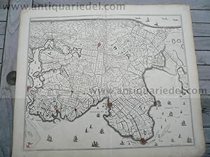
Zutphaniae comitatus, anno 1680, F. de Wit
Verlag: Frederik de Wit 1610 - 1698, 1698
Anbieter: Hammelburger Antiquariat, Hammelburg, Deutschland
Verkäuferbewertung 5 von 5 Sternen
Hardcover. Zustand: very good. Coppermap, edited by F. de Wit, anno 1680, size of the leaf: 52x60 cm., on below margin little waterstained, mostly outside of the map.
-
Mecheln/Antwerpen,anno 1690, map, F. de Wit
Verlag: Frederik de Wit 1610 - 1698, 1690
Anbieter: Hammelburger Antiquariat, Hammelburg, Deutschland
Verkäuferbewertung 5 von 5 Sternen
Karte
Hardcover. Zustand: Gut. Coppermap, edited by F. de Wit, anno 1690, size of the leaf: 52 x 60 cm., little foxed, small restoration on below centerfold.
-

Brabantiae,map,anno 1680, F.de Wit
Verlag: Frederik de Wit 1610 - 1698, 1698
Anbieter: Hammelburger Antiquariat, Hammelburg, Deutschland
Verkäuferbewertung 5 von 5 Sternen
Hardcover. Zustand: very good. Coppermap, edited by F. de Wit, anno 1680, size of the leaf: 52 x 60 cm., little brownish on margins, centerfold ok.
-
Tabula Groeningae, anno 1680, F. de Wit
Verlag: Frederik de Wit 1610 - 1698, 1698
Anbieter: Hammelburger Antiquariat, Hammelburg, Deutschland
Verkäuferbewertung 5 von 5 Sternen
Hardcover. Zustand: Gut. Tabula Groeningae, anno 1680, F. de Wit Coppermap, edited by F. de Wit, anno 1680, contemporary colours, size of the leaf: 52 x 60cm., little brownish.
-
Nova Persiae,Armeniae,Natoliae,Arabiae,anno 1690, map, F.de Wit
Verlag: Frederik de Wit 1610 - 1698, 1698
Anbieter: Hammelburger Antiquariat, Hammelburg, Deutschland
Verkäuferbewertung 5 von 5 Sternen
Hardcover. Zustand: very good. Nova Persiae,Armeniae,Natoliae,Arabiae,anno 1690, map, F.de Wit Coppermap edited by F de Wit, size of the leaf: 52 x 60 cm., on margins little waterstained. Nice map, to see the Nile River, Red Sea, Arabia, Cyprus, eastern Mediterranean, Asia Minor, Black Sea, Caspian Sea, Afganistan, Indian Ocean.
-
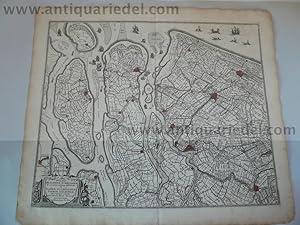
Zeelandiae comitatus, anno 1680, F. de Wit, original colours
Verlag: Frederik de Wit 1610 - 1698, 1680
Anbieter: Hammelburger Antiquariat, Hammelburg, Deutschland
Verkäuferbewertung 5 von 5 Sternen
Karte
Hardcover. Zustand: Gut. Coppermap, edited by F. de Wit, anno 1680, contemporary coloured, size of the leaf: 52x61 cm., centerfold restored, some minor cracs on margins, little brownish on margins.
-
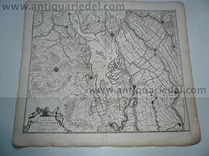
Delflandiae, Schielandiae, map, anno 1690, F.de Wit
Verlag: Frederik de Wit 1610 - 1698, 1690
Anbieter: Hammelburger Antiquariat, Hammelburg, Deutschland
Verkäuferbewertung 5 von 5 Sternen
Karte
Hardcover. Zustand: Befriedigend. Delflandiae, Schielandiae, map, anno 1690, F.de Wit Coppermap, edited by F. de Wit, anno 1690, size of the leaf: 52x60 cm., little brownish on margins, restored below centerfold for 10 cm. Including: Rotterdam, Delft, Haque, Gouda, etc.
-
Asiae tabula, generalmap, F.de Wit, anno 1690
Verlag: Frederik de Wit 1610 - 1698, 1698
Anbieter: Hammelburger Antiquariat, Hammelburg, Deutschland
Verkäuferbewertung 5 von 5 Sternen
Hardcover. Zustand: very good. Asiae tabula, generalmap, F.de Wit, anno 1690 Coppermap, edited by F. de Wit, anno 1690, size: 48 x 57 cm., little brownish, some restored cracs on margins, below centerfold restored, early generalmap with Australia and Japan. Contemporary full coloured map.
-

Africae,generalmap,F.de Wit, anno 1690
Verlag: Frederik de Wit 1610 - 1698, 1698
Anbieter: Hammelburger Antiquariat, Hammelburg, Deutschland
Verkäuferbewertung 5 von 5 Sternen
Hardcover. Zustand: very good. Africae,generalmap,F.de Wit, anno 1690 Coppermap, edited by F. de Wit, Amsterdam, anno 1690, Original full coloured, 49 x 57 cm., cracked on margins and corners, centerfold and below margins restored. Scarce map edited by de wit.
-
Gouvernement general du pays Orleanois, F.de Wit, 1680
Verlag: Frederik de Wit 1610 - 1698, 1680
Anbieter: Hammelburger Antiquariat, Hammelburg, Deutschland
Verkäuferbewertung 5 von 5 Sternen
Karte
Kein Einband. Zustand: Gut. Gouvernement general du pays Orleanois, F.de Wit, 1680 Coppermap, edited by De Wit, anno 1680, the complete course of the loire with Orleans in the center of the map. old, contemporary colours, size of the leaf: 52x62 cm., printed on thick paper, very good condition, no cracs.
-
Angliae regni, generalmap, de Wit, anno 1690
Verlag: Frederik de Wit 1610 - 1698, 1690
Anbieter: Hammelburger Antiquariat, Hammelburg, Deutschland
Verkäuferbewertung 5 von 5 Sternen
Karte
Kein Einband. Zustand: Gut. Coppermap, edited by F.de Wit, approx. anno 1690: "Accuratissima ANGLIAE REGNI et WALLIAE PRINCIPATUS Descriptio.", contemporary coloured in outline, good condition, little restoration on upper and lower centerfold, size of the view: 57 x 48 cm.
-
Over-Yssel, anno 1680, F. de Wit
Verlag: Frederik de Wit 1610 - 1698, 1680
Anbieter: Hammelburger Antiquariat, Hammelburg, Deutschland
Verkäuferbewertung 5 von 5 Sternen
Karte
Kein Einband. Zustand: Gut. Over-Yssel, anno 1680, F. de Wit Coppermap, edited by F. de Wit, anno 1680, size of the leaf: 52x61 cm., little brownish on margins.
-
Gelderland-Zutphaniae, map, anno 1690, F. de Wit, publishers col
Verlag: Frederik de Wit 1610 - 1698, 1690
Anbieter: Hammelburger Antiquariat, Hammelburg, Deutschland
Verkäuferbewertung 5 von 5 Sternen
Karte
Kein Einband. Zustand: Gut. Gelderland-Zutphaniae, map, anno 1690, F. de Wit, publishers col Coppermap, edited by F. de Wit, anno 1690, size of the leaf: 52x62 cm., publishers colours, minor cracs on margins.
-
Limburch/Valckenburch,anno 1680, F. de Wit. map, old colours
Verlag: Frederik de Wit 1610 - 1698, 1680
Anbieter: Hammelburger Antiquariat, Hammelburg, Deutschland
Verkäuferbewertung 5 von 5 Sternen
Karte
Kein Einband. Zustand: Befriedigend. Limburch/Valckenburch,anno 1680, F. de Wit. map, old colours Coppermap, edited by F. de Wit, anno 1680, size of the leaf: 52 x 60 cm., minor cracs and brownish on margins.
-
Artesiae/map, anno 1680, F.de Wit, old colours
Verlag: Frederik de Wit 1610 - 1698, 1680
Anbieter: Hammelburger Antiquariat, Hammelburg, Deutschland
Verkäuferbewertung 5 von 5 Sternen
Karte
Kein Einband. Zustand: Gut. Coppermap, edited by F. de Wit, anno 1680, size of the leaf: 52 x 61 cm., old colours, some old restorations on margins, not in the map, small restoration on below centerfold (5 cm.) "TABULA COMITATVS ARTESIAE emendata A. FREDERICO DE WIT" Contemporary coloured.
-
Suydt Hollandiae,map,anno 1680, F.de Wit
Verlag: Frederik de Wit 1610 - 1698, 1680
Anbieter: Hammelburger Antiquariat, Hammelburg, Deutschland
Verkäuferbewertung 5 von 5 Sternen
Karte
Kein Einband. Zustand: Gut. Suydt Hollandiae,map,anno 1680, F.de Wit Coppermap, edited by F. de Wit, anno 1680, size of the leaf: 52 x 60 cm., little brwonish on margins. Southern part of Holland, oriented on the top to the west. With Dordrecht, Breda, etc.
-
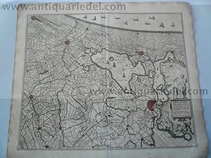
Frisiae, anno 1690, F. de Wit, publisher colours
Verlag: Frederik de Wit 1610 - 1698, 1690
Anbieter: Hammelburger Antiquariat, Hammelburg, Deutschland
Verkäuferbewertung 5 von 5 Sternen
Karte
Kein Einband. Zustand: Gut. Coppermap, edited anno 1690 by F de Wit, size of the leaf: 52x62 cm., publishers colours, waterstained on margins, minor cracs on margins.
-
Noordt Hollandt, anno 1680, map, F.de Wit
Verlag: Frederik de Wit 1610 - 1698, 1680
Anbieter: Hammelburger Antiquariat, Hammelburg, Deutschland
Verkäuferbewertung 5 von 5 Sternen
Karte
Kein Einband. Zustand: Gut. Noordt Hollandt, anno 1680, map, F.de Wit Coppermap, edited by F de Wit, anno 1680, size of the map: 45x54 cm., little brownish on margins, little restoration on upper centerfold.
-
Rijnland/Amstelandiae, anno 1680, map, F.de WitRhenen, anno 1630
Verlag: Frederik de Wit 1610 - 1698, 1680
Anbieter: Hammelburger Antiquariat, Hammelburg, Deutschland
Verkäuferbewertung 5 von 5 Sternen
Karte
Kein Einband. Zustand: Befriedigend. Rijnland/Amstelandiae, anno 1680, map, F.de WitRhenen, anno 1630 Copperengraving, edited anno 1630, size of the view: 10 x 15 cm. Coppermap, edited by F. de Wit, "RHINOLANDIAE AMSTELANDIAE, ." approx. anno 1680, size of the leaf: 52x60 cm., below centerfold restored for 18 cm. Scarce map, not found in the web.
-
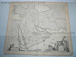
Balkan/Romania/anno 1680, map by F.de Wit
Verlag: Frederik de Wit 1610 - 1698, 1680
Anbieter: Hammelburger Antiquariat, Hammelburg, Deutschland
Verkäuferbewertung 5 von 5 Sternen
Karte
Kein Einband. Zustand: Gut. Balkan/Romania/anno 1680, map by F.de Wit "Nova totius Hungariae, Transilvaniae, Serviae, Romaniae, Bulgariae, Walachiae, Moldaviae, Sclavoniae, Croatiae, Bosniae, Dalmatiae Maximaeqss partis Danubii Fluminis Descriptio" Frederick de Wit 57 x 44 cm., map, 52x60 cm., leaf., original publishers colours, little brownish, small restored tears on margins This is a beautiful map of the Balkans filled with detail of cities, villages, roads and topography. The fine title cartouche features a Christian knight and a Muslim prince offering each other olive branches. In the center of the map the river Danube from Vienna to the Black Sea.
-
De Noorderlyckste Zee kusten van America, F.de Wit, anno 1680
Verlag: Frederik de Wit 1610 - 1698, 1680
Anbieter: Hammelburger Antiquariat, Hammelburg, Deutschland
Verkäuferbewertung 5 von 5 Sternen
Karte
Kein Einband. Zustand: Gut. De Noorderlyckste Zee kusten van America, F.de Wit, anno 1680 "De Noorderlyckste Zee kusten van America van Groenland door de Straet Davis ende Straet Hudson tot Terra Neuf". Grenzkol. Kupf.-Kte. (aus F. de Wit, Orbis Maritimus, 1680). Mit 2 ausgem. fig. Kart. mit lat.-holl. Titeln sowie Schiffsstaffage. 48:56 cm. Seekarte mit dem Gebiet um Baffin Island mit Baffin- u. Hudson ("Button") Bay. Hier ohne die Num. - Gereinigt; tlw. noch etwas braunfleckig. Mehrere Randeinrisse u. Koloritbrüche hinterklebt; komplett mit Japanpapier verstärkt. Seachart of Arctic Canada and parts of Greenland. From de Wit's 2nd ed. without numbering. - Contemp. col. in outline, cartouches col. Washed, still some spotting in places. Repairs to several small tears and cracks caused through col. oxidation; completely strengthened with fine tissue.
-
Tabula Russia, map, F.de Wit, anno 1690, old coloured
Verlag: Frederik de Wit 1610 - 1698, 1690
Anbieter: Hammelburger Antiquariat, Hammelburg, Deutschland
Verkäuferbewertung 5 von 5 Sternen
Karte
Kein Einband. Zustand: Gut. Coppermap, contemporary coloures, edited by F. de Wit, anno 1690, "Tabula RUSSIA vulgo MOSCOVIA", size of the leaf: 52 x 62 cm., little brownish, below centerfold for 7 cm. restored.