Gesamtpreis (1 Artikel Artikel):
Versandziel:

francois halma (29 Ergebnisse)
Direkt zu den wichtigsten Suchergebnissen
Suchfilter
Produktart
- Alle Product Types
- Bücher (23)
- Magazine & Zeitschriften (Keine weiteren Ergebnisse entsprechen dieser Verfeinerung)
- Comics (Keine weiteren Ergebnisse entsprechen dieser Verfeinerung)
- Noten (Keine weiteren Ergebnisse entsprechen dieser Verfeinerung)
- Kunst, Grafik & Poster (1)
- Fotografien (Keine weiteren Ergebnisse entsprechen dieser Verfeinerung)
- Karten (5)
- Manuskripte & Papierantiquitäten (Keine weiteren Ergebnisse entsprechen dieser Verfeinerung)
Zustand Mehr dazu
- Neu (8)
- Wie Neu, Sehr Gut oder Gut Bis Sehr Gut (2)
- Gut oder Befriedigend (2)
- Ausreichend oder Schlecht (Keine weiteren Ergebnisse entsprechen dieser Verfeinerung)
- Wie beschrieben (17)
Einband
Weitere Eigenschaften
- Erstausgabe (1)
- Signiert (1)
- Schutzumschlag (Keine weiteren Ergebnisse entsprechen dieser Verfeinerung)
- Angebotsfoto (21)
Sprache (3)
Preis
- Beliebiger Preis
- Weniger als EUR 20 (Keine weiteren Ergebnisse entsprechen dieser Verfeinerung)
- EUR 20 bis EUR 45
- Mehr als EUR 45
Gratisversand
- Kostenloser Versand nach USA (Keine weiteren Ergebnisse entsprechen dieser Verfeinerung)
Land des Verkäufers
Verkäuferbewertung
-

Woordenboek Der Nederduitsche En Fransche Taalen
Anbieter: Ria Christie Collections, Uxbridge, Vereinigtes Königreich
Verkäuferbewertung 5 von 5 Sternen

EUR 38,06
EUR 13,73 Versand
Versand von Vereinigtes Königreich nach USAAnzahl: Mehr als 20 verfügbar
In den WarenkorbZustand: New. In.
-

Le Grand Dictionnaire François Et Flamand, Tiré De L'usage Et Des Meilleurs Auteurs; Volume 1
Anbieter: Ria Christie Collections, Uxbridge, Vereinigtes Königreich
Verkäuferbewertung 5 von 5 Sternen
EUR 42,25
EUR 13,73 Versand
Versand von Vereinigtes Königreich nach USAAnzahl: Mehr als 20 verfügbar
In den WarenkorbZustand: New. In.
-

Woordenboek Der Nederduitsche En Fransche Taalen
Anbieter: Ria Christie Collections, Uxbridge, Vereinigtes Königreich
Verkäuferbewertung 5 von 5 Sternen
EUR 47,50
EUR 13,73 Versand
Versand von Vereinigtes Königreich nach USAAnzahl: Mehr als 20 verfügbar
In den WarenkorbZustand: New. In.
-

Le Grand Dictionnaire François Et Flamand, Tiré De L'usage Et Des Meilleurs Auteurs; Volume 1
Anbieter: Ria Christie Collections, Uxbridge, Vereinigtes Königreich
Verkäuferbewertung 5 von 5 Sternen
EUR 47,50
EUR 13,73 Versand
Versand von Vereinigtes Königreich nach USAAnzahl: Mehr als 20 verfügbar
In den WarenkorbZustand: New. In.
-

Woordenboek Der Nederduitsche En Fransche Taalen
Sprache: Englisch
Verlag: Creative Media Partners, LLC Jul 2023, 2023
ISBN 10: 1021288438 ISBN 13: 9781021288431
Anbieter: AHA-BUCH GmbH, Einbeck, Deutschland
Verkäuferbewertung 5 von 5 Sternen
Taschenbuch. Zustand: Neu. Neuware - This comprehensive language dictionary offers translations between Dutch, French, and other languages. It is considered one of the most authoritative dictionaries in its field, and has been used by academics and students for generations. It is a valuable resource for language students, translators, and linguists.
-

Le Grand Dictionnaire François Et Flamand, Tiré De L'usage Et Des Meilleurs Auteurs; Volume 1
Sprache: Englisch
Verlag: Creative Media Partners, LLC Jul 2023, 2023
ISBN 10: 1021526916 ISBN 13: 9781021526915
Anbieter: AHA-BUCH GmbH, Einbeck, Deutschland
Verkäuferbewertung 5 von 5 Sternen
Taschenbuch. Zustand: Neu. Neuware.
-

Woordenboek Der Nederduitsche En Fransche Taalen
Sprache: Englisch
Verlag: Creative Media Partners, LLC Jul 2023, 2023
ISBN 10: 1019509457 ISBN 13: 9781019509456
Anbieter: AHA-BUCH GmbH, Einbeck, Deutschland
Verkäuferbewertung 5 von 5 Sternen
Buch. Zustand: Neu. Neuware - This comprehensive language dictionary offers translations between Dutch, French, and other languages. It is considered one of the most authoritative dictionaries in its field, and has been used by academics and students for generations. It is a valuable resource for language students, translators, and linguists.
-

Le Grand Dictionnaire François Et Flamand, Tiré De L'usage Et Des Meilleurs Auteurs; Volume 1
Sprache: Englisch
Verlag: Creative Media Partners, LLC Aug 2024, 2024
ISBN 10: 1020180803 ISBN 13: 9781020180804
Anbieter: AHA-BUCH GmbH, Einbeck, Deutschland
Verkäuferbewertung 5 von 5 Sternen
Buch. Zustand: Neu. Neuware - A comprehensive French-Flemish dictionary compiled by François Halma in the late 17th century. The dictionary includes over 60,000 entries and is regarded as one of the most important early modern language references. It is an invaluable resource for scholars and historians studying the French language and culture of the period.
-

Le Grand Dictionnaire François et Flamand. Tiré de l'usage et des meilleurs auteurs. - Het Groot Fransch en Nederduitsch Woordenboek. Uit het gebruik, en uit de beste schryveren met behulp van voornaame taalkundigen opgesteld
Verlag: J. De Wetstein - J. van Poolsum, Leide - Utrecht, 1761
Anbieter: Societe des Bollandistes, Bruxelles, Belgien
Verkäuferbewertung 5 von 5 Sternen
Full-Leather. Zustand: Very Good. 5e éd. 868 pp. Ce volume contient le dictionnaire Français-Flamand. Reliure plein cuir. Mors fendu dans la partie inférieure. Size: 4to - over 9ľ" - 12" tall. Ex-Library.
-
Tooneel der Vereenigde Nederlanden, En onderhorige landschappen, Geopent en een Algemeen Historisch, Genealogisch En Staatskundig Woordenboek.
Verlag: Leeuwaarden, Hendrik Halma, 1725., 1725
Anbieter: Antiquariaat Garcia, Mechelen, Belgien
Verbandsmitglied: ILAB
Verkäuferbewertung 2 von 5 Sternen

2 parts in 1 vol in-folio. [14] 470 pp, 408 pp. Contemporary full leather, spine gone and covered with glazed calico. Dutch history illustrated with 36 full-page engraved portraits of noble man, and 26 double page engraved maps (some folding). Browning throughout, nasty restoration with black tape on the last page, else good copy.
-

Tooneel der Vereenigde Nederlanden, en onderhorige landschappen, Geopent in een Algemeen historisch, genealogisch, geographisch, En staatkundig woordenboek, Waar in de Aloude, de Opvolgende en Hedendaagsche Staat dezer gewesten naar de orde van 't A.B.C. ontvouwen en opgeheldert wordt.Met nauwkeurige Landkaarten en fraaie Printverbeeldingen versiert. 2 Vols. in 1 binding.
Verlag: Leeuwarden; 1725, 1725
Anbieter: Antiquariaat De Boekenbeurs, Middelburg, Niederlande
Verkäuferbewertung 4 von 5 Sternen

EUR 1.210,00
EUR 15,50 Versand
Versand von Niederlande nach USAAnzahl: 1 verfügbar
In den Warenkorb; Hendrik Halma. 2 Vols. in one full calf binding with gilt decorated spine; folio; (30), 470, (10), 408 pp. Portrait of Halma; 9 contemporaine maps: The Netherlands, 7 Provinces and Passage near Panderen, 17 historical maps and 38 other engravings (mostly portraits). In very good condition; binding professionally restored.
-
Woordenboek der nederduitsche en Fransche Taalen . / Dictionnaire flamand et francois .
Verlag: Wetsteins en Smith, Amsterdam / Jacob van Poolsum, Utrecht 1729., 1729
Anbieter: Cassiodor Antiquariat, Gauting, Deutschland
Verkäuferbewertung 4 von 5 Sternen
4°, binding is half-leather, woodcut-title, title, 6 leaves, 1005 pages. Woordenboek der nederduitsche en Fransche Taalen . door Francois Halma. Tweede Druk, naauwkeurig overzien, verbeterd . / Dictionnaire flamand et francois . par Francois Halma. Seconde edition, revue avec soin, corrigée, purgée d'une infinité de fautes & augmentée tout au moins d'un tiers. Rücken mit Läsur, Vorsatz mit Vermerk und Stempel, Deckel leicht gelockert, fleckig, Einband stark berieben, sonst gut / minor traces of use.
-
Kanaän en d'Omleggende Landen, vertoont in een woordenboek uit de h. schrift en Josephus, van alle Steden, Vlekken, Dorpen, Gehuchten, Bergen, Stroomen, enz. van't Joodtsche Landt, en de Landtstreeken der aangrenzende Volken; met de aaloude geschiedenissen dier tyden verknocht
Verlag: François Halma, Leeuwarden, 1717
Anbieter: ERIC CHAIM KLINE, BOOKSELLER (ABAA ILAB), Santa Monica, CA, USA
Verkäuferbewertung 4 von 5 Sternen
Erstausgabe
Hardcover. Zustand: Good+. First Dutch translation. Quarto. [14], 64, [2], 559, [1]pp. Original full calf (lightly worn) with gold lettering and tooling on spine. Raised bands. Decorative paper edges. Engraved title page depicting Moses and Aaron dividing the land of Israel. Title page in red and black lettering. Decorative initials and tailpieces. Remarkable collection of aids to the study of biblical history by a variety of 17th-century Christian scholars such as the Jesuit Jacques Bonfrčre, French cartographer Nicolas Sanson, and Professor Johannes de Klerk. Dictionary of biblical names and places. Also includes a guide to the Holy Land by Buchardus de Monte Sion, Henry Maundrell's description of the territory from Aleppo to Jerusalem, with a letter to Bishop Thomas Rochester and a biblical timeline by Arnaud d'Andilly translated by H. Tydtrekening. This work is exquisitely illustrated with 30 stunning engraved maps and views of the Holy Land, including Mount Carmel, Damascus, Jaffa, Mount Tabor, Temple of Solomon, and a fine large view of Jerusalem, drawn after Dapper Hollar's view on a reduced scale. Moderate rubbing on binding. Head of spine partly chipped. Minor offsetting and foxing on endpapers. Minor and sporadic age-toning throughout. Text in Dutch. Binding in overall good- to good, interior in very good condition.
-

Uitbeeldinge der Heerlijkheit Friesland. Zoo in 't algemeen, als in haare 30 bijzondere Grietenijen
Anbieter: Celler Versandantiquariat, Eicklingen, Deutschland
Verbandsmitglied: GIAQ
Verkäuferbewertung 5 von 5 Sternen
Theatrum Orbis Terrarum B.V., Amsterdam/De Tille B.V., Leeuwarden, 1979. 180, II, 16, 2 S. mit 37 doppelblattgroßen Karten, einer allegorischen Tafel, 3 heraldischen Tafeln, goldgeprägter Kunstleder-Einband, Imperial-Folio (ca. 32,5 x 54,2 cm), (Vordergelenk geplatzt)---- Reprint der Ausgabe 1718 / Fryske Akademy (Nr. 362) - 2940 Gramm.
-
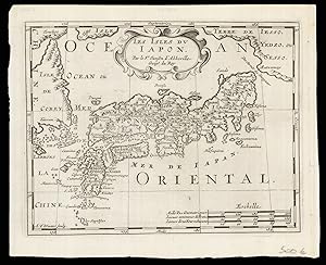
Les Isles dv Iapon
Verlag: Chez Arnout van Ravenstein, 1699]., [Amsterdam,, 1699
Anbieter: Daniel Crouch Rare Books Ltd, London, Vereinigtes Königreich
Verbandsmitglied: ABA ILAB PBFA
Verkäuferbewertung 5 von 5 Sternen
Karte
EUR 177,06
EUR 22,92 Versand
Versand von Vereinigtes Königreich nach USAAnzahl: 1 verfügbar
In den WarenkorbSecond state of Halma's pirated edition of Sanson's map of Japan Engraved map. Second state of the plate, first published in Halma's pirated edition of Sanson's 'L'Asie en plvsiers cartes nouvelles, et exactes;', as part of 'L'Europe; L'Asie; L'Amerique en Pluiers Cartes', 1683. A direct copy of Sanson's map of 1652, the only differences being the lack of a privilege and a date in the cartouche, the addition of the signature of the engraver, Antoine de Winter in the lower left corner. This issue is distinguished by the addition of mountains added in 'Isle de Corey' and 'Terre de Iesso'; and the 'Mer de Japan' above 'Oriental'. Francois Halma (1653-1722) set up his printing business in Utrecht in 1674, where he issued a number of pirated maps and atlases. In this instance, since Sanson was dead, Halma may have felt that there no harm and much profit to be gained from re-printing his work. The engraver, Antoine de Winter (c1652-1700) achieved some notoriety for plagiarizing Petter Gedda's charts of the Baltic Sea, selling them on to Loots and Doncker, for inclusion in their atlases, who were subsequently sued, and ordered to surrender the plates and pay a fine of 300 florins. Sanson originally credited "Caardin [sic], Varenius" and 'others' for his map. Generally, the geography follows that of Moreira/Blancus, only a small portion of the eastern coast of Korea is shown, without stating whether it is an island or not, and there is only a hint of Hokkaido in the far northeast corner with the place name Matzumay. Varenius, or Bernhard Varen (fl1622-1650) was a German physician, geographer and natural historian. He settled in Amsterdam, and was a friend of the Blaeu family. He published 'Descriptio regni Japonia' in 1649, and came to be known as 'the father of physical geography' (Hubbard). Sanson (1600-1667) was a French mapmaker. He supposedly began to make maps to supplement his study of history, and a map of Ancient Gaul made early in his career brought him to the attention of Cardinal Richelieu. This foothold in the French court allowed him to rise to the position of Geographe du Roi, teaching both Louis XIII and Louis XIV. Louis XIII even made him a counsellor of state. Sanson produced an atlas, 'Cartes Generales de Toutes les Parties du Monde', which contained important maps of the post roads and waterways of France. He also produced two major maps of North America: 'Amerique Septentrionale' (1650) was the first map to show the Great Lakes in a recognisable form,aided by Sanson's access to The Jesuit Relations, a collection of accounts by French missionaries to the area. The map was also drawn on a sinusoidal projection, which Sanson was the first to use. In 1656, he made 'Le Canada ou Nouvelle France', which showed the Great Lakes in greater detail, and included accurate representations of the Hudson Bay area, the Delaware and the Gulf of Saint Lawrence.After Sanson's death the business was carried on by his two surviving sons and grandson, in partnership with Hubert Jaillot. Sanson family members were revered among the foremost map makers in France for nearly a century. A leading exemplar of the French school of seventeenth-century cartography, Nicholas Sanson I is widely regarded as the founder of modern geography, and it is generally held that the so called "Great Age" of French cartography originated with his publications Hubbard 51.2.
-
Heilige feestgezangen, behelzende de geboort en 't lyden des Heilants, zyne opstandinge, hemelvaart, verhooginge aan Godts rechte hand, en de zending van de H. Geest. Hier komt by De zegepraal des geloofs, of eene uitbreinge van het gansche XI hooftstuk
Verlag: Leeuwarden, Francois Halma 1718 geillustreerd, 1718
Anbieter: Antiquarian Bookshop Klikspaan, Leiden, Niederlande
Verkäuferbewertung 4 von 5 Sternen
2e druk, nauwkeurig overzien, ook met kanttekeningen en eenige nieuw stukken vermeerdert. - 472 pag. - Perkamenten band.
-

Descriptio Batavorum Insulae et Continentis. Auctore Mensone Alting.
Verlag: Artist: Halma Francois ( - 1722 ) Leeuwarden; issued in: Leeuwarden; ca: 1722, 1653
Anbieter: Antique Sommer& Sapunaru KG, München, Deutschland
Verkäuferbewertung 4 von 5 Sternen
Technic: Copper print, colorit: original colored, condition: Tears perfectly restored, size (in cm): 32 x 42 cm, Map shows a part of the Netherlands with the Rhine and two magnificent cartouches. From the atlas ?Toonneel der Vereeigden Nederlanden en Onderhoorige Landschappen?, cartographer: Menso Alting, 1541-1612 in Emden.
-
Het kasteel van Aigermont, en d'omleggende landtstreeken in de heerlykheit van Nederkan, nevens de stadt Maastricht.
Verlag: François Halma,, Leeuwarden,, 1715
Anbieter: Antiquariaat FORUM BV, Houten, Niederlande
Verkäuferbewertung 5 von 5 Sternen
EUR 6.500,00
EUR 25,00 Versand
Versand von Niederlande nach USAAnzahl: 1 verfügbar
In den WarenkorbFirst and only edition of a Dutch poem in praise of Château Agimont, now known as Château Neercanne, and the nearby city of Maastricht. It starts with a six-page verse dedication to Daniel Wolf, Baron van Dopff, who had the chateau rebuilt in Dutch Baroque architecture in 1698, followed by an acknowledgement in verse to the Maastricht city officials, and a four-page note to the reader. Included at the end as an appendix, is a Dutch translation of a Latin speech in praise of poetry. The double-page plates show the chateau with its large terrace gardens (and a ship sailing in the artificial lake), a panoramic view of the city of Maastricht, and the great stone-vaulted interior of the St. Pietersberg limestone quarry south of Maastricht. The chateau is built on a man-made terrace on the side of a hill (unique in the Netherlands) and remains, together with the quarry, a popular tourist attraction. The plate of the chateau, and probably the other illustrations, were drawn by Guillaume de Bruyn (1649-1719) and engraved by J. Karrewyn. The author, François Halma (1653-1722), was not only a poet but also a printer, publisher, and bookseller, and his engraved device includes a printing press (modestly giving centre stage to a view of Constantine's victory). On its publication in 1715, Halma's work received an enthusiastic 19-page report in Boekzaal der geleerde wereld, which gave particular attention to the typography.The spine is slightly rubbed, a scratch on the back board, with some loss of material. The leaves are lightly browned. Otherwise in very good condition.l Nijhoff-van Hattum 126; NNBW 6; STCN 157157407 (5 copies). Contemporary gold-tooled sprinkled polished calf, with a brown morocco title label on the spine, lettered in gold, gold-tooled board edges, blue decorate edges, marbled end papers. With the title page and dedication printed in red and black, an engraved printer's device on the title page, 3 engraved plates (2 folding, 1 double page), 4 decorated woodcut initials, and 2 woodcut tailpieces. Pages: [20], 60 pp.
-
Het kasteel van Aigermont, en d'omleggende landtstreeken in de heerlykheit van Nederkan, nevens de stadt Maastricht; in heldendicht afgeschetst door François Halam. Hier is bygevoegt eene rede tot lof der dichtkunde.
Anbieter: Librairie L'Abac / Gimmic SRL, Bruxelles, Belgien
Verbandsmitglied: ILAB
Verkäuferbewertung 5 von 5 Sternen
Te Leeuwarden, François Halma, 1715. Un volume relié (20,5 x 29 cm) de 9 ff., 60 pages et 3 planches double-page dépliantes hors texte. Relire demi veau, dos ŕ nerfs. Coiffe sup. absente, coiffe inférieure abimée, mais bon exemplaire et planches en trčs bel état de fraîcheur. Edition unique trčs rare de ce long počme élogieux sur Château Neercanne et la ville de Maastricht, écrit par le prolifique imprimeur, éditeur et libraire hollandais F. Halma. Illustré avec 3 belles planches montrant le château et ses grands jardins en terrasse, une grande vue panoramique de Maastricht et une vue de la carričre souterraine de calcaire sous le mont Saint-Pierre ("St. Pieters Bergh par Maastricht soo als die sich onder de Aarde vertoont"), montrant les deux carriers au travail et des touristes en pantalon fantaisie recevant une visite guidée dans la grotte artificielle. Le château de Neercanne (ou "d'Agimont", ŕ ne pas confondre avec le château voisin d'Aigremont au sud-ouest de Ličge) est situé juste au sud de Maastricht, et juste au nord des villages belges de Kanne (Limbourg) et Eben- Emael (Ličge), sur un site déjŕ utilisé par les Romains. Le bâtiment actuel, de style baroque néerlandais, a été conçu et construit en 1698 par Daniël Wolf van Dopff (1650-1718), seigneur de Neercanne, gouverneur militaire de Maastricht et dédicataire du livre de Halma, comme résidence de campagne pour les fętes et comme maison d'hôtes. Son invité le plus célčbre était le tsar russe Pierre le Grand en 1717, lors de son deuxičme voyage aux Pays-Bas. Le château de Neercanne est le seul château en terrasse du Benelux. Livres.
-
![Bild des Verkäufers für Tooneel der Vereenigde Nederlanden, en onderhorige landschappen, geopent in een algemeen historisch, genealogisch, geographisch, en staatkundig woordenboek. [two volumes] zum Verkauf von Frans Melk Antiquariaat](https://pictures.abebooks.com/inventory/md/md31251856047.jpg)
Tooneel der Vereenigde Nederlanden, en onderhorige landschappen, geopent in een algemeen historisch, genealogisch, geographisch, en staatkundig woordenboek. [two volumes]
Anbieter: Frans Melk Antiquariaat, HILVERSUM, Niederlande
Verkäuferbewertung 5 von 5 Sternen
Hendrik Halma, 1725. Two volumes. 40 x 27 cm. Brown leather bindings (worn, hinges not tight). With various engravings and 26 (fold-out) maps. 470, 408 pag. Some pages browned and slightly stained, traces of use. Rare encyclopeadic book on places and names. [Topography / Dutch [Nederlandse Topografie] Bijzonder / Special [Bijzonder] Encyclopedie ].
-
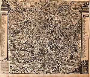
Antiquae Urbis Romae Imago
Verlag: Amsterdam, 1704
Anbieter: Libreria Pontes, Madrid, M, Spanien
Verkäuferbewertung 5 von 5 Sternen
Karte
Sin Encuadernar. Zustand: Excelente. Large view of Rome based on Pirro Ligorio famous plan printed in 1561.The view represents a reconstruction of Rome during the reign of Augustus. Two columns at sides list 269 monuments represented in the plate.Ligorio´s plan was the model for Braun Hogenberg and later plans of Rome for the XVII century.
-
"Tabula Geographica Terra Sanctae" - Israel Palestine Holy Land map Karte
Sprache: Deutsch
Verlag: Amsterdam, 1700
Anbieter: Antiquariat Steffen Völkel GmbH, Seubersdorf, Deutschland
Verkäuferbewertung 5 von 5 Sternen
Kunst / Grafik / Poster
Original Kupferstich-Karte von ca. 1700. -- Von 2 Platten gedruckt, zusammensetzbar. -- Blatt-Maße: je Karte ca. 37 x 25 cm. -- gut erhalten. || Original copper engraved map from c. 1700. -- Printed on two plates, can be joined together. -- in good condition. // Wir, das Antiquariat Steffen Völkel, kaufen und verkaufen alte Bücher, Handschriften, Zeichnungen, Autographen, Grafiken und Fotografien. Wir sind stets am Ankauf von kompletten Bibliotheken, Sammlungen und Nachlässen interessiert. Sprache: Deutsch Gewicht in Gramm: 10.
-
Bust portrait in oval of David van Hoogstraten (1658-1724). Van Hoogstraten was a Dutch physician, poet and linguist. He studied medicine in Leiden and worked as a doctor in Dordrecht. He was a teacher at a grammar school in Amsterdam, where he from 1694 to 1722 was also vice principal. As linguist he contributed to determine the gender of words, using the work of Vondel and Hooft as reference. In 1704 he published a Latin-Dutch dictionary. Inscribed in oval frame: 'DAVID VAN HOOGSTRATEN MEDICINAE DOCTOR.' signed below: 'A. Boonen pinxit. / P. van Gunst sculpsit. / F. Halma excudit.' Four lines of text in Latin at the bottom, by Janus Brokhusius. Published in ca. 1720 l Engraving on paper with small margins; plate mark: 302 x 233 mm, total: 323 x 245 mm; pasted on thicker paper, in good conditions. Van Someren 2574.
-

Madrid.
Erscheinungsdatum: 1705
Anbieter: Antiquariaat Dat Narrenschip, Middelburg, Niederlande
Verkäuferbewertung 5 von 5 Sternen
Karte
No Binding. Zustand: Fine. Antique print with a view of Madrid. Backside blank. Copper engraving, published in Leeuwarden in 1705 in "Algemene Wereldtbeschrijving," Francois Halma. Dimensions (image): 19 x 27 cm.
-

Woordenboek der Nederduitsche & Fransche taalen, uit het gebruik en de beste schryveren, met behulp van voorname taalkundigen opgesteld.Dictionnaire Flamand & Franc ois, tire de l'usage & des meilleurs auteurs
Anbieter: Grimbergen Booksellers, Lisse, Niederlande
Verkäuferbewertung 4 von 5 Sternen
Te Leiden : by Jacobus de Wetstein; Te Utrecht : by Jacob van Poolsum, 1758. Twee delen. Halfleer. Derde druk. Met twee gegraveerde frontispieces. Titelpagina gedrukt in rood en zwart. l Banden gesleten op platten en randen. Linnen hoeken sleets. Leren rug van een deel aan bovenzijde beschadigd.
-

L'Amerique selon les Nouvelles Observations de Messrs. de l'Academie des Science, etc./ America in Praecipuas ipsius Partes Distributa, ad Observationes Academiae Regiae Scientiarum, et Exquisitissimas Tabulas, quae nunquam Antehac Lucem Viderunt, Excusa A Francisco Halma, Cum privilegio Ordinum Hollandiae et Westfrisiae.
Erscheinungsdatum: 1700
Anbieter: Geographicus Rare Antique Maps, Brooklyn, NY, USA
Verbandsmitglied: ABAA ESA ILAB
Verkäuferbewertung 3 von 5 Sternen

Karte
Very good. Few marginal mends away from printed image, else excellent with a bold strike, attendant to the youth of the plate. Superb original color. Size 19.5 x 26.5 Inches. This is the rare first state of François Halma's c. 1699 separately-issued map of America. Its unusually large folio size, bold and sophisticated engraving, and rich original color set this map apart as one of the most beautiful late-17th-century maps of the Americas available to the collector. It dramatically presents some of the most notable geographic ideas of its era, including a prominent insular California after the Sanson model. The Great Lakes and the course of the Mississippi, as well as the rest of the American coastline, closely resembles that of Nicolas de Fer's 1699 L'Amerique . State-of-the-Art Geography That geography as presented here shows the Great Lakes and the Mississippi watershed based on state-of-the-art geography of the Académie Royale des Sciences, much of which can be ascribed to Jean Baptiste-Louis Franquelin's firsthand reports. The five Great Lakes are shown and Hudson's Bay is properly aligned. While their southern reaches are better oriented to the east coast than on the preceding Fr. Hennepin maps, the mapping of that coast is confused, with a greatly distorted Chesapeake Bay, an archaic John Smith-era treatment of Virginia, and a meager portioning of New England. The Mississippi, much like the Hennepin maps before it, is reasonably accurate despite the mouth being situated too far west (in the vicinity of Galveston Bay) and the placement of the Ohio River too far south. The map contains an early, reasonably accurate delineation of the Missouri River (Outanes R. on the map). Insular California: Luke Foxe / Sanson Model California is shown in insular form, one of the last instances of this prior to the correction of the myth in the early 18th-century. The version presented here is often erroneously referred to as the 'Sanson Model'. The term is derived from a 1635 map of the North American Arctic drawn by Luke Foxe. It was Foxe who invented many of the place names and added various bays and inlets to northern California. Among these are Talaaago, R. de Estiete, and the curious peninsula extending westward from the mainland, Agubela de Cato. Foxe's sources remain a mystery, but his cartography may be nothing more than fantasy. Nonetheless, Sanson embraced the model wholeheartedly. Although Sanson did not invent this form of insular California, his substantial influence did popularize it with subsequent cartographers. As is often the case with Insular California cartography, the Pacific Northwest is left ambiguous with the interior of Canada occupied by speculative lakes and rivers. In the American Southwest, the Rio Grande is shown flowing to the Gulf of Mexico (rather than having it empty into the Gulf of California in the frequent 17th-century conflation of this river with the Colorado). Historical Notation Halma's map preserves De Fer's many text annotations explaining specific geographic features and their history, among them the discovery of the Strait of Le Maire, discoveries of islands in the South Pacific, the 16th-century French exploration of the coasts of New France by Verrazzano, Aubert, and Cartier, and the long history of European fishing off the Grand Banks. A Magnificent Baroque Cartouche The title cartouche is founded on a plinth bearing the images of both Columbus and Vespucci. Before the plinth, a female Native American figure representing America brandishes a bow. Between her and the plinth lies a gruesome, severed head with an arrow through the neck; an alligator prowls the foreground whilst, in the background, a cannibalistic feast is being prepared. Publication History and Census The map was printed by François Halma, probably after 1699 although it is possible that it shares a source with the De Fer, in which case it is no earlier than 1696. It was masterfully composed by Jan Goeree, and superbly en.
-
L'Asie selon les nouvelles Observations de Messrs. de l'Academie Royale des Sciences, etc./ Asia in praecipuas ipsius partes distributa, ad observationes academiae regiae scientiarum, et exquisitissimas tabulas, quae nunquam antehac lucem viderunt, Excusa A Francisco Halma, cum privilegio ordinum Hollandiae et westfrisiae.
Erscheinungsdatum: 1700
Anbieter: Geographicus Rare Antique Maps, Brooklyn, NY, USA
Verbandsmitglied: ABAA ESA ILAB
Verkäuferbewertung 3 von 5 Sternen
Karte
Very good. Mend at bottom of centerfold, few marginal mends away from printed image, else excellent with a bold strike, attendant to the youth of the plate. Superb original color. Size 19.5 x 26 Inches. This is the rare first state of François Halma's c. 1699 separately-issued map of Asia. Its unusually large folio size, bold and sophisticated engraving, and rich original color sets this map apart as one of the most beautiful late-seventeenth century maps of the continent. It dramatically presents some of the most notable geographic innovations of its era, including early theories of the nature of the strait separating Asia and America, the growing European understanding of Siberian geography, and developments in the continued European confusion regarding the nature of Korea, Japan, and the eastern coasts of Asia. Although not a focus, the map also shows a key development in the understanding of African geography: the placement of Lake Tana as the source of the Blue Nile, and the separation of the River Nile from Lakes Zaire and Zaflan - which since Ptolemy had been assumed to be the source of the great river. De Fer's Precedent The overwhelming weight of Halma's geographical information is drawn from Nicolas De Fer's monumental Asie, divisee selon l'etendue de ses principales parties , a 1696 wall map of the continent engraved in Paris. De Fer's distinctive presentation of the Indian subcontinent, the Caspian Sea, and his reliance upon Nicolaes Witsen's groundbreaking Siberian geography are all presented here. The two inset maps in the upper right, showing alternative theories of northeast Chinese and Siberian geography are based on the Jesuit reports of Martini and Verbiest, are also derived (in reduced and simplified form) from the De Fer. Japan, Korea and the Company Islands Halma diverges sharply from De Fer in his treatment of the Far East from the Equator to the 55th parallel north: Japan, Korea and the region later be identified as the Kuril Islands. The De Fer wall map shows a peninsular Korea, and extends the coastline from Korea sharply to the east-north-east, accompanied with the note that 'all this coast as well as Japan are drawn from Portuguese maps very different from ours.' De Fer's map shows a peculiarly elongated Japan with an island of 'Ieso' roughly corresponding with Hokkaido. Halma replaces all of this: in lieu of the long, speculative coastline with a tentative depiction of a Terra de Yesso , Staten Island (Kunashir), and Compagnies Land (Iturup). Yesso, here a proto-Sakhalin Island, was often shown as a peninsula attached to mainland Asia, but here is depicted as an incomplete island separated from Asia by a 'Fret. Esoni' (Strait of Yesso.) Yesso is separated from the inflated Compagnies Land by Staten Island, and the Strait of De Vries. The first inset in the upper right shows this same region, but depicting Yesso in its more conventional peninsular form. De Fer himself appears to have been uncertain enough of his own geography to provide the inset. Halma's Japan appears to draw partially from De Fer's toponomy - the place names 'Osacco,' 'Tanura,' and 'Yuoqui' appear on both maps. The shape of Japan here does not resemble De Fer's, however; it is possible that it may be a throwback to Blaeu's Japan, at least in terms of the eastern coastline. Taken as a whole, Halma's presentation of this area appears to be a unique amalgam of sources. A State of the Art Siberia The whole of the Asian Northeast -everything extending north and east from the Caspian Sea - is here derived from the 1690 map of Nicolaes Witsen, the first European with access to Russian sources for these remote regions. It is perhaps the paucity of data Witsen provides for the Pacific Coast south of the 50th parallel, that encourages the broad speculation on the present map. The Ptolemaic Lakes of Africa Like most maps of the 17th century, the maps of the Sanson-Du Val lineage present the two great lakes of Zaire and Zaflan as the sources.
-

EUR 1.035,00
EUR 31,80 Versand
Versand von Niederlande nach USAAnzahl: 1 verfügbar
In den WarenkorbFolio, half leer, lichte schade aan de rug, (14)+470+(2)+408 p., ill. Goed exemplaar. Lit: Haitsma Mulier/Van der Lem 202b, Tiele 447, Maandblad Oud-Utrecht 38 (1965), p. 85-90, Bodel Nijenhuis 94. l François Halma (1653-1722) was boekhandelaar en academiedrukker, eerst te Utrecht, later te Amsterdam en vanaf 1710 te Leeuwarden. Het 'Tooneel' is een soort encyclopedie op plaatsnamen en persoonsnamen. Bij zijn overlijden was Halma bijna gereed.
-
Tooneel der Vereenigde Nederlanden, en onderhorige landschappen, geopent in een algemeen historisch, genealogisch, geographisch, en staatkundig woordenboek, waar in de aloude, de opvolgende en hedendaagsche staat dezer gewesten naar de orde van't A.B.C. ontvouwen en opgeheldert wordt, uit een zeer groot getal van oude en nieuwe geschiedboeken, hantvesten, brieven, aantekeningen, en andere schriften, met behulp van verscheide kenners byeenvergadert en zamengestelt door François Halma en na deszelfs overlyden vervolgt door Matthaeus Brouërius van Nidek.
Anbieter: Gert Jan Bestebreurtje Rare Books (ILAB), Vianen, Niederlande
Verkäuferbewertung 5 von 5 Sternen
EUR 2.035,00
EUR 33,75 Versand
Versand von Niederlande nach USAAnzahl: 1 verfügbar
In den WarenkorbLeeuwarden, Hendrik Halma, 1725. 2 volumes. Large folio. Contemporary blind-tooled vellum. With allegorical frontispiece, 2 title-pages printed in red and black, engraved portrait of the author, 27 engraved double-page maps and 37 engraved portraits. (12),470; 408 pp. 'François Halma (1653-1722) was boekhandelaar en academiedrukker, eerst te Utrecht, later te Amsterdam en vanaf 1710 te Leeuwarden. Het 'Tooneel' is een soort encyclopedie op plaatsnamen en persoonsnamen. Bij zijn overlijden was Halma bijna gereed met de tekst. Brouërius van Nidek nam toen de letters W, Y en Z voor zijn rekening en voegde een levensbeschrijving van Halma toe (Haitsma Mulier & Van der Lem 202b). With fine portraits of the earls of Holland and maps of the Netherlands. - Age-browned otherwise a very fine copy.