Gesamtpreis (1 Artikel Artikel):
Versandziel:

fer nicholas (16 Ergebnisse)
Direkt zu den wichtigsten Suchergebnissen
Suchfilter
Produktart
- Alle Product Types
- B³cher (9)
- Magazine & Zeitschriften (Keine weiteren Ergebnisse entsprechen dieser Verfeinerung)
- Comics (Keine weiteren Ergebnisse entsprechen dieser Verfeinerung)
- Noten (Keine weiteren Ergebnisse entsprechen dieser Verfeinerung)
- Kunst, Grafik & Poster (5)
- Fotografien (Keine weiteren Ergebnisse entsprechen dieser Verfeinerung)
- Karten (2)
- Manuskripte & Papierantiquitõten (Keine weiteren Ergebnisse entsprechen dieser Verfeinerung)
Zustand Mehr dazu
- Neu (Keine weiteren Ergebnisse entsprechen dieser Verfeinerung)
- Wie Neu, Sehr Gut oder Gut Bis Sehr Gut (2)
- Gut oder Befriedigend (6)
- Ausreichend oder Schlecht (Keine weiteren Ergebnisse entsprechen dieser Verfeinerung)
- Wie beschrieben (8)
Einband
- alle Einbõnde
- Hardcover (1)
- Softcover (Keine weiteren Ergebnisse entsprechen dieser Verfeinerung)
Weitere Eigenschaften
- Erstausgabe (1)
- Signiert (Keine weiteren Ergebnisse entsprechen dieser Verfeinerung)
- Schutzumschlag (Keine weiteren Ergebnisse entsprechen dieser Verfeinerung)
- Angebotsfoto (12)
Sprache (3)
Preis
- Beliebiger Preis
- Weniger als EUR 20 (Keine weiteren Ergebnisse entsprechen dieser Verfeinerung)
- EUR 20 bis EUR 45
- Mehr als EUR 45
Gratisversand
- Kostenloser Versand nach USA (Keine weiteren Ergebnisse entsprechen dieser Verfeinerung)
Land des Verkõufers
Verkõuferbewertung
-

Plan de la Bataille de Sintzheim.
Verlag: Paris, c.1674. 245 x 370mm (9Š x 14Į inches)., 1674
Anbieter: Tooley, Adams & Co., Wallingford, OXON, Vereinigtes K÷nigreich
Verkõuferbewertung 5 von 5 Sternen

EUR 41,45
EUR 42,72 Versand
Versand von Vereinigtes K÷nigreich nach USAAnzahl: 1 verf³gbar
In den WarenkorbUncoloured; some waterstaining, signs of old vertical folds from book, light soiling, otherwise good. A plan of the Battle of Sintzheim between the French and Germans. October 4, 1674. The French, under the command of Turenne, and the Imperialists, under General Caprara and the Duke of Lorraine. The French gained a signal victory. This action is sometimes known as the Battle of Entzheim.
-
Album of City Plans and Views mainly by Nicolas de Fer. Turin, Endingen, Mont Royal, Mayence, Ath, Pignerol, Mont-Melian, Landau, Casal, Verceil, GenĶve, Maestricht, Huningue, Nice, Charle-Roy, Bonn, Calais, Coblentz, Stetin, Juliers, Wismar, Mons, Ver³e, Berg S. Winox, Kamieniec Podolski, Donquerque, Coni, Montmķlian, Miolans, Verue (Verrua Savoia), Parma. First edition.
Verlag: Paris: Nicolas de Fer, circa 1693., 1693
Anbieter: Wittenborn Art Books, San Francisco, CA, USA
Verkõuferbewertung 5 von 5 Sternen
Kunst / Grafik / Poster
Zustand: Good. 4to. 23 x 29cm. 18th Century rose cardboard covers. 33 engraved views and plans and 2 hand-drawn plans of Versoi and the col of Grand-Saint-Bernard showing Saint-Rhķmy et San Leonardo. Old manuscript table of contents. Most of the plates are 17th Century but 2 are 18th Century. Small losses and browning to most plates.Nicholas de Fer (1646 - 1720) was the son of cartographer Antoine de Fer. Nicholas was established as an engraver, cartographer, and map publisher in Paris, with over 600 maps and atlases to his credit. His work earned a large following because of its considerable decorative appeal. In the late 17th century, de Fer's career culminated in his appointment as Geographer to the King of France. Upon his death in 1720, Nicolas was succeeded by two of his sons-in-law, Guillaume Danet and Jacques-Franńois Danet and their heirs, who continued the de Fer publishing firm until c. 1760. Recueil de 35 cartes, plans et vues de villes fortifiķes, gravķes sur cuivre (33) et manuscrites (2). S.l.n.d. [Paris, 1693 e.a.]. In-4 oblong, cartonnage rose, piĶce de titre manuscrite (Reliure vers 1800).Le prķsent ensemble contient :- 27 cartes et plans de villes fortifiķes, extraites pour la plupart de l'atlas de Nicolas de Fer (1693), montrant Turin, Endingen, Mont Royal, Mayence, Ath, Pignerol, Mont-Melian, Landau, Casal, Verceil, GenĶve, Maestricht, Huningue, Nice, Charle-Roy, Bonn, Calais, Coblentz, Stetin, Juliers, Wismar, Mons, Ver³e, Berg S. Winox, Kamieniec Podolski, Donquerque, Coni ;- 4 vues gravķes de Montmķlian, Miolans, Verue (Verrua Savoia) et du siĶge de GenĶve ;- 2 planches manuscrites : un plan de Versoi et une carte du col du Grand-Saint-Bernard montrant Saint-Rhķmy et San Leonardo ;- 2 petites planches gravķes postķrieures.Exemplaire dķfraŅchi : cartes jaunies prķsentant parfois des restaurations ; petits manques marginaux Ó quelques cartes, quelques rousseurs et taches d'encre.
-
![Bild des Verkõufers f³r [Portfolio]: Antique Maps of the World in Color zum Verkauf von Between the Covers-Rare Books, Inc. ABAA](https://pictures.abebooks.com/inventory/md/md31614799540.jpg)
[Portfolio]: Antique Maps of the World in Color
Verlag: Sterling Publishing House, Co., Inc, New York, 1960
Anbieter: Between the Covers-Rare Books, Inc. ABAA, Gloucester City, NJ, USA
Verbandsmitglied: ABAA ESA ILAB IOBA
Verkõuferbewertung 5 von 5 Sternen
Erstausgabe
Unbound. Zustand: Very Good. Portfolio. Color facsimiles of 36 historical maps. Each map measures approximately 12" x 9", printed on 17" x 11Į" paper with descriptive text in the left margin. Housed with a title page sheet and unprinted top sheet in a four-fold chemise. Unprinted topsheet sunned at the edges, first two leaves with some very light toning and a couple of tiny corner creases; the maps are otherwise bright and fine. The chemise is good only with toning, wear, and soil, and a 1" creased tear on the cover panel. A nice production, and the chemise has done its job, keeping the maps bright and fresh.
-

PALAMOS. Ville de Catalogne en Espagne petit Port de la Mediterranķe avec une Citadelle [.] prise par les francois sur les Espagnoles lan 1694.
Verlag: s.i., [c. 1694]., S.l.,, 1694
Anbieter: Llibreria AntiquÓria Delstres, Canet de Mar, B, Spanien
Verkõuferbewertung 4 von 5 Sternen

Procede de la obra, Les Forces de L`Europe, Asie, Afrique et Amerique ou description des principales villes avec leurs fortifications Nicholas de Fer (1646 1720). Grabado en una hoja de papel verjurado. Ligero roto en la parte superior que afecta muy ligeramente al grabado, por lo general en buen estado. 22x33 cm.
-
Mer Medi Terranee : Siracuse ou Siracous
Verlag: Paris, 1693
Anbieter: Chapter 1, Johannesburg, GAU, S³dafrika
Verkõuferbewertung 5 von 5 Sternen
No Binding. Zustand: Good. copper-plate print. uncoloured. fortification and Church jutting into mediterranean. cartouche with cherub like individuals and a sheep. Our orders are shipped using tracked courier delivery services.
-

PLAN DES RETRANCHEMENS AT DU CAMP DE DENAIN
Verlag: Paris. 1717, 1717
Anbieter: Peter Harrington. ABA/ ILAB., London, Vereinigtes K÷nigreich
Verbandsmitglied: ABA ILAB PBFA
Verkõuferbewertung 5 von 5 Sternen
EUR 112,52
EUR 25,30 Versand
Versand von Vereinigtes K÷nigreich nach USAAnzahl: 1 verf³gbar
In den WarenkorbDetailed map of a battle in the July of 1712, with troop placementsand positions on the map. An explanation of the battle at lower right. Accompanying text on reverse. Published in de Fer's Atlas Curieux ou Le Monde. Copper engraving. Very good condition. Upper left, top and right hand margin have been trimmed close to edge of plate Later colouring. Size: 52.5 x 31 cm.
-

Introduction a la Fortification.
Verlag: Paris, 1693. 190 x 290mm (7Į x 11Į inches)., 1693
Anbieter: Tooley, Adams & Co., Wallingford, OXON, Vereinigtes K÷nigreich
Verkõuferbewertung 5 von 5 Sternen
EUR 130,28
EUR 42,72 Versand
Versand von Vereinigtes K÷nigreich nach USAAnzahl: 1 verf³gbar
In den WarenkorbUncoloured; very light soiling to the edges of the margins, otherwise very good.
-

L'Escurial.
Verlag: Paris, 1705. 225 x 340mm (8Š x 13Į inches)., 1705
Anbieter: Tooley, Adams & Co., Wallingford, OXON, Vereinigtes K÷nigreich
Verkõuferbewertung 5 von 5 Sternen
EUR 213,19
EUR 42,72 Versand
Versand von Vereinigtes K÷nigreich nach USAAnzahl: 1 verf³gbar
In den WarenkorbUncoloured; some minor soiling and slight overall age-toning, otherwise very good. A birds-eye view of the Escorial at San Lorenzo, a superb piece of engraving with a Royal procession in the foreground.
-

L'Afrique Dressez sur les dernieres Relations par N.de Fer.
Verlag: Paris, 1705. 210 x 275mm (8╝ x 10Š inches)., 1705
Anbieter: Tooley, Adams & Co., Wallingford, OXON, Vereinigtes K÷nigreich
Verkõuferbewertung 5 von 5 Sternen
EUR 248,72
EUR 42,72 Versand
Versand von Vereinigtes K÷nigreich nach USAAnzahl: 1 verf³gbar
In den WarenkorbUncoloured; signs of old folds from a much smaller book, some light age-toning to the edges of the paper. otherwise fine condition. A small map of Africa with quite a bit of detail, particularly the mountain areas and rivers, engraved by Charles Inselin.
-

Mapa Grabado - Old Engraving : Philipe V. Roy d'Espagne. Buen-retiro. Hermitage de S. Antoine. Entree du Palais Royal a Madrid. La Place Major, de Madrid. Ligne directe des Branches d'Espagne et d'Allemagne
Verlag: Auteur, Paris, 1701
Anbieter: LIBRER═A MAESTRO GOZALBO, Carcaixent, V, Spanien
Verkõuferbewertung 5 von 5 Sternen
Kunst / Grafik / Poster
Zustand: Buen estado. 1 lßmina sin enmarcar Buen estado Nicholas de Fer (1646 - 1720) aprendiz de Louis Spirinx . Familia de grabadores con establecimiento en Quai de l'Horloge (Paris). Realizo mßs de 600 mapas y atlas. El artĒculo se compone de dos grabados pegados.
-
Charle-Roy.
Sprache: Franz÷sisch
Erscheinungsdatum: 1693
Anbieter: Antiquariat Renner OHG, Albstadt, Deutschland
Verbandsmitglied: BOEV
Verkõuferbewertung 5 von 5 Sternen
Karte
Kein Einband. Zustand: Gut. Unkolorierter Kupferstich 27,5 x 19 cm. Gestochen von H. van Loon. Blattgr÷▀e 38 x 28,5 cm. Stadtplan von Charleroi, Belgien.- Links oben Kartusche "A Paris. Chez l'Autheur Isle du Palais fur le quay de l'Or loge a la Sphere Royale avec Privilege du Roy: 1693. Mit Ma▀stab. Unten links 11zeiliger franz÷sischer Text. Rechts Kompass "Nort" zeigt nach rechts.- Die Karte ist gering gebrõunt, die Rõnder leicht fleckig, das Kartenbild ist sauber. Der linke Rand ist gering beschõdigt am oberen und unteren Rand jeweils ein kleiner Einri▀ (ca. 2 cm), die Karte ist nicht betroffen. Einmal in der Mitte gefaltet.
-
Gothebourg, Ville forte, Port de Mer sur l'Ocean de la Province de Westro Gotland, au Nord du des troit - appellķ le Sond.
Anbieter: Herman H. J. Lynge & S°n ILAB-ABF, Copenhagen, Dõnemark
Verkõuferbewertung 4 von 5 Sternen
(Paris, ca. 1695). 23x29,5 cm. Kobberstukket kort i fugleperspektiv over G÷teborg og den nordlige del af sundet med byplan og fortifikationer. Med stor kartouche. HÕndkoloreret. Fra Nicholas de Fer: "Les Forces d l'Europe".
-

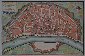
Cologne Ville Considerable Situee Sur le bord Occidentale du Rhein Capit. de l'Electorat de meme nom.
Erscheinungsdatum: 1705
Anbieter: Geographicus Rare Antique Maps, Brooklyn, NY, USA
Verbandsmitglied: ABAA ESA ILAB
Verkõuferbewertung 5 von 5 Sternen
Karte
Very good. Original platemark visible. Blank on verso. Minor overall toning. Size 9.5 x 14 Inches. This is a beautiful 1705 Nicholas de Fer map of the walled city of Cologne, Germany. Oriented with North to the right, this map identifies the location of the city on the banks of the Rhine River. Originally the capital city of the Roman province Germania Inferior, Cologne was established in 50 AD. The medieval city wall surrounding the city was built in 1180 and enclosed the Free Imperial City for 600 years. Of the original 12 city gates, only Eigelsteintorburg, Hahnentorburg, Severinstorburg and Ulrepforte remain to this day. The remains of Bayen, the medieval tower and the city wall at Gereonswall can also been seen today. This map identifies various streets, churches and other notes other topographical details throughout. This map created by Nicholas de Fer in 1705.
-
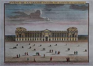
Veue de la grande fasade du Louvre, du c¶te d'Orient
Sprache: Deutsch
Erscheinungsdatum: 1700
Anbieter: Kunstantiquariat Andreas Senger, Hamburg, Deutschland
Verkõuferbewertung 4 von 5 Sternen
Kunst / Grafik / Poster
Kein Einband. Zustand: Sehr gut. Es handelt sich hierbei um einen seltenen, originalen, kolorierten Kupferstich des Palais du Louvre von de Fer aus dem Jahr 1700. *** Titel: Veue de la grande fasade du Louvre, du c¶te d'Orient *** Gebiet bzw. Ort: Palais du Louvre, Paris *** Kartograph: Nicholas de Fer (1647 - 1720) *** Jahr: um 1700 *** Gr÷▀e des Plattenbereichs: ca. 24 cm x 32 cm *** Technik: Kupferstich *** Zustand (Perfekt/ Sehr gut/ Gut/ Ordentlich/ Mõ▀ig/ Schlecht): In sehr gutem Erhaltungszustand *** Bemerkungen: Sehr seltene und Ansicht des Palais du Louvre mit Personenstaffage im Vordergrund. Ein dazugeh÷render, beschreibender Kupferstich liegt ebenfalls bei. Der Louvre-Palast (franz÷sisch Palais du Louvre, kurz Louvre) ist die fr³here Residenz der franz÷sischen K÷nige in Paris. Er bildete zusammen mit dem zerst÷rten Palais des Tuileries das Pariser Stadtschloss. Die Herkunft des Namens Louvre ist unklar; zahlreiche Deutungen konkurrieren miteinander. Der Louvre-Palast beherbergt heute gr÷▀tenteils das nach ihm benannte Musķe du Louvre, das zumeist einfach Louvre genannt wird. Mit etwa zehn Millionen Besuchern im Jahr 2012 ist es das meistbesuchte Museum der Welt. Daneben birgt der Nordfl³gel drei Museen (Musķe des Arts dķcoratifs, Musķe de la Mode et du Textile, Musķe de la Publicitķ) und der BibliothĶque des Arts dķcoratifs. (Wikipedia) *** English description: This a rare, original copper engraving, published by Nicholas de Fer (1647 - 1720) around 1700 in Paris. It shows the Palais du Louvre in Paris which was the former main part of the city palace of the French Kings. Today it contains the famous Louvre art museum. The engraving measures ca. 24 x 32 cm (platesize) and is in very good condition. Included is a further engraving which contains a description in French. - - - International buyers welcome. If you have any questions, please don't hesitate to ask. --- Auf Wunsch stellen wir Ihnen gerne ein kostenfreies Echtheitszertifikat aus --- If you wish, we will gladly provide a certificate of authenticity free of charge ---.
-
Cologne Ville Considerable Situee sur le bord Occidentale du Rhein Capit. de l'Electorat de meme nom. Par N. de Fer
Sprache: Deutsch
Erscheinungsdatum: 1702
Anbieter: Kunstantiquariat Andreas Senger, Hamburg, Deutschland
Verkõuferbewertung 4 von 5 Sternen
Kunst / Grafik / Poster
Kein Einband. Zustand: Sehr gut. Es handelt sich hierbei um einen originalen, kolorierten Kupferstichplan der Stadt K÷ln von Nicholas de Fer aus dem Jahr 1702. *** Titel: Cologne Ville Considerable Situee sur le bord Occidentale du Rhein Capit. de l'Electorat de meme nom. Par N. de Fer *** Gebiet bzw. Ort: K÷ln *** Kartograph: Nicholas de Fer (1647 - 1720) *** Jahr: 1702 *** Gr÷▀e des Abbildungsbereichs: 23 x 35 cm *** Technik: Kupferstich *** Zustand (Perfekt/ Sehr gut/ Gut/ Ordentlich/ Mõ▀ig/ Schlecht): In sehr gutem Erhaltungszustand *** Bemerkungen: Sch÷ner Plan von K÷ln aus der Vogelschau in dekorativem Kolorit. - - - International buyers welcome. If you have any questions, please don't hesitate to ask. --- Auf Wunsch stellen wir Ihnen gerne ein kostenfreies Echtheitszertifikat aus --- If you wish, we will gladly provide a certificate of authenticity free of charge ---.
-
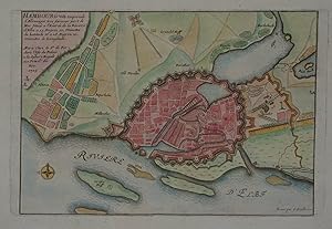
Hambourg Ville Imperiale d' Allemagne tres
Sprache: Deutsch
Erscheinungsdatum: 1705
Anbieter: Kunstantiquariat Andreas Senger, Hamburg, Deutschland
Verkõuferbewertung 4 von 5 Sternen
Kunst / Grafik / Poster
Kein Einband. Zustand: Gut. Es handelt sich hierbei um einen originalen, kolorierten Kupferstichplan der Stadt Hamburg von Nicholas de Fer aus dem Jahr 1705. *** Titel: Hambourg Ville Imperiale d' Allemagne tres *** Gebiet bzw. Ort: Hansestadt Hamburg +++ Kartograph: Nicholas de Fer (1647 - 1720) *** Jahr: 1705 *** Gr÷▀e des Abbildungsbereichs: 19 x 28 cm *** Technik: Kupferstich *** Zustand (Perfekt/ Sehr gut/ Gut/ Ordentlich/ Mõ▀ig/ Schlecht): In gutem Erhaltungszustand. Altersgemõ▀ leicht gebrõunt. *** Bemerkungen: Sch÷ner Plan von Hamburg in dekorativem Kolorit. Detaillierter Grundriss der Stadt Hamburg mit ihren Befestigungen, Hafenanlagen, der Binnen- und Au▀enalter. - - - International buyers welcome. If you have any questions, please don't hesitate to ask. --- Auf Wunsch stellen wir Ihnen gerne ein kostenfreies Echtheitszertifikat aus --- If you wish, we will gladly provide a certificate of authenticity free of charge ---.