

Gesamtpreis (1 Artikel Artikel):
Versandziel:

engraver taylor (48 Ergebnisse)
Direkt zu den wichtigsten Suchergebnissen
Suchfilter
Produktart
- Alle Product Types
- Bücher (3)
- Magazine & Zeitschriften (Keine weiteren Ergebnisse entsprechen dieser Verfeinerung)
- Comics (Keine weiteren Ergebnisse entsprechen dieser Verfeinerung)
- Noten (Keine weiteren Ergebnisse entsprechen dieser Verfeinerung)
- Kunst, Grafik & Poster (8)
- Fotografien (Keine weiteren Ergebnisse entsprechen dieser Verfeinerung)
- Karten (32)
- Manuskripte & Papierantiquitäten (5)
Zustand Mehr dazu
- Neu (Keine weiteren Ergebnisse entsprechen dieser Verfeinerung)
- Wie Neu, Sehr Gut oder Gut Bis Sehr Gut (Keine weiteren Ergebnisse entsprechen dieser Verfeinerung)
- Gut oder Befriedigend (13)
- Ausreichend oder Schlecht (Keine weiteren Ergebnisse entsprechen dieser Verfeinerung)
- Wie beschrieben (35)
Einband
- alle Einbände
- Hardcover (2)
- Softcover (Keine weiteren Ergebnisse entsprechen dieser Verfeinerung)
Weitere Eigenschaften
- Erstausgabe (Keine weiteren Ergebnisse entsprechen dieser Verfeinerung)
- Signiert (Keine weiteren Ergebnisse entsprechen dieser Verfeinerung)
- Schutzumschlag (Keine weiteren Ergebnisse entsprechen dieser Verfeinerung)
- Angebotsfoto (47)
Sprache (1)
Gratisversand
- Kostenloser Versand nach USA (Keine weiteren Ergebnisse entsprechen dieser Verfeinerung)
Land des Verkäufers
Verkäuferbewertung
-
The Road from Fochabers to Aviemore. [with] The Road from Nairn to Fort George. [and on verso] The Road from Inverness to Fort Augustus and Fort William and from Inverness to Glen Urquhart.
Verlag: London Published according to Act of Parliament 8th Feby., 1776
Anbieter: Robert Frew Ltd. ABA ILAB, London, Vereinigtes Königreich
Verbandsmitglied: ABA ILAB PBFA
Verkäuferbewertung 5 von 5 Sternen

Karte
EUR 60,45
EUR 11,74 Versand
Versand von Vereinigtes Königreich nach USAAnzahl: 1 verfügbar
In den Warenkorb47 x 18.5 cm and 45.6 x 19 cm. Uncoloured. Original copper engraved road maps printed recto and verso, each side with three columns. Browned. Plates 59 & 60 from "Taylor & Skinner's Survey Maps of the Roads of North Britain or Scotland".
-

The Match-Girl's Dream.
Verlag: London: The Girl's Own Paper, circa 1880s., 1880
Anbieter: Wittenborn Art Books, San Francisco, CA, USA
Verkäuferbewertung 5 von 5 Sternen
Kunst / Grafik / Poster
Zustand: Good. Wood engraving. 28.5 x 21.5 cm. (sheet). Very Good. Remains of masking tape showing through at top and bottom sheet edges.
-

"A Fireplace" to illustrate "Flower Decorations".
Verlag: London: The Girl's Own Paper, December 12., 1891
Anbieter: Wittenborn Art Books, San Francisco, CA, USA
Verkäuferbewertung 5 von 5 Sternen
Kunst / Grafik / Poster
Zustand: Good. Wood engraving. 22 x 21.5 cm. (sheet). Very Good. Masking tape remains showing through at top sheet edges. Text on the reverse.
-

A Christmas Ride, from "The Evangelist Monthly, A Church Magazine."
Verlag: London: Bemrose & Sons, circa 1893., 1893
Anbieter: Wittenborn Art Books, San Francisco, CA, USA
Verkäuferbewertung 5 von 5 Sternen
Kunst / Grafik / Poster
Zustand: Good. Wood engraving. 24.5 x 18.5 cm. (sheet). Very Good. Light toning along sheet edges.
-
THE PUBLIC EDIFICES OF THE BRITISH METROPOLIS with Historical And Descriptive Accounts of the Different Buildings
Verlag: C Taylor; Sherwood, Gilbert And Piper; Simpkin, Marshall and Co.; T Hughes; T Mason, London, 1825
Anbieter: Dodman Books, Morston, Vereinigtes Königreich
Verbandsmitglied: IOBA
Verkäuferbewertung 5 von 5 Sternen
EUR 362,70
EUR 15,26 Versand
Versand von Vereinigtes Königreich nach USAAnzahl: 1 verfügbar
In den WarenkorbHardcover. Zustand: Good. No Jacket. 2nd Edition. Splendid collection of 21 fine engravings of London buildings, with short accompanying descriptions. St Paul's, Westminster Abbey, 'Buckingham House', Horse Guards, Carlton Place, Pantheon, Bank of England and Westminster Bridge among the subjects. Some foxing and a little marking. Bound in half-leather with marbled paper boards, all heavily worn. Gilt titling to spine. Scarce. Folio. 20pp + plates.
-

THE PUBLIC EDIFICES OF THE BRITISH METROPOLIS; With Historical and Descriptive Accounts of the Different Buildings.
Verlag: Published by C. Taylor. Sherwood Gilbert and Piper; Simpkin Marshall; T. Hughes; and T. Mason, 1825
Anbieter: Francis Edwards ABA ILAB, Hay on Wye, Vereinigtes Königreich
Verbandsmitglied: ABA ILAB PBFA
Verkäuferbewertung 5 von 5 Sternen
EUR 398,97
EUR 25,82 Versand
Versand von Vereinigtes Königreich nach USAAnzahl: 1 verfügbar
In den Warenkorb[2nd Ed]. 4to. T.p. + [xxii]. letterpress. Hand cold. engraved frontis., 20 engraved plates. Minor sporadic browning, rebound in gilt filleted edged crushed morocco with marbled boards, gilt filleted raised bands with gilt lettering to spine. Scarce.Charles Taylor (17561823), engraver and biblical scholar, ODNB '. he was articled to his father as an engraver and is believed to have studied under Francesco Bartolozzi .' 'Most of the plates and text originally appeared in "The temple of taste," 1795-6, published in parts' V & A.Of our twenty one plates 5 are undated, 11 dated 1825, 1 dated 1794, 1 dated 1795 and three dated 1796. Paper guards to each plate, 1 leaf watermarked 1825.First published in the above format in 1820 by C. Taylor,., Neely and Jones, ., and Simpkin and Marshall, with 24 plates. US$442.
-
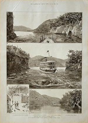
Sketches from Burmah: Up the Chindwin. By an Irrawaddy Flotilla Officer (Captain A.E. Rimmer, Steamer Pathein).
Verlag: Illustrated London News. October 16,1886., 1886
Anbieter: Asia Bookroom ANZAAB/ILAB, Canberra, ACT, Australien
Verkäuferbewertung 5 von 5 Sternen
Sheet from the Illustrated London News showing four engravings of scenes along the Chindwin. 1. The Hpai-yai Whirlpool, below Kalaymyo. 2. Shooting the Shoay-gyee Whirlpools. 3. The Stockade at Kendat. 4. The Military Camp at Mingin. There is half a column of text on the reverse of the sheet entitled from Sketches from Burmah.
-

H.M.S. Victory on Oct. 21, 1886, at Portsmouth. The present Lord Nelson distributing prizes to scholars of the the Portsmouth Church High Scholls.
Verlag: London: The Illustrated London News., 1886
Anbieter: Wittenborn Art Books, San Francisco, CA, USA
Verkäuferbewertung 5 von 5 Sternen
Manuskript / Papierantiquität
Zustand: Good. Hand-colored wood engraving. 41 x 30 cm (sheet). Text on verso. Very Good.
-

'The World went very well then.' by Walter Besant.
Verlag: London: The Illustrated London News., 1886
Anbieter: Wittenborn Art Books, San Francisco, CA, USA
Verkäuferbewertung 5 von 5 Sternen
Manuskript / Papierantiquität
Zustand: Good. Hand-colored wood engraving. 41 x 30 cm (sheet). Text on verso. Very Good.
-

'All Hands Man the Life-Boat!'.
Verlag: London: The Illustrated London News., 1882
Anbieter: Wittenborn Art Books, San Francisco, CA, USA
Verkäuferbewertung 5 von 5 Sternen
Manuskript / Papierantiquität
Zustand: Good. Hand-colored wood engraving. 41 x 30 cm (sheet). Text on verso. Very Good.
-

The Athenaeum, Drawing Room
Verlag: [London: British publisher, circa 1845]., 1845
Anbieter: Wittenborn Art Books, San Francisco, CA, USA
Verkäuferbewertung 5 von 5 Sternen
Kunst / Grafik / Poster
Zustand: Good. Engraving. 20 x 27 cm (sheet). Very Good, tape along sheet edges on verso.Provenance: From the collection of the late Frederick Ruffner, Jr., founder of Gale Research, Detroit.
-

Ready for the Naval Review.
Verlag: London: The Illustrated London News, Aug. 3., 1889
Anbieter: Wittenborn Art Books, San Francisco, CA, USA
Verkäuferbewertung 5 von 5 Sternen
Manuskript / Papierantiquität
Zustand: Good. Wood engraving. 28.5 x 40 cm (sheet). Very Good, light toning and tears along sheet edges (none extending into image).
-

Le Joueur de Cornemuse. (B&W engraving).
Verlag: [Paris]: [18th Century French Publisher], [1700s]., 1700
Anbieter: Wittenborn Art Books, San Francisco, CA, USA
Verkäuferbewertung 5 von 5 Sternen
Kunst / Grafik / Poster
Zustand: Good. Original B&W gravure. 4.5 x 4.5 inches. Very Good. Light matting.
-

Le Joueur de Cornemuse. (B&W engraving).
Verlag: [Paris]: [19th Century French Publisher], [1800s]., 1800
Anbieter: Wittenborn Art Books, San Francisco, CA, USA
Verkäuferbewertung 5 von 5 Sternen
Kunst / Grafik / Poster
Zustand: Good. Original B&W gravure. 4.5 x 4.5 inches. Very Good. Light matting.
-
Roads From Edinburgh to Moffat & Dumfries by Peebles, & also by Linton, Miles measured from the Chapel of Ease, Edinburgh on the Peebles Rd. 3/4 Mile distant from the Cross. [Title repeated on verso with the addition of Lochmaben].
Verlag: London 1776, 1775
Anbieter: Robert Frew Ltd. ABA ILAB, London, Vereinigtes Königreich
Verbandsmitglied: ABA ILAB PBFA
Verkäuferbewertung 5 von 5 Sternen
Karte
EUR 90,68
EUR 11,74 Versand
Versand von Vereinigtes Königreich nach USAAnzahl: 1 verfügbar
In den Warenkorb45.2 x 18.7 and 44.7 x 17.8 cm. Uncoloured. Original copper engraved road map, printed recto and verso, each side with three columns. Three horizontal ceases across sheet. Light browning overall.
-
The Road from Glasgow to Ayr, & from Glasgow & Kilmarnock to Sanquehar & Dumfries. [and on verso] The Road from Dumfries to Monyhive.
Verlag: London Publish'd according to the Act of Parliament. 8th Feby., 1776
Anbieter: Robert Frew Ltd. ABA ILAB, London, Vereinigtes Königreich
Verbandsmitglied: ABA ILAB PBFA
Verkäuferbewertung 5 von 5 Sternen
Karte
EUR 90,68
EUR 11,74 Versand
Versand von Vereinigtes Königreich nach USAAnzahl: 1 verfügbar
In den Warenkorb46 x 18.3 cm and 45.5 x 18.3 cm. Uncoloured. Original copper engraved road maps printed recto and verso, each side with three columns.The first map continued onto the first two columns on verso. Plates 41 & 42 from "Taylor & Skinner's Survey Maps of the Roads of North Britain or Scotland".
-
The Road continued from Aberdeen By Old Meldrum, to Banff. [with] The Road from Banff to Inverness.
Verlag: London Publish'd according to the Act of Parliament. January 23 d., 1776
Anbieter: Robert Frew Ltd. ABA ILAB, London, Vereinigtes Königreich
Verbandsmitglied: ABA ILAB PBFA
Verkäuferbewertung 5 von 5 Sternen
Karte
EUR 90,68
EUR 11,74 Versand
Versand von Vereinigtes Königreich nach USAAnzahl: 1 verfügbar
In den Warenkorb45.5 x 19 cm and 46.8 x 19.1 cm. Uncoloured. Original copper engraved road maps printed recto and verso. The map on recto showing the road from Stonehaven to Banff. The map on verso showing the road from Banff to Inverness over four columns. Plates 31 & 32 from "Taylor & Skinner's Survey Maps of the Roads of North Britain or Scotland".
-
The Road From Edinburgh, to Wigtoun and Whitehorn by Biggar Leadhills and New Galloway. [with on verso] The Road from Edinburgh to Lanark and Ayr by Douglass and Cumnock. Measured from the West Port 1775.
Verlag: London Publish'd according to the Act of Parliament. December 16th 1776, 1775
Anbieter: Robert Frew Ltd. ABA ILAB, London, Vereinigtes Königreich
Verbandsmitglied: ABA ILAB PBFA
Verkäuferbewertung 5 von 5 Sternen
Karte
EUR 90,68
EUR 11,74 Versand
Versand von Vereinigtes Königreich nach USAAnzahl: 1 verfügbar
In den Warenkorb45.8 x 18.8 cm and 45.8 x 17.8 cm. Uncoloured. Original copper engraved road maps printed recto and verso, each side with three columns. The first map continuing on to the first two columns on verso, only the first part of second map (Edinburgh to Kearns Castle) is included here. Plates 7 & 8 from "Taylor & Skinner's Survey Maps of the Roads of North Britain or Scotland".
-
The Road from Glasgow to Paisley, Bieth & Kilwhinning. [with] The Road from Lanark to Hamilton. [with] The Road from Lanark to Glasgow. [and on verso] The Road from Stirling to Glasgow. [with] The Road from Stirling to Dumbarton.
Verlag: London Publish'd according to the Act of Parliament. 8th Feb., 1776
Anbieter: Robert Frew Ltd. ABA ILAB, London, Vereinigtes Königreich
Verbandsmitglied: ABA ILAB PBFA
Verkäuferbewertung 5 von 5 Sternen
Karte
EUR 90,68
EUR 11,74 Versand
Versand von Vereinigtes Königreich nach USAAnzahl: 1 verfügbar
In den Warenkorb46.3 x 18.3 cm and 46 x 18 cm. Uncoloured. Original copper engraved road maps printed recto and verso, each side with three columns Plates 47 & 48 from "Taylor & Skinner's Survey Maps of the Roads of North Britain or Scotland".
-
The Stirling Road Continued from Dalnacardoch. to Fort Augustus and on toward Bernero. [with, on verso] The Road from Dunkeld, to Kenmore and Killin.
Verlag: London Publish'd according to the Act of Parliament. January 23 d., 1776
Anbieter: Robert Frew Ltd. ABA ILAB, London, Vereinigtes Königreich
Verbandsmitglied: ABA ILAB PBFA
Verkäuferbewertung 5 von 5 Sternen
Karte
EUR 90,68
EUR 11,74 Versand
Versand von Vereinigtes Königreich nach USAAnzahl: 1 verfügbar
In den Warenkorb46.5 x 18.6 cm and 46.7 x 18.5 cm. Uncoloured. Original copper engraved road maps printed recto and verso, each side with three columns. The map on recto showing the road from Dalnacardoch to Loch Cluanie, continued on the first colum on verso up to Glenelg. The map on the remaining two columns of verso showing the road from Dunkeld to Killin. Engraved by Thos. Bowen. Plates 19 & 20 from "Taylor & Skinner's Survey Maps of the Roads of North Britain or Scotland".
-
The Road from Glasgow to Irvine. [with] The Road from Maybole to Girvan. [with] the Road from Ayr to Machlin. [and on verso] The Road from Greenock to Irvine and Ayr. [with] The Road from Dumbarton to Row Kirk & Portencaple.
Verlag: London Publish'd according to the Act of Parliament. 8th Feb., 1776
Anbieter: Robert Frew Ltd. ABA ILAB, London, Vereinigtes Königreich
Verbandsmitglied: ABA ILAB PBFA
Verkäuferbewertung 5 von 5 Sternen
Karte
EUR 90,68
EUR 11,74 Versand
Versand von Vereinigtes Königreich nach USAAnzahl: 1 verfügbar
In den Warenkorb45.5 x 18.8 cm and 44.8 x 18.3 cm. Uncoloured. Original copper engraved road maps printed recto and verso, each side with three columns Plates 45 & 46 from "Taylor & Skinner's Survey Maps of the Roads of North Britain or Scotland".
-
The Road from Edinburgh, continued to Ayr by Hamilton. [with on verso] The Road from Edinr. to Glasgow & Greenock & to Dumbarton & Inverary, Continued.
Verlag: London Publish'd according to the Act of Parliament. 29 th December, 1775
Anbieter: Robert Frew Ltd. ABA ILAB, London, Vereinigtes Königreich
Verbandsmitglied: ABA ILAB PBFA
Verkäuferbewertung 5 von 5 Sternen
Karte
EUR 90,68
EUR 11,74 Versand
Versand von Vereinigtes Königreich nach USAAnzahl: 1 verfügbar
In den Warenkorb46.5 x 18.7 cm and 44.6 x 19 cm. Uncoloured. Original copper engraved road maps printed recto and verso, each side with three columns. The map on recto showing the road from Whitburn to Ayr. The map on the verso showing the road from Glasgow to Port Glasgow and Dumbarton to Tarbet. Engraved by S.Pyle. Plates 11 & 12 from "Taylor & Skinner's Survey Maps of the Roads of North Britain or Scotland".
-
The Road from Edinburgh to Dundee, Aberbrotbick, Montrose, Inverurie & Stonehaven. [with on verso]The Road from Edinburgh to Montrose & Stonehaven, Continued. [and] The Road from Pathead to Crail. [and] The Road from Edinburgh to Cupar by Kennoway.
Verlag: London Publish'd according to the Act of Parliament. January 23 d., 1776
Anbieter: Robert Frew Ltd. ABA ILAB, London, Vereinigtes Königreich
Verbandsmitglied: ABA ILAB PBFA
Verkäuferbewertung 5 von 5 Sternen
Karte
EUR 90,68
EUR 11,74 Versand
Versand von Vereinigtes Königreich nach USAAnzahl: 1 verfügbar
In den Warenkorb45.5 x 19 cm and 45.9 x 18.6 cm. Uncoloured. Original copper engraved road maps printed recto and verso. The first map showing the road from Edinburgh to Inverurie via Arbroath, continued onto the first one and a half columns on verso. The remaining columns on verso show the road from Dysart to Crail and the road leading to Cupar. Plates 33 & 34 from "Taylor & Skinner's Survey Maps of the Roads of North Britain or Scotland".
-
The Road From Edinburgh, to Wigtoun and Whitehorn by Biggar Leadhills and New Galloway. [with continuation on verso plus] The Road from Edinburgh to Lanark and Ayr by Douglass and Cumnock. Measured from the West Port 1775.
Verlag: London 1776, 1775
Anbieter: Robert Frew Ltd. ABA ILAB, London, Vereinigtes Königreich
Verbandsmitglied: ABA ILAB PBFA
Verkäuferbewertung 5 von 5 Sternen
Karte
EUR 90,68
EUR 11,74 Versand
Versand von Vereinigtes Königreich nach USAAnzahl: 1 verfügbar
In den Warenkorb45.8 x 18.7 cm and 45.6 x 18.3 cm. Uncoloured. Original copper engraved road maps printed recto and verso, each side with three columns. The first map continuing on to the first two columns on verso, only the first part of second map (Edinburgh to Kearns Castle) is included here. Some light offsetting, otherwise in very good condition. Plates 7 & 8 from "Taylor & Skinner's Survey Maps of the Roads of North Britain or Scotland".
-
The Road from Edinburgh to Dundee, Aberbrotbick, Montrose, Inverurie & Stonehaven. [with on verso]The Road from Edinburgh to Montrose & Stonehaven, Continued. [and] The Road from Pathead to Crail. [and] The Road from Edinburgh to Cupar by Kennoway.
Verlag: London:, 1776
Anbieter: Robert Frew Ltd. ABA ILAB, London, Vereinigtes Königreich
Verbandsmitglied: ABA ILAB PBFA
Verkäuferbewertung 5 von 5 Sternen
Karte
EUR 90,68
EUR 11,74 Versand
Versand von Vereinigtes Königreich nach USAAnzahl: 1 verfügbar
In den Warenkorb45.5 x 19 cm and 45.9 x 18.6 cm. Uncoloured. Original copper engraved road maps printed recto and verso. The first map showing the road from Edinburgh to Inverurie via Arbroath, continued onto the first one and a half columns on verso. The remaining columns on verso show the road from Dysart to Crail and the road leading to Cupar. A few small light stains, some light offsetting, otherwise in very good condition. Plates 33 & 34 from "Taylor & Skinner's Survey Maps of the Roads of North Britain or Scotland".
-
Road from Wick to Thurso. [with] Road from Wick to Dungsby Head. [with] Road from Thurso to Dungsby Head. [with on verso] The Road from Perth to Fort George.
Verlag: London:, 1776
Anbieter: Robert Frew Ltd. ABA ILAB, London, Vereinigtes Königreich
Verbandsmitglied: ABA ILAB PBFA
Verkäuferbewertung 5 von 5 Sternen
Karte
EUR 90,68
EUR 11,74 Versand
Versand von Vereinigtes Königreich nach USAAnzahl: 1 verfügbar
In den Warenkorb46.8 x 18.8 cm and 46.2 x 18.8 cm. Uncoloured. Original copper engraved road maps printed recto and verso, each side with three columns. The maps on recto showing the roads to John o'Groats from Wick and Thurso. The map on verso showing the road from Perth to Fort George. Small spot to left side of map verso. Some light offsetting, otherwise in very good condition. Plates 25 & 26 from "Taylor & Skinner's Survey Maps of the Roads of North Britain or Scotland".
-
The Road from Edinburgh, by Douglas to Ayr and Stranrawer Continued [with on verso] The Road from Edinburgh, to Ayr by Hamilton, and to Glasgow, Dumbarton & Inveraray.
Verlag: London 1776, 1775
Anbieter: Robert Frew Ltd. ABA ILAB, London, Vereinigtes Königreich
Verbandsmitglied: ABA ILAB PBFA
Verkäuferbewertung 5 von 5 Sternen
Karte
EUR 90,68
EUR 11,74 Versand
Versand von Vereinigtes Königreich nach USAAnzahl: 1 verfügbar
In den Warenkorb47 x 19.3 cm and 46 x 18.7 cm. Uncoloured. Original copper engraved road maps printed recto and verso, each side with three columns. The map on recto showing the road from Carnworth to Ayr, continued on the first two columns of the verso showing the road from Maybole to Stranraer. The third column on the verso showing the road from Edinburgh to Livingston. Some light offsetting, otherwise in very good condition. Plates 9 & 10 from "Taylor & Skinner's Survey Maps of the Roads of North Britain or Scotland".
-
The Road from Glasgow to Ayr, & from Glasgow & Kilmarnock to Sanquehar & Dumfries. [and on verso] The Road from Dumfries to Monyhive.
Verlag: London:, 1776
Anbieter: Robert Frew Ltd. ABA ILAB, London, Vereinigtes Königreich
Verbandsmitglied: ABA ILAB PBFA
Verkäuferbewertung 5 von 5 Sternen
Karte
EUR 90,68
EUR 11,74 Versand
Versand von Vereinigtes Königreich nach USAAnzahl: 1 verfügbar
In den Warenkorb46 x 18.3 cm and 45.5 x 18.3 cm. Uncoloured. Original copper engraved road maps printed recto and verso, each side with three columns.The first map continued onto the first two columns on verso. Some light offsetting, otherwise in very good condition. Plates 41 & 42 from "Taylor & Skinner's Survey Maps of the Roads of North Britain or Scotland".
-
The Road from Glasgow to Irvine. [with] The Road from Maybole to Girvan. [with] the Road from Ayr to Machlin. [and on verso] The Road from Greenock to Irvine and Ayr. [with] The Road from Dumbarton to Row Kirk & Portencaple.
Verlag: London:, 1776
Anbieter: Robert Frew Ltd. ABA ILAB, London, Vereinigtes Königreich
Verbandsmitglied: ABA ILAB PBFA
Verkäuferbewertung 5 von 5 Sternen
Karte
EUR 90,68
EUR 11,74 Versand
Versand von Vereinigtes Königreich nach USAAnzahl: 1 verfügbar
In den Warenkorb45.5 x 18.8 cm and 44.8 x 18.3 cm. Uncoloured. Original copper engraved road maps printed recto and verso, each side with three columns Some light offsetting, small stain towards upper margin (both sides), otherwise in very good condition. Plates 45 & 46 from "Taylor & Skinner's Survey Maps of the Roads of North Britain or Scotland".
-
The Road from Braemar to Fort George. [with] The Road from Perth to Brechine.
Verlag: London:, 1776
Anbieter: Robert Frew Ltd. ABA ILAB, London, Vereinigtes Königreich
Verbandsmitglied: ABA ILAB PBFA
Verkäuferbewertung 5 von 5 Sternen
Karte
EUR 90,68
EUR 11,74 Versand
Versand von Vereinigtes Königreich nach USAAnzahl: 1 verfügbar
In den Warenkorb47.2 x 18.5 and 47.3 x 19 cm. Uncoloured. Original copper engraved road maps printed recto and verso, the former with three columns and the latter with two. Small spot to left side of map verso. Some light offsetting and soiling, upper right margin when viewed from recto chipped with very slight loss to border. Plates 27 & 28 from "Taylor & Skinner's Survey Maps of the Roads of North Britain or Scotland".
![Bild des Verkäufers für The Road from Fochabers to Aviemore. [with] The Road from Nairn to Fort George. [and on verso] The Road from Inverness to Fort Augustus and Fort William and from Inverness to Glen Urquhart. zum Verkauf von Robert Frew Ltd. ABA ILAB](https://pictures.abebooks.com/inventory/md/md30219631201.jpg)


![Bild des Verkäufers für Roads From Edinburgh to Moffat & Dumfries by Peebles, & also by Linton, Miles measured from the Chapel of Ease, Edinburgh on the Peebles Rd. 3/4 Mile distant from the Cross. [Title repeated on verso with the addition of Lochmaben]. zum Verkauf von Robert Frew Ltd. ABA ILAB](https://pictures.abebooks.com/inventory/md/md30861963967.jpg)
![Bild des Verkäufers für The Road from Glasgow to Ayr, & from Glasgow & Kilmarnock to Sanquehar & Dumfries. [and on verso] The Road from Dumfries to Monyhive. zum Verkauf von Robert Frew Ltd. ABA ILAB](https://pictures.abebooks.com/inventory/md/md30219629331.jpg)
![Bild des Verkäufers für The Road continued from Aberdeen By Old Meldrum, to Banff. [with] The Road from Banff to Inverness. zum Verkauf von Robert Frew Ltd. ABA ILAB](https://pictures.abebooks.com/inventory/md/md30219627341.jpg)
![Bild des Verkäufers für The Road From Edinburgh, to Wigtoun and Whitehorn by Biggar Leadhills and New Galloway. [with on verso] The Road from Edinburgh to Lanark and Ayr by Douglass and Cumnock. Measured from the West Port 1775. zum Verkauf von Robert Frew Ltd. ABA ILAB](https://pictures.abebooks.com/inventory/md/md30219627339.jpg)
![Bild des Verkäufers für The Road from Glasgow to Paisley, Bieth & Kilwhinning. [with] The Road from Lanark to Hamilton. [with] The Road from Lanark to Glasgow. [and on verso] The Road from Stirling to Glasgow. [with] The Road from Stirling to Dumbarton. zum Verkauf von Robert Frew Ltd. ABA ILAB](https://pictures.abebooks.com/inventory/md/md30219631199.jpg)
![Bild des Verkäufers für The Stirling Road Continued from Dalnacardoch. to Fort Augustus and on toward Bernero. [with, on verso] The Road from Dunkeld, to Kenmore and Killin. zum Verkauf von Robert Frew Ltd. ABA ILAB](https://pictures.abebooks.com/inventory/md/md30219628342.jpg)
![Bild des Verkäufers für The Road from Glasgow to Irvine. [with] The Road from Maybole to Girvan. [with] the Road from Ayr to Machlin. [and on verso] The Road from Greenock to Irvine and Ayr. [with] The Road from Dumbarton to Row Kirk & Portencaple. zum Verkauf von Robert Frew Ltd. ABA ILAB](https://pictures.abebooks.com/inventory/md/md30219622560.jpg)
![Bild des Verkäufers für The Road from Edinburgh, continued to Ayr by Hamilton. [with on verso] The Road from Edinr. to Glasgow & Greenock & to Dumbarton & Inverary, Continued. zum Verkauf von Robert Frew Ltd. ABA ILAB](https://pictures.abebooks.com/inventory/md/md30219625343.jpg)
![Bild des Verkäufers für The Road from Edinburgh to Dundee, Aberbrotbick, Montrose, Inverurie & Stonehaven. [with on verso]The Road from Edinburgh to Montrose & Stonehaven, Continued. [and] The Road from Pathead to Crail. [and] The Road from Edinburgh to Cupar by Kennoway. zum Verkauf von Robert Frew Ltd. ABA ILAB](https://pictures.abebooks.com/inventory/md/md22397056643.jpg)
![Bild des Verkäufers für The Road From Edinburgh, to Wigtoun and Whitehorn by Biggar Leadhills and New Galloway. [with continuation on verso plus] The Road from Edinburgh to Lanark and Ayr by Douglass and Cumnock. Measured from the West Port 1775. zum Verkauf von Robert Frew Ltd. ABA ILAB](https://pictures.abebooks.com/inventory/md/md17237131001.jpg)
![Bild des Verkäufers für The Road from Edinburgh to Dundee, Aberbrotbick, Montrose, Inverurie & Stonehaven. [with on verso]The Road from Edinburgh to Montrose & Stonehaven, Continued. [and] The Road from Pathead to Crail. [and] The Road from Edinburgh to Cupar by Kennoway. zum Verkauf von Robert Frew Ltd. ABA ILAB](https://pictures.abebooks.com/inventory/md/md17237131011.jpg)
![Bild des Verkäufers für Road from Wick to Thurso. [with] Road from Wick to Dungsby Head. [with] Road from Thurso to Dungsby Head. [with on verso] The Road from Perth to Fort George. zum Verkauf von Robert Frew Ltd. ABA ILAB](https://pictures.abebooks.com/inventory/md/md17237131007.jpg)
![Bild des Verkäufers für The Road from Edinburgh, by Douglas to Ayr and Stranrawer Continued [with on verso] The Road from Edinburgh, to Ayr by Hamilton, and to Glasgow, Dumbarton & Inveraray. zum Verkauf von Robert Frew Ltd. ABA ILAB](https://pictures.abebooks.com/inventory/md/md17237131002.jpg)
![Bild des Verkäufers für The Road from Glasgow to Ayr, & from Glasgow & Kilmarnock to Sanquehar & Dumfries. [and on verso] The Road from Dumfries to Monyhive. zum Verkauf von Robert Frew Ltd. ABA ILAB](https://pictures.abebooks.com/inventory/md/md17237131013.jpg)
![Bild des Verkäufers für The Road from Glasgow to Irvine. [with] The Road from Maybole to Girvan. [with] the Road from Ayr to Machlin. [and on verso] The Road from Greenock to Irvine and Ayr. [with] The Road from Dumbarton to Row Kirk & Portencaple. zum Verkauf von Robert Frew Ltd. ABA ILAB](https://pictures.abebooks.com/inventory/md/md17237131015.jpg)
![Bild des Verkäufers für The Road from Braemar to Fort George. [with] The Road from Perth to Brechine. zum Verkauf von Robert Frew Ltd. ABA ILAB](https://pictures.abebooks.com/inventory/md/md17237131008.jpg)