Gesamtpreis (1 Artikel Artikel):
Versandziel:

emanuel bowen (218 Ergebnisse)
Direkt zu den wichtigsten Suchergebnissen
Suchfilter
Produktart
- Alle Product Types
- Bücher (151)
- Magazine & Zeitschriften (Keine weiteren Ergebnisse entsprechen dieser Verfeinerung)
- Comics (Keine weiteren Ergebnisse entsprechen dieser Verfeinerung)
- Noten (Keine weiteren Ergebnisse entsprechen dieser Verfeinerung)
- Kunst, Grafik & Poster (3)
- Fotografien (Keine weiteren Ergebnisse entsprechen dieser Verfeinerung)
- Karten (63)
- Manuskripte & Papierantiquitäten (1)
Zustand Mehr dazu
Weitere Eigenschaften
Sprache (3)
Gratisversand
Land des Verkäufers
Verkäuferbewertung
-
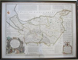
Britannia Depicta Or Ogilby Improved Road Atlas Of England And Wales ( 1720 )
Verlag: Frank Graham, Newcastle, 1970
ISBN 10: 0900409398 ISBN 13: 9780900409394
Anbieter: Alexander Books (ABAC/ILAB), Ancaster, ON, Kanada
Verkäuferbewertung 5 von 5 Sternen

Hardcover. Zustand: Fine. Zustand des Schutzumschlags: Good. Facsimile. 273 Pages Illus. Dust Jacket Shows Wear From Handling With Several Tears.
-
Circa 1720 Original MAP of FLINTSHIRE from the Britannia Depicta Atlas by the Cartographers John Owen and Emanuel Bowen
Sprache: Englisch
Verlag: John Owen and Emanuel Bowen, London, 1720
Anbieter: Andrew Cox PBFA, Shropshire, Vereinigtes Königreich
Verbandsmitglied: PBFA
Verkäuferbewertung 5 von 5 Sternen
Karte
EUR 18,90
EUR 22,36 Versand
Versand von Vereinigtes Königreich nach USAAnzahl: 1 verfügbar
In den WarenkorbNo Binding. Zustand: Good. Dating to circa 1720 this is a nice hand coloured antique map of Flintshire by John Owen and Emanuel Bowen, the map comes from their Atlas Britannia Depicta, and is double sided with a road map on the reverse showing the road from Shrewsbury to Wrexham. The map measures 7.5 inches by 5.25 inches approx., noticeable browning to the reserve side else in nice condition. This is a lighter item, overseas shipping costs will be reduced accordingly at checkout.
-

Colored Antique Maps: "Cumberland" And "Kendal" , From Atlas Britannia Depicta, 1720
Sprache: Englisch
Verlag: Thomas Bowles, London, 1720
Anbieter: Arroyo Seco Books, Pasadena, Member IOBA, Pasadena, CA, USA
Verbandsmitglied: IOBA
Verkäuferbewertung 5 von 5 Sternen
Karte Erstausgabe
No Binding. Zustand: Fine. 1st Edition. Maps From "Britannia Depicta", Circa 1720. Nice Antique Coloring. Double Glass And Frame, Maps Are On Two Sides Of Single Sheet, Frame On One Side Only. Maps Fine, Slight Wear To Frame. Shipping At Additional Cost Above Basic Charge.D.
-

Colored Antique Framed Maps: "Warwick" And "Glocester" (Gloucester) , From Atlas Britannia Depicta, 1720
Sprache: Englisch
Verlag: Thomas Bowles, London, 1720
Anbieter: Arroyo Seco Books, Pasadena, Member IOBA, Pasadena, CA, USA
Verbandsmitglied: IOBA
Verkäuferbewertung 5 von 5 Sternen
Karte Erstausgabe
No Binding. Zustand: Fine. 1st Edition. Maps #183 And 184 From "Britannia Depicta", Circa 1720. Nice Antique Coloring. Double Glass And Frame, Maps Are On Two Sides Of Single Sheet, Frame On One Side Only. Maps Fine, Slight Wear To Frame. Shipping At Additional Cost Above Basic Charge.
-

Britannia depicta, or, Ogilby improved road atlas of England and Wales 1731
Anbieter: WeBuyBooks, Rossendale, LANCS, Vereinigtes Königreich
Verkäuferbewertung 5 von 5 Sternen
EUR 64,74
EUR 9,12 Versand
Versand von Vereinigtes Königreich nach USAAnzahl: 1 verfügbar
In den WarenkorbZustand: Good. Most items will be dispatched the same or the next working day. A copy that has been read but remains in clean condition. All of the pages are intact and the cover is intact and the spine may show signs of wear. The book may have minor markings which are not specifically mentioned.
-

A Complete Atlas, or Distinct View of the Known World; Exhibited in Sixty-Eight Maps : . by Emanuel Bowen, .
Sprache: Englisch
Verlag: Gale Ecco, Print Editions Jun 2010, 2010
ISBN 10: 1170804802 ISBN 13: 9781170804803
Anbieter: AHA-BUCH GmbH, Einbeck, Deutschland
Verkäuferbewertung 5 von 5 Sternen
Taschenbuch. Zustand: Neu. Neuware.
-
![Beispielbild für Britannia Depicta or Ogilby Improv'd : Being a Correct Coppy [sic] of Mr Ogilby's Actual Survey of all ye Direct & Principal Cross Roads in England and Wales: Wherein are Exactly Delineated & Engraven, The Fourth Ed zum Verkauf von AHA-BUCH GmbH](https://pictures.abebooks.com/isbn/9781385814512-de-300.jpg)
Britannia Depicta or Ogilby Improv'd : Being a Correct Coppy [sic] of Mr Ogilby's Actual Survey of all ye Direct & Principal Cross Roads in England and Wales: Wherein are Exactly Delineated & Engraven, The Fourth Ed
Sprache: Englisch
Verlag: Gale Ecco, Print Editions Apr 2018, 2018
ISBN 10: 1385814519 ISBN 13: 9781385814512
Anbieter: AHA-BUCH GmbH, Einbeck, Deutschland
Verkäuferbewertung 5 von 5 Sternen
Buch. Zustand: Neu. Neuware.
-
Map of Merionethshire.
Verlag: 1720 or later. 7.5in x 5in., 1720
Anbieter: R.G. Watkins Books and Prints, Ilminster, SOMER, Vereinigtes Königreich
Verkäuferbewertung 5 von 5 Sternen
EUR 17,72
EUR 32,11 Versand
Versand von Vereinigtes Königreich nach USAAnzahl: 1 verfügbar
In den WarenkorbEngraved County Map, above map, decorative cartouche with title "Road from London to Montgomery", on reverse, road map from Worcester to Campden, from "Britannia Depicta", Sheet 109/110, very good condition, some browning in border,
-
Map of Bedfordshire.
Verlag: 1720 or later. 7.5in x 5in., 1720
Anbieter: R.G. Watkins Books and Prints, Ilminster, SOMER, Vereinigtes Königreich
Verkäuferbewertung 5 von 5 Sternen
EUR 17,72
EUR 32,11 Versand
Versand von Vereinigtes Königreich nach USAAnzahl: 1 verfügbar
In den WarenkorbEngraved County Map, above map, decorative cartouche with title "Road from London to Oakham", on reverse, road map from Thetford to Norwich, from "Britannia Depicta", Sheet 117/118,
-
Map of Nottinghamshire.
Verlag: 1720 or later. 7.5in x 5in., 1720
Anbieter: R.G. Watkins Books and Prints, Ilminster, SOMER, Vereinigtes Königreich
Verkäuferbewertung 5 von 5 Sternen
EUR 17,72
EUR 32,11 Versand
Versand von Vereinigtes Königreich nach USAAnzahl: 1 verfügbar
In den WarenkorbEngraved County Map, above map, decorative cartouche with title "Road from London to Barwick", on reverse, road map from London to Ware, from "Britannia Depicta", Sheet 11/12, some marking,
-
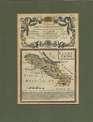
Map of Flintshire.
Verlag: 1720 or later. 7.5in x 5in., 1720
Anbieter: R.G. Watkins Books and Prints, Ilminster, SOMER, Vereinigtes Königreich
Verkäuferbewertung 5 von 5 Sternen
EUR 17,72
EUR 32,11 Versand
Versand von Vereinigtes Königreich nach USAAnzahl: 1 verfügbar
In den WarenkorbEngraved County Map, with later hand-colouring; above map, decorative cartouche with title "Road from Shrewsbury to Holywell", on reverse, road map from Shrewsbury to Wrexham, from "Britannia Depicta", Sheet 265/266, very good condition,
-
Map of Huntingdonshire.
Verlag: 1720 or later. 7.5in x 5in., 1720
Anbieter: R.G. Watkins Books and Prints, Ilminster, SOMER, Vereinigtes Königreich
Verkäuferbewertung 5 von 5 Sternen
EUR 17,72
EUR 32,11 Versand
Versand von Vereinigtes Königreich nach USAAnzahl: 1 verfügbar
In den WarenkorbEngraved County Map, above map, decorative cartouche with title "Road from Huntingdon to Ipswich", on reverse, road map from Huntingdon to Soham, from "Britannia Depicta", Sheet 191/192,
-
Map of Westmorland.
Verlag: 1720 or later. 7.5in x 5in., 1720
Anbieter: R.G. Watkins Books and Prints, Ilminster, SOMER, Vereinigtes Königreich
Verkäuferbewertung 5 von 5 Sternen
EUR 17,72
EUR 32,11 Versand
Versand von Vereinigtes Königreich nach USAAnzahl: 1 verfügbar
In den WarenkorbEngraved County Map, above map, decorative cartouche with title "Road from York to Whitby", on reverse, road map from York to Pickering, from "Britannia Depicta", Sheet 271/272,
-
Map of Denbighshire.
Verlag: 1720 or later. 7.5in x 5in., 1720
Anbieter: R.G. Watkins Books and Prints, Ilminster, SOMER, Vereinigtes Königreich
Verkäuferbewertung 5 von 5 Sternen
Karte
EUR 17,72
EUR 32,11 Versand
Versand von Vereinigtes Königreich nach USAAnzahl: 1 verfügbar
In den WarenkorbNo Binding. Zustand: Very good. No Jacket. Engraved County Map, above map, decorative cartouche with title "Road from Gloucester to Coventry", on reverse, road map from St Ives to Truro, from "Britannia Depicta", Sheet 181/182, very good condition, some browning in border,
-
Map of Monmouthshire.
Verlag: 1720 or later. 7.5in x 5in., 1720
Anbieter: R.G. Watkins Books and Prints, Ilminster, SOMER, Vereinigtes Königreich
Verkäuferbewertung 5 von 5 Sternen
EUR 17,72
EUR 32,11 Versand
Versand von Vereinigtes Königreich nach USAAnzahl: 1 verfügbar
In den WarenkorbEngraved County Map, above map, decorative cartouche with title "Road from Monmouth to Lanbeder", on reverse, road map from Monmouth to Abergaveny, from "Britannia Depicta", Sheet 203/204, faint stain left bottom corner,
-
1720 BRITANNIA DEPICTA or Ogilby improv'd; : being a correct coppy of Mr: Ogilby's Actual survey of all ye direct & principal cross roads in England and Wales:
Sprache: Englisch
Verlag: Published by Printed for, & sold by Tho: Bowles print & map seller, London, London, 1720
Anbieter: Andrew Cox PBFA, Shropshire, Vereinigtes Königreich
Verbandsmitglied: PBFA
Verkäuferbewertung 5 von 5 Sternen
Erstausgabe
EUR 2.303,30
EUR 22,36 Versand
Versand von Vereinigtes Königreich nach USAAnzahl: 1 verfügbar
In den WarenkorbFull-Leather. Zustand: Good. 1st Edition. BRITANNIA DEPICTA or Ogilby improv'd; : being a correct coppy of Mr: Ogilby's Actual survey of all ye direct & principal cross roads in England and Wales: wherein are exactly delineated & engraven, all ye cities, towns, villages, churches, seats &c. scituate on or near the roads, with their respective distances in measured and computed miles. And to render this - work universally usefull & agreeable, (beyond any of it's [sic] kind) are added in a clear & most compendious method 1, a full & particular description & account of all the cities, borough-towns, towns-corporate &c. their arms, antiquity, charters, privileges, trade, rarities, &c. with suitable remarks on all places of note drawn from the best historians and antiquaries - By Ino. Owen of the Midd: Temple gent. 2, The arms of the peers of this realm who derive their titles from places lying on, or near the roads 3, The arms of all ye bishopricks & deanaries, their foundation, extent, yearly-value, number of parishes &c. 4, The arms, & a succinct account of both universities & their respective colleges, their foundations fellowships &c. Lastly particular & correct maps - of all ye counties of South Britain; with a - summary description of each county, it's [sic] circumference, number of acres, boro' & market towns & parishes, air, soil, com[m]odities, manufactures & what each pays in ye 2. sh Aid &c. The whole for its compendious variety & exactness, preferable to all other books of roads hitherto published or proposed; and calculated not only for the direction of the traveller (as they are) but the general use of the gentleman and tradesman by Eman: Bowen engraver. First Edition 1720 Published in London in 1720 this is the First Edition, later issue of Britannia Depicta by Emanuel Bowen, which was based on the earlier work of John Ogilby who published the First British road Atlas in 1675 bound in a old full calf leather binding, 8 inches tall approx. a beautifully produced book of engraved county maps and strip road maps, for the traveller or coach driver. 273 pages, some cracking to leather joints though both boards firmly attached, scuffing and edge wear else binding is in good general condition, internally endpapers browned with old ownership inscription and a few small holes, the title page has been neatly strengthened with paper to leading edge, some light browning, and minor marks to a few page edges else contents in nice general condition, A GENERALLY VERY GOOD EXAMPLE OF A LATER ISSUE OF THE FIRST EDITION.
-

Britannia Depicta, or, Ogilby improved road atlas of England and Wales 1731
Verlag: Britannia Publications, 1979, 1979
Anbieter: Pennymead Books PBFA, Knaresborough, Vereinigtes Königreich
Verbandsmitglied: PBFA
Verkäuferbewertung 5 von 5 Sternen
EUR 41,96
EUR 11,47 Versand
Versand von Vereinigtes Königreich nach USAAnzahl: 1 verfügbar
In den WarenkorbFacsimile reprint, fine in original cloth covers. Strip maps of the roads of England and Wales.
-
1756 MAP of HAMPSHIRE Divided into its Hundreds, containing its City, Boroughs & Market Towns & THE ISLE of WIGHT by Emanuel Bowen
Verlag: the General Magazine of Arts and Science, London, 1756
Anbieter: Andrew Cox PBFA, Shropshire, Vereinigtes Königreich
Verbandsmitglied: PBFA
Verkäuferbewertung 5 von 5 Sternen
Karte
EUR 35,44
EUR 22,36 Versand
Versand von Vereinigtes Königreich nach USAAnzahl: 1 verfügbar
In den WarenkorbNo Binding. Zustand: Good. Taken from the General Magazine of Arts and Science, published in 1756, this is a hand coloured example of this map of Hampshire by Emanuel Bowen, measuring 8 inches by 7 inches approx, some browning, noticeable moisture staining in lower left corner, some thinned spots to the map with a couple of very small holes.
-

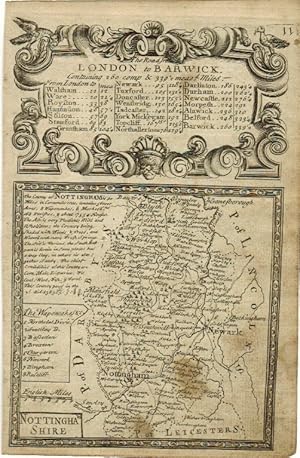
Nottinghamshire.
Verlag: London, c.1720. 185 x 115mm (7Ľ x 4˝ inches)., 1720
Anbieter: Tooley, Adams & Co., Wallingford, OXON, Vereinigtes Königreich
Verkäuferbewertung 5 von 5 Sternen
EUR 21,26
EUR 42,60 Versand
Versand von Vereinigtes Königreich nach USAAnzahl: 1 verfügbar
In den WarenkorbUncoloured; light age-toning and minor nicks to margins, otherwise very good condition. A miniature map of the county of Nottinghamshire, from the 'Britannia Depicta or Ogilby Improved' by John Owen and Emanuel Bowen. The verso has the road from London through Ware and on to Puckeridge.
-

Huntingdonshire.
Verlag: London, c.1720. 185 x 115mm (7Ľ x 4˝ inches)., 1720
Anbieter: Tooley, Adams & Co., Wallingford, OXON, Vereinigtes Königreich
Verkäuferbewertung 5 von 5 Sternen
EUR 21,26
EUR 42,60 Versand
Versand von Vereinigtes Königreich nach USAAnzahl: 1 verfügbar
In den WarenkorbUncoloured; very light age-toning to the edges, otherwise a fine example. A miniature map of the county from the 'Britannia Depicta or Ogilby Improved' by John Owen and Emanuel Bowen. The verso has the road from Huntingdon (town plan), through Erith, Ely and on to Soham.
-

Nottinghamshire.
Verlag: London, c.1720. 120 x 120mm (4ľ x 4ľ inches)., 1720
Anbieter: Tooley, Adams & Co., Wallingford, OXON, Vereinigtes Königreich
Verkäuferbewertung 5 von 5 Sternen
EUR 21,26
EUR 42,60 Versand
Versand von Vereinigtes Königreich nach USAAnzahl: 1 verfügbar
In den WarenkorbUncoloured; light age-toning and minor nicks to margins, otherwise fine condition. A miniature map of the county from the 'Britannia Depicta or Ogilby Improved' by John Owen and Emanuel Bowen. The verso has the road from London through Ware and on to Puckeridge.
-
1757 MAP of MIDDLESEX Divided into its Hundreds, containing the CITY of LONDON and WESMINSTER by Emanuel Bowen
Verlag: the General Magazine of Arts and Science, London, 1757
Anbieter: Andrew Cox PBFA, Shropshire, Vereinigtes Königreich
Verbandsmitglied: PBFA
Verkäuferbewertung 5 von 5 Sternen
Karte
EUR 41,34
EUR 22,36 Versand
Versand von Vereinigtes Königreich nach USAAnzahl: 1 verfügbar
In den WarenkorbNo Binding. Zustand: Very Good. Taken from the General Magazine of Arts and Science, published in 1757, this is a nice coloured example of this map of Middlesex by Emanuel Bowen, measuring 8 inches by 7 inches approx, some light foxing else in good general condition.
-

Northampton Shire Drawn from the best Authorities.
Verlag: London, 1754. 205 x 180mm (8 x 7 inches)., 1748
Anbieter: Tooley, Adams & Co., Wallingford, OXON, Vereinigtes Königreich
Verkäuferbewertung 5 von 5 Sternen
EUR 56,70
EUR 42,60 Versand
Versand von Vereinigtes Königreich nach USAAnzahl: 1 verfügbar
In den WarenkorbUncoloured; signs of old folds, light age-toning, trimmed to plate mark in bottom left corner, otherwise a good example. A decorative map of the county by Emanuel Bowen, printed for John Hinton for publication in 'The Universal Magazine'.
-

Bedford Shire.
Verlag: London, c.1720. 120 x 120mm (4ľ x 4ľ inches)., 1720
Anbieter: Tooley, Adams & Co., Wallingford, OXON, Vereinigtes Königreich
Verkäuferbewertung 5 von 5 Sternen
EUR 24,80
EUR 42,60 Versand
Versand von Vereinigtes Königreich nach USAAnzahl: 1 verfügbar
In den WarenkorbUncoloured; light age-toning and minor nicks to margins, otherwise fine condition. A miniature map of the county from the 'Britannia Depicta or Ogilby Improved' by John Owen and Emanuel Bowen. The verso has the road from Thetford to Norwich.
-
AN ACCURATE MAP OF THE COUNTY PALATINE OF CHESTER, Divided Into Its Hundreds, Drawn from the Best Authorities .
Sprache: Englisch
Verlag: Printed for John Bowles, Carrington Bowles & Robert Sayer, London, 1777
Anbieter: K Books Ltd ABA ILAB, York, YORKS, Vereinigtes Königreich
Verbandsmitglied: ABA ILAB PBFA
Verkäuferbewertung 5 von 5 Sternen
EUR 383,88
EUR 22,36 Versand
Versand von Vereinigtes Königreich nach USAAnzahl: 1 verfügbar
In den WarenkorbNo Binding. Zustand: Very Good. Bowen, Emanuel (illustrator). AN ACCURATE MAP OF THE COUNTY PALATINE OF CHESTER, Divided Into Its Hundreds, Drawn from the Best Authorities; assissted by the most approved modern maps & charts with historical extracts, relative to its trade, manufactures, natural produce and present state of te cit of Chester and the other principal towns. Published for John Bowles, Carrington Bowles & Robert Sayer in 1777 (later issue of 1750 map). No date shown, but date of 1777 deduced from the names of the printers. Plate size 30 x 23 ins, 78 x 60 cms - engraved portion 27 x 20 ins, 68 x 51 cms. Large folio showing central crease. A rare copy of a map of the county of Cheshire, colouring not contemporary but probably early last century. . A beautifully engraved map, showing towns, villages, hundreds, woods, rivers, with list of seats of nobility etc. There is quite a bit of text giving an account and history of Chester, Delamere Forest, Beeston Castle, Malpas, Altrincham, Thelwell, Northwich etc Very decorative with Arms of the Earl of Cholmondley with dedication, bottom right, and an ornamental cartouche with title and illustration showing salt industry - bottom left. Excellent condition. With fine wide margins - except for slight trimming at top left not affecting impressed portion. Attractive and scarce. Framed for collection only - if posted it will be rolled in a tube.
-

A Map of Westmorland.
Verlag: London, 1720. 120 x 115mm (4ľ x 4˝ inches)., 1720
Anbieter: Tooley, Adams & Co., Wallingford, OXON, Vereinigtes Königreich
Verkäuferbewertung 5 von 5 Sternen
EUR 28,35
EUR 42,60 Versand
Versand von Vereinigtes Königreich nach USAAnzahl: 1 verfügbar
In den WarenkorbFrom Britannia Depicta.
-
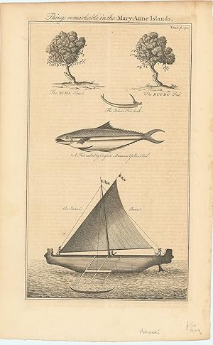
Things remarkable in the Mary-Anne Islands.
Verlag: London ., 1764
Anbieter: Robert Frew Ltd. ABA ILAB, London, Vereinigtes Königreich
Verbandsmitglied: ABA ILAB PBFA
Verkäuferbewertung 5 von 5 Sternen
Kunst / Grafik / Poster
EUR 59,06
EUR 11,47 Versand
Versand von Vereinigtes Königreich nach USAAnzahl: 1 verfügbar
In den WarenkorbOriginal uncoloured engraving. Plate dimensions 34 x 20 cm, overall sheet size 40 x 25 cm. Offsetting from text affecting image, generally very good. Engraving of fish, botany and boat of the Marianne Islands. From Harris's, Navigantium atque itinerantium bibliotheca or, a Complete Collection of Voyages and Travel.
-

A New & Correct Map of the Netherlands or Low Countries.
Verlag: London c., 1750
Anbieter: Robert Frew Ltd. ABA ILAB, London, Vereinigtes Königreich
Verbandsmitglied: ABA ILAB PBFA
Verkäuferbewertung 5 von 5 Sternen
Karte
EUR 59,06
EUR 11,47 Versand
Versand von Vereinigtes Königreich nach USAAnzahl: 1 verfügbar
In den Warenkorb34.6 x 42.6 cm. Uncoloured. Copper engraved general map of Belgium and the south of the Netherlands. Two vertical folds. Some light offsetting, otherwise in very good condition.
-

A Map of Rutland.
Verlag: London, c.1720. 120 x 120mm (4ľ x 4ľ inches)., 1720
Anbieter: Tooley, Adams & Co., Wallingford, OXON, Vereinigtes Königreich
Verkäuferbewertung 5 von 5 Sternen
EUR 29,53
EUR 42,60 Versand
Versand von Vereinigtes Königreich nach USAAnzahl: 1 verfügbar
In den WarenkorbUncoloured; light age-toning and minor nicks to margins, otherwise fine condition. A miniature map of the county from the 'Britannia Depicta or Ogilby Improved' by John Owen and Emanuel Bowen. The verso has the road from Puckeridge to Berton Mills.
-

Shropshire.
Verlag: London, c.1720. 120 x 120mm (4ľ x 4ľ inches)., 1720
Anbieter: Tooley, Adams & Co., Wallingford, OXON, Vereinigtes Königreich
Verkäuferbewertung 5 von 5 Sternen
EUR 29,53
EUR 42,60 Versand
Versand von Vereinigtes Königreich nach USAAnzahl: 1 verfügbar
In den WarenkorbUncoloured; light age-toning and minor nicks to margins, otherwise fine condition. A miniature map of the county from the 'Britannia Depicta or Ogilby Improved' by John Owen and Emanuel Bowen. The verso has the road from Meriden in Warwickshire to Wenlock in Shropshire.