
Gesamtpreis (1 Artikel Artikel):
Versandziel:

dutton capt clarence (20 Ergebnisse)
Direkt zu den wichtigsten Suchergebnissen
Suchfilter
Produktart
- Alle Product Types
- Bücher (2)
- Magazine & Zeitschriften (Keine weiteren Ergebnisse entsprechen dieser Verfeinerung)
- Comics (Keine weiteren Ergebnisse entsprechen dieser Verfeinerung)
- Noten (Keine weiteren Ergebnisse entsprechen dieser Verfeinerung)
- Kunst, Grafik & Poster (7)
- Fotografien (Keine weiteren Ergebnisse entsprechen dieser Verfeinerung)
- Karten (11)
- Manuskripte & Papierantiquitäten (Keine weiteren Ergebnisse entsprechen dieser Verfeinerung)
Zustand Mehr dazu
- Neu (Keine weiteren Ergebnisse entsprechen dieser Verfeinerung)
- Wie Neu, Sehr Gut oder Gut Bis Sehr Gut (Keine weiteren Ergebnisse entsprechen dieser Verfeinerung)
- Gut oder Befriedigend (2)
- Ausreichend oder Schlecht (Keine weiteren Ergebnisse entsprechen dieser Verfeinerung)
- Wie beschrieben (18)
Einband
- alle Einbände
- Hardcover (2)
- Softcover (Keine weiteren Ergebnisse entsprechen dieser Verfeinerung)
Weitere Eigenschaften
- Erstausgabe (1)
- Signiert (Keine weiteren Ergebnisse entsprechen dieser Verfeinerung)
- Schutzumschlag (Keine weiteren Ergebnisse entsprechen dieser Verfeinerung)
- Angebotsfoto (18)
Sprache (2)
Preis
- Beliebiger Preis
- Weniger als EUR 20 (Keine weiteren Ergebnisse entsprechen dieser Verfeinerung)
- EUR 20 bis EUR 45
- Mehr als EUR 45
Gratisversand
Land des Verkäufers
Verkäuferbewertung
-

Hawaiian Volcanoes
Sprache: Englisch
Verlag: Smithsonian, Washington, 1984
Anbieter: Alexander Books (ABAC/ILAB), Ancaster, ON, Kanada
Verkäuferbewertung 5 von 5 Sternen

Erstausgabe
Hardcover. Zustand: Good. 1st Edition. 144 Pages Illus. Maps, Fold Outs. Usual Ex-Lib Marks O/W Sound.
-
Atlas to Accompany the Monograph on the Tertiary History of the Grand Canyon District
Verlag: Department of the Interior, 1882
Anbieter: Arader Galleries - AraderNYC, New York, NY, USA
Verkäuferbewertung 5 von 5 Sternen
Hardcover. Zustand: Very Good. Washington: Department of the Interior, 1882. Folio (20 x 17 3/4 inches, 505mm x 450mm). Lithographed title page with 10 double-page colour tinted lithographed views of the Grand Canyon, including one after Thomas Moran, based on a sketch by Holmes, and 9 after William H.Holmes plates, 11 double-page colour printed lithographed maps, and 1 uncoloured map. Bound in original publisher's brown cloth with gilt stamped title to the front board. On the spine, library label 746 to foot. Head and foot of spine worn. Cover worn. Some shading to edges around maps. Rich tones and bright colors. Bookplate of James Strohm Copley, and label of Santa Cruz City Free Library. Library stamps throughout on back of prints.Moran's famous painting"The Grand Cańon of the Yellowstone" (1872) was the first landscape the government hung in the Capitol. It was purchased in June 1872, just three months after Congress voted to establish the Yellowstone area as the country's first national park. By 1873 Moran was in demand as an exploration artist. His work had been widely published, and The Grand Cańon of the Yellowstone had been favorably reviewed in newspapers and journals. Capt. Clarence Dutton (1841-1912 ) focused his early field work on the Colorado Plateau. Out of it came a trilogy of related studies: Report on the Geology of the High Plateaus of Utah (1880), the Tertiary History of the Grand Cańon District (1882), and Mount Taylor and the Zuńi Plateau (1886). His description of this erosion-sculpted terrain enshrined Dutton, along with Powell and G. K. Gilbert, into the founding pantheon of geomorphology and the "American school" of geology.
-
![Bild des Verkäufers für [The Grand Canyon]. Sketch Map of the Western Part of the Plateau Province showing the Faults of the Grand Cańon District and High Plateaus. zum Verkauf von Robert Frew Ltd. ABA ILAB](https://pictures.abebooks.com/inventory/md/md31029510190.jpg)
[The Grand Canyon]. Sketch Map of the Western Part of the Plateau Province showing the Faults of the Grand Cańon District and High Plateaus.
Verlag: WashingtonJulius Bien & Co. Lith. New York ., 1882
Anbieter: Robert Frew Ltd. ABA ILAB, London, Vereinigtes Königreich
Verbandsmitglied: ABA ILAB PBFA
Verkäuferbewertung 5 von 5 Sternen
Karte
EUR 118,67
EUR 11,52 Versand
Versand von Vereinigtes Königreich nach USAAnzahl: 1 verfügbar
In den WarenkorbOriginal double-page lithographed map of a section of the the Grand Canyon (overall dimensions 83.5 x 50.5 cm, map dimensions 73 x 45 cm) from Dutton's Atlas to Accompany the Monograph on the Tertiary History of the Grand Cańon District. Folding down the centre as issued. Ex libris Manchester Geological Society with their library stamp to upper portion. Generally very good. Clarence E. Dutton began working on his Tertiary History of the Grand Canon District while he was a member of the Powell survey. The Atlas beautifully illustrates the Grand Canyon with the use of color lithography by Julius Bien. Tertiary History was important both as a work of art and as the scientific foundation upon which subsequent mapping was based. It is one of the most important cartographic works devoted to the Grand Canyon.
-
![Bild des Verkäufers für [The Grand Canyon]. Geologic Map of the Southern Part of the Kaibab Plateau. Part II. North-Eastern Sheet. zum Verkauf von Robert Frew Ltd. ABA ILAB](https://pictures.abebooks.com/inventory/md/md31029516028.jpg)
[The Grand Canyon]. Geologic Map of the Southern Part of the Kaibab Plateau. Part II. North-Eastern Sheet.
Verlag: WashingtonJulius Bien & Co. Lith. New York ., 1882
Anbieter: Robert Frew Ltd. ABA ILAB, London, Vereinigtes Königreich
Verbandsmitglied: ABA ILAB PBFA
Verkäuferbewertung 5 von 5 Sternen
Karte
EUR 148,34
EUR 11,52 Versand
Versand von Vereinigtes Königreich nach USAAnzahl: 1 verfügbar
In den WarenkorbOriginal double-page chromolithographed map of a section of the the Grand Canyon (overall dimensions 83.5 x 50.5 cm, map dimensions 46.5 x 65 cm) from Dutton's Atlas to Accompany the Monograph on the Tertiary History of the Grand Cańon District. Folding down the centre as issued. Ex libris Manchester Geological Society with two of their library stamps to margins. Generally very good. Clarence E. Dutton began working on his Tertiary History of the Grand Canon District while he was a member of the Powell survey. The Atlas beautifully illustrates the Grand Canyon with the use of color lithography by Julius Bien. Tertiary History was important both as a work of art and as the scientific foundation upon which subsequent mapping was based. It is one of the most important cartographic works devoted to the Grand Canyon.
-
![Bild des Verkäufers für [The Grand Canyon]. Geological Map showing the South-Western Portion of the Mesozoic Terraces and the Vicinity of the Hurricane Fault. zum Verkauf von Robert Frew Ltd. ABA ILAB](https://pictures.abebooks.com/inventory/md/md31029516029.jpg)
[The Grand Canyon]. Geological Map showing the South-Western Portion of the Mesozoic Terraces and the Vicinity of the Hurricane Fault.
Verlag: WashingtonJulius Bien & Co. Lith. New York ., 1882
Anbieter: Robert Frew Ltd. ABA ILAB, London, Vereinigtes Königreich
Verbandsmitglied: ABA ILAB PBFA
Verkäuferbewertung 5 von 5 Sternen
Karte
EUR 148,34
EUR 11,52 Versand
Versand von Vereinigtes Königreich nach USAAnzahl: 1 verfügbar
In den WarenkorbOriginal double-page chromolithographed map of a section of the the Grand Canyon (overall dimensions 83.5 x 50.5 cm, map dimensions 46 x 71.5 cm) from Dutton's Atlas to Accompany the Monograph on the Tertiary History of the Grand Cańon District. Folding down the centre as issued. Ex libris Manchester Geological Society with two of their library stamps to margins. Generally very good. Clarence E. Dutton began working on his Tertiary History of the Grand Canon District while he was a member of the Powell survey. The Atlas beautifully illustrates the Grand Canyon with the use of color lithography by Julius Bien. Tertiary History was important both as a work of art and as the scientific foundation upon which subsequent mapping was based. It is one of the most important cartographic works devoted to the Grand Canyon.
-
![Bild des Verkäufers für [The Grand Canyon]. Geologic Map of the Grand Cańon in the Kaibab Plateau. Part III. South-Western Sheet. zum Verkauf von Robert Frew Ltd. ABA ILAB](https://pictures.abebooks.com/inventory/md/md31029516027.jpg)
[The Grand Canyon]. Geologic Map of the Grand Cańon in the Kaibab Plateau. Part III. South-Western Sheet.
Verlag: WashingtonJulius Bien & Co. Lith. New York ., 1882
Anbieter: Robert Frew Ltd. ABA ILAB, London, Vereinigtes Königreich
Verbandsmitglied: ABA ILAB PBFA
Verkäuferbewertung 5 von 5 Sternen
Karte
EUR 148,34
EUR 11,52 Versand
Versand von Vereinigtes Königreich nach USAAnzahl: 1 verfügbar
In den WarenkorbOriginal double-page chromolithographed map of a section of the the Grand Canyon (overall dimensions 83.5 x 50.5 cm, map dimensions 46.5 x 65 cm) from Dutton's Atlas to Accompany the Monograph on the Tertiary History of the Grand Cańon District. Folding down the centre as issued. Ex libris Manchester Geological Society with two of their library stamps to margins. Generally very good. Clarence E. Dutton began working on his Tertiary History of the Grand Canon District while he was a member of the Powell survey. The Atlas beautifully illustrates the Grand Canyon with the use of color lithography by Julius Bien. Tertiary History was important both as a work of art and as the scientific foundation upon which subsequent mapping was based. It is one of the most important cartographic works devoted to the Grand Canyon.
-
![Bild des Verkäufers für [The Grand Canyon]. Geologic Map of the Southern Part of the Kaibab Plateau. Part I. North-Western Sheet. zum Verkauf von Robert Frew Ltd. ABA ILAB](https://pictures.abebooks.com/inventory/md/md31029514054.jpg)
[The Grand Canyon]. Geologic Map of the Southern Part of the Kaibab Plateau. Part I. North-Western Sheet.
Verlag: WashingtonJulius Bien & Co. Lith. New York ., 1882
Anbieter: Robert Frew Ltd. ABA ILAB, London, Vereinigtes Königreich
Verbandsmitglied: ABA ILAB PBFA
Verkäuferbewertung 5 von 5 Sternen
Karte
EUR 178,01
EUR 11,52 Versand
Versand von Vereinigtes Königreich nach USAAnzahl: 1 verfügbar
In den WarenkorbOriginal double-page chromolithographed map of a section of the the Grand Canyon (overall dimensions 83.5 x 50.5 cm, map dimensions 46.5 x 65 cm) from Dutton's Atlas to Accompany the Monograph on the Tertiary History of the Grand Cańon District. Folding down the centre as issued. Ex libris Manchester Geological Society with two of their library stamps to margins. A few marginal nicks, generally very good. Clarence E. Dutton began working on his Tertiary History of the Grand Canon District while he was a member of the Powell survey. The Atlas beautifully illustrates the Grand Canyon with the use of color lithography by Julius Bien. Tertiary History was important both as a work of art and as the scientific foundation upon which subsequent mapping was based. It is one of the most important cartographic works devoted to the Grand Canyon.
-
![Bild des Verkäufers für [The Grand Canyon]. Map of the Uinkaret Plateau. North Half. zum Verkauf von Robert Frew Ltd. ABA ILAB](https://pictures.abebooks.com/inventory/md/md31029514056.jpg)
[The Grand Canyon]. Map of the Uinkaret Plateau. North Half.
Verlag: WashingtonJulius Bien & Co. Lith. New York ., 1882
Anbieter: Robert Frew Ltd. ABA ILAB, London, Vereinigtes Königreich
Verbandsmitglied: ABA ILAB PBFA
Verkäuferbewertung 5 von 5 Sternen
Karte
EUR 237,34
EUR 11,52 Versand
Versand von Vereinigtes Königreich nach USAAnzahl: 1 verfügbar
In den WarenkorbOriginal double-page chromolithographed map of a section of the the Grand Canyon (overall dimensions 83.5 x 50.5 cm, map dimensions 46.5 x 77.5 cm) from Dutton's Atlas to Accompany the Monograph on the Tertiary History of the Grand Cańon District. Folding down the centre as issued. Ex libris Manchester Geological Society with their library stamp to upper margin. Small marginal nick along bottom of centre-fold, minor smudging, generally very good. Clarence E. Dutton began working on his Tertiary History of the Grand Canon District while he was a member of the Powell survey. The Atlas beautifully illustrates the Grand Canyon with the use of color lithography by Julius Bien. Tertiary History was important both as a work of art and as the scientific foundation upon which subsequent mapping was based. It is one of the most important cartographic works devoted to the Grand Canyon.
-
![Bild des Verkäufers für [The Grand Canyon]. Geological Map showing the Kanab, Kaibab, Paria and Marble Cańon Platforms. zum Verkauf von Robert Frew Ltd. ABA ILAB](https://pictures.abebooks.com/inventory/md/md31029515058.jpg)
[The Grand Canyon]. Geological Map showing the Kanab, Kaibab, Paria and Marble Cańon Platforms.
Verlag: WashingtonJulius Bien & Co. Lith. New York ., 1882
Anbieter: Robert Frew Ltd. ABA ILAB, London, Vereinigtes Königreich
Verbandsmitglied: ABA ILAB PBFA
Verkäuferbewertung 5 von 5 Sternen
Karte
EUR 237,34
EUR 11,52 Versand
Versand von Vereinigtes Königreich nach USAAnzahl: 1 verfügbar
In den WarenkorbOriginal double-page chromolithographed map of a section of the the Grand Canyon (overall dimensions 83.5 x 50.5 cm, map dimensions 71.5 x 46 cm) from Dutton's Atlas to Accompany the Monograph on the Tertiary History of the Grand Cańon District. Folding down the centre as issued. Ex libris Manchester Geological Society with two of their library stamps to margins. Generally very good. Clarence E. Dutton began working on his Tertiary History of the Grand Canon District while he was a member of the Powell survey. The Atlas beautifully illustrates the Grand Canyon with the use of color lithography by Julius Bien. Tertiary History was important both as a work of art and as the scientific foundation upon which subsequent mapping was based. It is one of the most important cartographic works devoted to the Grand Canyon.
-
![Bild des Verkäufers für [The Grand Canyon]. Map of the Uinkaret Plateau. South Half. zum Verkauf von Robert Frew Ltd. ABA ILAB](https://pictures.abebooks.com/inventory/md/md31029514055.jpg)
[The Grand Canyon]. Map of the Uinkaret Plateau. South Half.
Verlag: WashingtonJulius Bien & Co. Lith. New York ., 1882
Anbieter: Robert Frew Ltd. ABA ILAB, London, Vereinigtes Königreich
Verbandsmitglied: ABA ILAB PBFA
Verkäuferbewertung 5 von 5 Sternen
Karte
EUR 237,34
EUR 11,52 Versand
Versand von Vereinigtes Königreich nach USAAnzahl: 1 verfügbar
In den WarenkorbOriginal double-page chromolithographed map of a section of the the Grand Canyon (overall dimensions 83.5 x 50.5 cm, map dimensions 46.5 x 77.5 cm) from Dutton's Atlas to Accompany the Monograph on the Tertiary History of the Grand Cańon District. Folding down the centre as issued. Ex libris Manchester Geological Society with their library stamp to upper margin. A few marginal nicks, generally very good. Clarence E. Dutton began working on his Tertiary History of the Grand Canon District while he was a member of the Powell survey. The Atlas beautifully illustrates the Grand Canyon with the use of color lithography by Julius Bien. Tertiary History was important both as a work of art and as the scientific foundation upon which subsequent mapping was based. It is one of the most important cartographic works devoted to the Grand Canyon.
-
![Bild des Verkäufers für [The Grand Canyon]. Geological Map of the Mesozoic Terraces of the Grand Cańon District. zum Verkauf von Robert Frew Ltd. ABA ILAB](https://pictures.abebooks.com/inventory/md/md31029506479.jpg)
[The Grand Canyon]. Geological Map of the Mesozoic Terraces of the Grand Cańon District.
Verlag: WashingtonJulius Bien & Co. Lith. New York ., 1882
Anbieter: Robert Frew Ltd. ABA ILAB, London, Vereinigtes Königreich
Verbandsmitglied: ABA ILAB PBFA
Verkäuferbewertung 5 von 5 Sternen
Karte
EUR 237,34
EUR 11,52 Versand
Versand von Vereinigtes Königreich nach USAAnzahl: 1 verfügbar
In den WarenkorbOriginal double-page chromolithographed map of a section of the the Grand Canyon (overall dimensions 83.5 x 50.5 cm, map dimensions 71.5 x 46 cm) from Dutton's Atlas to Accompany the Monograph on the Tertiary History of the Grand Cańon District. Folding down the centre as issued. Ex libris Manchester Geological Society with two of their library stamps to margins. Minor marginal nicks and toning, generally very good. Clarence E. Dutton began working on his Tertiary History of the Grand Canon District while he was a member of the Powell survey. The Atlas beautifully illustrates the Grand Canyon with the use of color lithography by Julius Bien. Tertiary History was important both as a work of art and as the scientific foundation upon which subsequent mapping was based. It is one of the most important cartographic works devoted to the Grand Canyon.
-
![Bild des Verkäufers für [The Grand Canyon]. Geological Map of the Colorado Plateau and San Francisco Mountains. zum Verkauf von Robert Frew Ltd. ABA ILAB](https://pictures.abebooks.com/inventory/md/md31029515052.jpg)
[The Grand Canyon]. Geological Map of the Colorado Plateau and San Francisco Mountains.
Verlag: WashingtonJulius Bien & Co. Lith. New York ., 1882
Anbieter: Robert Frew Ltd. ABA ILAB, London, Vereinigtes Königreich
Verbandsmitglied: ABA ILAB PBFA
Verkäuferbewertung 5 von 5 Sternen
Karte
EUR 237,34
EUR 11,52 Versand
Versand von Vereinigtes Königreich nach USAAnzahl: 1 verfügbar
In den WarenkorbOriginal double-page chromolithographed map of a section of the the Grand Canyon (overall dimensions 83.5 x 50.5 cm, map dimensions 71.5 x 46 cm) from Dutton's Atlas to Accompany the Monograph on the Tertiary History of the Grand Cańon District. Folding down the centre as issued. Ex libris Manchester Geological Society with two of their library stamps to margins. Generally very good. Clarence E. Dutton began working on his Tertiary History of the Grand Canon District while he was a member of the Powell survey. The Atlas beautifully illustrates the Grand Canyon with the use of color lithography by Julius Bien. Tertiary History was important both as a work of art and as the scientific foundation upon which subsequent mapping was based. It is one of the most important cartographic works devoted to the Grand Canyon.
-
![Bild des Verkäufers für [The Grand Canyon]. Looking up the Toroweap from Vulcan's Throne. zum Verkauf von Robert Frew Ltd. ABA ILAB](https://pictures.abebooks.com/inventory/md/md31029510191.jpg)
[The Grand Canyon]. Looking up the Toroweap from Vulcan's Throne.
Verlag: WashingtonJulius Bien & Co. Lith. New York ., 1882
Anbieter: Robert Frew Ltd. ABA ILAB, London, Vereinigtes Königreich
Verbandsmitglied: ABA ILAB PBFA
Verkäuferbewertung 5 von 5 Sternen
Kunst / Grafik / Poster
EUR 296,68
EUR 11,52 Versand
Versand von Vereinigtes Königreich nach USAAnzahl: 1 verfügbar
In den WarenkorbTwo panoramic tinted lithograph views of Grand Canyon on one sheet (overall dimensions 83.5 x 50.5 cm, print dimensions 19.5 x 74.5 cm each) from Dutton's Atlas to Accompany the Monograph on the Tertiary History of the Grand Cańon District. Folding down the centre as issued. Ex libris Manchester Geological Society with two of their library stamps to upper margin. A few small marginal nicks and tears, generally very good. Clarence E. Dutton began working on his Tertiary History of the Grand Canon District while he was a member of the Powell survey. The Atlas beautifully illustrates the Grand Canyon with the use of color lithography by Julius Bien. The panoramas of the spectacular river gorge are after the paintings of two brilliant topographical artists, W. H. Holmes and Thomas Moran. Tertiary History was important both as a work of art and as the scientific foundation upon which subsequent mapping was based. It is one of the most important cartographic works devoted to the Grand Canyon.
-
![Bild des Verkäufers für [The Grand Canyon]. Views from Mt. Trumbull and Mt. Emma. zum Verkauf von Robert Frew Ltd. ABA ILAB](https://pictures.abebooks.com/inventory/md/md31029514057.jpg)
[The Grand Canyon]. Views from Mt. Trumbull and Mt. Emma.
Verlag: WashingtonJulius Bien & Co. Lith. New York ., 1882
Anbieter: Robert Frew Ltd. ABA ILAB, London, Vereinigtes Königreich
Verbandsmitglied: ABA ILAB PBFA
Verkäuferbewertung 5 von 5 Sternen
Kunst / Grafik / Poster
EUR 296,68
EUR 11,52 Versand
Versand von Vereinigtes Königreich nach USAAnzahl: 1 verfügbar
In den WarenkorbTwo panoramic tinted lithograph views of Grand Canyon on one sheet (overall dimensions 83.5 x 50.5 cm, print dimensions 19.5 x 74.5 cm each) from Dutton's Atlas to Accompany the Monograph on the Tertiary History of the Grand Cańon District. Mounted onto pasteboard. Ex libris Manchester Geological Society with two of their library stamps to upper margin. Generally very good. Clarence E. Dutton began working on his Tertiary History of the Grand Canon District while he was a member of the Powell survey. The Atlas beautifully illustrates the Grand Canyon with the use of color lithography by Julius Bien. The panoramas of the spectacular river gorge are after the paintings of two brilliant topographical artists, W. H. Holmes and Thomas Moran. Tertiary History was important both as a work of art and as the scientific foundation upon which subsequent mapping was based. It is one of the most important cartographic works devoted to the Grand Canyon.
-
![Bild des Verkäufers für [The Grand Canyon]. Views of the Marble Cańon Platform from the Eastern Brink of the Kaibab. zum Verkauf von Robert Frew Ltd. ABA ILAB](https://pictures.abebooks.com/inventory/md/md31029515060.jpg)
[The Grand Canyon]. Views of the Marble Cańon Platform from the Eastern Brink of the Kaibab.
Verlag: WashingtonJulius Bien & Co. Lith. New York ., 1882
Anbieter: Robert Frew Ltd. ABA ILAB, London, Vereinigtes Königreich
Verbandsmitglied: ABA ILAB PBFA
Verkäuferbewertung 5 von 5 Sternen
Kunst / Grafik / Poster
EUR 296,68
EUR 11,52 Versand
Versand von Vereinigtes Königreich nach USAAnzahl: 1 verfügbar
In den WarenkorbTwo panoramic tinted lithograph views of Grand Canyon on one sheet (overall dimensions 83.5 x 50.5 cm, print dimensions 19.5 x 74.5 cm each) from Dutton's Atlas to Accompany the Monograph on the Tertiary History of the Grand Cańon District. Folding down the centre as issued. Ex libris Manchester Geological Society with two of their library stamps to upper margin. One small marginal nick, generally very good. Clarence E. Dutton began working on his Tertiary History of the Grand Canon District while he was a member of the Powell survey. The Atlas beautifully illustrates the Grand Canyon with the use of color lithography by Julius Bien. The panoramas of the spectacular river gorge are after the paintings of two brilliant topographical artists, W. H. Holmes and Thomas Moran. Tertiary History was important both as a work of art and as the scientific foundation upon which subsequent mapping was based. It is one of the most important cartographic works devoted to the Grand Canyon.
-
![Bild des Verkäufers für [The Grand Canyon]. The Temples and Towers of the Virgen. zum Verkauf von Robert Frew Ltd. ABA ILAB](https://pictures.abebooks.com/inventory/md/md31029515053.jpg)
[The Grand Canyon]. The Temples and Towers of the Virgen.
Verlag: WashingtonJulius Bien & Co. Lith. New York ., 1882
Anbieter: Robert Frew Ltd. ABA ILAB, London, Vereinigtes Königreich
Verbandsmitglied: ABA ILAB PBFA
Verkäuferbewertung 5 von 5 Sternen
Kunst / Grafik / Poster
EUR 296,68
EUR 11,52 Versand
Versand von Vereinigtes Königreich nach USAAnzahl: 1 verfügbar
In den WarenkorbOriginal tinted lithograph view of Grand Canyon (overall dimensions 83.5 x 50.5 cm, print dimensions 44.5 x 77 cm) from Dutton's Atlas to Accompany the Monograph on the Tertiary History of the Grand Cańon District. Folding down the centre as issued. Ex libris Manchester Geological Society with their library stamp to upper margin. Small nicks to bottom margin, small tear without loss to bottom central portion of print, generally very good. Clarence E. Dutton began working on his Tertiary History of the Grand Canon District while he was a member of the Powell survey. The Atlas beautifully illustrates the Grand Canyon with the use of color lithography by Julius Bien. The panoramas of the spectacular river gorge are after the paintings of two brilliant topographical artists, W. H. Holmes and Thomas Moran. Tertiary History was important both as a work of art and as the scientific foundation upon which subsequent mapping was based. It is one of the most important cartographic works devoted to the Grand Canyon.
-
![Bild des Verkäufers für [The Grand Canyon]. Views Looking East and South from Mt. Trumbull. zum Verkauf von Robert Frew Ltd. ABA ILAB](https://pictures.abebooks.com/inventory/md/md31029515059.jpg)
[The Grand Canyon]. Views Looking East and South from Mt. Trumbull.
Verlag: WashingtonJulius Bien & Co. Lith. New York ., 1882
Anbieter: Robert Frew Ltd. ABA ILAB, London, Vereinigtes Königreich
Verbandsmitglied: ABA ILAB PBFA
Verkäuferbewertung 5 von 5 Sternen
Kunst / Grafik / Poster
EUR 296,68
EUR 11,52 Versand
Versand von Vereinigtes Königreich nach USAAnzahl: 1 verfügbar
In den WarenkorbTwo panoramic tinted lithograph views of Grand Canyon on one sheet (overall dimensions 83.5 x 50.5 cm, print dimensions 19.5 x 74.5 cm each) from Dutton's Atlas to Accompany the Monograph on the Tertiary History of the Grand Cańon District. Folding down the centre as issued. Ex libris Manchester Geological Society with two of their library stamps to upper margin. Small tear to bottom left margin just encroaching on print, a few small marginal nicks, generally very good. Clarence E. Dutton began working on his Tertiary History of the Grand Canon District while he was a member of the Powell survey. The Atlas beautifully illustrates the Grand Canyon with the use of color lithography by Julius Bien. The panoramas of the spectacular river gorge are after the paintings of two brilliant topographical artists, W. H. Holmes and Thomas Moran. Tertiary History was important both as a work of art and as the scientific foundation upon which subsequent mapping was based. It is one of the most important cartographic works devoted to the Grand Canyon.
-
![Bild des Verkäufers für [The Grand Canyon]. Geologic Map of the Southern Part of the Kaibab Plateau-Head of the Grand Cańon. Part IV. South-Eastern Sheet. zum Verkauf von Robert Frew Ltd. ABA ILAB](https://pictures.abebooks.com/inventory/md/md31029514053.jpg)
[The Grand Canyon]. Geologic Map of the Southern Part of the Kaibab Plateau-Head of the Grand Cańon. Part IV. South-Eastern Sheet.
Verlag: WashingtonJulius Bien & Co. Lith. New York ., 1882
Anbieter: Robert Frew Ltd. ABA ILAB, London, Vereinigtes Königreich
Verbandsmitglied: ABA ILAB PBFA
Verkäuferbewertung 5 von 5 Sternen
Karte
EUR 296,68
EUR 11,52 Versand
Versand von Vereinigtes Königreich nach USAAnzahl: 1 verfügbar
In den WarenkorbOriginal double-page chromolithographed map of a section of the the Grand Canyon (overall dimensions 83.5 x 50.5 cm, map dimensions 46.5 x 65 cm) from Dutton's Atlas to Accompany the Monograph on the Tertiary History of the Grand Cańon District. Folding down the centre as issued. Ex libris Manchester Geological Society with two of their library stamps to margins. A few marginal nicks, generally very good. Clarence E. Dutton began working on his Tertiary History of the Grand Canon District while he was a member of the Powell survey. The Atlas beautifully illustrates the Grand Canyon with the use of color lithography by Julius Bien. Tertiary History was important both as a work of art and as the scientific foundation upon which subsequent mapping was based. It is one of the most important cartographic works devoted to the Grand Canyon.
-
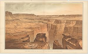
The Grand Cańon at the Foot of the Toroweap-Looking East.
Verlag: WashingtonJulius Bien & Co. Lith. New York ., 1882
Anbieter: Robert Frew Ltd. ABA ILAB, London, Vereinigtes Königreich
Verbandsmitglied: ABA ILAB PBFA
Verkäuferbewertung 5 von 5 Sternen
Kunst / Grafik / Poster
EUR 890,03
EUR 11,52 Versand
Versand von Vereinigtes Königreich nach USAAnzahl: 1 verfügbar
In den WarenkorbOriginal double-page chromolithographed panoramic view of the Grand Canyon (overall dimensions 83.5 x 50.5 cm, print dimensions 45 x 75 cm) from Dutton's Atlas to Accompany the Monograph on the Tertiary History of the Grand Cańon District. Folding down the centre as issued. Ex libris Manchester Geological Society with their library stamp to upper margin. Small loss to upper margin not affecting print, discreet 10 cm tear to left portion stabilised by archival tape, generally very good condition. Clarence E. Dutton began working on his Tertiary History of the Grand Canon District while he was a member of the Powell survey. The Atlas beautifully illustrates the Grand Canyon with the use of color lithography by Julius Bien. The panoramas of the spectacular river gorge are after the paintings of two brilliant topographical artists, W. H. Holmes and Thomas Moran. Tertiary History was important both as a work of art and as the scientific foundation upon which subsequent mapping was based. It is one of the most important cartographic works devoted to the Grand Canyon.
-
[The Grand Canyon]. Panorama from Point Sublime (on three sheets).
Verlag: WashingtonJulius Bien & Co. Lith. New York ., 1882
Anbieter: Robert Frew Ltd. ABA ILAB, London, Vereinigtes Königreich
Verbandsmitglied: ABA ILAB PBFA
Verkäuferbewertung 5 von 5 Sternen
Kunst / Grafik / Poster
EUR 2.966,78
EUR 11,52 Versand
Versand von Vereinigtes Königreich nach USAAnzahl: 1 verfügbar
In den WarenkorbOriginal double-page chromolithographed panoramic view of the Grand Canyon comprising three sheets (overall dimensions 83.5 x 50.5 cm, print dimensions 45 x 75 cm) from Dutton's Atlas to Accompany the Monograph on the Tertiary History of the Grand Cańon District. Each sheet folds down the centre as issued. Part 1 entitled "Looking East", Part 2 "Looking South" and Part 3 "Looking West". Ex libris Manchester Geological Society with two of their library stamps to upper margins of each print. Small marginal nicks and tears not affecting images, generally very good condition. Clarence E. Dutton began working on his Tertiary History of the Grand Canon District while he was a member of the Powell survey. The Atlas beautifully illustrates the Grand Canyon with the use of color lithography by Julius Bien. The panoramas of the spectacular river gorge are after the paintings of two brilliant topographical artists, W. H. Holmes and Thomas Moran. Tertiary History was important both as a work of art and as the scientific foundation upon which subsequent mapping was based. It is one of the most important cartographic works devoted to the Grand Canyon.

![Bild des Verkäufers für [The Grand Canyon]. Panorama from Point Sublime (on three sheets). zum Verkauf von Robert Frew Ltd. ABA ILAB](https://pictures.abebooks.com/inventory/md/md31029513133.jpg)