
Gesamtpreis (1 Artikel Artikel):
Versandziel:

den helder (10 Ergebnisse)
Direkt zu den wichtigsten Suchergebnissen
Suchfilter
Produktart
- Alle Product Types
- Bücher (10)
- Magazine & Zeitschriften (Keine weiteren Ergebnisse entsprechen dieser Verfeinerung)
- Comics (Keine weiteren Ergebnisse entsprechen dieser Verfeinerung)
- Noten (Keine weiteren Ergebnisse entsprechen dieser Verfeinerung)
- Kunst, Grafik & Poster (Keine weiteren Ergebnisse entsprechen dieser Verfeinerung)
- Fotografien (Keine weiteren Ergebnisse entsprechen dieser Verfeinerung)
- Karten (Keine weiteren Ergebnisse entsprechen dieser Verfeinerung)
- Manuskripte & Papierantiquitäten (Keine weiteren Ergebnisse entsprechen dieser Verfeinerung)
Zustand Mehr dazu
- Neu (Keine weiteren Ergebnisse entsprechen dieser Verfeinerung)
- Wie Neu, Sehr Gut oder Gut Bis Sehr Gut (1)
- Gut oder Befriedigend (3)
- Ausreichend oder Schlecht (Keine weiteren Ergebnisse entsprechen dieser Verfeinerung)
- Wie beschrieben (6)
Einband
- alle Einbände
- Hardcover (Keine weiteren Ergebnisse entsprechen dieser Verfeinerung)
- Softcover (3)
Weitere Eigenschaften
- Erstausgabe (Keine weiteren Ergebnisse entsprechen dieser Verfeinerung)
- Signiert (Keine weiteren Ergebnisse entsprechen dieser Verfeinerung)
- Schutzumschlag (Keine weiteren Ergebnisse entsprechen dieser Verfeinerung)
- Angebotsfoto (6)
Sprache (4)
Gratisversand
- Kostenloser Versand nach USA (Keine weiteren Ergebnisse entsprechen dieser Verfeinerung)
Land des Verkäufers
Verkäuferbewertung
-
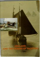
Holland, and the Origins of Yachting
Anbieter: RIVERLEE BOOKS, Waltham Cross, HERTS, Vereinigtes Königreich
Verkäuferbewertung 5 von 5 Sternen

EUR 11,28
EUR 13,88 Versand
Versand von Vereinigtes Königreich nach USAAnzahl: 1 verfügbar
In den WarenkorbSoft cover. Zustand: Good. Good condition soft cover, some wear to cover and spine, crease to front cover, internally clean and tidy with unmarked pages, in a very good readable condition.
-

Zustand: Good. Losbladig in metalen snelhechtertabellen, 4to.
-

Paperback. Zustand: Good. 96 p. : ill. ; 28 cm. Dutch 2e dr. Met reg. Subject: Recepten voor allerlei gerechten, voorzien van veel kleurenfoto's. Vanaf ca. 9 jaar. Jullie vinden in dit boekje makkelijke, snelle en natuurlijk ontzettend lekkere recepten waarmee koken een groot feest wordt en bijna geen moeite kost. Weten jullie wat ook ontzettend leuk is om te doen? ZELF BAKKEN! Jawel - niet alleen maar de deegrestjes uit de kom snoepen, maar zelf een houten lepel pakken en de meest verrukkelijke dingetjes uit de oven toveren. Ok dan, op de plaatsen . klaar, af! Laten we aan de slag(room) gaan.
-
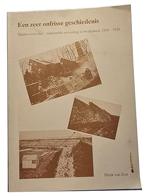
Een zeer onfrisse geschiedenis. Studies over de niet-industriele vervuiling in Nederland 1850-1920 Groningen 1986
Anbieter: Antiquariaat Arine van der Steur / ILAB, Den Haag, Niederlande
Verkäuferbewertung 4 von 5 Sternen

Diss. Groningen letteren 18-12-1986 ; 344 p. met los blad stellingen.D5381.
-

Postkarte: Den Helder - Waddenzeestraat.
Sprache: Deutsch
Verlag: Nr. 6395., Ohne Jahr (um 1960)., 1960
Anbieter: Antiquariat Ralf Rindle, Cuxhaven, Deutschland
Verkäuferbewertung 5 von 5 Sternen
13,7 x 8,8 cm. Zustand: Wie neu. Ungelaufene Ansichtskarte. Guter Zustand. Mit offener Rechnung versenden wir gerne an Bibliotheken und Institutionen, Schulen, Universitäten etc. Sprache: Deutsch Gewicht in Gramm: 100.
-

XIX . theses juridicae. 1793
Anbieter: Antiquariaat Arine van der Steur / ILAB, Den Haag, Niederlande
Verkäuferbewertung 4 von 5 Sternen
Diss. Leiden rechtsgeleerdheid 13-3-1793 ; 1 blad plano.
-
Diss. Leiden rechtsgeleerdheid 24-10-l792 ; 1 blad plano.
-

MARINE KIM 1929 | Toespraak van de reunist J.A. van der Star op het reunistendiner 1854-1929 op het K.I.M. Den Helder 1929, 4°, 3 pag., gedrukt.
Anbieter: Antiquariaat Arine van der Steur / ILAB, Den Haag, Niederlande
Verkäuferbewertung 4 von 5 Sternen
Met: toegangsbewijs muziekuitvoering; gedrukt briefje van Van der Star ter begeleiding van de Toespraak; legitimatiebewijs voor J.W.K. Tijl als deelnemer aan de reunie. M13223.
-
Helder in diamanten prentbriefkaarten.
Anbieter: Frans Melk Antiquariaat, HILVERSUM, Niederlande
Verkäuferbewertung 5 von 5 Sternen
Mapje met 8 kaarten. Herdruk van kaarten uit 1895 - 1923. Uitgaaf Boek Handel P. Spruit jr. [Topography / Dutch [Nederlandse Topografie] ].
-
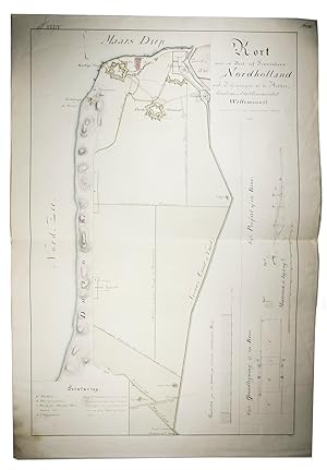
Kort over en deel af provindsen Nordholland med befestningen af de Helder, maritime & etablissementet Willemsoort samt en deel af den nye Nordhollandske Canal.
Verlag: [The Netherlands?],, 1825
Anbieter: ASHER Rare Books, T Goy Houten, Niederlande
Verkäuferbewertung 5 von 5 Sternen
EUR 1.800,00
EUR 25,00 Versand
Versand von Niederlande nach USAAnzahl: 1 verfügbar
In den WarenkorbManuscript fortification plan, showing the Den Helder fortifications and the Willemsoord shipyard, built in the 19th century as commissioned by Napoleon Bonaparte, drawn by the Danish-Norwegian military engineer and quartermaster Rasmus Krag (1763-1838). The map shows the so-called Den Helder fortifications, also known as the "Stelling Den Helder", an impressive line of forts, defensive works and connecting dikes. This line had already been used during the Eighty Years' War against sea attacks. In 1811 Napoleon gave the order to expand it, wanting to make Den Helder the war harbour of The Netherlands because of its strategic location.The plan is numbered in the upper left corner "Pl. XXXIV" in red ink and "Nr. 16" in the right upper corner in black ink, the latter struck through, and signed by "Krag" in the lower right corner below the plan. Some marginal soiling, stain in the lower left corner and some small spots on the plan, small tear in the upper left corner, but overall in good condition. A highly interesting and finely executed manuscript plan, important for Dutch maritime and military history. Folded. With a pen and ink-drawn fortification plan (ca. 85 x 55 cm) of the Den Helder fortifications and the marine shipyard Willemsoord, coloured by a contemporary hand, with a manuscript title, scales and a key in Danish, written in a fine and legible 19th-century hand surrounding the plan. On Whatman wove paper. Pages: [1] sheet.
