Gesamtpreis (1 Artikel Artikel):
Versandziel:

davies benjamin rees (29 Ergebnisse)
Direkt zu den wichtigsten Suchergebnissen
Suchfilter
Produktart
- Alle Product Types
- Bücher (2)
- Magazine & Zeitschriften (Keine weiteren Ergebnisse entsprechen dieser Verfeinerung)
- Comics (Keine weiteren Ergebnisse entsprechen dieser Verfeinerung)
- Noten (Keine weiteren Ergebnisse entsprechen dieser Verfeinerung)
- Kunst, Grafik & Poster (Keine weiteren Ergebnisse entsprechen dieser Verfeinerung)
- Fotografien (Keine weiteren Ergebnisse entsprechen dieser Verfeinerung)
- Karten (27)
- Manuskripte & Papierantiquitäten (Keine weiteren Ergebnisse entsprechen dieser Verfeinerung)
Zustand Mehr dazu
- Neu (Keine weiteren Ergebnisse entsprechen dieser Verfeinerung)
- Wie Neu, Sehr Gut oder Gut Bis Sehr Gut (Keine weiteren Ergebnisse entsprechen dieser Verfeinerung)
- Gut oder Befriedigend (19)
- Ausreichend oder Schlecht (5)
- Wie beschrieben (5)
Einband
- alle Einbände
- Hardcover (2)
- Softcover (Keine weiteren Ergebnisse entsprechen dieser Verfeinerung)
Weitere Eigenschaften
- Erstausgabe (Keine weiteren Ergebnisse entsprechen dieser Verfeinerung)
- Signiert (Keine weiteren Ergebnisse entsprechen dieser Verfeinerung)
- Schutzumschlag (Keine weiteren Ergebnisse entsprechen dieser Verfeinerung)
- Angebotsfoto (28)
Sprache (2)
Gratisversand
- Kostenloser Versand nach USA (Keine weiteren Ergebnisse entsprechen dieser Verfeinerung)
Land des Verkäufers
Verkäuferbewertung
-
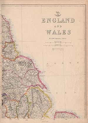
England and Wales
Erscheinungsdatum: 1863
Anbieter: Antiqua Print Gallery, London, Vereinigtes Königreich
Verkäuferbewertung 5 von 5 Sternen

Karte
EUR 8,27
EUR 11,47 Versand
Versand von Vereinigtes Königreich nach USAAnzahl: 2 verfügbar
In den WarenkorbZustand: Good. ENGLAND NORTH EAST COAST Lincs Yorks Durham Northumbs. >Berwick WELLER 1863 map. Antique map with original outline colour; Engraved by B.R. Davies (1863). 45.5 x 32.5cm, 18 x 12.75 inches. Condition: Good. The image shown may have been taken from a different example of this map than that which is offered for sale. The map you will receive is in good condition but there may be minor variations in the condition from that shown in the image. This map was coloured by hand at the time of publication, thus the colouration may vary slightly between different examples of the map; the colouring applied to the map you receive may differ slightly from that shown in the image. There is nothing printed on the reverse side, which is plain.
-
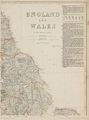
England and Wales
Erscheinungsdatum: 1862
Anbieter: Antiqua Print Gallery, London, Vereinigtes Königreich
Verkäuferbewertung 5 von 5 Sternen
Karte
EUR 8,27
EUR 11,47 Versand
Versand von Vereinigtes Königreich nach USAAnzahl: 2 verfügbar
In den WarenkorbZustand: Fair. ENGLAND NORTH EAST COAST Yorks Lincs Durham Northumbs. >Berwick. WELLER 1862 map. Antique map with original outline colour; Engraved by B.R. Davies (1862). 45.5 x 32.5cm, 18 x 12.75 inches. Condition: Fair: Blemishes. Tight left margin; Blemish in margin; Light spotting. There is nothing printed on the reverse side, which is plain.
-
England and Wales
Erscheinungsdatum: 1863
Anbieter: Antiqua Print Gallery, London, Vereinigtes Königreich
Verkäuferbewertung 5 von 5 Sternen
Karte
EUR 8,27
EUR 11,47 Versand
Versand von Vereinigtes Königreich nach USAAnzahl: 1 verfügbar
In den WarenkorbZustand: Good. ENGLAND NORTH EAST COAST Yorks Lincs Durham Northumbs. >Berwick. WELLER 1863 map. Antique map with original outline colour; Engraved by B.R. Davies (1863). 45.5 x 32.5cm, 18 x 12.75 inches. Condition: Good. The image shown may have been taken from a different example of this map than that which is offered for sale. The map you will receive is in good condition but there may be minor variations in the condition from that shown in the image. This map was coloured by hand at the time of publication, thus the colouration may vary slightly between different examples of the map; the colouring applied to the map you receive may differ slightly from that shown in the image. There is nothing printed on the reverse side, which is plain.
-
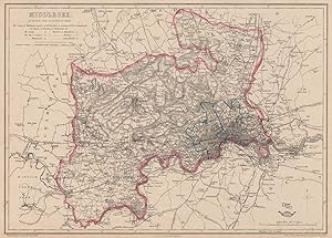
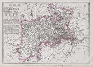
Middlesex
Erscheinungsdatum: 1863
Anbieter: Antiqua Print Gallery, London, Vereinigtes Königreich
Verkäuferbewertung 5 von 5 Sternen
Karte
EUR 12,41
EUR 11,47 Versand
Versand von Vereinigtes Königreich nach USAAnzahl: 2 verfügbar
In den WarenkorbZustand: Good. MIDDLESEX & LONDON PARISHES. Antique county map. Railways. BR DAVIES 1863. Antique map with original outline colour; Drawn & Engraved by B.R. Davies (1863). 31.5 x 43.5cm, 12.25 x 17.25 inches. Condition: Good. The image shown may have been taken from a different example of this map than that which is offered for sale. The map you will receive is in good condition but there may be minor variations in the condition from that shown in the image. This map was coloured by hand at the time of publication, thus the colouration may vary slightly between different examples of the map; the colouring applied to the map you receive may differ slightly from that shown in the image. There is nothing printed on the reverse side, which is plain.
-
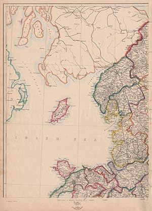
England & Wales, North-West sheet
Erscheinungsdatum: 1863
Anbieter: Antiqua Print Gallery, London, Vereinigtes Königreich
Verkäuferbewertung 5 von 5 Sternen
Karte
EUR 12,41
EUR 11,47 Versand
Versand von Vereinigtes Königreich nach USAAnzahl: 4 verfügbar
In den WarenkorbZustand: Good. ENGLAND & WALES NW. Cumbria Lancashire Welsh coast Isle of Man. WELLER 1863 map. Antique map with original outline colour; Engraved by B.R. Davies (1863). 45.5 x 32.5cm, 17.75 x 12.75 inches. Condition: Good. The image shown may have been taken from a different example of this map than that which is offered for sale. The map you will receive is in good condition but there may be minor variations in the condition from that shown in the image. This map was coloured by hand at the time of publication, thus the colouration may vary slightly between different examples of the map; the colouring applied to the map you receive may differ slightly from that shown in the image. There is nothing printed on the reverse side, which is plain.
-
Middlesex
Erscheinungsdatum: 1868
Anbieter: Antiqua Print Gallery, London, Vereinigtes Königreich
Verkäuferbewertung 5 von 5 Sternen
Karte
EUR 12,41
EUR 11,47 Versand
Versand von Vereinigtes Königreich nach USAAnzahl: 1 verfügbar
In den WarenkorbZustand: Fair. MIDDLESEX & LONDON PARISHES. Antique county map. Railways. BR DAVIES 1868. Antique map with original outline colour; Drawn & Engraved by B.R. Davies (1868). 31.5 x 43.5cm, 12.25 x 17.25 inches. Condition: Fair: Repaired tear in top margin extending into top border. The image shown may have been taken from a different example of this map than that which is offered for sale. Any flaws described in this statement may not be visible on the image but will be present on the map you receive. This map was coloured by hand at the time of publication, thus the colouration may vary slightly between different examples of the map; the colouring applied to the map you receive may differ slightly from that shown in the image. There is nothing printed on the reverse side, which is plain.
-
Middlesex
Erscheinungsdatum: 1868
Anbieter: Antiqua Print Gallery, London, Vereinigtes Königreich
Verkäuferbewertung 5 von 5 Sternen
Karte
EUR 12,41
EUR 11,47 Versand
Versand von Vereinigtes Königreich nach USAAnzahl: 1 verfügbar
In den WarenkorbZustand: Good. LONDON PARISHES & MIDDLESEX. Antique county map. Railways. BR DAVIES 1868. Antique map with original outline colour; Drawn & Engraved by B.R. Davies (1868). 31.5 x 43.5cm, 12.25 x 17.25 inches. Condition: Good. The image shown may have been taken from a different example of this map than that which is offered for sale. The map you will receive is in good condition but there may be minor variations in the condition from that shown in the image. This map was coloured by hand at the time of publication, thus the colouration may vary slightly between different examples of the map; the colouring applied to the map you receive may differ slightly from that shown in the image. There is nothing printed on the reverse side, which is plain.
-
Bedfordshire
Erscheinungsdatum: 1862
Anbieter: Antiqua Print Gallery, London, Vereinigtes Königreich
Verkäuferbewertung 5 von 5 Sternen
Karte
EUR 21,26
EUR 11,47 Versand
Versand von Vereinigtes Königreich nach USAAnzahl: 1 verfügbar
In den WarenkorbZustand: Fair. BEDFORDSHIRE. Antique county map. Railways canals. BR DAVIES 1862 old. Antique map with original outline colour; Drawn & Engraved by B.R. Davies (1862). 43.5 x 31.5cm, 17.25 x 12.5 inches. Condition: Fair: Spot. There is nothing printed on the reverse side, which is plain.
-
Bedfordshire
Erscheinungsdatum: 1863
Anbieter: Antiqua Print Gallery, London, Vereinigtes Königreich
Verkäuferbewertung 5 von 5 Sternen
Karte
EUR 21,26
EUR 11,47 Versand
Versand von Vereinigtes Königreich nach USAAnzahl: 1 verfügbar
In den WarenkorbZustand: Good. BEDFORDSHIRE. Antique county map. Railways canals. BR DAVIES 1863 old. Antique map with original outline colour; Drawn & Engraved by B.R. Davies (1863). 43.5 x 31.5cm, 17.25 x 12.5 inches. Condition: Good. The image shown may have been taken from a different example of this map than that which is offered for sale. The map you will receive is in good condition but there may be minor variations in the condition from that shown in the image. This map was coloured by hand at the time of publication, thus the colouration may vary slightly between different examples of the map; the colouring applied to the map you receive may differ slightly from that shown in the image. There is nothing printed on the reverse side, which is plain.
-
Buckinghamshire
Erscheinungsdatum: 1868
Anbieter: Antiqua Print Gallery, London, Vereinigtes Königreich
Verkäuferbewertung 5 von 5 Sternen
Karte
EUR 21,26
EUR 11,47 Versand
Versand von Vereinigtes Königreich nach USAAnzahl: 2 verfügbar
In den WarenkorbZustand: Good. BUCKINGHAMSHIRE. Antique county map. Railways canals. BR DAVIES 1868 old. Antique map with original outline colour; Drawn & Engraved by B.R. Davies (1868). 43.5 x 32.0cm, 17.25 x 12.5 inches. Condition: Good. The image shown may have been taken from a different example of this map than that which is offered for sale. The map you will receive is in good condition but there may be minor variations in the condition from that shown in the image. This map was coloured by hand at the time of publication, thus the colouration may vary slightly between different examples of the map; the colouring applied to the map you receive may differ slightly from that shown in the image. There is nothing printed on the reverse side, which is plain.
-
Surrey
Erscheinungsdatum: 1868
Anbieter: Antiqua Print Gallery, London, Vereinigtes Königreich
Verkäuferbewertung 5 von 5 Sternen
Karte
EUR 22,44
EUR 11,47 Versand
Versand von Vereinigtes Königreich nach USAAnzahl: 2 verfügbar
In den WarenkorbZustand: Good. SURREY. Chertsey Guildford Dorking. County map. Railways. BR DAVIES 1868. Antique map with original outline colour; Engraved by B.R. Davies (1868). 31.0 x 44.0cm, 12.25 x 17.25 inches. Condition: Good. The image shown may have been taken from a different example of this map than that which is offered for sale. The map you will receive is in good condition but there may be minor variations in the condition from that shown in the image. This map was coloured by hand at the time of publication, thus the colouration may vary slightly between different examples of the map; the colouring applied to the map you receive may differ slightly from that shown in the image. There is nothing printed on the reverse side, which is plain.
-
Berkshire
Erscheinungsdatum: 1864
Anbieter: Antiqua Print Gallery, London, Vereinigtes Königreich
Verkäuferbewertung 5 von 5 Sternen
Karte
EUR 24,80
EUR 11,47 Versand
Versand von Vereinigtes Königreich nach USAAnzahl: 1 verfügbar
In den WarenkorbZustand: Good. BERKSHIRE. Antique county map. Railways canals. BR DAVIES 1864 old. Antique map with original outline colour; Engraved by B.R. Davies (1864). 31.5 x 45.5cm, 12.5 x 18 inches. Condition: Good. The image shown may have been taken from a different example of this map than that which is offered for sale. The map you will receive is in good condition but there may be minor variations in the condition from that shown in the image. This map was coloured by hand at the time of publication, thus the colouration may vary slightly between different examples of the map; the colouring applied to the map you receive may differ slightly from that shown in the image. There is nothing printed on the reverse side, which is plain.
-
Sussex
Erscheinungsdatum: 1863
Anbieter: Antiqua Print Gallery, London, Vereinigtes Königreich
Verkäuferbewertung 5 von 5 Sternen
Karte
EUR 25,99
EUR 11,47 Versand
Versand von Vereinigtes Königreich nach USAAnzahl: 1 verfügbar
In den WarenkorbZustand: Good. SUSSEX antique county map. Chichester Rye Brighton Horsham. BR DAVIES 1863. Antique map with original outline colour; Engraved by B.R. Davies (1863). 31.5 x 44.5cm, 12.5 x 17.5 inches. Condition: Good. The image shown may have been taken from a different example of this map than that which is offered for sale. The map you will receive is in good condition but there may be minor variations in the condition from that shown in the image. This map was coloured by hand at the time of publication, thus the colouration may vary slightly between different examples of the map; the colouring applied to the map you receive may differ slightly from that shown in the image. There is nothing printed on the reverse side, which is plain.
-
Kent
Erscheinungsdatum: 1863
Anbieter: Antiqua Print Gallery, London, Vereinigtes Königreich
Verkäuferbewertung 5 von 5 Sternen
Karte
EUR 25,99
EUR 11,47 Versand
Versand von Vereinigtes Königreich nach USAAnzahl: 4 verfügbar
In den WarenkorbZustand: Good. KENT. County map. Downs. Railways in use/under construction. BR DAVIES 1863. Antique map with original outline colour; Engraved by B.R. Davies (1863). 31.0 x 43.0cm, 12.25 x 16.75 inches. Condition: Good. The image shown may have been taken from a different example of this map than that which is offered for sale. The map you will receive is in good condition but there may be minor variations in the condition from that shown in the image. This map was coloured by hand at the time of publication, thus the colouration may vary slightly between different examples of the map; the colouring applied to the map you receive may differ slightly from that shown in the image. There is nothing printed on the reverse side, which is plain.
-
Sussex
Erscheinungsdatum: 1863
Anbieter: Antiqua Print Gallery, London, Vereinigtes Königreich
Verkäuferbewertung 5 von 5 Sternen
Karte
EUR 25,99
EUR 11,47 Versand
Versand von Vereinigtes Königreich nach USAAnzahl: 2 verfügbar
In den WarenkorbZustand: Good. SUSSEX. Chichester Rye Brighton Horsham. County map.Railways.BR DAVIES 1863. Antique map with original outline colour; Engraved by B.R. Davies (1863). 31.5 x 44.5cm, 12.5 x 17.5 inches. Condition: Good. The image shown may have been taken from a different example of this map than that which is offered for sale. The map you will receive is in good condition but there may be minor variations in the condition from that shown in the image. This map was coloured by hand at the time of publication, thus the colouration may vary slightly between different examples of the map; the colouring applied to the map you receive may differ slightly from that shown in the image. There is nothing printed on the reverse side, which is plain.
-
Leeds
Anbieter: Antiqua Print Gallery, London, Vereinigtes Königreich
Verkäuferbewertung 5 von 5 Sternen
EUR 27,17
EUR 11,47 Versand
Versand von Vereinigtes Königreich nach USAAnzahl: 1 verfügbar
In den Warenkorb -
Oxfordshire
Erscheinungsdatum: 1868
Anbieter: Antiqua Print Gallery, London, Vereinigtes Königreich
Verkäuferbewertung 5 von 5 Sternen
Karte
EUR 31,89
EUR 11,47 Versand
Versand von Vereinigtes Königreich nach USAAnzahl: 1 verfügbar
In den WarenkorbZustand: Good. OXFORDSHIRE Antique county map. Railways Cotswolds Chilterns.BR DAVIES 1868. Antique map with original outline colour; Engraved by B.R. Davies (1868). 44.0 x 32.0cm, 17.25 x 12.5 inches. Condition: Good. The image shown may have been taken from a different example of this map than that which is offered for sale. The map you will receive is in good condition but there may be minor variations in the condition from that shown in the image. This map was coloured by hand at the time of publication, thus the colouration may vary slightly between different examples of the map; the colouring applied to the map you receive may differ slightly from that shown in the image. There is nothing printed on the reverse side, which is plain.
-
Leeds
Erscheinungsdatum: 1868
Anbieter: Antiqua Print Gallery, London, Vereinigtes Königreich
Verkäuferbewertung 5 von 5 Sternen
Karte
EUR 31,89
EUR 11,47 Versand
Versand von Vereinigtes Königreich nach USAAnzahl: 2 verfügbar
In den WarenkorbZustand: Good. LEEDS. Large town/city plan by BR DAVIES for the Dispatch Atlas 1868 old map. Antique map with original outline colour; Drawn & Engraved by B.R. Davies (1868). 32.0 x 43.0cm, 12.5 x 17 inches. Condition: Good. The image shown may have been taken from a different example of this map than that which is offered for sale. The map you will receive is in good condition but there may be minor variations in the condition from that shown in the image. This map was coloured by hand at the time of publication, thus the colouration may vary slightly between different examples of the map; the colouring applied to the map you receive may differ slightly from that shown in the image. There is nothing printed on the reverse side, which is plain.
-
Essex
Erscheinungsdatum: 1868
Anbieter: Antiqua Print Gallery, London, Vereinigtes Königreich
Verkäuferbewertung 5 von 5 Sternen
Karte
EUR 31,89
EUR 11,47 Versand
Versand von Vereinigtes Königreich nach USAAnzahl: 1 verfügbar
In den WarenkorbZustand: Good. ESSEX. Antique county map. Railways. BR DAVIES 1868 old plan chart. Antique map with original outline colour; Engraved by B.R. Davies (1868). 31.5 x 43.5cm, 12.25 x 17 inches. Condition: Good. The image shown may have been taken from a different example of this map than that which is offered for sale. The map you will receive is in good condition but there may be minor variations in the condition from that shown in the image. This map was coloured by hand at the time of publication, thus the colouration may vary slightly between different examples of the map; the colouring applied to the map you receive may differ slightly from that shown in the image. There is nothing printed on the reverse side, which is plain.
-
Hertfordshire
Erscheinungsdatum: 1868
Anbieter: Antiqua Print Gallery, London, Vereinigtes Königreich
Verkäuferbewertung 5 von 5 Sternen
Karte
EUR 31,89
EUR 11,47 Versand
Versand von Vereinigtes Königreich nach USAAnzahl: 1 verfügbar
In den WarenkorbZustand: Good. HERTFORDSHIRE antique county map. Shows 2 exclaves. Railways.BR DAVIES 1868. Antique map with original outline colour; Engraved by B.R. Davies (1868). 31.5 x 43.5cm, 12.25 x 17 inches. Condition: Good. The image shown may have been taken from a different example of this map than that which is offered for sale. The map you will receive is in good condition but there may be minor variations in the condition from that shown in the image. This map was coloured by hand at the time of publication, thus the colouration may vary slightly between different examples of the map; the colouring applied to the map you receive may differ slightly from that shown in the image. There is nothing printed on the reverse side, which is plain.
-
Manchester, and Salford
Erscheinungsdatum: 1862
Anbieter: Antiqua Print Gallery, London, Vereinigtes Königreich
Verkäuferbewertung 5 von 5 Sternen
Karte
EUR 38,98
EUR 11,47 Versand
Versand von Vereinigtes Königreich nach USAAnzahl: 1 verfügbar
In den WarenkorbZustand: Fair. MANCHESTER & SALFORD. Large town/city plan by BR DAVIES.Dispatch Atlas 1862 map. Antique map with original outline colour; Drawn & Engraved by B.R. Davies (1862). 32.5 x 43.5cm, 12.75 x 17.25 inches. Condition: Fair: Repaired tear in bottom margin extending c5mm inside the border of the map. Light spotting. There is nothing printed on the reverse side, which is plain.
-

Manchester, and Salford
Erscheinungsdatum: 1863
Anbieter: Antiqua Print Gallery, London, Vereinigtes Königreich
Verkäuferbewertung 5 von 5 Sternen
Karte
EUR 38,98
EUR 11,47 Versand
Versand von Vereinigtes Königreich nach USAAnzahl: 1 verfügbar
In den WarenkorbZustand: Fair. MANCHESTER & SALFORD. Large town/city plan by BR DAVIES.Dispatch Atlas 1863 map. Antique map with original outline colour; Drawn & Engraved by B.R. Davies (1863). 32.5 x 43.5cm, 12.75 x 17.25 inches. Condition: Fair: Weak impression. Blemishes. Repaired marginal tear. There is nothing printed on the reverse side, which is plain.
-
London and it's Environs. Containing the boundaries of the metropolitan boroughs, the different railroads & stations, the new cemeteries, roads, docks, canals, and all modern improvements.the whole corrected from personal observation & measurement.
Verlag: London C.F. Cheffins Wm. S. Orr & Co. Letts & Son J. Cross & Son and T.W. Saunders 1 December
Anbieter: Shapero Rare Books, London, Vereinigtes Königreich
Verbandsmitglied: ABA ILAB PBFA
Verkäuferbewertung 4 von 5 Sternen

Karte
EUR 885,87
EUR 17,20 Versand
Versand von Vereinigtes Königreich nach USAAnzahl: 1 verfügbar
In den WarenkorbFolding lithographed hand-coloured map, in 21 sections and laid on linen; small pinholes to corners. In original black/brown cloth, covers blocked in blind and lettered in gilt. Two inscriptions of Alfred Smith, dated 1864, to blank borders, inscription of George Epworth inside upper cover. 8vo (56 by 72cm opened). A handsome map drawn and engraved by Benjamin Rees Davies, lithographed from his 1843 map of the same title. Howgego 372 (6).
-
Manchester, and Salford
Erscheinungsdatum: 1868
Anbieter: Antiqua Print Gallery, London, Vereinigtes Königreich
Verkäuferbewertung 5 von 5 Sternen
Karte
EUR 48,43
EUR 11,47 Versand
Versand von Vereinigtes Königreich nach USAAnzahl: 1 verfügbar
In den WarenkorbZustand: Good. MANCHESTER & SALFORD. Large town/city plan by BR DAVIES.Dispatch Atlas 1868 map. Antique map with original outline colour; Drawn & Engraved by B.R. Davies (1868). 32.5 x 43.5cm, 12.75 x 17.25 inches. Condition: Good. The image shown may have been taken from a different example of this map than that which is offered for sale. The map you will receive is in good condition but there may be minor variations in the condition from that shown in the image. This map was coloured by hand at the time of publication, thus the colouration may vary slightly between different examples of the map; the colouring applied to the map you receive may differ slightly from that shown in the image. There is nothing printed on the reverse side, which is plain.
-

Davies`s New Map of the British Metropolis (=London). The Boundaries of the Borouchs, County Court Districts, Railways, and more modern Improvements.
Sprache: Deutsch
Verlag: London, Edward Stanford,, 1871
Anbieter: Die BÜCHERPOST, Hamburg, Deutschland
Verkäuferbewertung 5 von 5 Sternen
40 auf Leinen gezogene, fein gestochene Segmente, mehrfarbig. Sprache: Deutsch Gewicht in Gramm: 1100 Karte eingehängt in geprägte OLeinwand-Mappe mit vergoldeter Titelei. 980 x 965. Verschiedene Bibliotheksstempel im Innendeckel u. auf der Kartenrückseite. Sehr gut erhalten.
-
To the Queen: This Specimen of Graphic Ingenuity Being the Creed, the Lord's Prayer, the Ten Commandments . &c.
Verlag: Published . by the Engraver (B[enjamin]. R[ees]. Davies)., London., 1833
Anbieter: Sims Reed Ltd ABA ILAB, London, Vereinigtes Königreich
Verkäuferbewertung 5 von 5 Sternen
Karte
EUR 2.067,04
EUR 21,79 Versand
Versand von Vereinigtes Königreich nach USAAnzahl: 1 verfügbar
In den WarenkorbFolio. (295 x 197 mm). [2 leaves]. Steel engravings on laid India paper recto only, dedication, title, explanatory text &c. at foot of each. A stunning example of early miniature printing with the 'Creed, the Lord's Prayer' etc. engraved and printed to the size of an early nineteenth-century silver penny together with the additional key plate. The first engraving, a remarkable and inventive tour-de-force of steel engraving, features a central engraved circle which when examined closely proves to be text. Surrounded by clouds or smoke and emanating rays of light, with a dove above and suitably religious imagery beneath (a crucifix, Moses' tablets, an incense burner, a grail, crown of thorns, hammer and nails, a serpent and so on), the text proves to be - as the explanatory legend beneath indicates - the 'Creed, the Lord's Prayer, the Ten Commandments, General Thanksgiving Prayer, the Evening Collect, Grace, &c. &c. The second engraving, a larger central circular section of text surrounded by emanating rays, provides a transcription of the text of the first: 'Containing the same words in each line as the one engraved within the compass of a silver penny'. As noted beneath, this second engraving is 'given as a key with the proofs of the minute writing'. Dedicated by the engraver Davies 'to the Queen' (i.e. William IV's Queen, Adelaide of Saxe-Meiningen), it seems likely that Davies sought Royal patronage for his work as a printer. Known in particular as a printer and publisher, in particular of maps, Davies was an early adopter of steel engraving, a technique that allowed particularly fine and detailed engraving due to the hardness of the surface of the plate. Miniature engraving, in particular of religious texts, developed as a method for the display of the skill of the engraver. This example, the engraving as per the key plate was completed in March 1833, was executed at an early date and is both particularly fine and exceptionally ambitious; other undertakings are larger or feature the Lord's Prayer or the Ten Commandments only.
-
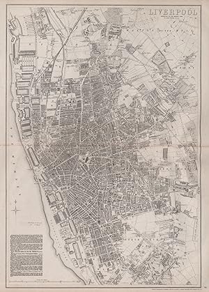
Liverpool
Erscheinungsdatum: 1868
Anbieter: Antiqua Print Gallery, London, Vereinigtes Königreich
Verkäuferbewertung 5 von 5 Sternen
Karte
EUR 106,30
EUR 11,47 Versand
Versand von Vereinigtes Königreich nach USAAnzahl: 1 verfügbar
In den WarenkorbZustand: Good. LIVERPOOL. Large town/city plan by BR DAVIES for the Dispatch Atlas 1868 map. Antique map with original outline colour; Drawn & Engraved by B.R. Davies (1868). 65.0 x 44.5cm, 25.5 x 17.5 inches; this is a folding map. Condition: Good. The image shown may have been taken from a different example of this map than that which is offered for sale. The map you will receive is in good condition but there may be minor variations in the condition from that shown in the image. This map was coloured by hand at the time of publication, thus the colouration may vary slightly between different examples of the map; the colouring applied to the map you receive may differ slightly from that shown in the image. There is nothing printed on the reverse side, which is plain.
-
Plan of Paris, and the surrounding communes, shewing the fortifications and all modern improvements
Erscheinungsdatum: 1863
Anbieter: Antiqua Print Gallery, London, Vereinigtes Königreich
Verkäuferbewertung 5 von 5 Sternen
Karte
EUR 124,02
EUR 11,47 Versand
Versand von Vereinigtes Königreich nach USAAnzahl: 1 verfügbar
In den WarenkorbZustand: Good. PLAN OF PARIS & SURROUNDING COMMUNES. Fortifications. BR DAVIES 1863 old map. Antique map with original outline colour; Drawn & Engraved by J.W. Lowry (1863). 63.5 x 45.5cm, 25 x 18 inches. Condition: Good. The image shown may have been taken from a different example of this map than that which is offered for sale. The map you will receive is in good condition but there may be minor variations in the condition from that shown in the image. This map was coloured by hand at the time of publication, thus the colouration may vary slightly between different examples of the map; the colouring applied to the map you receive may differ slightly from that shown in the image. There is nothing printed on the reverse side, which is plain.
-

Davies's Map of the British Metropolis. The Boundaries of the Boroughs, County Court Districts, Railways and Modern Improvements.
Erscheinungsdatum: 1860
Anbieter: Altea Antique Maps, London, Vereinigtes Königreich
Verbandsmitglied: ABA ILAB PBFA
Verkäuferbewertung 5 von 5 Sternen
Karte
EUR 1.535,51
EUR 40,14 Versand
Versand von Vereinigtes Königreich nach USAAnzahl: 1 verfügbar
In den WarenkorbLondon: Edward Stanford, c.1850. Original colour. Dissected and laid on linen, total 670 x 965mm. A large and detailed map, covering from Hammersmith clockwise to Willesden, Highgate, Leytonstone, Canning Town, Greenwich, Bromley, Mitcham, Wimbledon and Barnes. A ring marks 4 miles from Charing Cross. The map is undated, but as Brunel's Hungerford Suspension Bridge is still in place and King's Cross Station is marked we estimate it c.1852. HYDE: 27.