
Gesamtpreis (1 Artikel Artikel):
Versandziel:

darkes giles (32 Ergebnisse)
Direkt zu den wichtigsten Suchergebnissen
Suchfilter
Produktart
- Alle Product Types
- Bücher (25)
- Magazine & Zeitschriften (Keine weiteren Ergebnisse entsprechen dieser Verfeinerung)
- Comics (Keine weiteren Ergebnisse entsprechen dieser Verfeinerung)
- Noten (Keine weiteren Ergebnisse entsprechen dieser Verfeinerung)
- Kunst, Grafik & Poster (Keine weiteren Ergebnisse entsprechen dieser Verfeinerung)
- Fotografien (Keine weiteren Ergebnisse entsprechen dieser Verfeinerung)
- Karten (7)
- Manuskripte & Papierantiquitäten (Keine weiteren Ergebnisse entsprechen dieser Verfeinerung)
Zustand Mehr dazu
- Neu (23)
- Wie Neu, Sehr Gut oder Gut Bis Sehr Gut (Keine weiteren Ergebnisse entsprechen dieser Verfeinerung)
- Gut oder Befriedigend (4)
- Ausreichend oder Schlecht (Keine weiteren Ergebnisse entsprechen dieser Verfeinerung)
- Wie beschrieben (5)
Einband
- alle Einbände
- Hardcover (Keine weiteren Ergebnisse entsprechen dieser Verfeinerung)
- Softcover (9)
Weitere Eigenschaften
- Erstausgabe (2)
- Signiert (Keine weiteren Ergebnisse entsprechen dieser Verfeinerung)
- Schutzumschlag (Keine weiteren Ergebnisse entsprechen dieser Verfeinerung)
- Angebotsfoto (11)
Sprache (3)
Gratisversand
Land des Verkäufers
Verkäuferbewertung
-

An Historical Map of Canterbury from medieval times to 1907
Anbieter: PBShop.store UK, Fairford, GLOS, Vereinigtes Königreich
Verkäuferbewertung 4 von 5 Sternen

EUR 11,72
EUR 3,77 Versand
Versand von Vereinigtes Königreich nach USAAnzahl: 15 verfügbar
In den WarenkorbUNK. Zustand: New. New Book. Shipped from UK. Established seller since 2000.
-
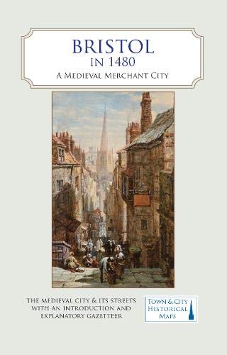
Bristol in 1480
Anbieter: PBShop.store UK, Fairford, GLOS, Vereinigtes Königreich
Verkäuferbewertung 5 von 5 Sternen

EUR 11,96
EUR 3,77 Versand
Versand von Vereinigtes Königreich nach USAAnzahl: 15 verfügbar
In den WarenkorbUNK. Zustand: New. New Book. Shipped from UK. Established seller since 2000.
-
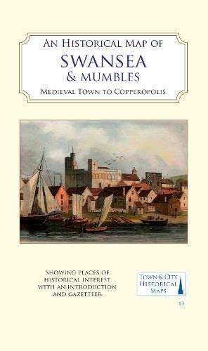
An Historical Map of Swansea and Mumbles
Anbieter: PBShop.store UK, Fairford, GLOS, Vereinigtes Königreich
Verkäuferbewertung 5 von 5 Sternen
EUR 12,67
EUR 3,77 Versand
Versand von Vereinigtes Königreich nach USAAnzahl: 15 verfügbar
In den WarenkorbUNK. Zustand: New. New Book. Shipped from UK. Established seller since 2000.
-

An Historical Map of Coventry
Anbieter: PBShop.store UK, Fairford, GLOS, Vereinigtes Königreich
Verkäuferbewertung 4 von 5 Sternen
EUR 12,96
EUR 3,77 Versand
Versand von Vereinigtes Königreich nach USAAnzahl: 15 verfügbar
In den WarenkorbUNK. Zustand: New. New Book. Shipped from UK. Established seller since 2000.
-

An Historical Map of York
Anbieter: PBShop.store UK, Fairford, GLOS, Vereinigtes Königreich
Verkäuferbewertung 5 von 5 Sternen
EUR 13,39
EUR 3,77 Versand
Versand von Vereinigtes Königreich nach USAAnzahl: 15 verfügbar
In den WarenkorbUNK. Zustand: New. New Book. Shipped from UK. Established seller since 2000.
-
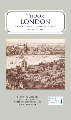
A Map of Tudor London
Anbieter: PBShop.store UK, Fairford, GLOS, Vereinigtes Königreich
Verkäuferbewertung 5 von 5 Sternen
EUR 13,39
EUR 3,77 Versand
Versand von Vereinigtes Königreich nach USAAnzahl: 15 verfügbar
In den WarenkorbUNK. Zustand: New. New Book. Shipped from UK. Established seller since 2000.
-
An Historical Map of Coventry: From Medieval to Industrial City
Anbieter: Revaluation Books, Exeter, Vereinigtes Königreich
Verkäuferbewertung 5 von 5 Sternen
Karte
EUR 10,10
EUR 11,46 Versand
Versand von Vereinigtes Königreich nach USAAnzahl: 2 verfügbar
In den WarenkorbMap. Zustand: Brand New. 2 pages. 8.90x5.28x0.39 inches. In Stock.
-

An Historical Map of Oxford: From Medieval to Victorian Times NEW EDITION
Anbieter: Revaluation Books, Exeter, Vereinigtes Königreich
Verkäuferbewertung 5 von 5 Sternen
Karte
EUR 10,51
EUR 11,46 Versand
Versand von Vereinigtes Königreich nach USAAnzahl: 2 verfügbar
In den WarenkorbMap. Zustand: Brand New. 2nd edition. 2 pages. 8.94x5.28x0.51 inches. In Stock.
-
A Map of Tudor London
Anbieter: Majestic Books, Hounslow, Vereinigtes Königreich
Verkäuferbewertung 4 von 5 Sternen
EUR 15,70
EUR 7,45 Versand
Versand von Vereinigtes Königreich nach USAAnzahl: 3 verfügbar
In den WarenkorbZustand: New.
-
Historical Map Of York: From Medieval Times To 1850
Anbieter: Revaluation Books, Exeter, Vereinigtes Königreich
Verkäuferbewertung 5 von 5 Sternen
Karte
EUR 12,72
EUR 11,46 Versand
Versand von Vereinigtes Königreich nach USAAnzahl: 2 verfügbar
In den WarenkorbSheet Map, Flat. Zustand: Brand New. 2 pages. 8.94x5.28x0.59 inches. In Stock.
-
A Map of Tudor London: The City and Southwark in 1520. Second edition
Anbieter: Revaluation Books, Exeter, Vereinigtes Königreich
Verkäuferbewertung 5 von 5 Sternen
Karte
EUR 14,16
EUR 11,46 Versand
Versand von Vereinigtes Königreich nach USAAnzahl: 1 verfügbar
In den WarenkorbMap. Zustand: Brand New. revised edition. 2 pages. 8.98x5.24x0.91 inches. In Stock.
-

Cartography: an introduction
Sprache: Englisch
Verlag: British Cartographic Society, United Kingdom, London, 2017
ISBN 10: 0904482251 ISBN 13: 9780904482256
Anbieter: WorldofBooks, Goring-By-Sea, WS, Vereinigtes Königreich
Verkäuferbewertung 5 von 5 Sternen
EUR 28,67
EUR 6,42 Versand
Versand von Vereinigtes Königreich nach USAAnzahl: 7 verfügbar
In den WarenkorbPaperback. Zustand: Very Good. The book has been read, but is in excellent condition. Pages are intact and not marred by notes or highlighting. The spine remains undamaged.
-

A map of Tudor London : England's greatest city in 1520
Verlag: Oxford : British Historic Towns Atlas
Erstausgabe
1st edition. Series: Town & city historical maps. Physical description: 1 map : colour ; 87 x 128 cm, folded to 24 x 14 cm. Subjects: London History 2018; Maps; Geography; Tudor England. 1 Kg. Item is Shipped from Ireland or US locations.
-

An historical map of Beverley, medieval, Georgian & Victorian town.
Verlag: Historic Towns Trust 2022.; Folding col map (c.85x100cm)., 2022
Anbieter: Bennett and Kerr Books, ABINGDON, Vereinigtes Königreich
Verkäuferbewertung 5 von 5 Sternen
EUR 11,81
EUR 18,34 Versand
Versand von Vereinigtes Königreich nach USAAnzahl: 1 verfügbar
In den WarenkorbPaperback. Pictorial card covers. New. Gazetteer & illus on reverse. Historic Towns - Beverley.
-
Historical maps of Alnwick & Alnmouth from earliest times to 1918.
Verlag: Historic Towns Trust 2021.; Folding col map (c.85x100cm), illus on reverse., 2021
Anbieter: Bennett and Kerr Books, ABINGDON, Vereinigtes Königreich
Verkäuferbewertung 5 von 5 Sternen
EUR 11,81
EUR 18,34 Versand
Versand von Vereinigtes Königreich nach USAAnzahl: 1 verfügbar
In den WarenkorbPaperback. Pictorial card covers. New. Gazetteer & map of Alnmouth on reverse. Historic Towns - Alnwick.
-
An Historical Map of Coventry: From Medieval to Industrial City
Anbieter: Ria Christie Collections, Uxbridge, Vereinigtes Königreich
Verkäuferbewertung 5 von 5 Sternen
EUR 14,10
EUR 13,73 Versand
Versand von Vereinigtes Königreich nach USAAnzahl: Mehr als 20 verfügbar
In den WarenkorbZustand: New. In.
-
An Historical Map of York: From Medieval Times to 1850 (Town & City Historical Maps)
Anbieter: Ria Christie Collections, Uxbridge, Vereinigtes Königreich
Verkäuferbewertung 5 von 5 Sternen
EUR 14,25
EUR 13,73 Versand
Versand von Vereinigtes Königreich nach USAAnzahl: Mehr als 20 verfügbar
In den WarenkorbZustand: New. In.
-
Tudor London: the City and Southwark in 1520. Second edition.
Verlag: Historic Towns Trust 2018 2nd edn 2022.; Large folding col map (85x125cm)., 2022
Anbieter: Bennett and Kerr Books, ABINGDON, Vereinigtes Königreich
Verkäuferbewertung 5 von 5 Sternen
EUR 14,17
EUR 18,34 Versand
Versand von Vereinigtes Königreich nach USAAnzahl: 1 verfügbar
In den WarenkorbPaperback. Pictorial card covers. New. On reverse a map of London's Wards in 1520, a directory of street and building names, & an intr to London's topographical history. Historic Towns - London, Tudor.
-

Cartography: An Introduction
Sprache: Englisch
Verlag: British Cartographic Society, 2008
ISBN 10: 0904482235 ISBN 13: 9780904482232
Anbieter: Anybook.com, Lincoln, Vereinigtes Königreich
Verkäuferbewertung 5 von 5 Sternen
EUR 33,41
EUR 15,36 Versand
Versand von Vereinigtes Königreich nach USAAnzahl: 1 verfügbar
In den WarenkorbZustand: Good. This is an ex-library book and may have the usual library/used-book markings inside.This book has soft covers. In good all round condition. Library sticker on front cover. Please note the Image in this listing is a stock photo and may not match the covers of the actual item,150grams, ISBN:9780904482232.
-
An Historical Atlas of Oxfordshire book by Kate Tiller, Giles Darkes
Sprache: Englisch
Verlag: Oxfordshire Record Society, 2010
ISBN 10: 0902509632 ISBN 13: 9780902509634
Anbieter: West Cove UK, Wellington, Vereinigtes Königreich
Verkäuferbewertung 5 von 5 Sternen
EUR 30,35
EUR 29,75 Versand
Versand von Vereinigtes Königreich nach USAAnzahl: 1 verfügbar
In den WarenkorbSoftcover. Zustand: Very Good. Immediate dispatch from Somerset. Nice book in great condition. Pages in excellent condition. Softcover. English. See images for condition. About the book >.>.> One of the great pleasures of being Lord Lieutenant is the chance of getting to know Oxfordshire even better. From the rural calm of the Cotswolds, to the busy streets of Oxford; from ancient monuments to hi-tech companies: the 1600 square miles of the county encompass a huge variety of people and places. On every visit I make, I learn something new and discover something different. Looking through An Historical Atlas of Oxfordshire is like taking a tour round the county with a remarkably knowledgeable friend. Every page yields some new insight or reveals a new fact. It is full of fascinating details. As a whole it suggests key patterns of change and continuity in the county. Having read it, I will never see Oxfordshire in quite the same light again. Certainly, I feel I now know it even better than I could ever have imagined before. Anyone who loves Oxfordshire, and all those who have any connection with the county, owe Dr Kate Tiller and her contributors a real debt of grat-itude. This has clearly been a labour o.
-

Karte/Landkarte. Zustand: New. KlappentextrnrnA full colour map based on a digitising of a large-scale map of York surveyed in 1850. The map shows the main medieval and post-medieval buildings in this attractive and interesting city including the Minster , York Castle (Cliff.
-

An Historical Atlas of Oxfordshire
Sprache: Englisch
Verlag: Oxfordshire Record Society, 2010
ISBN 10: 0902509632 ISBN 13: 9780902509634
Anbieter: April House Books, Chipping Norton, Vereinigtes Königreich
Verkäuferbewertung 5 von 5 Sternen
Erstausgabe
EUR 35,42
EUR 33,23 Versand
Versand von Vereinigtes Königreich nach USAAnzahl: 1 verfügbar
In den WarenkorbSoft cover. Zustand: Very Good. 1st Edition. **PLEASE NOTE** that there may be a surcharge to pay for international postage (at cost) on this item: we'll advise you of the amount when you order, and you will have the option of accepting or cancelling at that point.
-

Zustand: New. KlappentextrnrnA full colour map showing London in about 1520 - its many churches, monasteries, legal inns, guild halls, and a large number of substantial private houses, in the context of the streets and alleyways that survived the Great Fire a.
-

Bristol in 1480 : A Medieval Merchant City
Sprache: Englisch
Verlag: The Historic Towns Trust Jan 2021, 2021
ISBN 10: 0993469876 ISBN 13: 9780993469879
Anbieter: AHA-BUCH GmbH, Einbeck, Deutschland
Verkäuferbewertung 5 von 5 Sternen
Karte. Zustand: Neu. Neuware - A full colour map, where the city in about 1480 is shown against a background of a detailed Ordnance Survey of the early 20th century. Produced in association with the University of Bristol.
-

An Historical Map of Swansea & Mumbles : medieval town to Copperopolis
Sprache: Englisch
Verlag: The Historic Towns Trust Apr 2023, 2023
ISBN 10: 183807192X ISBN 13: 9781838071929
Anbieter: AHA-BUCH GmbH, Einbeck, Deutschland
Verkäuferbewertung 5 von 5 Sternen
Karte. Zustand: Neu. Neuware - A full colour map, based on digitised OS maps of Swansea of about 1919, with its medieval past overlain and important buildings picked out. The map includes an inset map of Mumbles and its medieval castle.
-

An Historical Map of York : From Medieval Times to 1850
Sprache: Englisch
Verlag: The Historic Towns Trust Jun 2018, 2018
ISBN 10: 0993469841 ISBN 13: 9780993469848
Anbieter: AHA-BUCH GmbH, Einbeck, Deutschland
Verkäuferbewertung 5 von 5 Sternen
Karte. Zustand: Neu. Neuware - A full colour map based on a digitising of a large-scale map of York surveyed in 1850. The map shows the main medieval and post-medieval buildings in this attractive and interesting city including the Minster , York Castle (Clifford's Tower), St mary's Abbey and the well-known city walls.
-
HISTORICAL MAP OF YORK
Anbieter: Speedyhen, Hertfordshire, Vereinigtes Königreich
Verkäuferbewertung 5 von 5 Sternen
EUR 13,30
EUR 47,00 Versand
Versand von Vereinigtes Königreich nach USAAnzahl: 2 verfügbar
In den WarenkorbZustand: NEW.
-

(Land-)Karte. Zustand: Neu. An Historical Map of Swansea & Mumbles | medieval town to Copperopolis | Giles Darkes (u. a.) | (Land-)Karte | Karte/Landkarte | Englisch | 2023 | The Historic Towns Trust | EAN 9781838071929 | Verantwortliche Person für die EU: Libri GmbH, Europaallee 1, 36244 Bad Hersfeld, gpsr[at]libri[dot]de | Anbieter: preigu.
-

(Land-)Karte. Zustand: Neu. Bristol in 1480 | A Medieval Merchant City | Giles Darkes (u. a.) | (Land-)Karte | Karte/Landkarte | Englisch | 2021 | The Historic Towns Trust | EAN 9780993469879 | Verantwortliche Person für die EU: Libri GmbH, Europaallee 1, 36244 Bad Hersfeld, gpsr[at]libri[dot]de | Anbieter: preigu.
-

(Land-)Karte. Zustand: Neu. An Historical Map of York | From Medieval Times to 1850 | Giles Darkes (u. a.) | (Land-)Karte | Town & City Historical Maps | Karte/Landkarte | Englisch | 2018 | The Historic Towns Trust | EAN 9780993469848 | Verantwortliche Person für die EU: Libri GmbH, Europaallee 1, 36244 Bad Hersfeld, gpsr[at]libri[dot]de | Anbieter: preigu.

