Gesamtpreis (1 Artikel Artikel):
Versandziel:

covens mortier (171 Ergebnisse)
Direkt zu den wichtigsten Suchergebnissen
Suchfilter
Produktart
- Alle Product Types
- Bücher (56)
- Magazine & Zeitschriften (Keine weiteren Ergebnisse entsprechen dieser Verfeinerung)
- Comics (Keine weiteren Ergebnisse entsprechen dieser Verfeinerung)
- Noten (Keine weiteren Ergebnisse entsprechen dieser Verfeinerung)
- Kunst, Grafik & Poster (31)
- Fotografien (Keine weiteren Ergebnisse entsprechen dieser Verfeinerung)
- Karten (84)
- Manuskripte & Papierantiquitäten (Keine weiteren Ergebnisse entsprechen dieser Verfeinerung)
Zustand Mehr dazu
- Neu (Keine weiteren Ergebnisse entsprechen dieser Verfeinerung)
- Wie Neu, Sehr Gut oder Gut Bis Sehr Gut (7)
- Gut oder Befriedigend (29)
- Ausreichend oder Schlecht (Keine weiteren Ergebnisse entsprechen dieser Verfeinerung)
- Wie beschrieben (135)
Einband
Weitere Eigenschaften
- Erstausgabe (4)
- Signiert (1)
- Schutzumschlag (Keine weiteren Ergebnisse entsprechen dieser Verfeinerung)
- Angebotsfoto (158)
Sprache (4)
Gratisversand
Land des Verkäufers
Verkäuferbewertung
-

"Carte du Royaume de Danemarc" - Denmark Dänemark Danmark Sverige Schweden Sweden Holstein
Sprache: Französisch
Verlag: Amsterdam, Covens & Mortier ca. 1780., 1780
Anbieter: Antiquariat Steffen Völkel GmbH, Seubersdorf, Deutschland
Verkäuferbewertung 5 von 5 Sternen

Karte
Blatt-Maße: ca. 53 x 66 cm. -- Altkolorierte Kupferstich-Karte. -- gut erhalten. || Old colored engraved map. -- in good condition. // Wir, das Antiquariat Steffen Völkel, kaufen und verkaufen alte Bücher, Handschriften, Zeichnungen, Autographen, Grafiken und Fotografien. Wir sind stets am Ankauf von kompletten Bibliotheken, Sammlungen und Nachlässen interessiert. Sprache: Französisch Gewicht in Gramm: 30.
-

"Partie meridionale de la Souabe" - Schwaben Augsburg Kempten Memmingen Bodensee Ulm Kaufbeuren Biberach Bodensee Allgäu Ehingen Leutkirch Günzburg Blaubeuren Lindau Füssen Landsberg Mindelheim Baden-Württemberg Bayern
Sprache: Französisch
Verlag: Amsterdam, Covens & Mortier um 1750., 1750
Anbieter: Antiquariat Steffen Völkel GmbH, Seubersdorf, Deutschland
Verkäuferbewertung 5 von 5 Sternen
Karte
Blatt-Maße: ca. 53 x 66 cm. -- Altkolorierte Kupferstich-Karte. -- gut erhalten. || Old colored engraved map. -- in good condition. // Wir, das Antiquariat Steffen Völkel, kaufen und verkaufen alte Bücher, Handschriften, Zeichnungen, Autographen, Grafiken und Fotografien. Wir sind stets am Ankauf von kompletten Bibliotheken, Sammlungen und Nachlässen interessiert. Sprache: Französisch Gewicht in Gramm: 30.
-

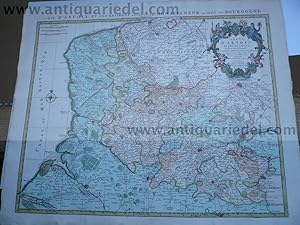
"Partie septentrionale du Duche de Bourgogne" - Bourgogne Tonnerre Auxerre Langres Dijon Auxonne / France Frankreich
Sprache: Französisch
Verlag: Amsterdam, Covens & Mortier um 1750., 1750
Anbieter: Antiquariat Steffen Völkel GmbH, Seubersdorf, Deutschland
Verkäuferbewertung 5 von 5 Sternen
Karte
Blatt-Maße: ca. 53 x 66 cm. -- Altkolorierte Kupferstich-Karte. -- am oberen Außenrand teils leicht fleckig, sonst gut erhalten. || Old colored engraved map. -- slightly stained on the upper outer margin, otherwise in good condition. // Wir, das Antiquariat Steffen Völkel, kaufen und verkaufen alte Bücher, Handschriften, Zeichnungen, Autographen, Grafiken und Fotografien. Wir sind stets am Ankauf von kompletten Bibliotheken, Sammlungen und Nachlässen interessiert. Sprache: Französisch Gewicht in Gramm: 30.
-

"Carte des provinces du Maine et du Perche dans la quelle se trouve comprise la Partie Septentrionale de la Generalité de Tours" - Maine Perche Nogent Mayenne Laval le Mans Seez / France Frankreich
Sprache: Französisch
Verlag: Amsterdam, Covens & Mortier um 1750., 1750
Anbieter: Antiquariat Steffen Völkel GmbH, Seubersdorf, Deutschland
Verkäuferbewertung 5 von 5 Sternen
Karte
Blatt-Maße: ca. 53 x 77 cm. -- Altkolorierte Kupferstich-Karte.Von 2 Platten gedruckt. -- gut erhalten. || Old colored engraved map. Printed on two plates. -- in good condition. // Wir, das Antiquariat Steffen Völkel, kaufen und verkaufen alte Bücher, Handschriften, Zeichnungen, Autographen, Grafiken und Fotografien. Wir sind stets am Ankauf von kompletten Bibliotheken, Sammlungen und Nachlässen interessiert. Sprache: Französisch Gewicht in Gramm: 30.
-

"Carte de la Champagne et des Pays Voisins ou l'on voit la Generalite de Chalons, partie de celle de Soissons &c" - Champagne Chalons Soissons Verdun Laon Guise Reims Compiegne Givet Noyon / France Frankreich
Sprache: Französisch
Verlag: Amsterdam, Covens & Mortier um 1750., 1750
Anbieter: Antiquariat Steffen Völkel GmbH, Seubersdorf, Deutschland
Verkäuferbewertung 5 von 5 Sternen
Karte
Blatt-Maße: ca. 53 x 66 cm. -- Altkolorierte Kupferstich-Karte. -- gut erhalten. || Old colored engraved map. -- in good condition. // Wir, das Antiquariat Steffen Völkel, kaufen und verkaufen alte Bücher, Handschriften, Zeichnungen, Autographen, Grafiken und Fotografien. Wir sind stets am Ankauf von kompletten Bibliotheken, Sammlungen und Nachlässen interessiert. Sprache: Französisch Gewicht in Gramm: 30.
-

"Partie septentrionale de la Souabe" - Schwaben Nördlingen Ansbach Rottenburg Schwäbisch Hall Crailsheim Gaildorf Bopfingen Donauwörth Schwäbisch Gmünd Schorndorf Bad Wimpfen Heilbronn Giengen Nürnberg
Sprache: Französisch
Verlag: Amsterdam, Covens & Mortier um 1750., 1750
Anbieter: Antiquariat Steffen Völkel GmbH, Seubersdorf, Deutschland
Verkäuferbewertung 5 von 5 Sternen
Karte
Blatt-Maße: ca. 53 x 66 cm. -- Altkolorierte Kupferstich-Karte. -- gut erhalten. || Old colored engraved map. -- in good condition. // Wir, das Antiquariat Steffen Völkel, kaufen und verkaufen alte Bücher, Handschriften, Zeichnungen, Autographen, Grafiken und Fotografien. Wir sind stets am Ankauf von kompletten Bibliotheken, Sammlungen und Nachlässen interessiert. Sprache: Französisch Gewicht in Gramm: 30.
-

"Carte particuliere d Anjou et de Touraine ou de la Partie Meridionale de la Generalité de Tours." - Angers Loudon Amboise Saumur Vendome Loches map Karte Covens Mortier
Sprache: Französisch
Verlag: Amsterdam, Covens & Mortier ca. 1750., 1750
Anbieter: Antiquariat Steffen Völkel GmbH, Seubersdorf, Deutschland
Verkäuferbewertung 5 von 5 Sternen
Karte
Blatt-Maße: ca. 53 x 77 cm. -- Altkolorierte Kupferstich-Karte. Von 2 Platten gedruckt. -- gut erhalten. || Old colored engraved map. Printed on two plates. -- in good condition. // Wir, das Antiquariat Steffen Völkel, kaufen und verkaufen alte Bücher, Handschriften, Zeichnungen, Autographen, Grafiken und Fotografien. Wir sind stets am Ankauf von kompletten Bibliotheken, Sammlungen und Nachlässen interessiert. Sprache: Französisch Gewicht in Gramm: 25.
-

"Partie Meridionale du Duche de Bourgogne" - Bourgogne Macon Beaune Chalon-sur-Saone Autun / France Frankreich
Sprache: Französisch
Verlag: Amsterdam, Covens & Mortier um 1750., 1750
Anbieter: Antiquariat Steffen Völkel GmbH, Seubersdorf, Deutschland
Verkäuferbewertung 5 von 5 Sternen
Karte
Blatt-Maße: ca. 53 x 66 cm. -- Altkolorierte Kupferstich-Karte. -- gut erhalten. || Old colored engraved map. -- in good condition. // Wir, das Antiquariat Steffen Völkel, kaufen und verkaufen alte Bücher, Handschriften, Zeichnungen, Autographen, Grafiken und Fotografien. Wir sind stets am Ankauf von kompletten Bibliotheken, Sammlungen und Nachlässen interessiert. Sprache: Französisch Gewicht in Gramm: 30.
-

"Partie meridionale de Picardie" - Amiens Corbie Beauvais Abbeville Ham / France Frankreich
Sprache: Französisch
Verlag: Amsterdam, Covens & Mortier um 1730., 1730
Anbieter: Antiquariat Steffen Völkel GmbH, Seubersdorf, Deutschland
Verkäuferbewertung 5 von 5 Sternen
Karte
Blatt-Maße: ca. 53 x 66 cm. -- Altkolorierte Kupferstich-Karte. -- gut erhalten. || Old colored engraved map. -- in good condition. // Wir, das Antiquariat Steffen Völkel, kaufen und verkaufen alte Bücher, Handschriften, Zeichnungen, Autographen, Grafiken und Fotografien. Wir sind stets am Ankauf von kompletten Bibliotheken, Sammlungen und Nachlässen interessiert. Sprache: Französisch Gewicht in Gramm: 30.
-
Diocese of Toul, Lorraine, anno 1745, map by Covens & Mortier
Verlag: Covens & Mortier
Anbieter: Hammelburger Antiquariat, Hammelburg, Deutschland
Verkäuferbewertung 5 von 5 Sternen
Hardcover. Zustand: very good. Diocese of Toul, Lorraine, anno 1745, map by Covens & Mortier Publisher: COVENS, J. / MORTIER, C. Title: Civitas Leucorum sive Pagus Tullensis aujourdhui Le Diocese De Toul . . Published: Amsterdam circa anno 1745 49.0 x 58.0 cm. Original contemporary coloured,printed on thick paper, slightly age-toned. Good impression. Excellent condition. Highly detailed map of the Diocese of Toul, centered on the cities of Nancy and Toul and including Metz, Verdun, S. Dizier, Nas, Neufchatel, Mircourt, Remiremont, Pagi, etc. Shows towns, castles, churches, roads, rivers, lakes, mountains, etc. 2 decorative cartouches.
-

"Le Gouvernement general de Languedoc, Partie Occidentale divise en trois lieutenances generales scavoir la Haut Languedoc, la Bas Languedoc et les sevennes subdivisees en toute ses parties, levee sur les Lieux." - Languedoc Toulouse Montauban Alby Cahors Albi Agen
Sprache: Deutsch
Verlag: Amsterdam, Covens & Mortier um 1750., 1750
Anbieter: Antiquariat Steffen Völkel GmbH, Seubersdorf, Deutschland
Verkäuferbewertung 5 von 5 Sternen
Karte
Blatt-Maße: ca. 66 x 53 cm. -- Altkolorierte Kupferstich-Karte. -- gut erhalten. || Old colored engraved map. -- in good condition. // Wir, das Antiquariat Steffen Völkel, kaufen und verkaufen alte Bücher, Handschriften, Zeichnungen, Autographen, Grafiken und Fotografien. Wir sind stets am Ankauf von kompletten Bibliotheken, Sammlungen und Nachlässen interessiert. Sprache: Deutsch Gewicht in Gramm: 30.
-
Artois, map, anno 1745, Covens & Mortier, fine print
Verlag: Covens & Mortier
Anbieter: Hammelburger Antiquariat, Hammelburg, Deutschland
Verkäuferbewertung 5 von 5 Sternen
Karte
Hardcover. Zustand: Gut. Artois, map, anno 1745, Covens & Mortier, fine print, printed on thick paper, little brownish, small tears on margins Publisher: COVENS, J. / MORTIER, C. Title: Carte D'Artois ET Des Environs. Published: Amsterdam c. 1745 Size: 50.0 x 60.0 cm. Colouring: In original colours. Condition: Printed on thick paper. Very good condition. Topographically detailed regional map of the Artois region in northern France. The map extends from Abeville in the West to Douai, Cambrai and Lille in the East. Shows the towns of Arras, Calais, Boulogne-sur-Mer, Saint-Omer, Lens, Béthune, etc.
-
![Bild des Verkäufers für Carte Du Royaume De Danemarc.[Denmark] zum Verkauf von West Grove Books](https://pictures.abebooks.com/inventory/md/md259251732.jpg)
Carte Du Royaume De Danemarc.[Denmark]
Verlag: Amsterdam: Cóvens & Mortier, [1742]., 1742
Anbieter: West Grove Books, London, Vereinigtes Königreich
Verkäuferbewertung 5 von 5 Sternen
Erstausgabe
EUR 356,04
EUR 4,72 Versand
Versand von Vereinigtes Königreich nach USAAnzahl: 1 verfügbar
In den WarenkorbSoft cover. Zustand: Fine. 1st Edition. Engraved with period outline colour. Plate size: 607 x 490 mm. This map of Denmark originally comes from a Dutch edition of De L'Isle's work entitled: Atlas Nouveau, Contenant Toutes Les Parties Du Monde, Ou sont exactement Remarquées les Empires, Monarchies, Royaumes, Etats, Republiques &c. Par Guillaume de l'Isle. Premier Géographe de sa Majesté. Published by Covens and Mortier. Pieter and David Mortier were brothers of French extraction whose publishing interests covered a wide field embracing French, English and Dutch works. Pieter was probably trained in the bookselling business in Paris and David spent many years in England, acquiring British nationality and dying there in about 1728. After Pieter's death, his widow continued the business until their son, Cornelis, was able to take over. Then in 1721, Cornelis entered into partnership with his brother-in-law, Johannes Covens, to form the firm which continued in existence, with only a slight change of name, until the middle of the nineteenth century. Guillaume de l'Isle (1675-1726) was the son of a cartographer and a pupil of Jean Dominique Cassini. Under Cassini's direction, observations were taken from locations all over the world that enabled much more accurate longitudinal calculations to be made. De l'Isle carried on this work, constantly revising and improving his maps, which as a result are both accurate and attractive. In perfect original condition, with no marks or staining.
-
Dictionnaire de Marine : Contenant les termes de la Navigation et de l'Architecture Navale. Avec les Rčgles & proportions qui doivent y ętre observés. Ouvrage enrichi de figures.Original printing
Verlag: Amsterdam: Jean Covens & Corneille Mortier, [1736], 1736
Anbieter: Wittenborn Art Books, San Francisco, CA, USA
Verkäuferbewertung 4 von 5 Sternen

Signiert
Zustand: Good. 4to. 19 x 25cm. Contemporary calf with gilt spine and raised bands.In-4, (7) ff., 879 pp., titre gravé et 23/24 planches (dont 6 pl. de pavillons), nombreux dessins in-texte. Reliure de l'époque en veau, tranches rouges, coiffe sup. arasée, premier mors fendu en tęte sur 4 cm, plats et dos frottés, coins ouverts, quelques cahiers brunis par l'encre. Réf. Polak 225; .OCLC Number / Unique Identifier:716416236:Notes:L'auteur est : Nicolas AubinDictionnaire en français avec les équivalences hollandaises pour chaque terme, facilitant ainsi la lecture et la traduction d'ouvrages hollandais. Pour l'explication des termes nautiques, auteur s'est largement inspiré du traité de Nicolaas Witsen : "Aeloude en hedendaegsche scheeps-bouw en bestier" (cf. l'avertissement).La 1čre éd. du "Dictionnaire" a paru A Amsterdam : chez P. Brunel, 1702L'ill. se compose de 24 p. et 2 vignettes en taille-douce et de nombr. ill. gravées sur bois dans le texte. Le titre-front. est signé "J. Lamsveld inv. et fec." Cet artiste a aussi signé la pl. insérée a? la p. 689 ("J. Lamsvelt fe."). 8 pl. représentant divers types de bateaux sont signées "D.S. fecit" (p. 145, 155, 157, 171, 565, 789), toutes les autres sont anonymes. La vignette héraldique au début de l'épître dédicatoire est signée "J.V. Schley inv. et sculp.".
-
![Bild des Verkäufers für Imperii Sinarum Nova Descriptio [Map of China] zum Verkauf von Bolivar Old Prints Anticuario](https://pictures.abebooks.com/inventory/md/md31718849158.jpg)
Imperii Sinarum Nova Descriptio [Map of China]
Verlag: Amsterdam (40.6 x 53.3 cm), 1695
Anbieter: Bolivar Old Prints Anticuario, Barcelona, B, Spanien
Verkäuferbewertung 5 von 5 Sternen
Karte
No Binding. Zustand: Bueno. Beautiful map of China that represented a significant advancement in Western cartographic knowledge of the region. It was published in the Atlas Sinensis by Martino Martini, an Italian Jesuit missionary considered an authority on the cartographic recording of Chinese territory. This atlas, edited by Covens & Mortier in Amsterdam, is considered the first Western atlas of China and represents the pinnacle of the Dutch cartography's golden age. The map is also noteworthy for its accuracy and updates. Korea, traditionally represented as an island, is shown connected to the mainland here, marking a crucial cartographic correction for the region in European maps. Hokkaido (Ieso), the northernmost of Japan's main islands, is recognized here for the first time as an island north of Honshu, the archipelago's main island. The map also features the Great Wall to the north, the island of Formosa (Taiwan), and the northern Philippines. Covens & Mortier (1721-c.1862) was a successful Dutch publishing firm based in Amsterdam that quickly became one of the largest and most prolific in the 18th century, with a lifespan of almost 120 years. Its immediate predecessor was the Frenchman Pierre Mortier (1661-1711), owner of a highly prosperous publishing house that he passed on to his son, Cornelius Mortier (1699-1783). He married the sister of Johannes Covens (1697-1774) and, in partnership with his brother-in-law, founded the famous Covens & Mortier firm. Together, they republished the works of prominent French and Dutch cartographers of the 18th century, such as Delisle, Allard, Jansson, De Witt, and Ottens, among others. ------------ Muy decorativo mapa de Cina, que representó para Occidente un gran avance en conocimiento cartográfico sobre Asia del este. Fue publicado en el Atlas Sinensis, de Martino Martini, un misionario jesuita italiano considerado una autoridad en materia de registro cartográfico del territorio chino. Este atlas, editado por Covens & Mortier en Ámsterdam, es considerado el primer atlas occidental de China y representa el pináculo de la era dorada de la cartografía holandesa. El mapa también se destaca por ser muy certero y actualizado. Corea, que tradicionalmente era representada como una isla, aquí aparece conectada al continente, lo que significó una importante corrección cartográfica de la región en mapas europeos. También aparece Hokkaido (Ieso), la más septentrional de las islas principales de Japón, reconocida aquí por primera vez como una isla al norte de Honshu, la isla principal del archipiélago. Aparecen también la Gran Muralla al norte, la isla de Formosa (Taiwán) y el norte de las Filipinas. Covens & Mortier (1721-c.1862) fue una exitosa firma editorial holandesa establecida en Ámsterdam que se convirtió rápidamente en una de las más grandes y prolíficas del siglo XVIII, con una vida de casi 120 ańos. Su antecesor inmediato fue el francés Pierre Mortier (1661-1711), propietario de una editorial muy próspera que heredó a su hijo, C LAT. Very fine - Excelente.
-

Carte de la Louisiane, Maryland, Virginie, Caroline, Georgie, avec une partie de Floride.
Verlag: Amsterdam: Covens and Mortier, 1758, 1758
Anbieter: Arader Galleries - AraderNYC, New York, NY, USA
Verkäuferbewertung 5 von 5 Sternen
Unbound. Engraved map of the Southeast and the Mississippi River by Jan Christian Sepp, with fine contemporary hand-coloring in outline and wash (Platemark: 16 3/4 x 23 1/4 in.; 42.6 x 59 cm. Sheet: 21 1/2 x 25 1/2 in.; 54.6 x 64.8 cm). BINDING/CONDITION: Floated on sturdy card stock and sealed in mylar. Short split in upper margin repaired, traces of binding stub along centerfold on verso. (65B1J) A CRISP IMPRESSION WITH WELL-PRESERVED CONTEMPORARY COLORING. Based on D'Anville's Canada Louisiane et Terres Angloises (1755), the map extends from St. Augustine in northern Florida to Delaware Bay and the southern tip of New Jersey and inland from the New Jersey coast to the Mississippi. It shows the Indian settlements between the Appalachians and the Mississippi. French Louisiane occupies the country west of the Appalachians while the disputed claims of Britain and Spain are shown in the region of Georgia and Florida. It also gives the Granville Line in North Carolina but not the division between North and South Carolina. PROVENANCE: Evelyn and Eric P. Newman (sale, Leslie Hindman, 12 November 2018, lot 56). REFERENCE: Cumming, The Southeast in Early Maps, 316; Sellers and Van Ee 1386.
-

Venice, St.Marco,anno 1705, Pierre Mortier, genuine map, scarce
Verlag: Covens & Mortier
Anbieter: Hammelburger Antiquariat, Hammelburg, Deutschland
Verkäuferbewertung 5 von 5 Sternen
Hardcover. Zustand: very good. Venice, St.Marco,anno 1705, Pierre Mortier, genuine map, scarce Coppermap, edited by Pierre Mortier, Amsterdam, anno 1706, very good condition, mounted behind passepartout. Size: 65 x 71 and 43 x 49 cm. "LA PLACE DE SAINT MARC A VENICE.".
-
China,Far East,map,Covens+Mortier anno 1742
Verlag: Covens & Mortier
Anbieter: Hammelburger Antiquariat, Hammelburg, Deutschland
Verkäuferbewertung 5 von 5 Sternen
Hardcover. Zustand: very good. China,Far East,map,Covens+Mortier anno 1742 Coppermap, far east, edited ba Covens et Mortier anno 1742, Author: l Isle Guillaume de, 1675-1726, Size of the leaf: 62 x 65 cm. "Carte des Indes et de la chine. Dressee sur plusieurs relations particulieres rectifee par quelquesObservations par Guillaume de l Isle de L Academie Royale des Sciences. A Amsterdam, Chez Jean Covens et Corneille Mortier." Published in Atlas nouveau, Reference Koeman C & M, 7, Nr. 89. Printed on thick paper.
-
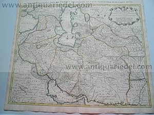
Persia,Afghanistan,Asia,anno 1742, Covens et Mortier
Verlag: Covens & Mortier
Anbieter: Hammelburger Antiquariat, Hammelburg, Deutschland
Verkäuferbewertung 5 von 5 Sternen
Hardcover. Zustand: very good. Coppermap, edited by Covens et Mortier, anno 1742 in Atlas noeveau, Amsterdam, original outline colours, size of the leaf: 54 x 64 cm., Scarce map of the Middle East with Persia in the center of the map.
-

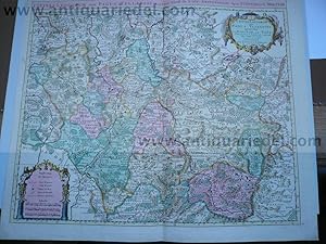
"L'Allemagne dressée sue les Observations de Tycho-Brahe de Kepler de Snellius sue celles de Messieres de l'Academie Royale des Sciences etc. sur Zeiller et autres Auteurs anciens ou modernes" - Deutsches Reich Böhmen Österreich Schweiz Holland Bohemia Silesia Schlesien Polska Polen Polande Österreich Austria Deutschland
Sprache: Französisch
Verlag: Amsterdam, Covens & Mortier c. 1750., 1750
Anbieter: Antiquariat Steffen Völkel GmbH, Seubersdorf, Deutschland
Verkäuferbewertung 5 von 5 Sternen
Karte
Blatt-Maße: ca. 53 x 66 cm. -- Altkolorierte Kupferstich-Karte. -- mit kleinen Plattenfehler, sonst gut erhalten. || Old colored engraved map. -- with a minor plate defect, otherwise in good condition. // Wir, das Antiquariat Steffen Völkel, kaufen und verkaufen alte Bücher, Handschriften, Zeichnungen, Autographen, Grafiken und Fotografien. Wir sind stets am Ankauf von kompletten Bibliotheken, Sammlungen und Nachlässen interessiert. Sprache: Französisch Gewicht in Gramm: 30.
-

"Nova Helvetiae, Foederatarumque cum ca, nec non subditarum Regionum Tabula, ad Usuum serenissimi Burgundiae Ducis." - Schweiz Suisse Switzerland Svizzera / Zürich Bern Konstanz Freiburg Basel Luzern
Sprache: Französisch
Verlag: Amsterdam, Covens u. Mortier ca. 1750., 1750
Anbieter: Antiquariat Steffen Völkel GmbH, Seubersdorf, Deutschland
Verkäuferbewertung 5 von 5 Sternen
Karte
Blatt-Maße: ca. 53 x 66 cm. -- Altkolorierte Kupferstich-Karte. -- gut erhalten. || Old colored engraved map. -- in good condition. // Wir, das Antiquariat Steffen Völkel, kaufen und verkaufen alte Bücher, Handschriften, Zeichnungen, Autographen, Grafiken und Fotografien. Wir sind stets am Ankauf von kompletten Bibliotheken, Sammlungen und Nachlässen interessiert. Sprache: Französisch Gewicht in Gramm: 30.
-

"Le Marquisat de Basse Lusace divisee en ses cercles, seigneuries et senechaussees &c." - Niederlausitz Lausitz Peitz Cottbus Guben / Schlesien Silesia Polska Polen Poland
Sprache: Französisch
Verlag: Amsterdam, Covens u. Mortier ca. 1750., 1750
Anbieter: Antiquariat Steffen Völkel GmbH, Seubersdorf, Deutschland
Verkäuferbewertung 5 von 5 Sternen
Karte
Blatt-Maße: ca. 53 x 66 cm. -- Altkolorierte Kupferstich-Karte. -- gut erhalten. || Old colored engraved map. -- in good condition. // Wir, das Antiquariat Steffen Völkel, kaufen und verkaufen alte Bücher, Handschriften, Zeichnungen, Autographen, Grafiken und Fotografien. Wir sind stets am Ankauf von kompletten Bibliotheken, Sammlungen und Nachlässen interessiert. Sprache: Französisch Gewicht in Gramm: 30.
-

"Le cours du Rhin depuis Strasbourg jusqu'a Worms et les Pays adiacens" - Rhein Rheinlauf Worms Heidelberg Speyer Strasbourg Pforzheim Zweibrücken Rheinzabern Bruchsal Landau Durlach Rastatt Calw Stuttgart Saarlouis Saarbrücken Rheinland-Pfalz Baden-Württemberg Saarland
Sprache: Französisch
Verlag: Amsterdam, Covens & Mortier um 1730., 1730
Anbieter: Antiquariat Steffen Völkel GmbH, Seubersdorf, Deutschland
Verkäuferbewertung 5 von 5 Sternen
Karte
Blatt-Maße: ca. 53 x 66 cm. -- Altkolorierte Kupferstich-Karte. -- gut erhalten. || Old colored engraved map. -- in good condition. // Wir, das Antiquariat Steffen Völkel, kaufen und verkaufen alte Bücher, Handschriften, Zeichnungen, Autographen, Grafiken und Fotografien. Wir sind stets am Ankauf von kompletten Bibliotheken, Sammlungen und Nachlässen interessiert. Sprache: Französisch Gewicht in Gramm: 30.
-

"Le cours du Rhin au dessus de Strasbourg, et le Pays adjacens" - Rhein Rheinlauf Schwarzwald / Black Forest / Strasbourg Freiburg im Breisgau Breisach Basel Schaffhausen Villingen Rottweil Horb Badenweiler Wolfach
Sprache: Französisch
Verlag: Amsterdam, Covens & Mortier um 1730., 1730
Anbieter: Antiquariat Steffen Völkel GmbH, Seubersdorf, Deutschland
Verkäuferbewertung 5 von 5 Sternen
Karte
Blatt-Maße: ca. 53 x 66 cm. -- Altkolorierte Kupferstich-Karte. -- gut erhalten. || Old colored engraved map. -- in good condition. // Wir, das Antiquariat Steffen Völkel, kaufen und verkaufen alte Bücher, Handschriften, Zeichnungen, Autographen, Grafiken und Fotografien. Wir sind stets am Ankauf von kompletten Bibliotheken, Sammlungen und Nachlässen interessiert. Sprache: Französisch Gewicht in Gramm: 30.
-

"Carte du Paraguay du Chili" - Paraguay Chile Argentina Argentinien Brasil Brazil Brasilien Uruguay South America Südamerika
Sprache: Französisch
Verlag: Amsterdam, Covens & Mortier ca. 1750., 1750
Anbieter: Antiquariat Steffen Völkel GmbH, Seubersdorf, Deutschland
Verkäuferbewertung 5 von 5 Sternen
Karte
Blatt-Maße: ca. 66 x 53 cm. -- Großformatige altkolorierte Kupferstich-Karte. -- gut erhalten. || Large old colored engraved map. -- in good condition. // Wir, das Antiquariat Steffen Völkel, kaufen und verkaufen alte Bücher, Handschriften, Zeichnungen, Autographen, Grafiken und Fotografien. Wir sind stets am Ankauf von kompletten Bibliotheken, Sammlungen und Nachlässen interessiert. Sprache: Französisch Gewicht in Gramm: 30.
-

"Carte de Moscovie" - Moscow Russia Russland St. Petersburg Moskau Russie
Sprache: Französisch
Verlag: Amsterdam, Covens & Mortier ca. 1780., 1780
Anbieter: Antiquariat Steffen Völkel GmbH, Seubersdorf, Deutschland
Verkäuferbewertung 5 von 5 Sternen
Karte
Blatt-Maße: ca. 53 x 66 cm. -- Altkolorierte Kupferstich-Karte. -- gut erhalten. || Old colored engraved map. -- in good condition. // Wir, das Antiquariat Steffen Völkel, kaufen und verkaufen alte Bücher, Handschriften, Zeichnungen, Autographen, Grafiken und Fotografien. Wir sind stets am Ankauf von kompletten Bibliotheken, Sammlungen und Nachlässen interessiert. Sprache: Französisch Gewicht in Gramm: 30.
-

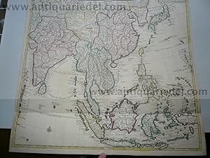
"Carte d'une partie des Indes Orientales, etats du Mogol, les Cotes de Malabar et de Coromandel &c. dresse sur les relations les plus nouvelles" - India Indien Inde / Asia Asien Asie
Sprache: Französisch
Verlag: Amsterdam, Covens & Mortier ca. 1750., 1750
Anbieter: Antiquariat Steffen Völkel GmbH, Seubersdorf, Deutschland
Verkäuferbewertung 5 von 5 Sternen
Karte
Blatt-Maße: ca. 66 x 53 cm. -- Altkolorierte Kupferstich-Karte. -- gut erhalten. || Old colored engraved map. -- in good condition. // Wir, das Antiquariat Steffen Völkel, kaufen und verkaufen alte Bücher, Handschriften, Zeichnungen, Autographen, Grafiken und Fotografien. Wir sind stets am Ankauf von kompletten Bibliotheken, Sammlungen und Nachlässen interessiert. Sprache: Französisch Gewicht in Gramm: 30.
-

"L'Hemisphere septentrional" - Northern Hemisphere America Asia North Pole
Sprache: Französisch
Verlag: Amsterdam, Covens & Mortier ca. 1740., 1740
Anbieter: Antiquariat Steffen Völkel GmbH, Seubersdorf, Deutschland
Verkäuferbewertung 5 von 5 Sternen
Karte
Blatt-Maße: ca. 53 x 73 cm. -- Altkolorierte Kupferstich-Karte. -- leicht fleckig, mit leichten Knickspuren, sonst gut erhalten. || Old colored engraved map. -- slightly stained, with some minor fold marks, otherwise in good condition. // Wir, das Antiquariat Steffen Völkel, kaufen und verkaufen alte Bücher, Handschriften, Zeichnungen, Autographen, Grafiken und Fotografien. Wir sind stets am Ankauf von kompletten Bibliotheken, Sammlungen und Nachlässen interessiert. Sprache: Französisch Gewicht in Gramm: 20.
-

"Carte des Courones du Nord qui comprend les Royaumes de Danemark, Suede, & Norwege, etc." - Scandinavia Skandinavien / Sverige Sweden Schweden Norge Norway Norwegen Danmark Dänemark Denmark Finland Finnland Suomi
Sprache: Französisch
Verlag: Amsterdam, Covens & Mortier ca. 1750., 1750
Anbieter: Antiquariat Steffen Völkel GmbH, Seubersdorf, Deutschland
Verkäuferbewertung 5 von 5 Sternen
Karte
Blatt-Maße: jeweils ca. 53 x 66 cm. -- Altkolorierte Kupferstich-Karte. Von 2 Platten gedruckt. -- gut erhalten. || Old colored engraved map. Printed on two plates. -- in good condition. // Wir, das Antiquariat Steffen Völkel, kaufen und verkaufen alte Bücher, Handschriften, Zeichnungen, Autographen, Grafiken und Fotografien. Wir sind stets am Ankauf von kompletten Bibliotheken, Sammlungen und Nachlässen interessiert. Sprache: Französisch Gewicht in Gramm: 35.
-

"L'Amerique Meridionale dressee sur les memoires le plus recens des meilleurs geographes" - South America Südamerika Colombia Chile Argentina Brasil Venezuela Bolivia / continent Kontinent
Sprache: Französisch
Verlag: Amsterdam, Covens & Mortier, 1757
Anbieter: Antiquariat Steffen Völkel GmbH, Seubersdorf, Deutschland
Verkäuferbewertung 5 von 5 Sternen
Karte
Blatt-Maße: ca. 59 x 67 cm. -- Großformatige altkolorierte Kupferstich-Karte. -- im Mittelfalz etwas hinterlegt, sonst gut erhalten. || Large old colored engraved map. Rare map of South America. -- somewhat deposited on the centerfold, otherwise in very good condition. // Wir, das Antiquariat Steffen Völkel, kaufen und verkaufen alte Bücher, Handschriften, Zeichnungen, Autographen, Grafiken und Fotografien. Wir sind stets am Ankauf von kompletten Bibliotheken, Sammlungen und Nachlässen interessiert. Sprache: Französisch Gewicht in Gramm: 35.