
Gesamtpreis (1 Artikel Artikel):
Versandziel:

covens jean mortier cornelius (12 Ergebnisse)
Direkt zu den wichtigsten Suchergebnissen
Produktart
- Alle Product Types
- Bücher (1)
- Magazine & Zeitschriften
- Comics
- Noten
- Kunst, Grafik & Poster
- Fotografien
- Karten (11)
- Manuskripte & Papierantiquitäten
Zustand
Einband
- alle Einbände
- Hardcover
- Softcover
Weitere Eigenschaften
- Erstausgabe
- Signiert
- Schutzumschlag
- Angebotsfoto (12)
Gratisversand
- Versand nach USA gratis
Land des Verkäufers
Verkäuferbewertung
-
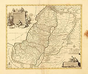
Carte de la Terre Sainte divisée selon les Douze Tribus d'Israel cu sent Exacetement Marquez les Porages de Iesus Christ - dressée pour bien entendre les Histores de la Bible. Par le scu de I. Covens R.C. Mortier
Verlag: Covens & Mortier, Amsterdam, 1755
Anbieter: Antiquariat Reinhold Berg eK Inh. R.Berg, Regensburg, Deutschland
Bewertung:

Karte
Other. Copper engraving, hand colored in outline. In acceptable. At the right side is a brown spot. Not affecting the image. Tears at the bottom. 399 by 466mm (15ľ by 18Ľ inches).
-
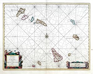
Isles du Cap Verd
Verlag: Covens, Jean - Mortier, Cornelius, Amsterdam, 1720
Cape Verde (Cabo Verde). "Isles du Cap Verd. Hispanis Islas de Cabo Verde. Belgis e Soute Eylanden". Orig. coper-engraving, Covens & Mortier, Amsterdam, ca. 1730. Orig old colouring. With ornamental title-cartouche, another cartouche with the scale of map and a compass rose. 38:49,5 cm (15 x 19,5 inch.). A nautical chart of Cape Verde.
-
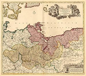
Marchionatus Brandenburgi Et Ducatus Pomeraniae Tabula Quae est pars Septentrionalis Circuli Saxoniae Superioris Authore F. de Wit Amstelodami ex officina I. Covens et C. Mortier.
Verlag: 1740/55, Amsterdam, 1740
Anbieter: Antiquariat Reinhold Berg eK Inh. R.Berg, Regensburg, Deutschland
Bewertung:
Karte
Other. Copper-engraving, handcolored in wash and outline, when published. In the upper right corner ornated with a large barocque title cartouche, surrounded by angels holding coat of arms the various regions. In the lower right corner an allegoric milage scale. In excellent condition. The map in a good equal impression. In decorative body color, as published. 485 by 555mm (19 by 21ľ inches). 485 by 555mm (19 by 21ľ inches).
-
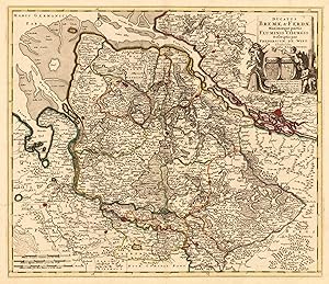
Ducatus Bremae & Ferdae Maximaeque partis Fluminis Visurgis Descriptio per Fredericum De Witt. Amstelodami ex officina R. & J. Ottens.
Verlag: Amsterdam, 1740
Anbieter: Antiquariat Reinhold Berg eK Inh. R.Berg, Regensburg, Deutschland
Bewertung:
Karte
Other. Copper-engraving, handcolored in wash and outline, when published. In the upper right corner ornated with a large barocque title cartouche, with three angels holding the coats of arms of Bremen and Verden. In the lower left corner a small milage scale. In excellent condition. 485 by 555mm (19 by 21ľ inches). 485 by 555mm (19 by 21ľ inches).
-
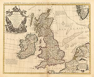
Les Isles ou font le Royaumes D'Angleterre Tiré de sped Celuy D'Ecosse. Tiré de Th. Pont et Celuy D'Irlande Tiré de Petti Le tout Rectifié Par Diverses Observations. par G.De L'Isle Geographe De L'Academie Royale des Sciences. A. Amsteldam Chez I.Convens & C.Mortier Avec Privil.
Verlag: Covens, Amsterdam, 1755
Anbieter: Antiquariat Reinhold Berg eK Inh. R.Berg, Regensburg, Deutschland
Bewertung:
Karte
Other. Original antique copper engraving, hand colored in wash and outline, when published. In the upper left corner ornated with a large allegoric title cartouche (with neptun and sea monsters). In the lower right corner a cartouche with a small milage scale. On this map the British Isles are detailed shown with its neighbouring countries. The map is equipped very much with details. Many small villages and places are named, small rivers and waters, as well along the coast line the sand-banks are named. Still in very good condition. A small mended split at the lower centrefold. 470 by 575mm (18˝ by 22ľ inches). 470 by 575mm (18˝ by 22ľ inches).
-
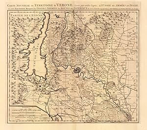
Carte Nouvelle du Territoire de Verone Leyée par ordre Exprés. á l`Usage des Armées en Italie; ou sont Exactement Marqués les Grands Chemins, les Routes des Imperiaux &c. Par le Sr. Sanson,Geograp. du Roy á Amsterdam Chez Pierre Mortier. Ayec Privilege.
Verlag: 1700-04, Amsterdam, 1700
Anbieter: Antiquariat Reinhold Berg eK Inh. R.Berg, Regensburg, Deutschland
Bewertung:
Karte
Other. Copper-engraving, uncolored as published. In excellent condition. 478 by 560mm (18ľ by 22 inches). 478 by 560mm (18ľ by 22 inches).
-
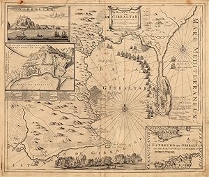
De Haven en Straat von Gibraltar. - Njewlyks getekend, en jn`j ljcht gebracht door Johannes Cóvens en Cornelis Mortier tot Amsterdam.
Verlag: Mortier, Amsterdam, 1710
Anbieter: Antiquariat Reinhold Berg eK Inh. R.Berg, Regensburg, Deutschland
Bewertung:
Karte
Other. Copper engraving, uncolored as published. Decorative map showing the siege of Gibraltar during the Spanish war of succession. This highly interesting map is richly ornated with three additional inset maps and views. The map provides information on fortifications, harbour places, villages, mountains, etc. Further a scene of decorative battle ships is engraved at the bottom. In very good condition, and old mended tear near the lower centre fold. 492 by 586mm (19Ľ by 23 inches). 492 by 586mm (19Ľ by 23 inches).
-
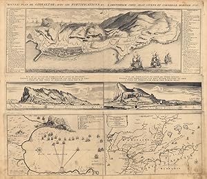
Nouveau plan de Gibraltar, avec ces Fortifications &c. A. Amsterdam Chez Jean Cóvens et Corneille Mortier. 1727. - Vue de la Ville de Gibraltar du Coté du Detroit. Gesigt van de Stadt van Gibraltar von de Straat te Sien. A View of the town of Gibraltar from the bay. - Vue de Gibraltar du Coté du nord ouest. Gesigt van Gibraltar van het noord westen te Sien. A view of Gibraltar from the north west.
Verlag: Covens, Amsterdam, 1727
Anbieter: Antiquariat Reinhold Berg eK Inh. R.Berg, Regensburg, Deutschland
Bewertung:
Karte
Other. Copper engraving, uncolored as published. This large decorative map shows a plan of Gibraltar with its fortifications. The map is equipped with an explanation of the map in the upper right and left corner. In the centre of the map are two views of Gibraltar. At the bottom is an inset map showing the street Gibraltar with the North African coast and the Balearic islands Menorca and Mallorca. The other inset map at the bottom shows the bay of Gibraltar with battle ships. In very good condition. A few marginal spots. 488 by 572mm (19Ľ by 22˝ inches). 488 by 572mm (19Ľ by 22˝ inches).
-
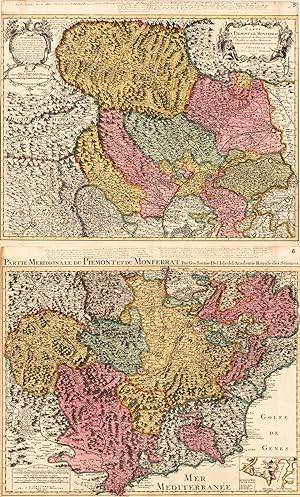
Partie Meridionale du Piemont et du Monferrat, par Guillaume del'Isle del'Academie Royale des Sciences.
Verlag: Covens & Mortier 1700- 1730, Amsterdam, 1700
Anbieter: Antiquariat Reinhold Berg eK Inh. R.Berg, Regensburg, Deutschland
Bewertung:
Karte
Other. Copper engraving, hand colored in outline and wash. In very good condition.few menden split. 2 sheets. 950 by 625mm (37˝ by 24˝ inches). 950 by 625mm (37˝ by 24˝ inches).
-
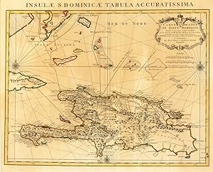
Insulae S. Dominicae Tabula Accuratissima. Carte de L' Isle De Saint Domingue Dressée en 1722 pour l' usage du Roy Sur les memoires de Mr. Frezier Ingenieur de S.M. et autres. Assujettis aux Observations Astronomiques Par G. de l'Isle premier Geographe du Roy, de l'Academie Rle. de Sciences. A Amsterdam Chez Jean Cóvens et Corneille Mortier Geographes.
Verlag: Covens & Mortier 1722-40, Amsterdam, 1722
Anbieter: Antiquariat Reinhold Berg eK Inh. R.Berg, Regensburg, Deutschland
Bewertung:
Karte
Other. Copper engraving handcolored in outline when published. A detailled map covering Haiti (Dominican Republic), the eastern part of Cuba and small islands of the eastern Bahamas (Lucayes islands, Long Island or Yuma, Samana, Mayaguane, Caiques islands). The island Haiti is very detailled engraved, with streets, mountains, rivers and lots of place names along the coast. The map was engraved after the cartographic scources by Guilleaume De I'Isle. A fine copy of this map, in original outline color and in a strong impression. 475 by 615mm (18ľ by 24Ľ inches). 475 by 615mm (18ľ by 24Ľ inches).
-
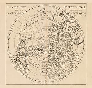
Hemisphere Septentrional pour voir plus distinctement Les Terres Arctiques Par Guillaume De Lisle de l Academie Rle. des Sciences. - A Amsterdam chez Jean Cóvens et Corneille Mortier Libraires.
Verlag: Covens 1700/05, Amsterdam, 1700
Anbieter: Antiquariat Reinhold Berg eK Inh. R.Berg, Regensburg, Deutschland
Bewertung:
Karte
Other. Copper-engraving, uncoloured as published. Fine example of a strong impression of this large map showing the Northern hemisphere with North America, the Arctic, the Pacific, Asia and Europe after the cartographic source by the French map maker Guillaume De Isle. A strong impression in excellent condition. 460 by 460mm (18 by 18 inches). 460 by 460mm (18 by 18 inches).
-
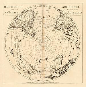
Hemisphere Meridional pour voir plus distinctement Les Terres Australes Par Guillaume De l'Isle de l' Academie Rle. des Sciences. - A Amsterdam chez Jean Cóvens et Corneille Mortier Libraires.
Verlag: Covens 1700/05, Amsterdam, 1700
Anbieter: Antiquariat Reinhold Berg eK Inh. R.Berg, Regensburg, Deutschland
Bewertung:
Karte
Other. Copper engraving, uncolored as published. A strong impression in excellent condition. 464 by 459mm (18Ľ by 18 inches). 464 by 459mm (18Ľ by 18 inches).