
Gesamtpreis (1 Artikel Artikel):
Versandziel:

clark john jefferson (5 Ergebnisse)
Direkt zu den wichtigsten Suchergebnissen
Suchfilter
Produktart
- Alle Product Types
- Bücher (5)
- Magazine & Zeitschriften (Keine weiteren Ergebnisse entsprechen dieser Verfeinerung)
- Comics (Keine weiteren Ergebnisse entsprechen dieser Verfeinerung)
- Noten (Keine weiteren Ergebnisse entsprechen dieser Verfeinerung)
- Kunst, Grafik & Poster (Keine weiteren Ergebnisse entsprechen dieser Verfeinerung)
- Fotografien (Keine weiteren Ergebnisse entsprechen dieser Verfeinerung)
- Karten (Keine weiteren Ergebnisse entsprechen dieser Verfeinerung)
- Manuskripte & Papierantiquitäten (Keine weiteren Ergebnisse entsprechen dieser Verfeinerung)
Zustand Mehr dazu
- Neu (1)
- Wie Neu, Sehr Gut oder Gut Bis Sehr Gut (1)
- Gut oder Befriedigend (2)
- Ausreichend oder Schlecht (Keine weiteren Ergebnisse entsprechen dieser Verfeinerung)
- Wie beschrieben (1)
Einband
Weitere Eigenschaften
- Erstausgabe (3)
- Signiert (Keine weiteren Ergebnisse entsprechen dieser Verfeinerung)
- Schutzumschlag (1)
- Angebotsfoto (4)
Sprache (3)
Gratisversand
Land des Verkäufers
Verkäuferbewertung
-
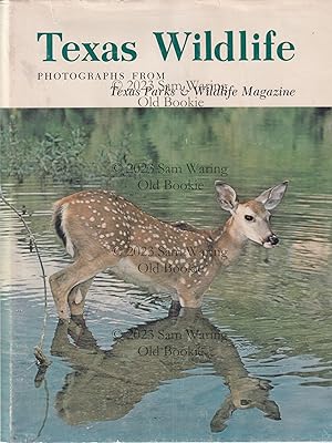
Texas wildlife : photographs from Texas Parks & Wildlife Magazine (Volume 1)
Sprache: Englisch
Verlag: Texas A&M University Press, College Station, TX, 1982
ISBN 10: 089096047X ISBN 13: 9780890960479
Erstausgabe
Hardcover. Zustand: F. Zustand des Schutzumschlags: VG. 1st Edition. 196 pages : color illustrations ; 29 cm. ; green full cloth ; rubbed dj in mylar.
-

Gobernar la crisis.: Los atracos, el Estado y «la ley y el orden»
Anbieter: Agapea Libros, Malaga, MA, Spanien
Verkäuferbewertung 5 von 5 Sternen

Zustand: New. Idioma/Language: Espańol. *** Nota: Los envíos a Espańa peninsular, Baleares y Canarias se realizan a través de mensajería urgente. No aceptamos pedidos con destino a Ceuta y Melilla.
-

Gobernar la crisis.: Los atracos, el Estado y «la ley y el orden»
Anbieter: Librería Pérez Galdós, Madrid, M, Spanien
Verkäuferbewertung 5 von 5 Sternen
Zustand: leido. RUSTICA. 586 páginas.
-
LINWEAVE LIMITED EDITIONS MXMXXXI [1931]
Verlag: The Linweave Association, (Springfield, MA), 1931
Anbieter: Type Punch Matrix, Silver Spring, MD, USA
Verkäuferbewertung 5 von 5 Sternen
Erstausgabe
Zustand: Very good plus. First edition. Luxurious compilation of fine printing and illustration samples, demonstrating the quality of Linweave papers. Collection of ten Linweave Limited Editions, originally distributed as individual mailings sent to publishers and printers to highlight the rich possibilities of Linweave Papers for fine press printing, and presented here as a bound compilation of "present-day American printing at its best". Selections include works by Daniel Chase, illustrated by John Burlin; Po Chu-i, illustrated by Victor Helleu; William Blake, illustrated by Theodore Ross; Samuel Taylor Coleridge, illustrated by Uriel; Robert Southey, illustrated by Paul Hesse; Leigh Hunt, illustrated by Jack Perkins; Edgar Allan Poe, illustrated by Carolyn Edmundson; and Ernest Dowson, illustrated by Jefferson Clark. 12'' x 9''. Original quarter green cloth with pale green boards. Pale green endpapers. Sunning to spine and edges; light scuffing and touches of soil to boards. Occasional smudges to page margins.
-
Travels to the source of the Missouri River and across the American continent to the Pacific Ocean : performed by order of the Government of the United States, in the years 1804, 1805, and 1806. By Capitains Lewis and Clarke. Published from the official report, and illustrated by a map of the route, and other maps. First edition.
Verlag: London: Printed For Longman, Hurst , Rees, Orme and Brown., Paternoster-Row, 1814, 1814
Anbieter: Wittenborn Art Books, San Francisco, CA, USA
Verkäuferbewertung 5 von 5 Sternen
Erstausgabe
Zustand: Good. 4to. 22.5 x 29cm. xxiv, 663 , [1] pages; 4 map plates hors texte (one large folding). Page [664} is the publisher's catalogue .Contemporary boards with later linen spine and label; endpapers renewed, some offsetting present on map and plates, 2 leaves with closed tear.OCLC Number / Unique Identifier:4910831; Wright Howes, 317; Field 929; Howes L-317; Literature of Lewis & Clark 5A.2; Streeter 3128;.The controversial Louisiana Purchase in 1803 - whereby the United States purchased the territory of Louisiana (comprising a stretch of land from today's Montana to Louisiana with Colorado to the West and Missouri to the East) from the French - nearly doubled the size of the country. The cost of the transaction was $15,000,000, around $18 per square mile. Control of the entire area was taken over by the United States, including large areas of the country which was inhabited - and managed - by Native Americans, who had never themselves ceded the land. Following the Purchase, President Thomas Jefferson commissioned an expedition to explore the territory and report back in as much detail as possible. A primary aim was to find a new travel route across the country, ensuring an American presence in the area before other colonial powers took advantage of the area and tried to establish their own footholds. The Lewis and Clark Expedition - alternatively known as the Corps of Discovery Expedition - set out from Camp Dubois on the 14th May 1804, crossing the Continental Divide, eventually reaching St. Louis, Missouri, in 1806. They were famously assisted in interpretation and interactions with local tribes by Sacagawea, a Lemni Shoshone woman who accompanied the expedition.The Lewis and Clark Expedition introduced the United States government to various Native American tribes and how trade with them could be promoted, alongside advising on the viability of the path they followed. Various botanical and zoological specimens were returned to the East Coast, including corn, or maize, grown by Thomas Jefferson at Monticello. It took nearly 10 years for Lewis and Clark to publish their journals, first in Philadelphia in octavo format in 1814 as History of the Expedition under the Command of Captain Lewis and Clark, to the Sources of the Missouri, thence across the Rocky Mountains and down the River Colombia to the Pacific Ocean. Here we find the first British edition, including Neele's highly important folding map, showing the expedition route.
![Bild des Verkäufers für LINWEAVE LIMITED EDITIONS MXMXXXI [1931] zum Verkauf von Type Punch Matrix](https://pictures.abebooks.com/inventory/md/md31075422377.jpg)
