Gesamtpreis (1 Artikel Artikel):
Versandziel:

claes jansz visscher (142 Ergebnisse)
Feedback
Direkt zu den wichtigsten Suchergebnissen
Suchfilter
Produktart
- Alle Product Types
- B³cher (111)
- Magazine & Zeitschriften (Keine weiteren Ergebnisse entsprechen dieser Verfeinerung)
- Comics (Keine weiteren Ergebnisse entsprechen dieser Verfeinerung)
- Noten (Keine weiteren Ergebnisse entsprechen dieser Verfeinerung)
- Kunst, Grafik & Poster (16)
- Fotografien (Keine weiteren Ergebnisse entsprechen dieser Verfeinerung)
- Karten (15)
- Manuskripte & Papierantiquitõten (Keine weiteren Ergebnisse entsprechen dieser Verfeinerung)
Zustand
- Alle
- Neu (Keine weiteren Ergebnisse entsprechen dieser Verfeinerung)
- Antiquarisch (142)
Einband
- alle Einbõnde
- Hardcover (4)
- Softcover (Keine weiteren Ergebnisse entsprechen dieser Verfeinerung)
Weitere Eigenschaften
Sprache (1)
Gratisversand
- Kostenloser Versand nach Deutschland (Keine weiteren Ergebnisse entsprechen dieser Verfeinerung)
Land des Verkõufers
Verkõuferbewertung
-

Visscher-Romankaart van Zeeland.
Anbieter: Antiquariaat A. Kok & Zn. B.V., Amsterdam, Niederlande
Verkõuferbewertung 4 von 5 Sternen

EUR 33,00
Wõhrung umrechnenEUR 15,95 f³r den Versand von Niederlande nach DeutschlandAnzahl: 1 verf³gbar
In den Warenkorb[Alphen a/d Rijn & Middelburg, 1973]. [7, 2] pp. text. 30 plts b./w. plts. Artifical leather. Oblong. - Sl. foxed.Including a full size facsimile of the wallmap 'Zelandiae comitatus novissima tabula' (1655) in 12 maps and a full size facsimile of the 'Speculum Zelandiae' (ca. 1662) in 18 sheets. - With an introduction in Dutch by Johan Grooten.
-
![Bild des Verkõufers f³r [Antique print, etching, execution, ca.1650] Afbeelding der executie geschiet den XIII May 1619 aen Jan van gewesene advocaet van Hollant/Johan van Oldenbarnevelt op het Binnenhof, published ca. 1650, 1 p. zum Verkauf von Antiquariaat Arine van der Steur / ILAB](https://pictures.abebooks.com/inventory/md/md17624538804.jpg)
[Antique print, etching, execution, ca.1650] Afbeelding der executie geschiet den XIII May 1619 aen Jan van gewesene advocaet van Hollant/Johan van Oldenbarnevelt op het Binnenhof, published ca. 1650, 1 p.
Anbieter: Antiquariaat Arine van der Steur / ILAB, Den Haag, Niederlande
Verkõuferbewertung 5 von 5 Sternen

EUR 36,30
Wõhrung umrechnenEUR 10,00 f³r den Versand von Niederlande nach DeutschlandAnzahl: 1 verf³gbar
In den WarenkorbView on the Binnenhof with the execution of Oldenbarnevelt to the right, in front of the Ridderzaal.Captions to the various buildings of the binnenhof:''t Hoff van syn Pr. Excell. Mauritius'; 'de Hoff Kerck'and 'de Groote Saalle'; 'T'HOF VAN HOLLANDT'in the sky; some ribbons collect the words expressed by the various personnages. Titled above:' AFBEELDING DER EXECUTIE. VAN HOLLAN.' and on the bottom:'NERO TAMEN SUBTRAXIT OCULOS. Tacitus in Vita Agricolae.' Etching on paper with some margin; platemark: 131 x 251 mm; total: 163 x 280 mm. Several damages along the margins, evenly yellowed paper. Hollstein 31-copy d; Atlas van Stolk 1418.
-

Portrait of Rudolphus Petri. (Dutch preacher in Amsterdam, Protestant preacher, 1585-1649).
Verlag: [Amsterdam: Dutch Publisher, circa 1649]., 1649
Anbieter: Wittenborn Art Books, San Francisco, CA, USA
Verkõuferbewertung 5 von 5 Sternen
Kunst / Grafik / Poster
EUR 57,03
Wõhrung umrechnenEUR 15,33 f³r den Versand von USA nach DeutschlandAnzahl: 1 verf³gbar
In den WarenkorbZustand: Good. Engraving. 31 x 22 cm (sheet). Very Good, sheet trimmed to the image, a short tear at bottom sheet edge.
-

Antwerp, anno 1624, Visscher
Verlag: Visscher Claes Jansz., 1587-1652, 1652
Anbieter: Hammelburger Antiquariat, Hammelburg, Deutschland
Verkõuferbewertung 5 von 5 Sternen
EUR 300,00
Wõhrung umrechnenEUR 7,00 f³r den Versand innerhalb von/der DeutschlandAnzahl: 1 verf³gbar
In den WarenkorbHardcover. Zustand: very good. Antwerp, anno 1624, Visscher Map of Antwerp and the surrounding region. With an inset bird's eye view of Antwerp below the map. In the top left is a man playing bagpipes, in the top right two figures near a butter churn and a jug. Copperplate engraving, edited by C.J.Visscher, size: 35x47 cm., poor condition, mounted on paper, browned, upper margin is missing, ca. 3-4 cm. loss, left margin also missing. But a original map.
-
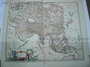
Asiae nova delineatio, Auctore N. Visscher, 1690
Verlag: Visscher Claes Jansz., 1587-1652, 1652
Anbieter: Hammelburger Antiquariat, Hammelburg, Deutschland
Verkõuferbewertung 5 von 5 Sternen
EUR 600,00
Wõhrung umrechnenEUR 7,00 f³r den Versand innerhalb von/der DeutschlandAnzahl: 1 verf³gbar
In den WarenkorbHardcover. Zustand: very good. Asiae nova delineatio, Auctore N. Visscher, 1690, altkoloriert und goldgeh÷ht, Blattma▀: 50x60 cm., etwas gebrõunt, diverse Reparaturen an der Mittelfalz, diese geplatzt.
-
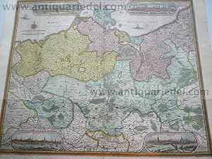
Mecklenburgi/Pommeraniae,Visscher C.J., anno 1630
Verlag: Visscher Claes Jansz., 1587-1652, 1652
Anbieter: Hammelburger Antiquariat, Hammelburg, Deutschland
Verkõuferbewertung 5 von 5 Sternen
Erstausgabe
EUR 790,00
Wõhrung umrechnenEUR 7,00 f³r den Versand innerhalb von/der DeutschlandAnzahl: 1 verf³gbar
In den WarenkorbHardcover. Zustand: very good. Please read german text.Kupferkarte, verlegt von Visscher, C. J., gestochen von A. Goos. "TABULA ELECTORATUS BRANDENBURGICI, MECKELENBURGI, ET MAXIMAE PARTIS POMERANIAE". Kolorierte Karte mit 4 Ansichten von Stettin, Stralsund, Rostock und Frankfurt/O. Hier die erste Ausgabe mit der Datierung 1630, etwas fleckig, seitlich bis an die Einfassungslinie angerõndert, im Bild 3 vertikale und 2 horizontale Faltstellen mit min. rest. Fehlstellen, nachgezeichnet, nicht zu erkennen. 45 x 54 cm.
-

Carthaginensis sinus
Verlag: Claes Jansz. Visscher, Amsterdam, 1649
Anbieter: Antikvariat Krenek, Prag, Tschechien
Verbandsmitglied: ILAB
Verkõuferbewertung 5 von 5 Sternen
Karte
EUR 75,01
Wõhrung umrechnenEUR 12,50 f³r den Versand von Tschechien nach DeutschlandAnzahl: 1 verf³gbar
In den WarenkorbKein Einband. Zustand: Sehr gut. Tunis. "Carthaginensis sinus". Orig. copperplate engraving, C. J. Visscher, Tabulae Geographicae Contrare, Amsterdam, 1649. With ornamental title-cartouche, a sea-creature and a ship. 9:12,5 cm (3 1/2 x 5 inch.). Koeman III, map 8630:341, ed. 341:54 (1649, Tabulae, Visscher). - A miniature map of Lake of Tunis with the city of Tunis.
-

Guinea
Verlag: Claes Jansz. Visscher, Amsterdam, 1649
Anbieter: Antikvariat Krenek, Prag, Tschechien
Verbandsmitglied: ILAB
Verkõuferbewertung 5 von 5 Sternen
Karte
EUR 75,01
Wõhrung umrechnenEUR 12,50 f³r den Versand von Tschechien nach DeutschlandAnzahl: 1 verf³gbar
In den WarenkorbKein Einband. Zustand: Sehr gut. Guinea. "Guinea". Orig. copperplate engraving, C. J. Visscher, Tabulae Geographicae Contrare, Amsterdam, 1649. With ornamental title-cartouche and a sea-creature. 9:12,5 cm (3 1/2 x 5 inch.). Koeman III, map 8700:341, ed. 341:54 (1649 Tabulae, Visscher). - A miniature map of the northern coast of the Gulf of Guinea (Guinea, Sierra Leone, Liberia, Cote d'Ivoire, Ghana, Togo, Benin, Nigeria, Mali, Burkina).
-

De Belegering van de Stadt Hulst. Door syn Hoocheyt den Prince van Orangien int Iaer 1645. La Siege de Hulst. Per Son Alte le Prince D`Orangie l`An 1645.
Verlag: Amsterdam, C. J. Fischer ca. 1645]., 1645
Anbieter: Antiquariat Burgverlag, Wien, ųsterreich
Verbandsmitglied: ILAB VDA VDAO
Verkõuferbewertung 5 von 5 Sternen
EUR 90,00
Wõhrung umrechnenEUR 8,00 f³r den Versand von ųsterreich nach DeutschlandAnzahl: 1 verf³gbar
In den WarenkorbOrig.-Kupferkarte. 26 x 30, 5 cm. (Blattgr.). vgl. Fauser 6004 Gewicht in Gramm: 500.
-
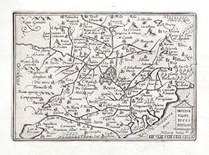
Romanum territorium
Verlag: Claes Jansz. Visscher, Amsterdam, 1649
Anbieter: Antikvariat Krenek, Prag, Tschechien
Verbandsmitglied: ILAB
Verkõuferbewertung 5 von 5 Sternen
Karte
EUR 87,51
Wõhrung umrechnenEUR 12,50 f³r den Versand von Tschechien nach DeutschlandAnzahl: 1 verf³gbar
In den WarenkorbKein Einband. Zustand: Sehr gut. Rome. "Romanum territorium". Orig. copperplate engraving. Published by C. J. Visscher in Amsterdam, 1649 (in Tabulae Geographicae Contractae). Engraved by P. Kaerius. With decorative title cartouche and the scale of map ("Milliaria Italica"). 8,5:12,5 cm. Koeman III, map 9500:341, ed. 341:54 (1649 Tabulae, Visscher). - A miniature map of Campagna di Roma.
-
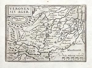
Veronensis Ager
Verlag: Claes Jansz. Visscher, Amsterdam, 1649
Anbieter: Antikvariat Krenek, Prag, Tschechien
Verbandsmitglied: ILAB
Verkõuferbewertung 5 von 5 Sternen
Karte
EUR 87,51
Wõhrung umrechnenEUR 12,50 f³r den Versand von Tschechien nach DeutschlandAnzahl: 1 verf³gbar
In den WarenkorbKein Einband. Zustand: Sehr gut. Verona. "Veronensis Ager". Orig. copperplate engraving. Published by C. J. Visscher in Amsterdam, 1649 (in Tabulae Geographicae Contractae). Engraved by P. Kaerius. With decorative title cartouche and the scale of map ("Scala Milliarium Italicorum"). 9:12,5 cm (3 1/2 x 5 inch.). Koeman III, map 7111:341, ed. 341:54 (1649 Tabulae, Visscher). - A miniature map of of the province of Verona. Oriented to the East. With the city of Verona in the centre and Lago di Garda at the bottom.
-
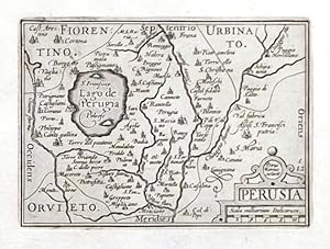
Perusia
Verlag: Claes Jansz. Visscher, Amsterdam, 1649
Anbieter: Antikvariat Krenek, Prag, Tschechien
Verbandsmitglied: ILAB
Verkõuferbewertung 5 von 5 Sternen
Karte
EUR 87,51
Wõhrung umrechnenEUR 12,50 f³r den Versand von Tschechien nach DeutschlandAnzahl: 1 verf³gbar
In den WarenkorbKein Einband. Zustand: Sehr gut. Pergia. "Perusia". Orig. copperplate engraving. Published by C. J. Visscher in Amsterdam, 1649 (in Tabulae Geographicae Contractae). Engraved by P. Kaerius. With decorative title cartouche with the scale of map ("Scala milliarium Italicorum"). 9:12,5 cm (3 1/2 x 5 inch.). Koeman III, map 7340:341, ed. 341:54 (1649 Tabulae, Visscher). - A miniature map of of the province of Perugia. With the Lake Trasimeno ("Lago de Perugia") on the left.
-

Marcha Anconae olim Picenum. 1572
Verlag: Claes Jansz. Visscher, Amsterdam, 1649
Anbieter: Antikvariat Krenek, Prag, Tschechien
Verbandsmitglied: ILAB
Verkõuferbewertung 5 von 5 Sternen
Karte
EUR 87,51
Wõhrung umrechnenEUR 12,50 f³r den Versand von Tschechien nach DeutschlandAnzahl: 1 verf³gbar
In den WarenkorbKein Einband. Zustand: Sehr gut. Marche (Ancona). "Marcha Anconae olim Picenum. 1572". Orig. copperplate engraving. Published by C. J. Visscher in Amsterdam, 1649 (in Tabulae Geographicae Contractae). Engraved by P. Kaerius. With decorative title cartouche and the scale of map ("Milliaria Italica"). 9:12,5 cm (3 1/2 x 5 inch.). Koeman III, map 7350:341, ed. 341:54 (1649 Tabulae, Visscher). - A miniature map of Marche. With the city of Ancona at the bottom. Oriented to the South.
-
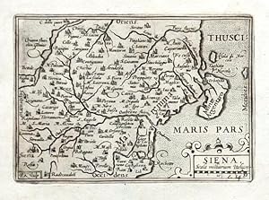
Siena
Verlag: Claes Jansz. Visscher, Amsterdam, 1649
Anbieter: Antikvariat Krenek, Prag, Tschechien
Verbandsmitglied: ILAB
Verkõuferbewertung 5 von 5 Sternen
Karte
EUR 87,51
Wõhrung umrechnenEUR 12,50 f³r den Versand von Tschechien nach DeutschlandAnzahl: 1 verf³gbar
In den WarenkorbKein Einband. Zustand: Sehr gut. Siena. "Siena". Orig. copperplate engraving from N. Visscher's "Tabulae Geographicae Contractae". Published in Amsterdam by C. J. Visscher, 1649. Engraved by P. Kaerius. With decorative title cartouche with the scale of map ("Scala milliarium Italicor"). 9:12,5 cm (3 1/2 x 5 inch.). Koeman III, map 7210:341, ed. 341:54 (1649 Tabulae, Visscher). - A miniature map of of the province of Siena in Tuscany. Oriented to the East.
-
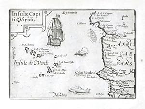
Insulae Capitis Viridis
Verlag: Visscher, Claes Jansz., Amsterdam, 1649
Anbieter: Antikvariat Krenek, Prag, Tschechien
Verbandsmitglied: ILAB
Verkõuferbewertung 5 von 5 Sternen
EUR 87,51
Wõhrung umrechnenEUR 12,50 f³r den Versand von Tschechien nach DeutschlandAnzahl: 1 verf³gbar
In den WarenkorbCape Verde Islands."Insulae Capitis Viridis". Orig. copperplate engraving. Published by C. J. Visscher in Amsterdam, 1649 (in Tabulae Geographicae Contrare). With ornamental title-cartouche, a ship and a sea-creature. 9:12,5 cm (3 1/2 x 5 inch.). Koeman III, 8980:341, ed. 341:54 (1649 Tabulae, Visscher). - A miniature map of Cape Verde Islands.
-
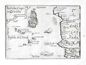
Insulae Capitis Viridis
Verlag: Visscher, Claes Jansz., Amsterdam, 1649
Anbieter: Antikvariat Krenek, Prag, Tschechien
Verbandsmitglied: ILAB
Verkõuferbewertung 5 von 5 Sternen
EUR 87,51
Wõhrung umrechnenEUR 12,50 f³r den Versand von Tschechien nach DeutschlandAnzahl: 1 verf³gbar
In den WarenkorbCape Verde Islands."Insulae Capitis Viridis". Orig. copperplate engraving. Published by C. J. Visscher in Amsterdam, 1649 (in Tabulae Geographicae Contrare). With ornamental title-cartouche, a ship and a sea-creature. 9:12,5 cm (3 1/2 x 5 inch.). Koeman III, 8980:341, ed. 341:54 (1649 Tabulae, Visscher). - A miniature map of Cape Verde Islands.
-

Antique Print-ROMBOUT HOGERBEETS-RUMOLDUS-PORTRAIT-Visscher-c. 1620
Verlag: c. 1620, 1620
Anbieter: Pictura Prints, Art & Books, Overasselt, Niederlande
Verkõuferbewertung 5 von 5 Sternen
Kunst / Grafik / Poster
EUR 95,00
Wõhrung umrechnenEUR 15,00 f³r den Versand von Niederlande nach DeutschlandAnzahl: 1 verf³gbar
In den Warenkorb'ROMBOUT VAN HOOGERBEETS (.).'Original antique print showing a portrait of Rombout Hogerbeets (1561 - 1625), a Dutch statesman and jurist, tried for treason together with Johan van Oldenbarnevelt, Hugo Grotius, and Gilles van Ledenberg during the political crisis of 1617-1618 in the Dutch Republic, and sentenced to life-imprisonment. He shared Loevestein prison with Grotius).Made by after an anonymous artist.Medium: Engraving/etching on hand laid (verge) paper.Sheet size: 12.7 x 17.2 cm (5 x 6.77 inch).ROMBOUT HOGERBEETS-RUMOLDUS-PORTRAIT | PCO-C45-14BACKGROUND INFORMATIONPublished in The Netherlands c. 1620.Biography engraver: Claes Janszoon Visscher (1587 19 June 1652) was a Dutch Golden Age draughtsman, engraver, mapmaker, and publisher. He was the founder of the successful Visscher family mapmaking business. Condition: good, given age. Some soiling and light paper spots. General age-related toning and/or occasional minor defects from handling. Please study scan carefully.
-
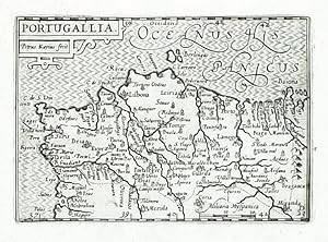
Portugallia
Verlag: Visscher, Claes Jansz., Amsterdam, 1649
Anbieter: Antikvariat Krenek, Prag, Tschechien
Verbandsmitglied: ILAB
Verkõuferbewertung 5 von 5 Sternen
EUR 100,01
Wõhrung umrechnenEUR 12,50 f³r den Versand von Tschechien nach DeutschlandAnzahl: 1 verf³gbar
In den WarenkorbPortugal. "Portugallia". Orig. copperplate engraving. Published by C. J. Visscher in Amsterdam, 1649 (in Tabulae Geographicae Contrare). Engrevd by P. Kaerius (P. van der Keere). With ornamental title-cartouche. 8,5:12,5 cm (3 1/4 x 5 1/4 inch.). Koeman III, map 6300:341, ed. 341:54. - A west-oriented map of Portugal.
-

Candia
Verlag: Visscher, Claes Jansz., Amsterdam, 1649
Anbieter: Antikvariat Krenek, Prag, Tschechien
Verbandsmitglied: ILAB
Verkõuferbewertung 5 von 5 Sternen
EUR 100,01
Wõhrung umrechnenEUR 12,50 f³r den Versand von Tschechien nach DeutschlandAnzahl: 1 verf³gbar
In den WarenkorbCrete (Greece)."Candia". Orig. copperplate engraving. Published by C. J. Visscher in Amsterdam, 1649 (in Tabulae Geographicae Contrare). With ornamental title-cartouche with the scale of map ("Milliaria Germanic.") and a ship. 9:12,5 cm (3 1/2 x 5 inch.). Koeman III, 7900:341, ed. 341:54 (1649 Tabulae, Visscher). - A miniature map Crete.
-

Zante Insula
Verlag: Claes Jansz. Visscher, Amsterdam, 1649
Anbieter: Antikvariat Krenek, Prag, Tschechien
Verbandsmitglied: ILAB
Verkõuferbewertung 5 von 5 Sternen
Karte
EUR 100,01
Wõhrung umrechnenEUR 12,50 f³r den Versand von Tschechien nach DeutschlandAnzahl: 1 verf³gbar
In den WarenkorbKein Einband. Zustand: Sehr gut. Zakynthos (Greece). "Zante Insula". Orig. copperplate engraving. Published by C. J. Visscher in Amsterdam, 1649 (in Tabulae Geographicae Contractae). With ornamental title-cartouche, a ship and a sea-creature. 9:12,5 cm (3 1/2 x 5 inch.). Koeman III, 7878:341, ed. 341:54 (1649 Tabulae, Visscher). - A miniature map of Zakynthos, a Greek island in the Ionian Sea.
-

Cefalonia
Verlag: Claes Jansz. Visscher, Amsterdam, 1649
Anbieter: Antikvariat Krenek, Prag, Tschechien
Verbandsmitglied: ILAB
Verkõuferbewertung 5 von 5 Sternen
Karte
EUR 100,01
Wõhrung umrechnenEUR 12,50 f³r den Versand von Tschechien nach DeutschlandAnzahl: 1 verf³gbar
In den WarenkorbKein Einband. Zustand: Sehr gut. Cephalonia (Greece). "Cefalonia". Orig. copperplate engraving. Published by C. J. Visscher in Amsterdam, 1649 (in Tabulae Geographicae Contractae). With ornamental title-cartouche and a sea-creature. 8,5:12,5 cm (3 1/4 x 5 inch.). Koeman III, 7876:341, ed. 341:54 (1649 Tabulae, Visscher). - A miniature map of Cephalonia or Kefalonia, formerly also known as Kefallinia or Kephallenia, the largest of the Ionian Islands in western Greece.
-
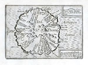
Ins. Sti. Thome
Verlag: Visscher, Claes Jansz., Amsterdam, 1649
Anbieter: Antikvariat Krenek, Prag, Tschechien
Verbandsmitglied: ILAB
Verkõuferbewertung 5 von 5 Sternen
EUR 100,01
Wõhrung umrechnenEUR 12,50 f³r den Versand von Tschechien nach DeutschlandAnzahl: 1 verf³gbar
In den Warenkorb"Ins. Sti. Thome". Orig. copperplate engraving. Published by C. J. Visscher in Amsterdam, 1649 (in Tabulae Geographicae Contrare). With title in map and 2 inset views: "Facies Insulae Annobon ." (2:3,5 cm) and "Facies Ins. Principis ." (1,5:4 cm). 9:12,5 cm (3 1/2 x 5 inch.). Koeman III, 8950:341, ed. 341:54 (1649 Tabulae, Visscher). - A miniature map of St. Thomas, an island off the western equatorial coast of Central Africa.
-

Candia
Verlag: Visscher, Claes Jansz., Amsterdam, 1649
Anbieter: Antikvariat Krenek, Prag, Tschechien
Verbandsmitglied: ILAB
Verkõuferbewertung 5 von 5 Sternen
EUR 100,01
Wõhrung umrechnenEUR 12,50 f³r den Versand von Tschechien nach DeutschlandAnzahl: 1 verf³gbar
In den Warenkorb"Candia". Orig. copperplate engraving. Published by C. J. Visscher in Amsterdam, 1649 (in Tabulae Geographicae Contrare). With ornamental title-cartouche with the scale of map ("Milliaria Germanic.") and a ship. 9:12,5 cm (3 1/2 x 5 inch.). Koeman III, 7900:341, ed. 341:54 (1649 Tabulae, Visscher). - A miniature map Crete.
-

Ins. Sti. Thome
Verlag: Visscher, Claes Jansz., Amsterdam, 1649
Anbieter: Antikvariat Krenek, Prag, Tschechien
Verbandsmitglied: ILAB
Verkõuferbewertung 5 von 5 Sternen
EUR 100,01
Wõhrung umrechnenEUR 12,50 f³r den Versand von Tschechien nach DeutschlandAnzahl: 1 verf³gbar
In den WarenkorbSt. Thomas (Gulf of Guinea)."Ins. Sti. Thome". Orig. copperplate engraving. Published by C. J. Visscher in Amsterdam, 1649 (in Tabulae Geographicae Contrare). With title in map and 2 inset views: "Facies Insulae Annobon ." (2:3,5 cm) and "Facies Ins. Principis ." (1,5:4 cm). 9:12,5 cm (3 1/2 x 5 inch.). Koeman III, 8950:341, ed. 341:54 (1649 Tabulae, Visscher). - A miniature map of St. Thomas, an island off the western equatorial coast of Central Africa.
-
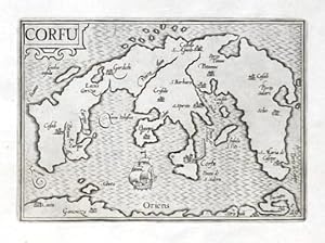
Corfu
Verlag: Claes Jansz. Visscher, Amsterdam, 1649
Anbieter: Antikvariat Krenek, Prag, Tschechien
Verbandsmitglied: ILAB
Verkõuferbewertung 5 von 5 Sternen
Karte
EUR 100,01
Wõhrung umrechnenEUR 12,50 f³r den Versand von Tschechien nach DeutschlandAnzahl: 1 verf³gbar
In den WarenkorbKein Einband. Zustand: Sehr gut. Corfu (Greece). "Corfu". Orig. copperplate engraving. Published by C. J. Visscher in Amsterdam, 1649 (in Tabulae Geographicae Contractae). With ornamental title-cartouche and a ship. 9:12,5 cm (3 1/2 x 5 inch.). Koeman III, 7872:341, ed. 341:54 (1649 Tabulae, Visscher). - A miniature map of Corfu (Kerkyra). Oriented to the West.
-
Angelus in somnis alia discedere terra Iussit, ad herodis nec remeare domum. (Math. 2.12). Gravure originale du XVIIe siĶcle
Verlag: S. n., 1600
Anbieter: Librairie Le Feu Follet, Paris, Frankreich
Verbandsmitglied: ILAB
Verkõuferbewertung 4 von 5 Sternen
Kunst / Grafik / Poster Erstausgabe
EUR 115,00
Wõhrung umrechnenEUR 12,00 f³r den Versand von Frankreich nach DeutschlandAnzahl: 1 verf³gbar
In den WarenkorbPas de couverture. S. n. | s. l. [Hollande] (Circa 1600) | 30 x 27.50 cm | une feuille | Gravure originale non signķe, rķalisķe au burin, probablement par Claes Jansz Visscher, dit le Piscator. Epreuve sur papier vergķ filigranķ, travail du dķbut du XVIIĶme siĶcle. Il s'agit d'une illustration de l'Evangile selon Matthieu 2-12, "Puis, divinement avertis en songe de ne pas retourner vers Hķrode, ils regagnĶrent leur pays par un autre chemin." Lķgende en latin dans la partie infķrieure de la gravure.Mention numķrotķe "12" dans l'angle infķrieur droit dans la gravure, et mention manuscrite "17" en marge dans l'angle supķrieur droit.Une annotation manuscrite ancienne en caractĶres grecs sous l'angle droit de la cuvette.Filigrane d'une couronne visible par transparence.Infimes rousseurs et taches marginales, petites mouillures angulaires, un minuscule trou, le tout sans atteinte Ó la gravure, sinon trĶs bel ķtat de conservation pour cette gravure extrĻmement rare et d'une grande fraŅcheur. | [ENGLISH DESCRIPTION ON DEMAND].
-

Abissinorum Imperium
Verlag: Claes Jansz. Visscher, Amsterdam, 1649
Anbieter: Antikvariat Krenek, Prag, Tschechien
Verbandsmitglied: ILAB
Verkõuferbewertung 5 von 5 Sternen
Karte
EUR 116,68
Wõhrung umrechnenEUR 12,50 f³r den Versand von Tschechien nach DeutschlandAnzahl: 1 verf³gbar
In den WarenkorbKein Einband. Zustand: Sehr gut. Central Africa. "Abissinorum Imperium". Orig. copperplate engraving, C. J. Visscher, Tabulae Geographicae Contrare, Amsterdam, 1649. With ornamental title-cartouche, a ship and a sea-creature. 9:12,5 cm (3 1/2 x 5 inch.). Koeman III, map 8720:341, ed. 341:54 (1649 Tabulae, Visscher). - A miniature map of Central Africa.
-

Sardinia
Verlag: Visscher, Claes Jansz., Amsterdam, 1649
Anbieter: Antikvariat Krenek, Prag, Tschechien
Verbandsmitglied: ILAB
Verkõuferbewertung 5 von 5 Sternen
EUR 125,01
Wõhrung umrechnenEUR 12,50 f³r den Versand von Tschechien nach DeutschlandAnzahl: 1 verf³gbar
In den WarenkorbSardinia (Italy)."Sardinia". Orig. copperplate engraving. Published by C. J. Visscher in Amsterdam, 1649 (in Tabulae Geographicae Contrare). With ornamental title-cartouche and a cartouche with the scale of map ("Miliar. Italica"). 9:12 cm (3 1/2 x 4 3/4 inch.). Koeman III, 7530:341, ed. 341:54 (1649 Tabulae, Visscher). - A miniature map of Sardinia (Sardegna). Oriented to the East.
-
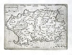
Sardinia
Verlag: Visscher, Claes Jansz., Amsterdam, 1649
Anbieter: Antikvariat Krenek, Prag, Tschechien
Verbandsmitglied: ILAB
Verkõuferbewertung 5 von 5 Sternen
EUR 125,01
Wõhrung umrechnenEUR 12,50 f³r den Versand von Tschechien nach DeutschlandAnzahl: 1 verf³gbar
In den Warenkorb"Sardinia". Orig. copperplate engraving. Published by C. J. Visscher in Amsterdam, 1649 (in Tabulae Geographicae Contrare). With ornamental title-cartouche and a cartouche with the scale of map ("Miliar. Italica"). 9:12 cm (3 1/2 x 4 3/4 inch.). Koeman III, 7530:341, ed. 341:54 (1649 Tabulae, Visscher). - A miniature map of Sardinia (Sardegna). Oriented to the East.
-
Peruana
Verlag: Claes Jansz. Visscher, Amsterdam, 1649
Anbieter: Antikvariat Krenek, Prag, Tschechien
Verbandsmitglied: ILAB
Verkõuferbewertung 5 von 5 Sternen
Karte
EUR 133,34
Wõhrung umrechnenEUR 12,50 f³r den Versand von Tschechien nach DeutschlandAnzahl: 1 verf³gbar
In den WarenkorbKein Einband. Zustand: Sehr gut. South America. "Peruana" (title in map). Orig. copperplate engraving, C. J. Visscher, "Tabulae Geographicae Contractae", Amsterdam, 1649. With engraved title. 8,5:12,5 cm (3 1/2 x 5 inch.). Koeman III, map 9800:341, ed. 341:54 (1649 Tabulae, Visscher). - A miniature map of South America.