Gesamtpreis (1 Artikel Artikel):
Versandziel:

christopher saxton (126 Ergebnisse)
Direkt zu den wichtigsten Suchergebnissen
Suchfilter
Produktart
- Alle Product Types
- Bücher (53)
- Magazine & Zeitschriften (Keine weiteren Ergebnisse entsprechen dieser Verfeinerung)
- Comics (Keine weiteren Ergebnisse entsprechen dieser Verfeinerung)
- Noten (Keine weiteren Ergebnisse entsprechen dieser Verfeinerung)
- Kunst, Grafik & Poster (Keine weiteren Ergebnisse entsprechen dieser Verfeinerung)
- Fotografien (Keine weiteren Ergebnisse entsprechen dieser Verfeinerung)
- Karten (73)
- Manuskripte & Papierantiquitäten (Keine weiteren Ergebnisse entsprechen dieser Verfeinerung)
Zustand Mehr dazu
- Neu (Keine weiteren Ergebnisse entsprechen dieser Verfeinerung)
- Wie Neu, Sehr Gut oder Gut Bis Sehr Gut (5)
- Gut oder Befriedigend (31)
- Ausreichend oder Schlecht (1)
- Wie beschrieben (89)
Einband
Weitere Eigenschaften
Sprache (3)
Gratisversand
Land des Verkäufers
Verkäuferbewertung
-
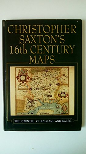
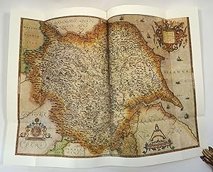
Christopher Saxton's Sixteenth Century Maps
Anbieter: WorldofBooks, Goring-By-Sea, WS, Vereinigtes Königreich
Verkäuferbewertung 5 von 5 Sternen

EUR 0,86
EUR 6,48 Versand
Versand von Vereinigtes Königreich nach USAAnzahl: 2 verfügbar
In den WarenkorbPaperback. Zustand: Good. The book has been read but remains in clean condition. All pages are intact and the cover is intact. Some minor wear to the spine.
-

Knock, Knock!
Sprache: Englisch
Verlag: Penguin Young Readers Group, 2007
ISBN 10: 0803731523 ISBN 13: 9780803731523
Anbieter: Better World Books, Mishawaka, IN, USA
Verkäuferbewertung 5 von 5 Sternen
Zustand: Very Good. Reynolds, Peter C.; Raschka, Christopher; Freymann, Saxton; DePaola, Tomie; Blackall, Sophie (illustrator). Former library copy. Pages intact with possible writing/highlighting. Binding strong with minor wear. Dust jackets/supplements may not be included. Includes library markings. Stock photo provided. Product includes identifying sticker. Better World Books: Buy Books. Do Good.
-
Knock, Knock!
Sprache: Englisch
Verlag: Penguin Young Readers Group, 2007
ISBN 10: 0803731523 ISBN 13: 9780803731523
Anbieter: Better World Books: West, Reno, NV, USA
Verkäuferbewertung 5 von 5 Sternen
Zustand: Very Good. Reynolds, Peter C.; Raschka, Christopher; Freymann, Saxton; DePaola, Tomie; Blackall, Sophie (illustrator). Pages intact with possible writing/highlighting. Binding strong with minor wear. Dust jackets/supplements may not be included. Stock photo provided. Product includes identifying sticker. Better World Books: Buy Books. Do Good.
-
Christopher Saxton's Sixteenth Century Maps
Sprache: Englisch
Verlag: Chatsworth Library, United Kingdom, 1992
ISBN 10: 1853103543 ISBN 13: 9781853103544
Anbieter: WorldofBooks, Goring-By-Sea, WS, Vereinigtes Königreich
Verkäuferbewertung 5 von 5 Sternen
EUR 2,07
EUR 6,48 Versand
Versand von Vereinigtes Königreich nach USAAnzahl: 5 verfügbar
In den WarenkorbPaperback. Zustand: Very Good. The book has been read, but is in excellent condition. Pages are intact and not marred by notes or highlighting. The spine remains undamaged.
-
Hardcover. Zustand: Very Good. No Jacket. Reynolds, Peter C.; Raschka, Christopher; Freymann, Saxton; DePaola, Tomie; Blackall, Sophie (illustrator). May have limited writing in cover pages. Pages are unmarked. ~ ThriftBooks: Read More, Spend Less.
-
Christopher Saxton's 16th Century Maps
Anbieter: AwesomeBooks, Wallingford, Vereinigtes Königreich
Verkäuferbewertung 5 von 5 Sternen
EUR 4,87
EUR 4,77 Versand
Versand von Vereinigtes Königreich nach USAAnzahl: 1 verfügbar
In den WarenkorbHardcover. Zustand: Very Good. Christopher Saxton's 16th Century Maps This book is in very good condition and will be shipped within 24 hours of ordering. The cover may have some limited signs of wear but the pages are clean, intact and the spine remains undamaged. This book has clearly been well maintained and looked after thus far. Money back guarantee if you are not satisfied. See all our books here, order more than 1 book and get discounted shipping. .
-
Zustand: good. Befriedigend/Good: Durchschnittlich erhaltenes Buch bzw. Schutzumschlag mit Gebrauchsspuren, aber vollständigen Seiten. / Describes the average WORN book or dust jacket that has all the pages present.
-
Christopher Saxton's 16th century maps : the counties of England & Wales / with an introduction by William Ravenhill
Sprache: Englisch
Verlag: Shrewsbury : Chatsworth Library, 1992
ISBN 10: 1853103543 ISBN 13: 9781853103544
Erstausgabe
First Edition. Poor cloth copy in an edge-nicked and dust-dulled dust wrapper, now mylar-sleeved. Spine worn. Physical description: 1 atlas (99 p.) : col. ill., col. maps ; 29 cm. Includes bibliographical references (p. 26-27). Subjects: Cartography - History - 16th century. England ; Maps ; Facsimiles. 3 Kg.
-

Map of Kent Sussex Surrey Middlesex Modern Colour Reproduction
Verlag: British Museum, UK, 1965
Anbieter: Maynard & Bradley, Leicester, Vereinigtes Königreich
Verkäuferbewertung 5 von 5 Sternen
Karte
EUR 20,22
EUR 25,42 Versand
Versand von Vereinigtes Königreich nach USAAnzahl: 3 verfügbar
In den WarenkorbSoftcover. Zustand: Very Good. Modern Reproduction. Modern colour-printed facsimile copy of a very attractive Saxton map from the Atlas of the Counties of England (c.1579). It is sized approximately 570 x 450 mm, and printed on thick authentically-coloured paper, durable and attractive to the eye. Bears some very minor superficial creases to edges only. Will be posted to you rolled up in a substantial tube. Why on Amazon do most sellers not describe their actual book? Buy with confidence and support a genuine Independent Bricks & Mortar Real Bookshop. We are Maynard & Bradley CAMBO & PBFA(now lapsed) members here in Leicester City Centre. from c.1575 original. Size: 570 x 450 mm. 1. Item Type: Map. Multiple copies available this title. Quantity Available: 3. Shipped Weight: Under 500 grams. Category: Geography & Maps; Renaissance 16thc to 17thc; Inventory No: 47738.
-

Map of Kent Sussex Surrey Middlesex Modern Colour Reproduction
Verlag: British Museum, UK, 1965
Anbieter: Maynard & Bradley, Leicester, Vereinigtes Königreich
Verkäuferbewertung 5 von 5 Sternen
Karte
EUR 20,22
EUR 25,42 Versand
Versand von Vereinigtes Königreich nach USAAnzahl: 1 verfügbar
In den WarenkorbSoft cover. Zustand: Very Good. Modern colour-printed facsimile copy of a very attractive Saxton map from the Atlas of the Counties of England (c.1579). It is sized approximately 570 x 450 mm, and printed on thick authentically-coloured paper, durable and attractive to the eye. Bears some very minor superficial creases to edges only. Will be posted to you rolled up in a substantial tube. Why on Amazon do most sellers not describe their actual book? Buy with confidence and support a genuine Independent Bricks & Mortar Real Bookshop. We are Maynard & Bradley CAMBO & PBFA(now lapsed) members here in Leicester City Centre. from c.1575 original. Size: 570 x 450 mm. 1. Item Type: Map. Multiple copies available this title. Quantity Available: 3. Shipped Weight: Under 500 grams. Category: Geography & Maps; Renaissance 16thc to 17thc; Inventory No: 02215.
-

Hardcover. Zustand: Fine. 4to (30.5 cm), 100 pp. Publisher's cloth with dust jacket (minor shelf wear). Christopher Saxton was responsible for creating the first printed atlas of the English and Welsh counties, which, when published in 1579, was the first uniform national atlas ever produced for any country. The original set of maps from which this edition is prepared is held in the Library of Chatsworth House, Derbyshire. Not only is it one of the finest hand-coloured examples to survive, but it is also one of only three known privately owned copies. The introduction by William Ravenhill explores the fascinating context in which the maps were created, as well as the methods and techniques used by Saxton to produce his masterpiece. (From the blurb).
-

Media, Myth, and Millennials : Critical Perspectives on Race and Culture
Sprache: Englisch
Verlag: Bloomsbury Publishing PLC, 2019
ISBN 10: 1498577350 ISBN 13: 9781498577359
Zustand: Sehr gut. Zustand: Sehr gut | Seiten: 264 | Sprache: Englisch | Produktart: Bücher | This bookdebunks the post-racial myth among millennial media consumers and producers. Contributors examine the complex ways in which millennial media representations provide audiences with inauthentic understandings of race and how millennials are using social media to combat such misrepresentations.
-

Publications of the Thoresby Society | 1927 | Volume XXVIII Part IV | Miscellanea | Christopher Saxton (the first English Cartographer) of Dunningley; Warburton's Map of Yorkshire (1720)
Verlag: Published by The Thoresby Society, 16 Queen Square, Leeds . 1927., 1927
Anbieter: Little Stour Books PBFA Member, Canterbury, Vereinigtes Königreich
Verbandsmitglied: PBFA
Verkäuferbewertung 5 von 5 Sternen
EUR 17,89
EUR 34,74 Versand
Versand von Vereinigtes Königreich nach USAAnzahl: 1 verfügbar
In den WarenkorbPublisher's original front decorated grey card wrap covers (soft back). 8vo. 9'' x 6''. Contains pp 345-523 [xviii] with monochrome illustrations, tables, one map. Member of the P.B.F.A. YORKSHIRE (Jórvík).
-

Elizabethan Map-Marker by Ifor M. Evans and Heather Lawrence. With also: Christopher Saxton and Tudor map-making.
Sprache: Deutsch
Verlag: Wakefield Historical Publications and the Holland Press. Great Britain., 1979
Anbieter: avelibro OHG, Dinkelscherben, Deutschland
Verbandsmitglied: BOEV
Verkäuferbewertung 5 von 5 Sternen
Zustand: Gut. 2 Pieces. XIV, 186 P. Binding in very good condition. This book is the first to be published on the life and work of Christopher Saxton, the first man to survey and map the counties of England and Wales. Saxton's Atlas was published in 1579 and to celebrate the 400th anniversary of its publication the present authors worked to assemble all that is currently known of the man and his work. Their research has brought to light a body of fresh material which is presented in the book.; - With 1 Frontispiece in color and 19 Plates. - In mint condition. - Extra: Christopher Saxton and Tudor map-making by Sarah Tyacke and John Huddy./ Briitsh Library No. 2. 1980. 24,5 x 18 cm. 64 P. Illustr. Original Paperback, faded. Inside in very clean condition. English Language. deu MIG-26-03A Altersfreigabe FSK ab 0 Jahre Sprache: Deutsch Gewicht in Gramm: 444 29 x 22,5 cm. Original Cloth with gilt back and dust jacket (shop-soiled).
-
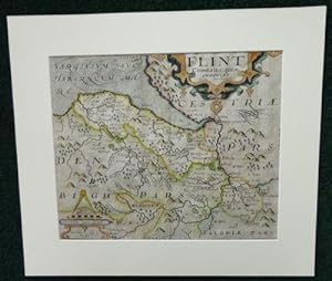
Flint Comitatus
Sprache: Englisch
Erscheinungsdatum: 1637
Anbieter: Madoc Books (ABA-ILAB), Llandudno, CONWY, Vereinigtes Königreich
Verbandsmitglied: ABA ILAB IOBA PBFA
Verkäuferbewertung 5 von 5 Sternen
Karte
EUR 89,45
EUR 34,74 Versand
Versand von Vereinigtes Königreich nach USAAnzahl: 1 verfügbar
In den WarenkorbBoards. Zustand: Very Good. William Kip (illustrator). Actual Map size 31.5*26 cm, mounted 42.5*37 cm, copper engraving highlighted in colour by hand, with a decorative title cartouche, Scala Miliarium and shaded seas, center crease. Saxton, Christopher, map maker and in producing a complete set of county maps of England and Wales, brought to fruition an idea that had been long germinating. Map-consciousness had been growing in the minds of statesmen, developing simultaneously with surveying techniques. Saxton's county maps gained instant recognition at the highest political levels-even while they were still in course of production, between 1574 and 1578, Lord Burghley pulled and annotated early proofs. Saxton's maps were planimetrically superior to those of his predecessors. See ODNB for a full Bio.
-

Espaces inhabitables T.2.
Anbieter: Librairie-Bouquinerie Le Pčre Pénard, Lyon, Frankreich
Verkäuferbewertung 5 von 5 Sternen
in-8 cartonnage éditeur avec jaquette - 1973 - 318p - Ed. Casterman Bon état (légčres rousseurs sur la tranche supérieure, jaquette frottée sur les bordures).
-

Dunelmensis Episcopatus Qui Comitatus Est Palatinus Olim Pars Brigantum
Sprache: Englisch
Verlag: George Bishop & John Norton, London, UK, 1607
Anbieter: Hornseys, Ripon, Vereinigtes Königreich
Verbandsmitglied: PBFA
Verkäuferbewertung 5 von 5 Sternen
EUR 149,08
EUR 28,95 Versand
Versand von Vereinigtes Königreich nach USAAnzahl: 1 verfügbar
In den WarenkorbNo Binding. Zustand: Very Good Plus. 2nd Edition. Original copper-engraved map. Sheet size: 39.7cm x 32.4cm. Blank to the verso. Remnants of old tabs to the good, wide margins. Minor age toning and browning but in very good plus, bright, clean condition overall and a good, strong impression.
-
EBORACENSIS Comitatus Occidentalis vulgo WEST RIDING
Sprache: Englisch
Verlag: London
Anbieter: Hornseys, Ripon, Vereinigtes Königreich
Verbandsmitglied: PBFA
Verkäuferbewertung 5 von 5 Sternen
EUR 417,41
EUR 28,95 Versand
Versand von Vereinigtes Königreich nach USAAnzahl: 1 verfügbar
In den WarenkorbNo Binding. Zustand: Very Good. The earliest printed map dedicated solely to the West Riding. Early seventeenth century. Engraving with contemporary hand-colouring on laid paper. Sheet size: 34.5 cm x 28.4 cm. A finely engraved and highly decorative early map of the West Riding of Yorkshire derived from the groundbreaking county surveys of Christopher Saxton, widely regarded as the father of English cartography. The map was engraved by the Scottish engraver William Hole and forms part of the important early seventeenth-century tradition of reinterpreting Saxton's foundational surveys for a new generation of British atlases and geographical publications. Edition not evident. Blank verso. Impression shows signs of wear to the plate but does not have the added '48' plate number to the left hand corner. Date: c.1610-1637. A strong impression with contemporary or near-contemporary hand-colouring. Historic central fold as issued. General age toning, light surface wear, and minor handling marks consistent with age. The engraving remains sharp and well defined, with clear, legible place names and attractive colour. A well-preserved example of an important early Yorkshire county map.
-
The Kingdome Of England - 1646
Sprache: Englisch
Verlag: Thomas Bassett & Richard Chiswell, London, UK, 1646
Anbieter: Hornseys, Ripon, Vereinigtes Königreich
Verbandsmitglied: PBFA
Verkäuferbewertung 5 von 5 Sternen
EUR 1.132,98
EUR 28,95 Versand
Versand von Vereinigtes Königreich nach USAAnzahl: 1 verfügbar
In den WarenkorbNo Binding. Zustand: Very Good. 1st edition thus. Date: c.1646. Original copper-engraved map based on the work of Christopher Saxton. Early hand-colouring. English text verso. Includes decorative sea monsters in the Irish sea and German Ocean. Sheet size: 55.8cm x 43.7cm. Short, repaired closed tear to the left hand margin. Map a little foxed and age-toned. Crease to upper margin. Remnants of tape verso. In very good, bright, condition overall. Scarce.
-

Dunelmensis Episcopatus
Sprache: Englisch
Erscheinungsdatum: 1637
Anbieter: Hornseys, Ripon, Vereinigtes Königreich
Verbandsmitglied: PBFA
Verkäuferbewertung 5 von 5 Sternen
EUR 77,52
EUR 28,95 Versand
Versand von Vereinigtes Königreich nach USAAnzahl: 1 verfügbar
In den WarenkorbNo Binding. Zustand: Very Good. Original copper engraving. Date: 1637. Sheet size: 34.6cm x 30cm. Early hand-colouring. Close-cropped with very minor age-spotting. Central fold line. In very good, bright, clean condition.
-
Mongomery [Original Hand-Colored Engraved Map]:. Comitatus qui olim pars Ordouicum
Verlag: Camden?s Britannia, 1637
Anbieter: Lux Mentis, Booksellers, ABAA/ILAB, Portland, ME, USA
Verbandsmitglied: ABAA ILAB MABA MBS
Verkäuferbewertung 4 von 5 Sternen

Zustand: Near Fine. Hand coloured map of Montgomery County in Wales. This map was originally published in Camden's Britannia which was the first in which each county was printed on a separate sheet. The first issue of the series was in 1607 (with Latin text at verso) with two editions in 1610 and 1637. The later two had not text on the back and plate numbers may be found on the 1637 issue. Toning notwithstanding, a lovely example with wide margins remaining in an elegant black enamel and gilt frame. Light, even toning, else bright and clean. Hand coloured map. Approximately 15x13" overall, image is 10.5x12.5".
-
An Atlas of England and Wales: The Maps of Christopher Saxton Engraved 1574-1578
Verlag: The Collectors Library of Fine Art, London, 1979
Anbieter: Antipodean Books, Maps & Prints, ABAA, Garrison, NY, USA
Verbandsmitglied: ABAA ANZAAB ESA ILAB
Verkäuferbewertung 4 von 5 Sternen
Signiert
Hardcover. Zustand: Fine. Signed limited edition. Reproduces the exceedingly rare 1579 Saxton Atlas, with an introduction by cartography notable, R.V. Tooley and signed by him. Copy 136 of 500. Commissioned by N.E. Tarbolton. Folio, xiv, (10), 36 folding maps printed in full color. Bound in quarter brown leather and cloth covers with 5 raised bands, housed in publisher's cloth slipcase. Cover slt. marked, otherwise fine. Slipcase marked, small crack at front corner. Complete with the loosely inserted errata sheet and original purchaser's invoice. A magnificent volume.
-

Wiltshire wth. Salisbury Citty & Stone heng described Ano. 1689
Verlag: Sold by Geo: Willdey at the Great Toy, Spectacle, China ware, & PrintShop, the Corner of Ludgate Street near St. Pauls, London, 1576
Anbieter: Clive A. Burden Ltd., Chalfont St. Giles, BUCKS, Vereinigtes Königreich
Verkäuferbewertung 5 von 5 Sternen
Karte Signiert
EUR 1.490,76
EUR 25,65 Versand
Versand von Vereinigtes Königreich nach USAAnzahl: 1 verfügbar
In den WarenkorbNo binding. Zustand: Good. 420 x 475 mm., early outline colour, in good condition. Christopher Saxton's plate of the county of Wiltshire was first produced in 1576. It was the work of the engraver Remigius Hogenberg. The series of county plates passed through the hands of William Web and Philip Lea when they became the property of Lea's widow Anne. On 5 August 1730 the 'Daily Journal' carried an advertisement announcing the sale by auction of 'all the Copper Plates belonging to the Estate of Mrs. Anne Lea, deceased . with all the County Maps of Great Britain and Ireland.' The Saxton plates were acquired by George Willdey (1676?-1737). From 1709 early in his career, Willdey was advertising maps for sale. Willdey's first advertisement announcing the county plates was placed in the 'Daily Post' for 3 February 1732 (illustrated in Hodson I p. 142). They were sold individually for 4d. each. In none of his adverts, up to his death in November 1737, does he mention the county maps be bound as an atlas with a title-page. However, in 1721 when advertising his series of two-sheet maps, he stated that 'This Set of Maps may be fitted up several ways and sizes, or bound in a Book, or sold single, to fit Gentlemens Conveniency .' It can be assumed that he would be just as accommodating with the single sheet county maps and therefore a c.1732 date is reasonable for the atlas.Willdey's last advert was placed in the 'Daily Post', 12 November 1737, which carried in its news columns the announcement that 'Yesterday Morning died of an Apopletick Fit, Mr. Willdey, who kept the noted great Toyshop at the Corner of Ludgate-street by St. Paul's; said to have died very rich.' Curiously although all the newspapers agreed he died on 11 November his will is signed 12 November! The business was continued by Thomas Willdey although it is not clear whether this is George's brother, or son. Thomas died in 1748, and the business was closed as there were many creditors. Evans & Lawrence (1979) pp. 12, 53-8 & 160; Hodson (1984-97) I no. 183; Kingsley 1.8; Shirley (2004) T.Sax 1j; Worms & Baynton-Williams (2011).
-

Monmouthshire
Verlag: London, 1577
Anbieter: Clive A. Burden Ltd., Chalfont St. Giles, BUCKS, Vereinigtes Königreich
Verkäuferbewertung 5 von 5 Sternen
Karte
EUR 1.061,42
EUR 25,65 Versand
Versand von Vereinigtes Königreich nach USAAnzahl: 1 verfügbar
In den WarenkorbNo binding. 395 x 485 mm., early outline colour; short centrefold splits to upper and lower margin, small hole upper centre in the map, repaired, with very large margins, otherwise a fine example. The original Saxton plate was prepared in 1577, the busiest year of production with twelve maps so dated. The presence of Saxton's name on the Burghley proof example led Evans and Lawrence to conclude that the Monmouth was one of those produced later in the year. The plate is unsigned and has not been attributed to any particular engraver. As explained above when Philip Lea acquired the maps he appears to have produced them in two distinct states. The earlier issue is dated to c.1689 and survives in just three known examples. This is an example of this RARE EARLIER STATE before the addition of the roads after John Ogilby and the arms of James Scott, Duke of Monmouth, which would occupy the right hand shield.Philip Lea flourished 1666-1700 as a cartographer, globe and instrument maker and map seller. His atlases were rarely uniform usually being made to order and his editions of Saxton's atlas are similarly varying in content although built around his stock of the original plates. These he acquired sometime around 1689, but from whom is unknown. The fate of some of the plates is unclear but two, Devon and Northumberland, never reappear suggesting that they might have been lost in the Fire. They were replaced by a plate engraved for Lea; that of Devon is signed by Francis Lamb and is offered here under Philip Lea. That of Essex appears to have been unavailable for reasons unknown as Lea issued another. However the original was eventually acquired as examples of Lea's second edition often utilise the Saxton plate. Middlesex was first replaced by John Ogilby's plate of the county c.1673 which had been acquired by Lea. Then Lea acquired five county's published by John Seller which included a Middlesex, he tended to prefer Seller's version. Kent was not bought. Lea had acquired the county maps of Seller by 1693 as the Whitaker copy of the Saxton-Lea atlas can be securely dated to that year and contains the five maps. After acquisition of the Saxton plates Lea set about updating them for publication. This process involved extensive re-engraving of the old plates by incorporating new geographical and decorative material. However during this process some copies of the atlas were sold and two distinct issues have been identified with two different versions of the title page. The early edition dated to c.1689 survives in just three known examples. Lea gradually effected the alterations to the plates he desired which included converting the remaining Latin titles to English, the addition of crowns, crosses and mitres to represent various categories of town. Roads were added to the maps following the publication of John Ogilby's landmark 'Britannia' in 1675. Similarly Hundreds were added to the remaining maps as were town plans. The finished set of plates were completed by 1693 and represent their final cartographic form as only the imprints were altered after this date. In the finished form they also appeared in a French edition entitled 'Atlas Anglois contenant Les Cartes Nouvelles tres Exactes â¦' surviving in a unique example. Evans & Lawrence (1979) pp. 50-3, 61 & 160; Michael (1985) p. 33; Shirley (2004)) T.Sax 1h; Skelton (1970) nos. 110, 112 & 113.
-

Yorkshire
Verlag: George Willdey, London, 1577
Anbieter: Clive A. Burden Ltd., Chalfont St. Giles, BUCKS, Vereinigtes Königreich
Verkäuferbewertung 5 von 5 Sternen
Karte Signiert
EUR 5.366,73
EUR 25,65 Versand
Versand von Vereinigtes Königreich nach USAAnzahl: 1 verfügbar
In den WarenkorbNo binding. 530 x 730 mm. In early outline colour. Repair to central double fold as might be expected, otherwise in good condition. A REMARKABLY FRESH EXAMPLE of one of the most desirable maps in Christopher Saxton's atlas. This map of Yorkshire is one of the five originally signed by Augustine Ryther as engraver and was surveyed during 1577. Christopher Saxton had just received his licence which encouraged him to produce 12 maps in this year, his busiest. Speculation surrounds the origins of Ryther. Ralph Thoresby stated in 1715 that he was 'probably of Leeds' and may well indeed be related to the ennobled family of that name from Yorkshire. He was one of the earliest English born copper plate engravers and signed five of Saxton's maps. It is quite likely he was the author of others. He went on to collaborate on the sale of the Saxton's atlas. Certainly, there is evidence to show that he continued to sell it after the Saxton's ten-year privilege expired. His finest works are the plates for Robert Adams depicting the Spanish Armada published in 1590. Ryther was however in debtor's prison for the winter of 1594-95 and thereafter there is no record. Christopher Saxton produced one of the earliest national surveys of any kind and the first uniformly conceived cartographic survey of England and Wales. It was begun in about 1574 and completed by 1579: "in the long list of British atlases the first name is also the greatest, the name of Christopher Saxton" (Chubb). Saxton (c.1542â"c.1610) was born at Dunningley in the West Riding of Yorkshire. While the details of his early life are sketchy, it is known that he attended Cambridge University, and in 1570 he was apprenticed as a map maker to John Rudd, vicar of Dewsbury. Saxton began work on his county maps in about 1574. In 1577 he received letters patent from Elizabeth I protecting his maps against plagiarism for the next ten years. As well as the Queen's protection, Saxton also enjoyed the patronage of Thomas Seckford, Master of the Queen's Requests, whose mottoes are found on the maps.Evans and Lawrence wrote that he "left a legacy of maps of the counties of England and Wales from which succeeding generations of map-makers drew extensively ⦠amazingly accurate in detail, [the atlas] survives as testimony to his expertise when surveying techniques and comprehension of the mathematical sciences were still limited." They are arguably the most highly prized by collectors of county maps. The map is the only folding map in the atlas and is nearly always damaged as a consequence, this example is as near to perfect as could be expected. Following the death of Philip Lea 25 February 1700 his widow Anne continued the business. Although it is recorded that she sold some copper plates to George Willdey shortly after 1715 those belonging to the Saxton atlas were not amongst them. The date of her death is unknown but on 5 August 1730 the 'Daily Journal' carried an advertisement announcing the sale by auction of 'all the Copper Plates belonging to the Estate of Mrs. Anne Lea, deceased . with all the County Maps of Great Britain and Ireland'. From 1709 early in his career Willdey was advertising maps for sale. Willdey's first advertisement announcing the county plates was placed in the 'Daily Post' for 3 February 1732 (illustrated in Hodson I p. 142). They were sold individually for 4d. each. In none of his adverts up to his death in November 1737 does he mention the county maps be bound as an atlas with a title page. However, in 1721 when advertising his series of two sheet maps, he stated that 'This Set of Maps may be fitted up several ways and sizes, or bound in a Book, or sold single, to fit Gentlemen's Conveniency .' It can be assumed that he would be just as accommodating with the single sheet county maps and that therefore a c.1732 date is reasonable for the atlas.Willdey was not able to secure all the Lea plates despite securing those by Saxton. Some of the maps in the Saxton-Lea atlas were re.
-

Cestriae Comitatus (Romanis Legionibus et Colonys olim insignis) vera et absoluta effigies
Verlag: London, 1577
Anbieter: Clive A. Burden Ltd., Chalfont St. Giles, BUCKS, Vereinigtes Königreich
Verkäuferbewertung 5 von 5 Sternen
Karte
EUR 8.348,24
EUR 25,65 Versand
Versand von Vereinigtes Königreich nach USAAnzahl: 1 verfügbar
In den WarenkorbNo binding. JOHN EVELYN'S COPY. 390 x 515 mm., early wash colour, with the early bunch of grapes watermark, a very good example. JOHN EVELYN'S COPY. The first printed map of Cheshire in the usual second state, first published. In the year 1577 Saxton produced the greatest number of county maps, twelve bear the date. This was most probably due to the protection afforded that year by Queen Elizabeth I and granted for a period of ten years. The omission of Saxton's imprint above the scale of miles from the Burghley proof example, led Evans and Lawrence to conclude that the Cheshire was one of those produced earlier in the year. It is engraved by Francis Scatter and along with that of Staffordshire they are the only two attributed to him. Indeed, these are his only known works. Christopher Saxton produced one of the earliest national surveys of any kind and the first uniformly conceived cartographic survey of England and Wales. It was begun in about 1574 and completed by 1579: 'in the long list of British atlases the first name is also the greatest, the name of Christopher Saxton' (Chubb). Saxton (c.1542â"c.1610) was born in the Dunningley, West Riding of Yorkshire. While the details of his early life are sketchy, it is known that he attended Cambridge University, and in 1570 he was apprenticed as a map maker to John Rudd, vicar of Dewsbury. Saxton began work on his county maps in about 1574. In 1577 he received letters patent from Elizabeth I protecting his maps against plagiarism for the next ten years. As well as the Queen's protection, Saxton also enjoyed the patronage of Thomas Seckford, Master of the Queen's Requests, whose mottoes are found on the maps. Evans and Lawrence wrote that he 'left a legacy of maps of the counties of England and Wales from which succeeding generations of map-makers drew extensively ⦠amazingly accurate in detail, [the atlas] survives as testimony to his expertise when surveying techniques and comprehension of the mathematical sciences were still limited.' They are arguably the most highly prized by collectors of county maps.This example is from John Evelyn's copy of the atlas which sold in his library sale at Christie's London in 1978. Evelyn (1620-1706) is most known as a diarist, he was a founding member of the Royal Society, government official and keen gardener. Provenance: Ex John Evelyn's copy Christie's 16 March 1978 lot 1303 to Desmond Burgess; private English collection. Barber (2007); Chubb (1927) I; Evans & Lawrence (1979) pp. 9â"43; Harley (1979); Hind (1952-55) vol. 1 p. 99; Lawrence (1984); Shirley (2007); Skelton (1970) 1; Whittaker (1942) 1; Worms & Baynton-Williams (2011).
-
An Atlas of England and Wales.
Verlag: London: Christopher Saxton, 1579, 1579
Anbieter: Arader Galleries - AraderNYC, New York, NY, USA
Verkäuferbewertung 5 von 5 Sternen
Erstausgabe
Folio (17 1/2 x 12 in.; 44.5 x 30.5 cm). Letterpress index (fourth setting with 4-line heading and 3 columns), double-page engraved plate of coats of arms (total of 84 with one left blank) and table of counties with contemporary full hand-coloring, 35 double-page engraved plates (Yorkshire folding), after Saxton by Hogenberg, Lenaert Terwoort, Cornelis de Hooghe, Augustine Ryther, Francis Scatter, and Nicholas Reynolds, paper with the crossed sword watermark, maps of Northhamptonshire and Norfolk in the second state, 9 maps bearing Seckford's pre-1576 motto ("Pestis patriae pigricies") and 24 his later motto ("Industria naturam ornate"); extra-illustrated with 4 maps tipped in: Seller, "J. Buckinamiae comitatus vulgo Buckinghamshire" (London, 1733); Boazio, [Irlandiae accurata desciptio" London, 1599] (lefthand sheet only); Ortelius, "Eryn. Hiberniae Briannicae insulae" [Antwerp, 1584]; Ortelius, "Scotiae tabula" [Antwerp, c. 1582], all but 3 maps in FINE FULL CONTEMPORARY HAND-COLOR (Cornwall and additional map of Buckingham plain, Yorkshire in contemporary outline color). Lacking engraved frontispiece of patron and dedicatee Queen Elizabeth I, maps of Cornwall and Yorkshire replaced with maps from the Philip Lea edition of Saxton ca. 1689, some minor mostly marginal soiling, map of Norfolk browned, one or two early repairs to folds on verso. Contemporary limp vellum; stained, nearly detached, lacking leather ties. (64V1D) FIRST EDITION, THE MACCLESFIELD COPY WITH CONTEMPORARY HAND-COLORING OF THE MOST CELEBRATED AND EARLIEST ATLAS OF ENGLAND AND WALES. The index has been annotated in a late 16th-century hand to include the additional maps of Ireland and Scotland, and with the same hand annotating the map of Cheshire to show Macclesfield, the map of Lancaster to show Harrington Park (owned by ancestors of the Stanley family). Map making became increasingly prevalent during the reign of Elizabeth I due to advances in surveying techniques and copperplate engraving. At the same time, state officials began to realize the political and administrative advantages of accurate maps. Among them was Elizabeth's shrewd chief advisor, William Cecil, Lord Burghley, who relentlessly tracked politically volatile areas such as the Anglo-Scottish border. He was instrumental in ensuring that court official Thomas Seckford financed the first comprehensive survey of the counties of England and Wales. In turn, Seckford commissioned Saxton to undertake the task of producing an atlas of England and Wales. All the maps bear Seckford's arms in tandem with the Royal Arms (with the exception of Norfolk which lacks the latter), thus reflecting his deep involvement in this monumental enterprise. For his part, Burghley retained proofs of all the maps, which are now housed at the British Library. Widely considered the father of British cartography, Christopher Saxton grew up in Yorkshire and received his early training in surveying from the local vicar, John Rudd. Begun in 1574, Saxton's survey produced its first map (Norfolk) that year. All the maps are dated between 1574 and 1578, with the exception of Northumberland (undated) and Anglia (dated 1579 and probably the last to be completed). Dutch and Flemish engravers were employed to produce fifteen of the maps with additional contributions by skilled English artisans. The main geographical features on the maps include detailed depictions of rivers, streams, hills and mountains, parks, and woodlands. Woods are shown by small tree symbols, with clusters representing forests. Parklands are enclosed with ring fences while a small building with a spire represents a village. In consideration of the work and expense involved, Queen Elizabeth, to whom the atlas is dedicated, granted Saxton a license in 1577 for the exclusive publication of the maps for a period of ten years. An unparalleled commercial success, the atlas formed the basis of English regional mapping for more than a century, prompting attempts at si.
-
The Shires of England and Wales Described by Christopher Saxton: Being the Best and Original Mapps, with Many Additions and Corrections by Philip Lea.
Verlag: Sold By Thomas Jefferys.in Red Lyon Street Near St. John's Gate, London, 1749
Anbieter: Arader Galleries - AraderNYC, New York, NY, USA
Verkäuferbewertung 5 von 5 Sternen
The Shires of England and Wales Described by Christopher Saxton: Being the Best and Original Mapps, with Many Additions and Corrections by Philip Lea. London: Sold by Thomas Jefferys.in Red Lyon Street near St. John's Gate, [1749] Folio (18 1/4 x 12 1/4 in.; 46.5 x 31 cm). Engraved title-page, 38 double-page or folding regional andcounty maps handcolored in outline; the maps neatly numbered in manuscript on the title-page index, a few minor marginal tears and foxing or staining, some creases. Half calf over blue marbled boards, the spine in 6 compartments with raised bands, one with red morocco lettering piece, the others with repeat gilt decoration; rebacked, preserving original spine, corners and endpapers renewed. Of the 38 maps in this atlas, 29 show evidence of erasures of George Willdey's imprint in the cartouches. According to Evans & Lawrence, "Willdey's imprints have been erased [in the Jefferys 1749 edition], leaving many of the maps scarcely distinguishable from those of Lea's last edition in c. 1693; All Saxton's plates had reached their final state, cartographically, by c. 1693; alterations thereafter were minimal" (p. 58). The map of Cambridgeshire is by Jonas Moore, Hertfordshire by John Seller, Middlesex by John Ogilby and engraved by William Binneman, and the map of Devonshire was engraved by Francis Lamb.
-
An Atlas of England and Wales.
Verlag: London: Christopher Saxton, 1579 [c. 1590], 1590
Anbieter: Arader Galleries - AraderNYC, New York, NY, USA
Verkäuferbewertung 5 von 5 Sternen
Erstausgabe
Folio (16 3/8 x 11 1/2 in.; 41.6 x 29.2 cm). Engraved frontispiece in contemporary handcoloring heightened in gold depicting an enthroned Queen Elizabeth I as the patron of Geography and Astronomy (Hind state II with the dress falling in folds between her knees) attributed to Remigius Hogenberg, letterpress index leaf (setting D), handcolored double-page engraved plate of coats of arms and a table of counties, 35 double-page engraved (Yorkshire folding) after Saxton by Hogenberg, Lenaert Terwoort, Cornelis de Hooghe, Augustine Ryther, Francis Scatter, and Nicholas Reynolds, ALL WITH CONTEMPORARY HANDCOLORING, most watermarked with a small bunch of grapes; minor marginal losses to frontispiece, index cut round and mounted, top margins of maps of Kent (Cantium) and Wilton shaved, Wilton also with tiny burnhole not significantly affecting map, minor marginal staining or foxing affecting approximately 6 maps, margins of Southampton and Devonshire somewhat tender and frayed. Eighteenth-century mottled calf, the spine gilt (one lettered) in seven compartments with raised bands; mottling oxidized. (64V1D) A MAGNIFICENT COPY WITH CONTEMPORARY HAND-COLORING OF THE FIRST EDITION OF THE MOST CELEBRATED AND EARLIEST ATLAS OF ENGLAND AND WALES, THE DITCHLEY COPY. Map making became increasingly prevalent during the reign of Elizabeth I due to advances in surveying techniques and copperplate engraving. At the same time, state officials began to realize the political and administrative advantages of accurate maps. Among them was Elizabeth's shrewd chief advisor, William Cecil, Lord Burghley, who relentlessly tracked politically volatile areas such as the Anglo-Scottish border. He was instrumental in ensuring that court official Thomas Seckford financed the first comprehensive survey of the counties of England and Wales. In turn, Seckford commissioned Saxton to undertake the task of producing an atlas of England and Wales. All the maps bear Seckford's arms in tandem with the Royal Arms (with the exception of Norfolk which lacks the latter), thus reflecting his deep involvement in this monumental enterprise. For his part, Burghley retained proofs of all the maps, which are now housed at the British Library. Christopher Saxton grew up in Yorkshire and received his early training in surveying from the local vicar, John Rudd. Begun in 1574, Saxton's survey produced its first map (Norfolk) that year. All the maps are dated between 1574 and 1578, with the exception of Northumberland (undated) and Anglia (dated 1579 and probably the last to be completed). This copy has the coats of arms plate issued circa 1589, suggesting that it was printed about 1590 "when the atlas assumed its definitive form" (Skelton). Dutch and Flemish engravers were employed to produce fifteen of the maps with additional contributions by skilled English artisans. The main geographical features on the maps include detailed depictions of rivers, streams, hills and mountains, parks, and woodlands. Woods are shown by small tree symbols, with clusters representing forests. Parklands are enclosed with ring fences while a small building with a spire represents a village. In consideration of the work and expense involved, Queen Elizabeth, to whom the atlas is dedicated, granted Saxton a license in 1577 for the exclusive publication of the maps for a period of ten years. An unparalleled commercial success, the atlas formed the basis of English regional mapping for more than a century, prompting attempts at similar enterprises by cartographers such as John Speed, John Norton, Michael Drayton, and Philip Lea, who adapted and added to Saxton's magnum opus. REFERENCES: Chubb 1; ESTC S123137; Skelton 1 PROVENANCE: Ditchley bookplate on front pastedown dated 1903 (almost certainly that of Harold Lee-Dillon, 17th Viscount Dillon, 1844-1942. Dillon-Lee's family home was Ditchley, Oxfordshire, the estate originally purchased by his ancestor Sir Henry Lee, 1533-1611, who was the Queen's champion.
-
![Bild des Verkäufers für [Essex]. Essexia comitatvs, qvem olim trinobantes tenuerunt continens in se opida marcatoria. zum Verkauf von Robert Frew Ltd. ABA ILAB](https://pictures.abebooks.com/inventory/md/md30894930063.jpg)
[Essex]. Essexia comitatvs, qvem olim trinobantes tenuerunt continens in se opida marcatoria.
Verlag: LondonImpensis Georgii Bishop & Ioannis Norton ., 1610
Anbieter: Robert Frew Ltd. ABA ILAB, London, Vereinigtes Königreich
Verbandsmitglied: ABA ILAB PBFA
Verkäuferbewertung 5 von 5 Sternen
Karte Erstausgabe
EUR 89,45
EUR 11,58 Versand
Versand von Vereinigtes Königreich nach USAAnzahl: 1 verfügbar
In den WarenkorbOriginal uncoloured engraved map of Essex showing parts of London in bottom right corner, trimmed to neatline and backed onto 18th century laid paper. Map dimensions 28.5 x 36.5 cm, overall backing-sheet size 32 x 40 cm. Small losses near upper centre and bottom right corner, a bit toned overall and with a few trivial blemishes. An early decorative map of Essex engraved by William Kip based on the earlier maps by Elizabethan cartographer Christopher Saxton first published in the 1607 edition of William Camden's Britannia.* This example is from the first English edition of Camden's Britannia published in 1610, without any text on the verso. Embellished with decorative cartouche. *Britannia, first published in 1586, was one of the most popular and influential books of the period. The work of the Elizabethan antiquarian, William Camden (1551-1623), it was a detailed historical and topographical description of Great Britain. Its patriotic sentiments, in particular, both appealed to and generated the growing sense of nationalism that was coursing through late Tudor / early Stuart society. Between 1607 and 1637, county maps engraved by William Kip and William Hole, and based largely on Saxton's surveys, were added. (Skelton, 6).