Gesamtpreis (1 Artikel Artikel):
Versandziel:

charles b yule (10 Ergebnisse)
Direkt zu den wichtigsten Suchergebnissen
Suchfilter
Produktart
- Alle Product Types
- Bücher (10)
- Magazine & Zeitschriften (Keine weiteren Ergebnisse entsprechen dieser Verfeinerung)
- Comics (Keine weiteren Ergebnisse entsprechen dieser Verfeinerung)
- Noten (Keine weiteren Ergebnisse entsprechen dieser Verfeinerung)
- Kunst, Grafik & Poster (Keine weiteren Ergebnisse entsprechen dieser Verfeinerung)
- Fotografien (Keine weiteren Ergebnisse entsprechen dieser Verfeinerung)
- Karten (Keine weiteren Ergebnisse entsprechen dieser Verfeinerung)
- Manuskripte & Papierantiquitäten (Keine weiteren Ergebnisse entsprechen dieser Verfeinerung)
Zustand Mehr dazu
- Neu (5)
- Wie Neu, Sehr Gut oder Gut Bis Sehr Gut (1)
- Gut oder Befriedigend (4)
- Ausreichend oder Schlecht (Keine weiteren Ergebnisse entsprechen dieser Verfeinerung)
- Wie beschrieben (Keine weiteren Ergebnisse entsprechen dieser Verfeinerung)
Einband
Weitere Eigenschaften
- Erstausgabe (1)
- Signiert (1)
- Schutzumschlag (Keine weiteren Ergebnisse entsprechen dieser Verfeinerung)
- Angebotsfoto (3)
Sprache (3)
Preis
- Beliebiger Preis
- Weniger als EUR 20 (Keine weiteren Ergebnisse entsprechen dieser Verfeinerung)
- EUR 20 bis EUR 45
- Mehr als EUR 45
Gratisversand
Land des Verkäufers
Verkäuferbewertung
-
The Australia Directory, Vol. 2
Anbieter: PBShop.store US, Wood Dale, IL, USA
Verkäuferbewertung 5 von 5 Sternen

PAP. Zustand: New. New Book. Shipped from UK. Established seller since 2000.
-
The Australia Directory, Vol. 2
Anbieter: PBShop.store UK, Fairford, GLOS, Vereinigtes Königreich
Verkäuferbewertung 5 von 5 Sternen
EUR 30,39
EUR 5,81 Versand
Versand von Vereinigtes Königreich nach USAAnzahl: 15 verfügbar
In den WarenkorbPAP. Zustand: New. New Book. Shipped from UK. Established seller since 2000.
-

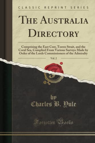
The Australia Directory, Vol. 2: Comprising the East Cost, Torres Strait, and the Coral Sea, Complied From Various Surveys Made by Order of the Lords Commissioners of the Admiralty (Classic Reprint)
Anbieter: PBShop.store US, Wood Dale, IL, USA
Verkäuferbewertung 5 von 5 Sternen
HRD. Zustand: New. New Book. Shipped from UK. Established seller since 2000.
-
The Australia Directory, Vol. 2: Comprising the East Cost, Torres Strait, and the Coral Sea, Complied From Various Surveys Made by Order of the Lords Commissioners of the Admiralty (Classic Reprint)
Anbieter: PBShop.store UK, Fairford, GLOS, Vereinigtes Königreich
Verkäuferbewertung 5 von 5 Sternen
EUR 38,73
EUR 6,80 Versand
Versand von Vereinigtes Königreich nach USAAnzahl: 15 verfügbar
In den WarenkorbHRD. Zustand: New. New Book. Shipped from UK. Established seller since 2000.
-

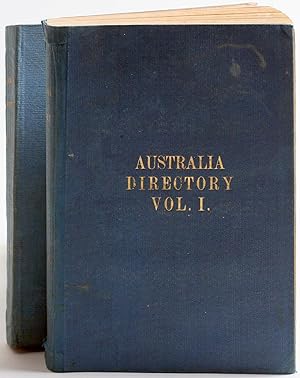
The Australia Directory Volume I - South and East Coasts From Cape Leeuwin to Port Jackson; Including Bass Strait; and Tasmania
Verlag: Hydrographic Office, 1897
Anbieter: Books From California, Simi Valley, CA, USA
Verkäuferbewertung 4 von 5 Sternen

Hardcover. Zustand: Good. Volume I ONLY. Some staining to boards, general age wear. Pages clean, binding sturdy.
-
Facts Behind the Fame of Santa Barbara County.
Verlag: Santa Barbara, CA: First National Trust and Savings Bank of Santa Barbara, [1960s]., 1960
Anbieter: Wittenborn Art Books, San Francisco, CA, USA
Verkäuferbewertung 5 von 5 Sternen
Zustand: Good. 8vo. [48 pp.]. Very Good. Soft Covers. Pages fine. B&W plates throughout.
-

The Australia Directory, Vol. 2 : Comprising the East Cost, Torres Strait, and the Coral Sea, Complied from Various Surveys Made by Order of the Lords Commissioners of the Admiralty (Classic Reprint)
Anbieter: AHA-BUCH GmbH, Einbeck, Deutschland
Verkäuferbewertung 5 von 5 Sternen
Taschenbuch. Zustand: Neu. Neuware.
-
Zustand: Sehr gut. Zustand: Sehr gut | Seiten: 458 | Sprache: Englisch | Produktart: Bücher | Keine Beschreibung verfügbar.
-
Routier de l'Australie (Côte est) Détroit de Torrčs et Mer de Corail. Volume II [ Edition originale - Livre dédicacé par l'auteur ]
Sprache: Französisch
Verlag: Imprimerie Administrative de Paul Dupont, 1861
Anbieter: Librairie du Cardinal, GRADIGNAN, Frankreich
Verkäuferbewertung 5 von 5 Sternen
Erstausgabe Signiert
rigide. Zustand: Assez bon. Traduit et annoté d'aprčs les travaux hydrographiques les plus récents par A. le Gras., 1 vol. in-8 reliure de l'époque demi-chagrin rouge ŕ coins dos orné, double filet doré en mors et coins, coll. Dépôt des Cartes et Plans de la Marine, n° 312, Imprimerie Administrative de Paul Dupont, 1861, XXIII-566 pp. avec une grande carte dépliante Exemplaire dédicacé par Le Gras ("hommage de profond respect de l'auteur"). L'ouvrage provient de la bibliothčque de Prosper de Chasseloup-Laubat, ministre de la Marine et des Colonies, sous le ministčre duquel le présent ouvrage fut publié. Etat trčs satisfaisant (rel. et coupes un peu frottée avec petites épidermures, marges de la carte un peu frottée, bon état par ailleurs). Polak, 9616 Langue: Français. signé par l'auteur.
-
The Australia Directory: Volumes 1: South and East Coasts, Bass Strait, and Tasmania; Volume II Comprising the East Coast, Torres Strait, and the Coral Sea; Volume III North, North-west, and West Coasts, from the Gulf of Carpentaria to Cape Leeuwin
Verlag: Hydrographic Office, Admiralty, London, 1881
Anbieter: Antipodean Books, Maps & Prints, ABAA, Garrison, NY, USA
Verbandsmitglied: ABAA ANZAAB ESA ILAB
Verkäuferbewertung 3 von 5 Sternen

Zustand: Very good condition. Maritime surveys undertaken on expeditions to the south and east coasts of Australia, compiled by Captain Charles Bampfield Yule (1806 - 1878), English explorer and commander of the HMS Bramble, which with the HMS Rattlesnake made surveys of the East Indies Station. The 1846-1850 expedition to Cape York and Torres Strait was made by Yule in command of the Bramble and the Rattlesnake under the command of Captain Owen Stanley, with the naturalists John MacGillivray and James Fowler Wilcox, and the biologist and staunch supporter of Darwin's theory of evolution, Thomas Henry Huxley. Volume I with pencil notations and calculations at ffep; it appears the volume was used as a teaching aid. Volume II with more pencil calculations at ffep, and a note "May 11 1898 trip 106 days from New York to Brisbane". Reproductions exist of the 1897 edition only. Three volumes, 8vo, Vol I: xii, 543 pages; Vol. II: xvi, 436 pages; Vol. III: xii, 332 pages. Volume I, Sixth edition, OCLC: 220747280; Trove Libraries Australia ID 7535957. Volume II, Second edition, OCLC: 220750382. Volume III, 2nd edition, OCLC: 223279625. Original publishers blue gilt cloth, Vol I & II covers a bit marked. Vol III spine sunned, chip at foot of spine, hinges a bit rubbed, one signature loose in prelims. Overall, clean copies of these scarce items. Sixth edition: Second edition: Second edition.

![Bild des Verkäufers für Routier de l'Australie (Côte est) Détroit de Torrčs et Mer de Corail. Volume II [ Edition originale - Livre dédicacé par l'auteur ] zum Verkauf von Librairie du Cardinal](https://pictures.abebooks.com/inventory/md/md31544724072.jpg)